Advertisement
If you have a new account but are having problems posting or verifying your account, please email us on hello@boards.ie for help. Thanks :)
Hello all! Please ensure that you are posting a new thread or question in the appropriate forum. The Feedback forum is overwhelmed with questions that are having to be moved elsewhere. If you need help to verify your account contact hello@boards.ie

Interesting Maps

15681011338

Comments

  • Banned (with Prison Access) Posts: 9,078 IAMAMORON
    ✭✭✭


    greenspurs wrote: »
    And Russia and Eastern Europe are fond of Anal !!! :eek::D

    In fairness everyone knew that already. :D


  • Beasty wrote: »
    Thread returned from a Geography trip

    To celebrate, here's a map of a bus service at an airport

    CWlGCPI.jpg

    Because, you know, After Hours is a cesspit etc.


  • IAMAMORON wrote: »
    In fairness everyone knew that already. :D

    Actually, I didn’t. But there again, I‘ve never been too either place


  • Closed Accounts Posts: 5,995 Ipso
    ✭✭✭


  • Moderators, Recreation & Hobbies Moderators Posts: 12,437 igCorcaigh
    Mod ✭✭✭✭


  • Advertisement
  • Registered Users, Registered Users 2 Posts: 3,862 mikhail
    ✭✭✭


    igCorcaigh wrote: »
    The location reminds me of the Sahara Sea proposals, a collections of climate engineering projects (mostly a century+ old) to flood basins in the Sahara using seawater from the Med or the Atlantic. Here's one of them:
    1280px-All_proposed_routes.PNG


  • Registered Users, Registered Users 2 Posts: 14,204 Deja Boo
    ✭✭✭✭


    xbJHmQM.jpg?1


  • Registered Users, Registered Users 2 Posts: 78,718 Victor
    ✭✭✭✭


    mikhail wrote: »
    The location reminds me of the Sahara Sea proposals, a collections of climate engineering projects (mostly a century+ old) to flood basins in the Sahara using seawater from the Med or the Atlantic. Here's one of them:
    https://upload.wikimedia.org/wikipedia/commons/thumb/a/a7/All_proposed_routes.PNG/1280px-All_proposed_routes.PNG
    Madness. If you use salt water, you poison the water in the depression.

    That said, if you divert Nile water, you potentially mess up the delta and the the area just outside it and affect the circulation of the Med.


  • Closed Accounts Posts: 237 Melania Frump
    ✭✭


    A buddy of mine had a birthmark in the shape of Africa on her inner thigh.
    Lots of fellas found it interesting apparently.


  • Registered Users, Registered Users 2 Posts: 3,862 mikhail
    ✭✭✭


    Victor wrote: »
    Madness. If you use salt water, you poison the water in the depression.
    You do. I think the idea is that you significantly improve the rainfall patterns in the area though. Really careful climate modelling would be critical not to **** things up, mind. I don't know if we're there yet. If those countries get desperate for water, they might start thinking hard about it. It's not like there's much water there to poison, and the sahara isn't shrinking on any human timescale.
    That said, if you divert Nile water, you potentially mess up the delta and the the area just outside it and affect the circulation of the Med.
    No way the countries that lie on the Nile would let that happen. They depend on it too much.


  • Advertisement
  • Registered Users, Registered Users 2 Posts: 72,842 L1011
    ✭✭✭✭


    ...removed huge whiskey maps...

    The Irish one is woefully incomplete.

    I live in a town with a Distillery Lane where I can even name the brand (Chamberlains) that was made there; not on it.


  • Registered Users, Registered Users 2 Posts: 3,610 Mal-Adjusted
    ✭✭✭


    I often find myself arsing around on Google maps. some pretty intiresting stuff you can find...

    This is Baarle-Nassau, a town mostly in the Netherlands but for some historical quirke many segments are part of Belgium and if your house straddled one of the many borders (which many do) they decided that whichever country your front door was in was your nation of residence.
    497784.png

    There is a disputed border between Egypt and Sudan. Egypt believes their border forms a straight line to the see while Sudan recognizes the border as traveling south and then tapering up at an angle. the intiresting bit is this means that there is a segment of unclaimed land which neither country recognizes as theirs. Probably one of the few unclaimed bits of land in the world?

    497783.png


  • Registered Users, Registered Users 2 Posts: 1,059 Tuco88
    ✭✭✭


    a-aag.jpg

    Areas of Ireland most at risk of sinkholes

    Its after missing the historic copper mine in allhies west cork... Large sink hole on the news not so long ago from there.


  • Moderators, Social & Fun Moderators Posts: 13,571 JupiterKid
    Mod ✭✭✭✭


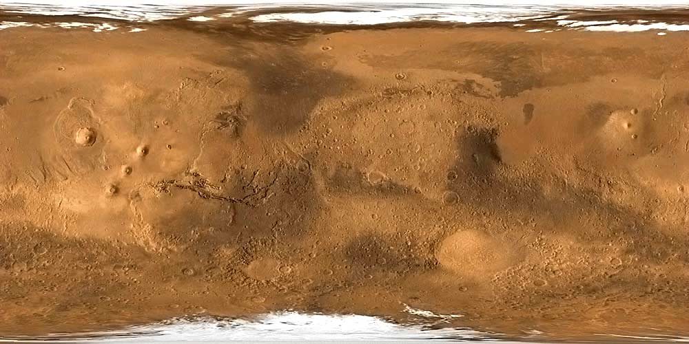
    Map of the complete surface of the planet Mars.

    We now know the surface of Mars in much greater detail than we do of the ocean floors on our own Earth.

    marssurface.jpg


  • Moderators, Social & Fun Moderators Posts: 13,571 JupiterKid
    Mod ✭✭✭✭


    Yay!! Great to see this thread I started back in its rightful place. :D

    Tongue-in-cheek map of Norn Iron. Rather accurate...

    11417_02798503_551aeff4-b5a7-4900-9b69-6c9eefb8b71e.jpeg


  • Registered Users, Registered Users 2 Posts: 14,204 Deja Boo
    ✭✭✭✭


    NP9HynO.png


  • Registered Users, Registered Users 2 Posts: 1,904 dball
    ✭✭✭


  • Nzl97EL.png


  • LKImbZv.jpg


  • JF3iLZF.png


  • Advertisement


  • UBD13wh.jpg


  • Registered Users, Registered Users 2 Posts: 35,724 NIMAN
    ✭✭✭✭


    I think that might be incorrect.


  • Registered Users, Registered Users 2 Posts: 11,161 greenspurs
    ✭✭✭✭


    [IMG][/IMG]

    Maybe a wee bit of info about what the maps are about would help ????? :confused:
    247469249_2017413731748359_7675802031635703098_n.jpg

    "Bright lights and Thunder .................... " #NoPopcorn


  • Registered Users, Registered Users 2 Posts: 14,394 Professor Moriarty
    ✭✭✭✭


    NIMAN wrote: »
    I think that might be incorrect.

    Ever so slightly. I think Partyjungle might have been partying.


  • Registered Users, Registered Users 2 Posts: 3,862 mikhail
    ✭✭✭


    greenspurs wrote: »
    Maybe a wee bit of info about what the maps are about would help ????? :confused:
    The regions of water resemble a depiction of a male sexual organ. I hope this comment was helpful to you.


  • Banned (with Prison Access) Posts: 9,078 IAMAMORON
    ✭✭✭


    Keep up the dick picks !! What a pastime. Forget Crosswords, my new hobbie is searching for Penisalikes on Googlemaps.:):pac::D


  • Registered Users, Registered Users 2 Posts: 11,161 greenspurs
    ✭✭✭✭


    NIMAN wrote: »
    I think that might be incorrect.

    I would agree!

    " Alaska is bigger than Texas, California, and Montana combined"

    https://www.alaska.org/how-big-is-alaska/texas


    :rolleyes:
    247469249_2017413731748359_7675802031635703098_n.jpg

    "Bright lights and Thunder .................... " #NoPopcorn


  • Registered Users, Registered Users 2 Posts: 16,247 Pherekydes
    ✭✭✭✭


    Lies, damned lies and maptistics!


  • Registered Users, Registered Users 2 Posts: 11,161 greenspurs
    ✭✭✭✭


    mikhail wrote: »
    The regions of water resemble a depiction of a male sexual organ. I hope this comment was helpful to you.

    Does it say more about you , or me, that I didn't spot that, but you did !! :pac: :D:D:D:P
    247469249_2017413731748359_7675802031635703098_n.jpg

    "Bright lights and Thunder .................... " #NoPopcorn


  • Advertisement
  • Closed Accounts Posts: 4,732 BarryD2
    ✭✭✭


    greenspurs wrote: »
    I would agree!

    " Alaska is bigger than Texas, California, and Montana combined"

    https://www.alaska.org/how-big-is-alaska/texas


    :rolleyes:

    Maybe, but hardly bigger than the rest of the USA and Russia combined! Not helped by the Mercator projection favoured by Google etc., which distorts area the further from the equator.


Welcome!

It looks like you're new here. Sign in or register to get started.
Advertisement