Advertisement
If you have a new account but are having problems posting or verifying your account, please email us on hello@boards.ie for help. Thanks :)
Hello all! Please ensure that you are posting a new thread or question in the appropriate forum. The Feedback forum is overwhelmed with questions that are having to be moved elsewhere. If you need help to verify your account contact hello@boards.ie

I bet you didnt know that

Options
1204205207209210334

Comments

  • Closed Accounts Posts: 5,995 ✭✭✭Ipso


    Isn’t there something in The Tain where the Conbacht army Marches toward Tara but passes Athlone which is in the opposite direction?

    I can’t remember where I read it, but this may also indicate that there were more important sites in Western Ireland (Rathcroghan in Roscommon is supposed to be very important) but groups like the UiNiall made places more associated with them more important.


  • Registered Users Posts: 9,847 ✭✭✭py2006


    Not sure if this was brought up in this thread or indeed another thread or indeed by me before! :confused:

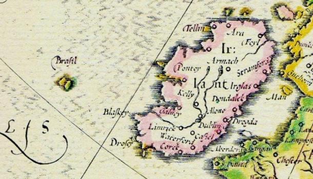
    Hy-Brasil was an island which appeared on ancient maps as early as 1325 and into the 1800s. On most maps, it was located roughly 321km (200 miles) off the west coast of Ireland in the North Atlantic Ocean. One of the most distinctive geographical features of Hy-Brasil on those maps is that it often appears as a circle with a channel (or river) running east to west across the diameter. Stories about the island have circulated throughout Europe for centuries with tales that it was the promised land of saints or a paradise where an advanced civilization lived. In Irish myth, it was said to be clouded in mist except for one day every seven years when it became visible but still could not be reached.

    Abraham_Ortelius_Map_of_Europe-e1476200464972.jpg
    Map of Abraham Ortelius 1570, cropped, showing Brasil island west of Ireland.

    Hy-Brasil.jpg?itok=TVmqv4t4

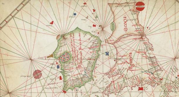
    Hy-Brasil (also called Hy-Breasal, Hy-Brazil, Hy-Breasil, Brazir) is derived from the name Breasal meaning the High King of the world in Celtic history. It was noted on maps as early as 1325, by the Genoese cartographer Angelino Dulcert where it was identified as “Bracile.” It later appeared in the Catalan Atlas in 1375, which placed it as two separate islands with the same name, “Illa de brasil”.

    Nautical-chart-of-Western-Europe.jpg?itok=0ZhR6Mn4
    The Nautical chart of Western Europe (1473) shows Hy-Brasil in a circular shape

    Researchers and archaeologists have searched in the most likely locations west of Ireland, and there is evidence that islands existed there. Shallow-water shells have been found at Porcupine Bank, somewhat northwest of the most likely location of the Irish island. Even further north, similar shells were discovered at Rockhall.

    Porcupine_Bank_and_Seabight_NE_Atlantic-765x598.png


  • Closed Accounts Posts: 2,655 ✭✭✭i57dwun4yb1pt8


    razorblunt wrote: »
    What I need to know is ... is there a name for that excited shiver thing you do when you jump in bed after a long day and pull the duvet over yourself?

    A SNOREGASM


  • Moderators, Recreation & Hobbies Moderators Posts: 16,287 Mod ✭✭✭✭quickbeam


    py2006 wrote: »
    A map created by Greek astronomer and cartographer Claudius Ptolemy, from around 140 A.D., is considered to be the oldest surviving representation of Ireland.

    MI%20PTOLEMYS%20MAP%20OF%20IRELAND%20%20c%20140%20AD.jpg

    What are the three islands in the Irish Sea?

    Isle of Man is one surely, but which, and what are the others?


  • Registered Users Posts: 21,204 ✭✭✭✭Water John


    Was the sea shallower? The sand banks off Arklow haven't any great depth.


  • Advertisement
  • Closed Accounts Posts: 7,480 ✭✭✭wexie


    quickbeam wrote: »
    What are the three islands in the Irish Sea?

    Isle of Man is one surely, but which, and what are the others?

    Isles of Scilly?
    It is likely that until relatively recent times the islands were much larger and perhaps joined together into one island named Ennor. Rising sea levels flooded the central plain around 400–500 AD, forming the current 55 islands and islets, if an island is defined as "land surrounded by water at high tide and supporting land vegetation". The word Ennor is a contraction of the Old Cornish[5] En Noer (Moer, mutated to Noer), meaning 'the land' or the 'great island'.


  • Registered Users Posts: 11,812 ✭✭✭✭sbsquarepants


    py2006 wrote: »
    A map created by Greek astronomer and cartographer Claudius Ptolemy, from around 140 A.D., is considered to be the oldest surviving representation of Ireland.

    MI%20PTOLEMYS%20MAP%20OF%20IRELAND%20%20c%20140%20AD.jpg

    Things could have been so much different if we'd just taken a little more care with that Brit magnet up near Cavan:D


  • Registered Users Posts: 5,458 ✭✭✭valoren


    Once a week, a deed poll is given to change someones middle name to 'Danger'.

    Inspired by Austin 'Danger' Powers, it turns out that Danger can be your middle name too.

    http://www.deedpoll.org.uk/AddingAMiddleName.html


  • Closed Accounts Posts: 5,995 ✭✭✭Ipso


    quickbeam wrote: »
    What are the three islands in the Irish Sea?

    Isle of Man is one surely, but which, and what are the others?

    Probably Lambay, the Romans thought that Scandinavia was an island.


  • Moderators, Sports Moderators Posts: 7,170 Mod ✭✭✭✭cdeb


    Ipso wrote: »
    Probably Lambay, the Romans thought that Scandinavia was an island.

    Kudos on not saying "Lambay island", as this would be incorrect. The "ay" at the end means "island" in Norwegian, so adding "island" in English is redundant.

    Same with Dalkey (Deilginis -> Deilg Oy, or thorn island) and Ireland's Eye (Eriu's Oy, the island where Eriu, the goddess who gives her name to Ireland, lives) - the "ey", "ay" and "eye" are all actually the Norwegian "øy", island. You can see the same etymology in the Faroes (Suđuroy = South island) and Iceland (Heimeay = Home island)


  • Advertisement
  • Closed Accounts Posts: 5,995 ✭✭✭Ipso


    A bit like saying ATM machine!


  • Registered Users Posts: 9,847 ✭✭✭py2006


    cdeb wrote: »
    Kudos on not saying "Lambay island", as this would be incorrect. The "ay" at the end means "island" in Norwegian, so adding "island" in English is redundant.

    Same with Dalkey (Deilginis -> Deilg Oy, or thorn island) and Ireland's Eye (Eriu's Oy, the island where Eriu, the goddess who gives her name to Ireland, lives) - the "ey", "ay" and "eye" are all actually the Norwegian "øy", island. You can see the same etymology in the Faroes (Suđuroy = South island) and Iceland (Heimeay = Home island)

    Tell us more about Eriu? Never heard of her and her connection to Ireland. Intriguing.


  • Closed Accounts Posts: 5,995 ✭✭✭Ipso


    From memory she was one of the Tutha de Dannan and one of three goddesses, the others being Banba and Fola.
    The Milesians invaded and defeated the Tuatha de Dannan but agreed to name the island in honor of the Tuatha De Dannan and they used the name Eriu (the name may pre-date the writing of the book of invasions) which then got changed to Eire and the island bcame known as Eireland, Normans invaded knocked of the E, welcome to Ireland.


  • Moderators, Sports Moderators Posts: 7,170 Mod ✭✭✭✭cdeb


    Not much more to add to that than a wikipedia link - https://en.m.wikipedia.org/wiki/Ériu


  • Registered Users Posts: 4,635 ✭✭✭donegal.


    Ipso wrote: »
    From memory she was one of the Tutha de Dannan and one of three goddesses, the others being Banba and Fola.

    I don't know anything about Fola, but Banba's crown is Irelands most northerly point.


  • Closed Accounts Posts: 5,995 ✭✭✭Ipso


    donegal. wrote: »
    I don't know anything about Fola, but Banba's crown is Irelands most northerly point.

    That's right.
    I think there is an Irish navy ship named after all three.
    Looks like there was an old Pictish kingdom named after Fodhla.
    https://en.wikipedia.org/wiki/Atholl


  • Registered Users Posts: 761 ✭✭✭Foggy Jew


    wexie wrote: »

    What are the goats called on the Isles of Scilly?

    Why!!! The Scilly Billies, of course!! (I'll get my coat).

    It's the bally ballyness of it that makes it all seem so bally bally.


  • Moderators, Recreation & Hobbies Moderators, Science, Health & Environment Moderators, Technology & Internet Moderators Posts: 90,966 Mod ✭✭✭✭Capt'n Midnight


    Water John wrote: »
    Was the sea shallower? The sand banks off Arklow haven't any great depth.
    There were islands in the North Sea perhaps as recently as Viking times.


  • Closed Accounts Posts: 5,995 ✭✭✭Ipso


    Foggy Jew wrote: »
    What are the goats called on the Isles of Scilly?

    Why!!! The Scilly Billies, of course!! (I'll get my coat).

    Gruff!


  • Moderators, Recreation & Hobbies Moderators, Science, Health & Environment Moderators, Technology & Internet Moderators Posts: 90,966 Mod ✭✭✭✭Capt'n Midnight


    ^^^^

    Don't feed the troll.


  • Advertisement
  • Registered Users Posts: 5,181 ✭✭✭Lady Haywire


    ^^^^

    Don't feed the troll.

    Oh build a bridge and get over it!


  • Registered Users Posts: 3,605 ✭✭✭Kat1170


    Oh build a bridge and get over it!

    Your plan is to build a bridge, when there is a Troll about ?? Really ??


  • Registered Users Posts: 5,181 ✭✭✭Lady Haywire


    Kat1170 wrote: »
    Your plan is to build a bridge, when there is a Troll about ?? Really ??

    Well as we already have the goats, they just need to lure him in!


  • Registered Users Posts: 969 ✭✭✭Greybottle


    This building in Buenos Aires is the Kavanagh Building, named after Corina Kavanagh, a farmer and businesswoman of Irish descent. She built it out of spite after her fiances family forced him to split from her as she was 'new money' and they were 'old money'. She was 39 at the time. The building was positioned so that the family would not be able to see a church that the built from their house.

    When constructed it was the highest building in the Americas south of Texas. It is still one of the greatest Art Deco buildings on the planet and is one of the most ingeniouis buildings built at the time, or indeed any time.

    There's an excellent 3D view of it on Google Streetview Here: https://www.google.ie/maps/dir/-34.5950504,-58.3746481/-34.5955467,-58.3750077/@-34.5942121,-58.3746754,208a,35y,180h,39.48t/data=!3m1!1e3!4m2!4m1!3e2


    And there#s some more reading on it here: https://en.wikiarquitectura.com/building/kavanagh-building/ and here: https://argentinatraveler.wordpress.com/2011/08/02/the-legend-of-the-kavanagh-building-in-buenos-aires/


    afac1bd35d892fab7b82391044bf6988.jpg

    There's also an excellent arrticle in todays Guardian about spite buildings here: https://www.theguardian.com/cities/2018/jun/21/spite-buildings-when-human-grudges-get-architectural-in-pictures


  • Registered Users Posts: 8,375 ✭✭✭Gloomtastic!


    Speaking of spite buildings, we have here in Dublin 3, Marino Crescent, also known as Spite Crescent.
    The Crescent was built by plumber/builder Charles Ffolliot to block the sea view from Lord Charlemont’s Marino House because he objected to having to pay a toll to his Lordship every time he used, what is now, the Malahide Road.
    Bram Stoker, of Dracula fame, lived at no. 15, Marino Crescent.

    https://goo.gl/images/jCvXFR


  • Registered Users Posts: 11,812 ✭✭✭✭sbsquarepants


    The Jealous wall in Belvedere House, Lough Ennel - Irelands biggest folly. Looks like a gothic ruin, but is actually just a wall in a field, it has a gruesomely fascinating story behind it. Built by a very nasty piece of work, Robert Rochfort aka the Wicked Earl, so that he wouldn't have to look at his brothers house which was bigger!

    http://atriptoireland.com/2013/10/23/the-sordid-tale-behind-the-jealous-wall/

    belvedere-jealous-wall.jpg


  • Moderators, Arts Moderators, Recreation & Hobbies Moderators, Social & Fun Moderators Posts: 76,630 Mod ✭✭✭✭New Home


    I'm almost sure it was built because he didn't want his brother and his wife to look at each other. He was a veritable tyrant.


  • Registered Users Posts: 11,812 ✭✭✭✭sbsquarepants


    Possibly, it's been a while since I was there. He was an out an out tyrant.

    Camped on the grounds with the kids for a weekend a few years back - bugger all to do there, but it's a lovely place just to chill for a bit!


  • Registered Users Posts: 21,522 ✭✭✭✭Tell me how


    The Jealous wall in Belvedere House, Lough Ennel - Irelands biggest folly. Looks like a gothic ruin, but is actually just a wall in a field, it has a gruesomely fascinating story behind it. Built by a very nasty piece of work, Robert Rochfort aka the Wicked Earl, so that he wouldn't have to look at his brothers house which was bigger!

    The first sentence of the body of the piece in the weblink states "It all started in 1936".

    I therefore denounce the entire piece as fake News.


  • Advertisement
  • Registered Users Posts: 11,812 ✭✭✭✭sbsquarepants


    The first sentence of the body of the piece in the weblink states "It all started in 1936".

    I therefore denounce the entire piece as fake News.

    I assume they mean 1736!:D


This discussion has been closed.
Advertisement