Advertisement
If you have a new account but are having problems posting or verifying your account, please email us on hello@boards.ie for help. Thanks :)
Hello all! Please ensure that you are posting a new thread or question in the appropriate forum. The Feedback forum is overwhelmed with questions that are having to be moved elsewhere. If you need help to verify your account contact hello@boards.ie

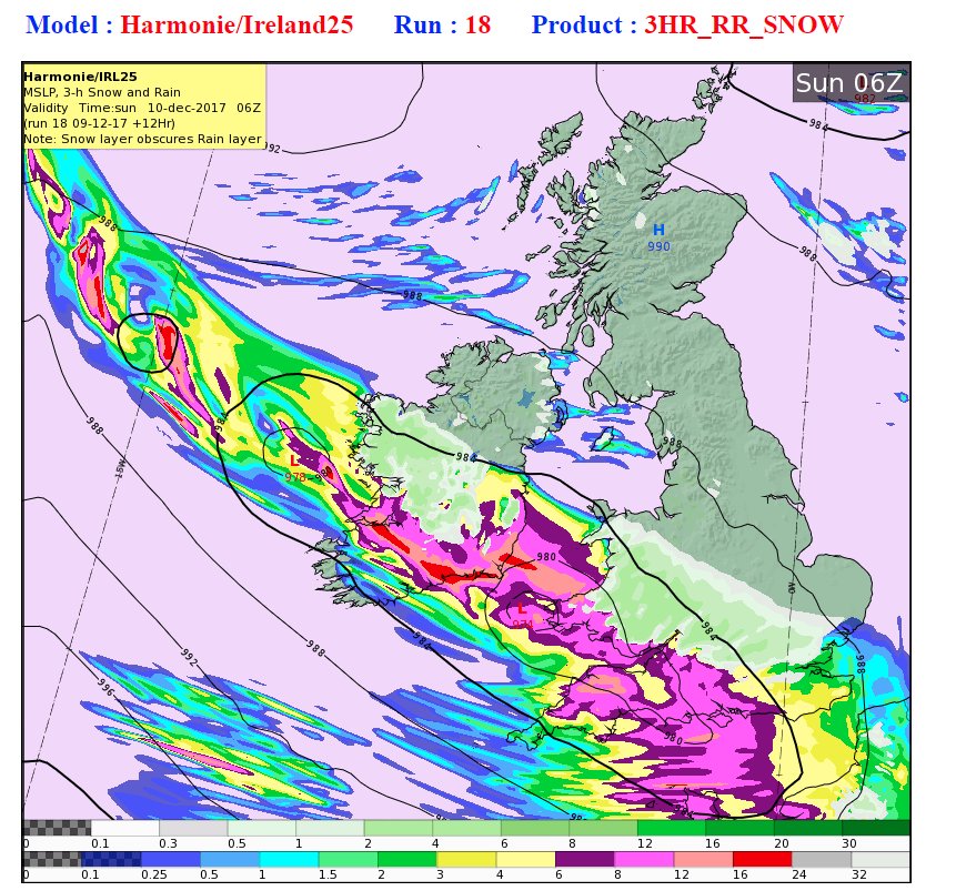
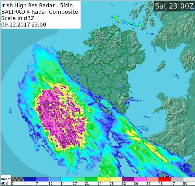
Snow and Ice Warning : Saturday(PM)/Sunday 9th/10th December - SEE MOD NOTE POST #1

Options
1282931333474

Comments

  • Registered Users Posts: 10,102 ✭✭✭✭Oscar Bravo


    Sure sounds like it!

    B39_FB4_BB_A886_4_FC4_8_C89_41_BAE00714_FC.jpg

    that must of been some day in June 76! clear blue skies, fields cut, tar melting. nice records.


  • Registered Users Posts: 10,102 ✭✭✭✭Oscar Bravo


    2313 Met Update

    Further heavy rain over Munster tonight with a risk of local flooding.
    A mixture of heavy rain and heavy snow will extend over Connacht and Leinster, and it will stay mostly dry for Ulster. Lowest temperatures from +6 degrees in the south to generally between 0 and minus 6.
    Moderate to fresh southeasterly winds for most but strong to gale force westerly winds will affect western and southern coastal areas by dawn and continue over Munster for a time Sunday morning.


    Tomorrow

    Sunday:
    A further mixture of heavy rain, sleet and snow on Sunday will cause dangerous and disruptive conditions in places.
    Clearer weather over Ulster will gradually extend southwards during the afternoon and evening.
    Daytime temperatures will range zero to 7 degrees but a severe frost and icy conditions will set in quickly to all areas Sunday evening.

    Outlook

    Sunday night: A widespread severe air and ground frost will result in dangerous icy conditions on untreated surfaces. Minimum temperatures -2 to -8 degrees.


  • Registered Users Posts: 19,306 ✭✭✭✭Drumpot


    It’s funny cause I live on the coast of Meath (Bettystown) and we never get any decent snow but the BBC weather forecast made it look like we are going to get pummeled! I came straight here and MTCranium quickly put paid to those delusions of Grandeur, in a good way... I always value the updates from this forum....


  • Registered Users Posts: 1,349 ✭✭✭GhostyMcGhost


    that must of been some day in June 76! clear blue skies, fields cut, tar melting. nice records.

    Yeah I’d say in Thomastown 82 you’d be wishing for 76 again when your standing out in a field, freezing your nads off trying to get the cows into a barn


  • Registered Users Posts: 8,913 ✭✭✭Danno


    DQpCDzrWkAAi670.jpg


  • Advertisement
  • Registered Users Posts: 6,102 ✭✭✭TheRiverman


    Breeze/wind has picked up significantly here in West Offaly,no rain or snow yet.


  • Registered Users Posts: 10,102 ✭✭✭✭Oscar Bravo


    11pm reports

    Knock -1
    Markree(sligo) -1
    Ballyhaise -1

    (Sherkin islands 9 degrees)


  • Registered Users Posts: 8,543 ✭✭✭Speak Now


    Sure sounds like it!

    B39_FB4_BB_A886_4_FC4_8_C89_41_BAE00714_FC.jpg

    Does that weather station still exist. I know Met Eireann replaced with with Oak park. Got to Urban i think.

    Lashing in Waterford now 7c.


  • Registered Users Posts: 234 ✭✭konman


    Just started raining here with an odd bit of schleet thrown in.
    5 miles south of Tuam


  • Registered Users Posts: 1,509 ✭✭✭Hooter23


    The Snow has arrived in Galway cant wait to build one these tomorrow:)

    images?q=tbn:ANd9GcTCp5lz4ai99Ho0mU885383ReenuC3Cr3WtrXMHhPdb2HZnsK-idg


  • Advertisement
  • Registered Users Posts: 8,913 ✭✭✭Danno


    DQo_BPBXUAIJeYJ.jpg


  • Posts: 0 [Deleted User]


    that must of been some day in June 76! clear blue skies, fields cut, tar melting. nice records.
    I remember that day in Kilkenny!! It was the hottest day in a long hot Summer :) - we haven't had a Summer like it since.


  • Registered Users Posts: 18,141 ✭✭✭✭JCX BXC


    5.4mm so far here in West Clare, rate of 8.8mm/h, if this was snow I don't think I'd be leaving the house for a while!


  • Banned (with Prison Access) Posts: 3,288 ✭✭✭mickmackey1


    Lashing rain in mid-Limerick too.


  • Registered Users Posts: 674 ✭✭✭eastmayo


    11pm reports

    Knock -1
    Markree(sligo) -1
    Ballyhaise -1

    (Sherkin islands 9 degrees)

    Looks like the rain sleet near castlebar?


  • Registered Users Posts: 14,408 ✭✭✭✭M.T. Cranium


    The 18z Arpege shows a scenario in which rain that spreads over most of the eventual snowfall zone changes to snow hour by hour with the snow beginning to prevail over most central and inland southeast counties by 0600h, then the second low looks quite promisingly deep (976 mbs) and it may become the focus of some exceptionally heavy snowfalls further west than some might be expecting, like from Galway south and southeast to Limerick. That stage would come around mid-day Sunday with the rest of the snowfall zone in light to moderate snow, always edging further south.

    The main problem for Meath is being too far north rather than too mild, except along the coast it's both problems. If those can be overcome by some extension of the precip shield co-operating with a lack of inflow of Irish Sea surface layer warming, then Meath could see 5 cms.

    Here are my best guesses county by county:

    Galway and Roscommon -- 10-15 cm south, 5-10 cm north
    Mayo, Sligo and Leitrim -- 2-5 cm southern portions, trace to 2 cm north
    (most of Ulster will only get localized flurries outside the storm zone, southern boundaries could see 1-2 cm)

    Clare -- 5 to 10 cm except 2 to 5 cm southwest of Ennis
    Limerick -- 8 to 12 cm
    Kerry -- snow only on higher terrain
    Cork -- some northern parts 5 cm, south see Kerry
    Tipps -- 10 to 15 cm
    Waterford -- 5 to 10 cm on some northern hills, trace to 3 cm south
    Wexford -- 5 to 10 cm well inland, trace to 3 cm near coast
    Carlow, Laois, Kilkenny -- 10 to 20 cm, potential for 30 cm on higher ground
    Wicklow -- 10 to 20 cm west of higher ground, and on some east-facing slopes above 200m, trace to 3 cm coastal
    Kildare, Offaly, south Westmeath, southwest Meath, western co. Dublin -- 15 to 25 cm, risk of freezing rain mixing in
    Longford -- 5 to 10 cm (15 cm south possibly)
    Dublin -- wide variations from zero near shoreline to 10 cm on higher parts of city
    Meath -- gradual reduction from 20 cm southwest corner to 5 cm central to near zero coastal
    Louth -- likely to be outside snowfall zone but potentially could see 2-3 cm.

    Apologies if I overlooked your county


  • Registered Users Posts: 10,102 ✭✭✭✭Oscar Bravo


    Latest Rain will become latest Snow further North later, a set up like this is fairly rare , to those who get Snow photos please!

    DQo_BPBXUAIJeYJ.jpg:large


  • Closed Accounts Posts: 9,586 ✭✭✭4068ac1elhodqr


    More green appearing now, let it snow.

    Screen_Shot_2017-12-09_at_23.39.21.pngScreen_Shot_2017-12-09_at_23.39.58.png


  • Posts: 0 [Deleted User]


    Carlow, Laois, Kilkenny -- 10 to 20 cm, potential for 30 cm on higher ground

    Apologies if I overlooked your county

    One more sleep:D!!!


  • Registered Users Posts: 48,176 ✭✭✭✭km79


    Oh lordee
    Not looking forward to the drive from Shannon. To Athenry tomorrow


  • Advertisement
  • Registered Users Posts: 19,402 ✭✭✭✭road_high


    Speak Now wrote: »
    Does that weather station still exist. I know Met Eireann replaced with with Oak park. Got to Urban i think.

    Lashing in Waterford now 7c.

    Yea it was moved to Oakpark in 2008.


  • Registered Users Posts: 8,061 ✭✭✭irishfeen


    Here are my best guesses county by county:

    Cork -- some northern parts 5 cm, south see Kerry

    Apologies if I overlooked your county

    5cm in northern areas of Cork County would be significant, especially if we got anything like that as far south as Mallow Town - a very rare event indeed if it was to come through.


  • Registered Users Posts: 768 ✭✭✭davidsr20


    Sleet here now. Craughwell Galway.


  • Registered Users Posts: 5,565 ✭✭✭Pangea


    This thread is a hard read for those of us in Donegal. Enjoy your snow guys, looks epic.


  • Closed Accounts Posts: 3,502 ✭✭✭q85dw7osi4lebg


    Zero wind, fog, light frost.

    Coastal Meath.


  • Registered Users Posts: 6,948 ✭✭✭pauldry


    According to snowdar its now snowing on hills in galway mayo n sleeting everywhere else that precipitation is falling in much of these counties. Minus 6 wasnt reached.


  • Registered Users Posts: 590 ✭✭✭chelseavera


    Very VERY light snow here in North Mayo now. Result - as it's not been preceded by rain. It'll stick if (when!) it gets heavier!


  • Registered Users Posts: 497 ✭✭loughside


    Hi all, you may have this site already but it`s been a good radar one for me lately, updates every 10 mins or so.
    https://www.netweather.tv/live-weather/radar


  • Registered Users Posts: 2,005 ✭✭✭squarecircles


    Beginning to turn sleety here in West Mayo, feels Baltic outside in the wind


  • Advertisement
  • Closed Accounts Posts: 6,751 ✭✭✭mirrorwall14


    The 18z Arpege shows a scenario in which rain that spreads over most of the eventual snowfall zone changes to snow hour by hour with the snow beginning to prevail over most central and inland southeast counties by 0600h, then the second low looks quite promisingly deep (976 mbs) and it may become the focus of some exceptionally heavy snowfalls further west than some might be expecting, like from Galway south and southeast to Limerick. That stage would come around mid-day Sunday with the rest of the snowfall zone in light to moderate snow, always edging further south.

    The main problem for Meath is being too far north rather than too mild, except along the coast it's both problems. If those can be overcome by some extension of the precip shield co-operating with a lack of inflow of Irish Sea surface layer warming, then Meath could see 5 cms.

    Here are my best guesses county by county:

    Galway and Roscommon -- 10-15 cm south, 5-10 cm north
    Mayo, Sligo and Leitrim -- 2-5 cm southern portions, trace to 2 cm north
    (most of Ulster will only get localized flurries outside the storm zone, southern boundaries could see 1-2 cm)

    Clare -- 5 to 10 cm except 2 to 5 cm southwest of Ennis
    Limerick -- 8 to 12 cm
    Kerry -- snow only on higher terrain
    Cork -- some northern parts 5 cm, south see Kerry
    Tipps -- 10 to 15 cm
    Waterford -- 5 to 10 cm on some northern hills, trace to 3 cm south
    Wexford -- 5 to 10 cm well inland, trace to 3 cm near coast
    Carlow, Laois, Kilkenny -- 10 to 20 cm, potential for 30 cm on higher ground
    Wicklow -- 10 to 20 cm west of higher ground, and on some east-facing slopes above 200m, trace to 3 cm coastal
    Kildare, Offaly, south Westmeath, southwest Meath, western co. Dublin -- 15 to 25 cm, risk of freezing rain mixing in
    Longford -- 5 to 10 cm (15 cm south possibly)
    Dublin -- wide variations from zero near shoreline to 10 cm on higher parts of city
    Meath -- gradual reduction from 20 cm southwest corner to 5 cm central to near zero coastal
    Louth -- likely to be outside snowfall zone but potentially could see 2-3 cm.

    Apologies if I overlooked your county

    MT Cranium may I ask about the Kildare forecast. Here in north Kildare and some of the models look like we may be missed entirely but you have 15-20cm? I’m on the hoping for snow bandwagon but just curious as to the discrepancy between posters saying we may miss out and yours. I’ve been around long enough to trust your forecasting and be jumping for joy at this particular one when I was on the downer section of the rollercoaster


Advertisement