Advertisement
Help Keep Boards Alive. Support us by going ad free today. See here: https://subscriptions.boards.ie/.
If we do not hit our goal we will be forced to close the site.

Current status: https://keepboardsalive.com/

Annual subs are best for most impact. If you are still undecided on going Ad Free - you can also donate using the Paypal Donate option. All contribution helps. Thank you.
https://www.boards.ie/group/1878-subscribers-forum

Private Group for paid up members of Boards.ie. Join the club.

Interesting Maps

1371372374376377380

Comments

  • Moderators, Category Moderators, Arts Moderators, Sports Moderators, Paid Member Posts: 54,290 CMod ✭✭✭✭magicbastarder


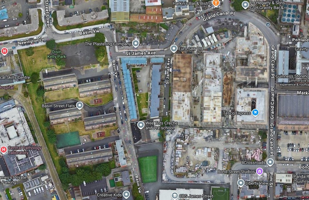
    why did grand canal place in the liberties get called that when it's over 1km from the grand canal?

    image.png


  • Registered Users, Registered Users 2, Paid Member Posts: 9,859 ✭✭✭blackwhite


    There used be a spur of the Grand Canal into there that Guinness (amongst others) used in the past.

    The Luas runs along much of the old canal route.

    EDIT - it was actually the original, and the loop to Grand Canal Dock was the spur.

    https://irishwaterwayshistory.com/abandoned-or-little-used-irish-waterways/waterways-in-dublin/the-abandoned-main-line-of-the-grand-canal-4/


  • Moderators, Category Moderators, Arts Moderators, Sports Moderators, Paid Member Posts: 54,290 CMod ✭✭✭✭magicbastarder


    yeah, that makes sense - i used to live in phibsboro and was well aware of the spur (from the royal canal) that led to blessington basin, so i should have thought of that possibility.


  • Registered Users, Registered Users 2 Posts: 269 ✭✭ath262


    There was a side branch of the canal that lead to a harbour there
    1912 Map extract from Dublin Historic Maps : https://www.dublinhistoricmaps.ie/maps/1900-1939/index.html

    The Luas line now follows part of the route of the old canal link

    image.png


  • Registered Users, Registered Users 2 Posts: 1,250 ✭✭✭vincenzolorenzo


    This exactly! My abiding memory when we all saw them first was how small the coins were. If you saw an old Irish coin now you would think they were massive, especially the £1. No one in the real world in ROI called them punts. Shopkeeper didn't say that's 3 punts please. Can see how the term would have been used in border region, but don't live there. Only time I ever really heard it was on the news if they were talking about currency and to distinguish from STG. Big news mid 90s when the value of the IR£ currency exceeded STG for the first time. That, and making USA 94 when England didn't, jaysus we thought we were great altogether 😂


  • Advertisement
  • Registered Users, Registered Users 2 Posts: 526 ✭✭✭Mr_A


    It absolutely was where I grew up, possibly because it was near the border but it was used a lot more than pound ever was


  • Registered Users, Registered Users 2 Posts: 269 ✭✭ath262


    same here - work involved travelling across the border frequently so a constant mix of Punts and STG
    Businesses just across the border had signs re he latest rate, e.g. the Offie near Carrigarnan (sp?) crossing


  • Registered Users, Registered Users 2, Paid Member Posts: 5,147 ✭✭✭Rawr


    And, we were in the middle of the Eurovision hat-trick too. Fun times…


  • Registered Users, Registered Users 2 Posts: 8,041 ✭✭✭GerardKeating


    It is in no way revisionist to claim that the term punt was not used in English speaking Ireland. It was of course more common in area that handled both "pounds" where one needed to be clear which currency was under discussion.


  • Registered Users, Registered Users 2, Paid Member Posts: 5,147 ✭✭✭Rawr


    CityBasin.jpg

    The Grand Canal Harbor and the nearby City Basin (to the left) still leave a footprint on the street layout today. Both have since been filled in and built upon.


  • Advertisement
  • Registered Users, Registered Users 2 Posts: 882 ✭✭✭minggatu


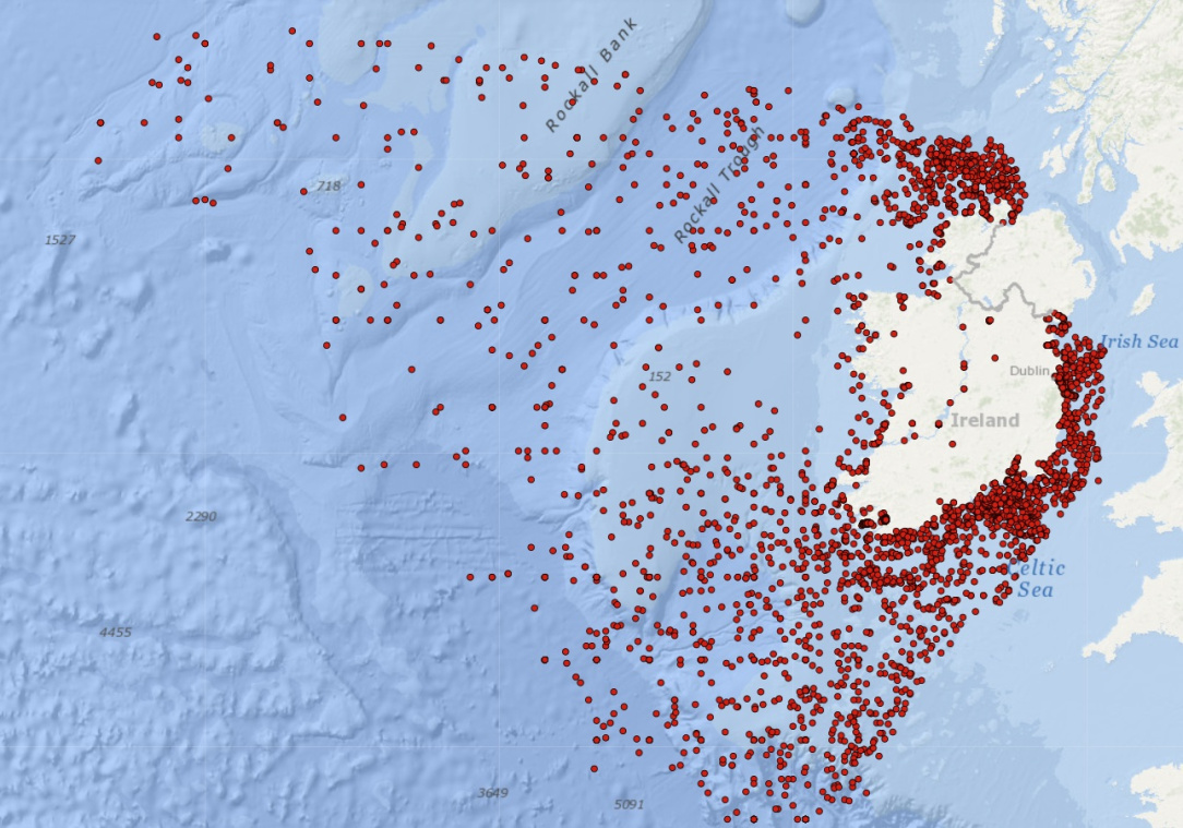
    Map Of 3,554 Shipwrecks Around Ireland Going Back To 1530

    irish-wrecks.jpg

    Map taken from the National Monuments Service: Wreck Viewer

    The map above shows the location of 3,554 Shipwrecks Around Ireland where the location is known going all the way back to 1530. About their database:

    [Read more…]


  • Moderators, Sports Moderators Posts: 7,544 Mod ✭✭✭✭cdeb


    The RMS Tayleur is one I was reading about recently - sunk off Lambay on its maiden voyage in 1854 en route from Liverpool to Australia. 370 of 650 on board died - almost all of the survivors were men, who could climb the cliffs to safety. Children were too weak and women were weighed down by the layers of clothing they wore in those days.

    As ever there were multiple causes - but the main one was that the compass was following the ship's iron hull... So it led them straight across the Irish Sea when they thought they were going south, and heavy fog meant they didn't see Lambay until it was too late.

    An early Titanic - they were even both operated by the White Star Line

    Post edited by cdeb on


  • Registered Users, Registered Users 2 Posts: 882 ✭✭✭minggatu


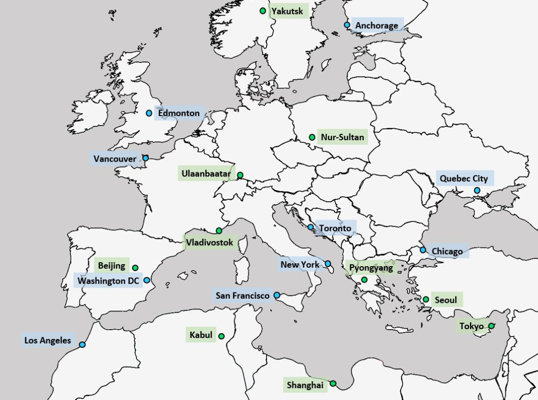
    Comparing the latitudes of major world cities with Europe

    G21txTcasAACYBa.jpg

    https://x.com/amazingmap/status/1976356507274052058/photo/1


  • Registered Users, Registered Users 2 Posts: 882 ✭✭✭minggatu


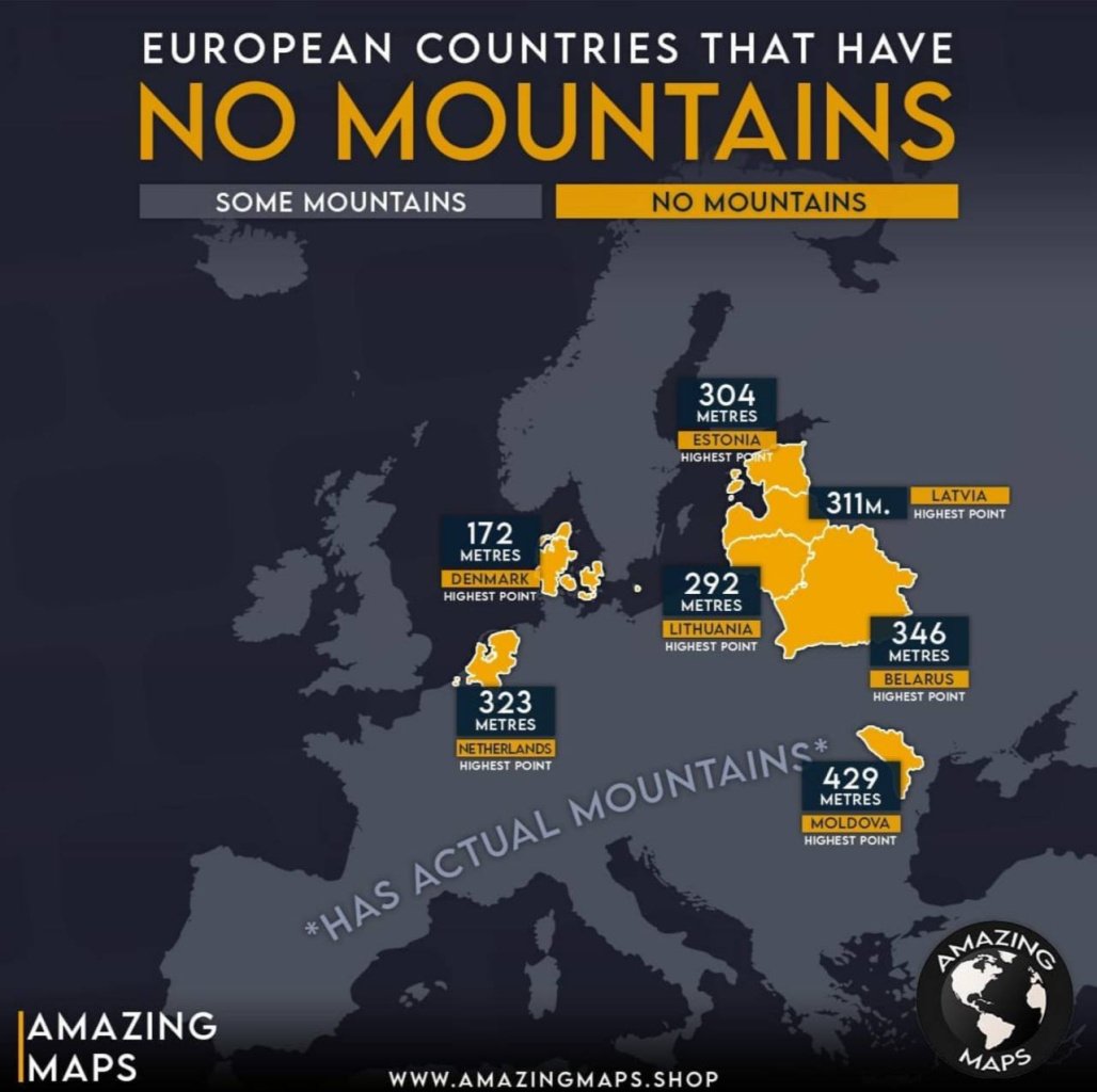
    European Countries With No Mountains No-mountains.jpg

    Map created by Amazing__Maps

    The map above shows which European countries have some mountains and which has no mountains.

    Mountains here is being defined as: “usually higher than a hill, typically rising at least 600 metres (2,000 ft) above the surrounding land.”


  • Registered Users, Registered Users 2 Posts: 882 ✭✭✭minggatu


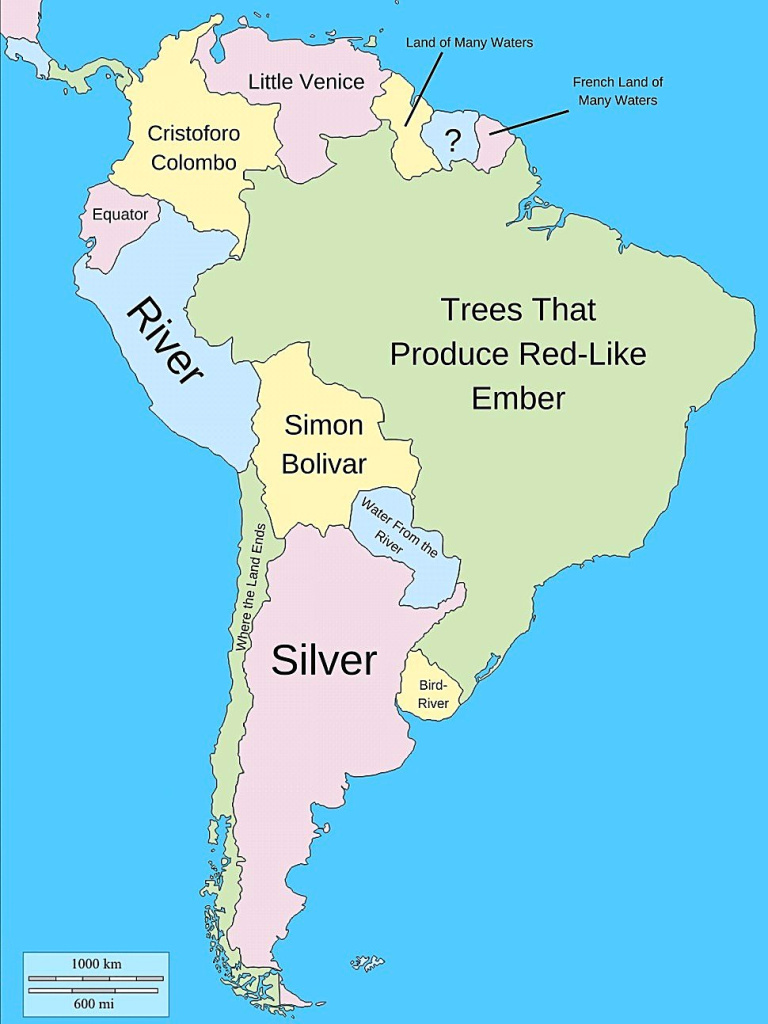
    The literal meanings of South American country names

    G203FI7aAAAXo32.jpg

    https://x.com/amazingmap/status/1976296374753951809/photo/1


  • Moderators, Social & Fun Moderators, Paid Member Posts: 14,032 Mod ✭✭✭✭JupiterKid


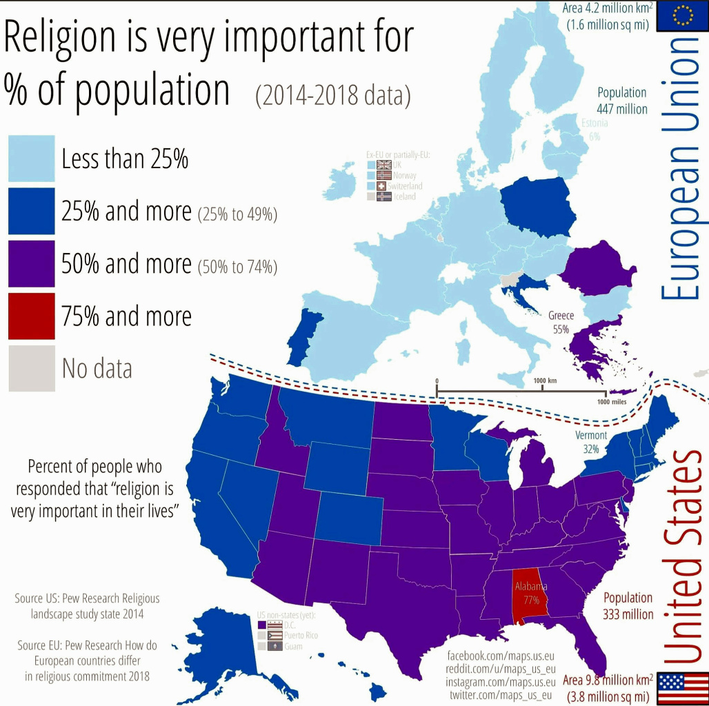
    Comparison between EU and USA in terms of importance of religion, 2014-2018

    FB_IMG_1760195544301.jpg

    Note the stark difference between the EU and USA. There is also an inverse relationship between educational attainment, wealth and religious belief.


  • Registered Users, Registered Users 2 Posts: 1,471 ✭✭✭Busman Paddy Lasty


    Crazy that there was a canal viaduct over the road to Broadstone as well. I'll check now but The Broadstone Harbour is probably filled in too.

    Edit: yes filled in. The aqueduct (not viaduct) was called Foster's Aqueduct.

    1000001141.jpg


  • Registered Users, Registered Users 2, Paid Member Posts: 5,147 ✭✭✭Rawr


    Fantastic read on that. Had no idea the Royal Canal had an abandoned stretch all the way down to Broadstone. The streetnames around there are starting to make a lot more sense :P


  • Registered Users, Registered Users 2 Posts: 32,485 ✭✭✭✭zell12


    Eastern Canada currently drought-stricken

    image.png


  • Registered Users, Registered Users 2 Posts: 882 ✭✭✭minggatu


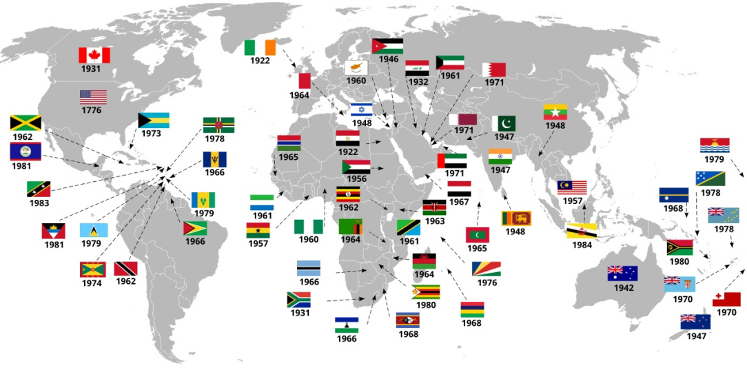
    Map of All Countries That Have Ever Gained Independence From The United Kingdom List_of_countries_gained_independence_from_the_UK.jpg

    https://brilliantmaps.com/gained-independence-uk/


  • Advertisement
  • Registered Users, Registered Users 2 Posts: 4,435 ✭✭✭Brief_Lives


    Oz got independence in the middle of world war 2?

    That's mad Ted


  • Registered Users, Registered Users 2 Posts: 14,887 ✭✭✭✭joujoujou
    Unregistered Users


    Well, it's complicated:

    • 1901: Federation: The six separate British colonies united as the Commonwealth of Australia on January 1, 1901. The Commonwealth of Australia Constitution Act 1900, passed by the British Parliament, enabled this federation. At this point, Australia had its own government but was still under the British Crown.
    • 1931: Statute of Westminster: This legislation gave Commonwealth countries legislative independence, but Australia did not adopt it until 1942.
    • 1986: Australia Act: The Australia Act 1986 formally severed the last links with the British Parliament, marking the final step in Australia's journey to full independence. It ended the ability of the UK Parliament to legislate for Australia and abolished the right of appeal to the Judicial Committee of the Privy Council. 


  • Registered Users, Registered Users 2 Posts: 6,549 ✭✭✭yagan


    Oz, Nz and Canada are still British realms.

    When I lived in Oz it was very jarring how attached to the old country it was. I remember a survey asking the public what precentege did they reckon Britain accounted for Aus exports, and most said about 30%, when the actually number was somewhere around 4%.

    Conversely the public vastly underestimated how much Oz exported to China.

    The other thing that irked was they'd call me an ex-pat, whereas my colleagues from Asia on the same wages and visas were called immigrants.


  • Moderators, Social & Fun Moderators, Paid Member Posts: 14,032 Mod ✭✭✭✭JupiterKid


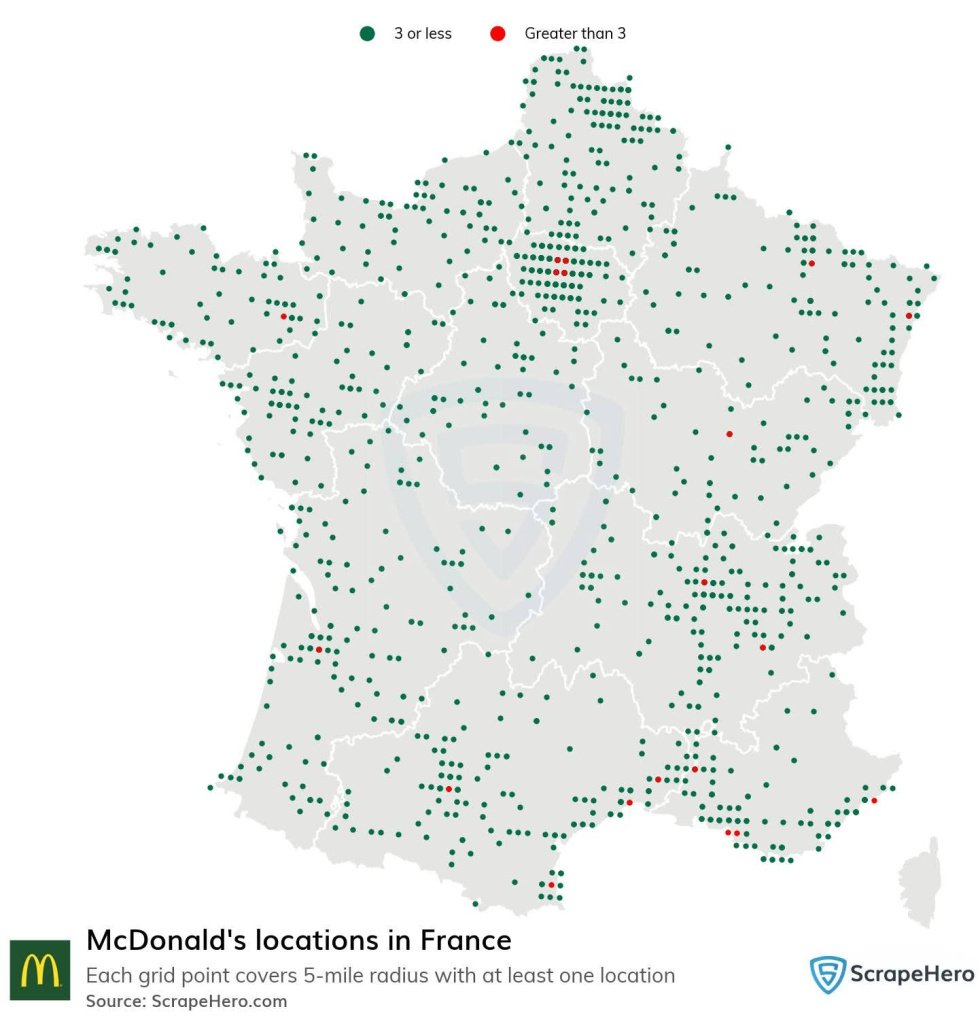
    Location of the 1,400+ McDonald's outlets in France.

    FB_IMG_1760005794962.jpg

    The first McDonald's in France opened in Paris in 1972. However, the initial franchise was badly run and the first outlets closed in 1976. McDonald's subsequently reopened in Strasbourg in 1979 and expanded rapidly in France since then.


  • Registered Users, Registered Users 2 Posts: 32,485 ✭✭✭✭zell12


    L'Corse sans McDo!


  • Registered Users, Registered Users 2 Posts: 269 ✭✭ath262


    Map extract from dublinhistoricmaps.ie, showing the aqueduct on an 1819 map (the OSI links in article are out of date)

    image.png


  • Registered Users, Registered Users 2 Posts: 62 ✭✭Hasbaralies


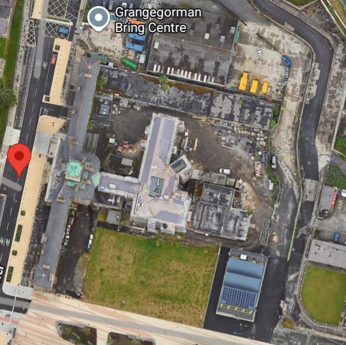
  • Registered Users, Registered Users 2 Posts: 1,471 ✭✭✭Busman Paddy Lasty


    Brilliant! A penitentiary and not one but two asylums. I'm guessing what is now on maps as The Clock Tower building is the western elevation of the penitentiary.

    1000001152.jpg
    Post edited by Busman Paddy Lasty on


  • Registered Users, Registered Users 2, Paid Member Posts: 28,179 ✭✭✭✭Peregrinus


    Oz, NZ and Canada are Commonwealth realms. There are 15 Commonwealth realms in all (of which the UK itself is one).

    In Australian usage, an expat is someone living and working in Australia, but who expects, or is expected, to return to their country of origin. An immigrant is understood to be permanently settled. The "Pommie migrant" is a well-established stereotype in Australia, and he is definitely not an expat.

    Nowadays, the UK accounts for just 2.3% of Australian exports, just behind Vietnam (2.5%) and ahead of Malaysia (1.9%). I don't know how long it is since you lived in Australia, but I don't get the impression nowadays that many people think of the UK as a significant export market.


  • Advertisement
  • Registered Users, Registered Users 2 Posts: 503 ✭✭✭Mullinabreena


Advertisement