Advertisement
If you have a new account but are having problems posting or verifying your account, please email us on hello@boards.ie for help. Thanks :)
Hello all! Please ensure that you are posting a new thread or question in the appropriate forum. The Feedback forum is overwhelmed with questions that are having to be moved elsewhere. If you need help to verify your account contact hello@boards.ie

Interesting Maps

1336337338339340342»

Comments

  • Registered Users, Registered Users 2 Posts: 15,006 ✭✭✭✭retalivity


    Language map from 1887

    FB_IMG_1749068515524.jpg


  • Moderators, Social & Fun Moderators Posts: 13,631 Mod ✭✭✭✭JupiterKid


    GSI Blue Scale Series topographic/bathymetry map of Bantry Bay and coastal West Cork

    Bantry.jpeg


  • Moderators, Social & Fun Moderators Posts: 13,631 Mod ✭✭✭✭JupiterKid


    Coup d'etats and coup attempts in Europe since 1945

    number-of-coup-dtats-attempts-in-europe-since-1945.jpg


  • Moderators, Social & Fun Moderators Posts: 13,631 Mod ✭✭✭✭JupiterKid


    Space programmes ranked on level of development by country, 2024

    most-advanced-space-programs-by-country.jpg


  • Moderators, Social & Fun Moderators Posts: 13,631 Mod ✭✭✭✭JupiterKid


    Master plan of Milton Keynes new city, 1969

    milton-keynes-Q-1600x942.jpg


  • Advertisement
  • Registered Users, Registered Users 2 Posts: 11,323 ✭✭✭✭Tom Mann Centuria


    SO MANY roundabouts. Here's just a small selection.

    1000016734.gif

    Oh well, give me an easy life and a peaceful death.


  • Registered Users, Registered Users 2 Posts: 2,073 ✭✭✭Slideways


    My old man grew up in London. I told him I have a new work colleague from Milton Keynes. He is of the era that nobody is “from” Milton Keynes, he must have moved there


  • Moderators, Social & Fun Moderators Posts: 13,631 Mod ✭✭✭✭JupiterKid


    Eruption of Mount Etna in Sicily, captured yesterday (June 4th 2025) by the European Space Agency's (ESA) Copernicus Sentinel-5P satellite.

    Mount Etna Eruption May 2025 1.jpg

    This new eruption has involved massive plumes of ash and smoke, with extensive lava flows streaking down the side of the volcano. The ash cloud has risen to a height of 6,500 metres (21,000 feet) almost twice as high as Mount Etna itself, standing at 3,350 metres (11,000 feet).


  • Registered Users, Registered Users 2 Posts: 669 ✭✭✭minggatu


    Parliament seating arrangements in different countries worldwide. 9kzzwatuxx4f1.jpeg


  • Registered Users, Registered Users 2 Posts: 30,663 ✭✭✭✭zell12


    The world's largest island-in-a-lake-on-an-island-in-a-lake-on-an-island 😃

    image.png image.png


  • Advertisement
  • Registered Users, Registered Users 2 Posts: 14,338 ✭✭✭✭joujoujou
    Unregistered Users


    ..

    Untitled Image


  • Registered Users, Registered Users 2 Posts: 11,323 ✭✭✭✭Tom Mann Centuria


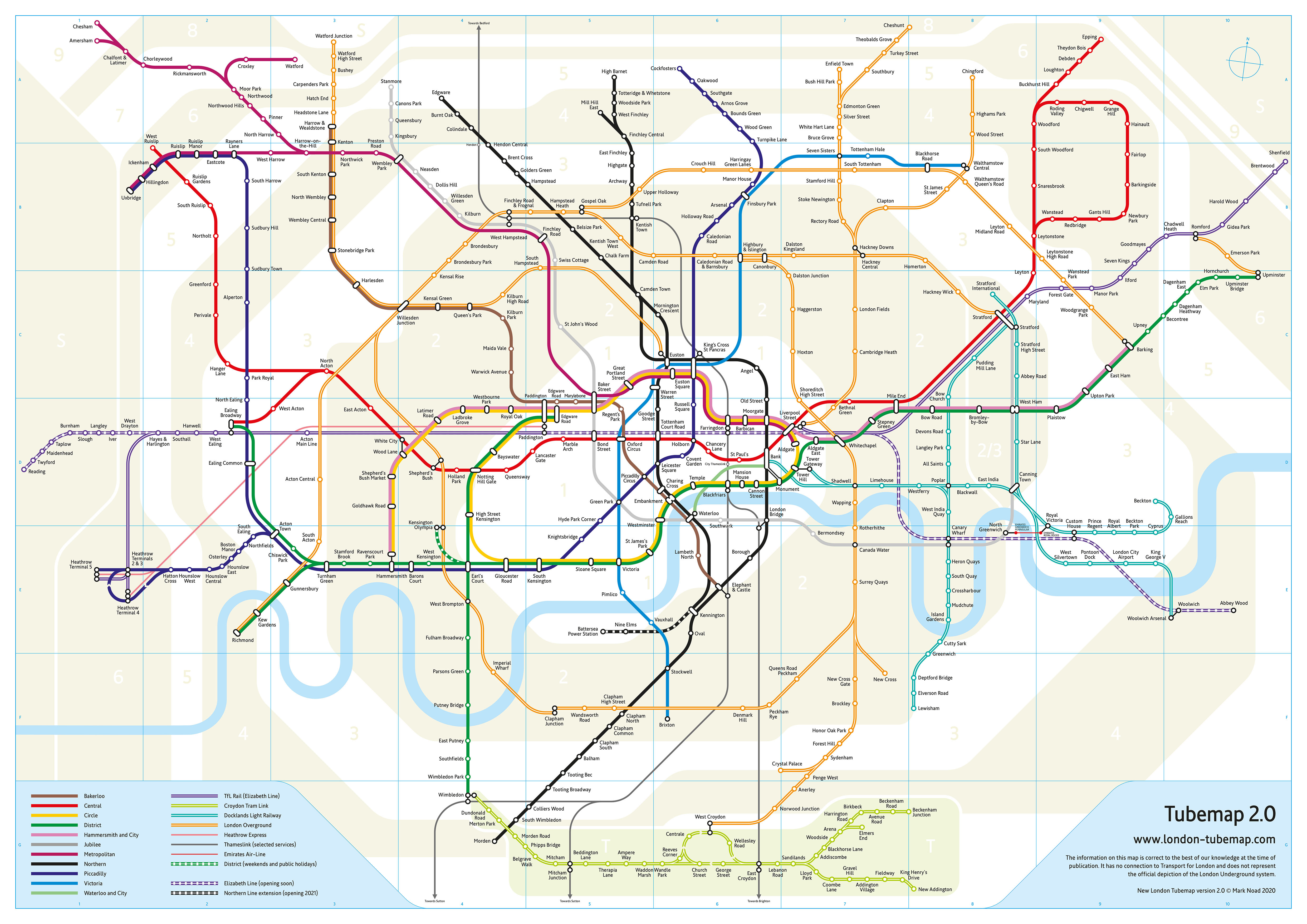
    Most recent (that I could find) Geographically accurate London Underground Map.

    Untitled Image

    If you click on the map you can zoom in.

    Oh well, give me an easy life and a peaceful death.


  • Registered Users, Registered Users 2 Posts: 27,598 ✭✭✭✭Peregrinus


    The whole point about the tube map is that it's not geographically accurate. It's a schematic, showing the connections between stations on the system rather than the geographic location of the stations. For example:

    • On the map, the distance from Earl's Court to Gloucester Road is the same as the distance from Gloucester Road to South Kensington. On the ground, the first of those distances is nearly twice the second of them.
    • On the map, High Street Kensington is further from Gloucester Road than Earl's Court is. On the ground, it's the other way around.
    • On the map, Highbury & Islington Station and Hollway Road Station are widely separated; on the ground, they are a few hundred metres apart — the journey between them is quicker by foot than it is by rail.
    • On the ground, Queensway Station and Bayswater Station are only about 150 metres apart — you can see one from the other. They're actually closer together than the two Edgeware Road stations, which the map shows as being side-by-side. (They're not.) You'd never know any of that from the map.

    Etc, etc. The insight that underpins the design of the London Underground schematic is the realisation that, by and large, users of the map don't care about the geographic location of the stations or their geographic relationship to one another, and the map doesn't need to show that accurately.

    The only geographic feature shown on the map is the River Thames, and even that is shown in a stylised and geographically inaccurate form.


  • Registered Users, Registered Users 2 Posts: 78,734 ✭✭✭✭Victor


Advertisement