Advertisement
If you have a new account but are having problems posting or verifying your account, please email us on hello@boards.ie for help. Thanks :)
Hello all! Please ensure that you are posting a new thread or question in the appropriate forum. The Feedback forum is overwhelmed with questions that are having to be moved elsewhere. If you need help to verify your account contact hello@boards.ie

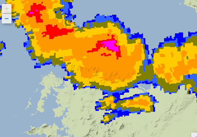
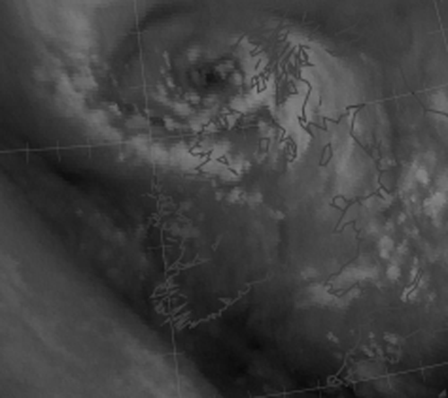
Strong gusts to 130 km/hr will redevelop Thursday after 1500h Mainly Western Counties

Options
24

Comments

  • Registered Users Posts: 14,331 ✭✭✭✭M.T. Cranium


    Have recently re-titled this thread as today's wind gusts are now generally below level one criteria but will ramp up again later Thursday especially in Connacht and Ulster, spreading to parts of west Munster and most of Leinster by evening. Gusts to 130 km/hr will be possible in more exposed coastal areas but I do expect a period of very strong gusts almost nationwide at times tomorrow evening, veering gradually from WNW to NNW. Topography will channel some of these winds so check your local exposure to northwest to assess risk in your location. The cause of this second wave of strong winds will be a polar low dropping south across Britain and while that sounds very cold, in this case the low will cause a slight increase in temperatures during the windy period, widespread snow showers early afternoon may change to more of a sleety mix with rain predominant near sea level as the strong winds develop. It is going to be very nasty over the Irish Sea and Atlantic near north Ulster and Donegal Bay. Force 11 and possibly force 12 warnings are likely around 6 p.m. to 3 a.m. overnight Thursday into Friday.

    These very strong winds should ease off by Friday morning and no further wind alerts seem likely although it will stay borderline level one until late into Saturday night in some places (mostly northerly winds Saturday).


  • Registered Users Posts: 9,717 ✭✭✭YFlyer


    I'm stuck here at the university. Wind and rain outside.

    Trying to get to the offie without getting soaked for the ole bottle of red.


  • Registered Users Posts: 9,717 ✭✭✭YFlyer


    YFlyer wrote: »
    I'm stuck here at the university. Wind and rain outside.

    Trying to get to the offie without getting soaked for the ole bottle of red.

    Update: Got to Spar with a minute to spare :)


  • Registered Users Posts: 6,879 ✭✭✭pauldry


    I cant check my exposure to wind as violent gale of 58knots has blown my weather station to pieces . A sad day :(


  • Registered Users Posts: 14,331 ✭✭✭✭M.T. Cranium


    The latest guidance tends to shift the strong winds away from east Ulster so I will amend that part, north Antrim is not likely to see damaging gusts but further west from about Donegal Bay to Dublin, these very strong west to northwest winds will develop late afternoon and evening, and will die out after midnight. Peak gusts in exposed areas could hit 120 km/hr.

    Temperatures aloft will tend to bottom out mid-day or early afternoon which may mean that snow will become more widespread for a time, then the trend will be towards more rain and less snow when it gets very windy, however, at elevations of higher roads such as the Glenshane Pass, there could be blowing snow during this event.


  • Advertisement
  • Registered Users Posts: 32,634 ✭✭✭✭Graces7


    Just had an almighty crack of sudden wind up here,, South Kerry 400 ft asl.. shook the roof ans made my ears pop


  • Registered Users Posts: 10,066 ✭✭✭✭Oscar Bravo


    Orange wind warning now issued from met eireann


  • Registered Users Posts: 32,634 ✭✭✭✭Graces7


    Orange wind warning now issued from met eireann

    They must have heard it too..


  • Closed Accounts Posts: 32,688 ✭✭✭✭ytpe2r5bxkn0c1


    Graces7 wrote: »
    They must have heard it too..

    Relax, it's for Donegal, Galway, Leitrim, Mayo, Sligo and Clare. Not Kerry.


  • Registered Users Posts: 14,331 ✭✭✭✭M.T. Cranium


    Could a moderator possibly upgrade to level two? Thanks, I was able to edit the thread title but not the level.

    Now looking very ominous for this evening in Connacht and west Ulster as a very tight circulation appears to have developed around a 970 mb low dropping south along the outer Hebrides. Buoy K5 near Rockall no longer reports wind speeds but can see a sharp pressure wave signature past three hours and satellite imagery indicates a well-developed northwesterly flow that will hit Donegal Bay around 7 or 8 p.m. with possible gusts to 130 km/hr. This very strong wind event will rapidly sweep inland and through the north central counties to the east coast. Counties from Louth to north Wicklow could see equally strong gusts where not blocked out by higher ground to northwest. It will become very stormy over the Irish Sea around 11 p.m. or midnight.

    Updates to follow, buoy M4 should be closely watched as this event will hit there about an hour before reaching the Donegal and Mayo coasts.

    Strong level 2 for all regions except possibly east Ulster and Waterford-Carlow-Kilkenny-Laois level 1. Possible localized level 3 conditions in exposed locations. If you're in the main path, assess for level 3 risk by considering topography to your northwest, is there an opening for winds to be funnelled, or are you somewhat sheltered by hills in that direction? Dublin area posters may be more familiar with local effects in a northwest gale as these are rather rare, usually strong winds for Dublin are WSW or sometimes SE.


  • Advertisement
  • Registered Users Posts: 11,134 ✭✭✭✭maquiladora


    Need to keep an eye on that little low heading for Donegal Bay.

    3hr-wind.gif?1627


  • Registered Users Posts: 10,066 ✭✭✭✭Oscar Bravo


    1800 reports....gust of 62 knots at Finner, 53 at Newport(mayo)


  • Registered Users Posts: 1,597 ✭✭✭corsav6


    1800 reports....gust of 62 knots at Finner, 53 at Newport(mayo)

    Some strong gusts here outside Newport, Mayo. Would probably just hit a level 2 at the moment but nothing to worry about just yet.


  • Registered Users Posts: 12,778 ✭✭✭✭ninebeanrows


    It has the hallmarks of a polar low. These type of features are vicious.

    Would expect things to turn pretty hairy in the northwest soon.


  • Registered Users Posts: 11,505 ✭✭✭✭Xenji


    corsav6 wrote: »
    Some strong gusts here outside Newport, Mayo. Would probably just hit a level 2 at the moment but nothing to worry about just yet.

    Really picked up out the Newport Road within the space of an hour or so.


  • Registered Users Posts: 9,010 ✭✭✭Tom Cruises Left Nut


    Some sparks coming out of it off the north coast


  • Registered Users Posts: 1,981 ✭✭✭squarecircles


    Severe squally gusts in louisburgh Co. Mayo have started.


  • Registered Users Posts: 10,066 ✭✭✭✭Oscar Bravo


    Turning extremely windy here in Westport now


  • Registered Users Posts: 6,235 ✭✭✭Oneiric 3


    Getting pretty gusty now

    New Moon


  • Registered Users Posts: 14,331 ✭✭✭✭M.T. Cranium


    The polar low feature is around 967 mbs and is located about 50 miles NNE of Malin Head and just to the west of Tiree. Winds are very light in the Hebrides as all the energy of this low is on its western flank. The track will be roughly mid-Derry south-southeast to emerge into Irish Sea near Dundalk. Expect some very strong gusts across Donegal, Mayo, Sligo, Leitrim, Roscommon, Galway, north Clare, Derry, Fermanagh and Tyrone this evening, shifting rapidly to Cavan, Monaghan, Louth, Westmeath, Longford, Offaly, Meath, Dublin, Kildare by about 11 pm. There is a very strong gradient shown on meso-scale models (one that I just consulted has the track a bit too far east at first, so have adjusted its guidance to actual 18z position).

    Some models have failed to pick up this feature (GFS for example shows no separate centre) and so would advise that you go old school and follow the radar, obs and reports as this quickly moves through overnight.

    Anyone reading this in Antrim, Down or Armagh be aware that there will be a very sharp cutoff of strong winds (to west of track) and you might catch some strong gusts if located in western portions of those counties while in east, winds will tend to swirl around at rather low speeds until several hours after the low passes, then pick up gradually to 80 km/hr from north.

    Max winds will be associated with squally showers and some thunder is possible. Temperatures are going to rise rather than fall so snow line will retreat upslope to about 300m for a time then start coming back down the mountain so to speak.


  • Advertisement
  • Closed Accounts Posts: 922 ✭✭✭FWVT


    It certainly does look like a polar low, both on sat and on models. The 0.05 km WRF shows a distinct warm core.

    336926.png

    336927.jpg


  • Registered Users Posts: 6,235 ✭✭✭Oneiric 3


    Pretty intense looking cell moving into the N Mayo coast, could help trigger some lightning there. Already a number of strikes over Donegal/Leitrim area.

    7YnmJZ.png

    New Moon


  • Moderators, Science, Health & Environment Moderators Posts: 11,822 Mod ✭✭✭✭Meteorite58


    Out of the main firing line but strong winds nonetheless, 10 min avg 34.8 kph, recent gust 57 kph here on the North Kerry coast

    Temp rising 6.3C atm

    Bar 989.5mb Steady


  • Registered Users Posts: 981 ✭✭✭mountainy man


    Some impressive lightning and hail here at the mo.


  • Closed Accounts Posts: 922 ✭✭✭FWVT


    Pretty windy at Donegal Airport now.

    SPECI EIDL 291947Z AUTO 31041G53KT 5000 FEW012 BKN038 OVC047 07/02 Q0976=


  • Registered Users Posts: 6,235 ✭✭✭Oneiric 3


    FWVT wrote: »
    It certainly does look like a polar low, both on sat and on models. The 0.05 km WRF shows a distinct warm core.

    The center also has a small dry core, not sure what this means - if it is to mean anything at all.

    4V4mgt.png

    New Moon


  • Registered Users Posts: 74 ✭✭Dollseyes


    Thunder and Lightning in Ballina. Mayo.


  • Registered Users Posts: 5,565 ✭✭✭Pangea


    Loads of ligthning here too.


  • Registered Users Posts: 10,066 ✭✭✭✭Oscar Bravo


    Lightning in Castlebar now


  • Advertisement
  • Registered Users Posts: 186 ✭✭shmaupel


    Gusting over 90kmph atm with absolutely fabulous sheet lightening!

    South Donegal.


Advertisement