Advertisement
If you have a new account but are having problems posting or verifying your account, please email us on hello@boards.ie for help. Thanks :)
Hello all! Please ensure that you are posting a new thread or question in the appropriate forum. The Feedback forum is overwhelmed with questions that are having to be moved elsewhere. If you need help to verify your account contact hello@boards.ie

WWII structures in Donegal

Options
135

Comments

  • Registered Users Posts: 520 ✭✭✭piston


    muckish wrote: »
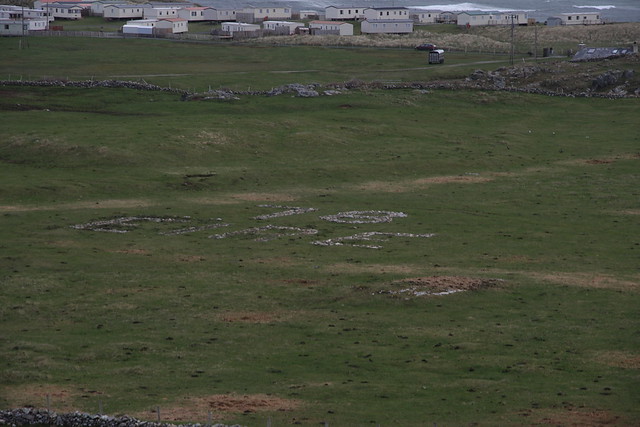
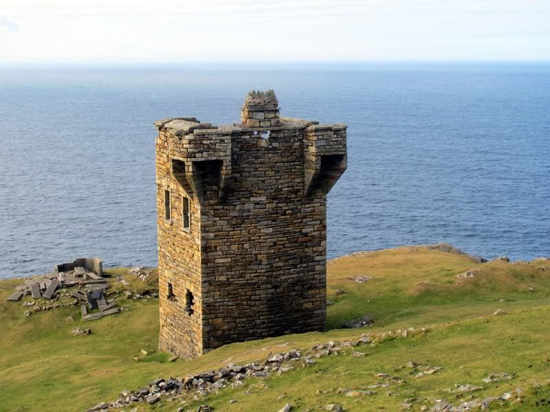
    Whoever cleared this, well done. Another piece of our Heritage uncovered. Melmore Head.
    7043088151_55df1f676a_z.jpg

    I visited this on Friday. I never even knew it existed until I saw this thread and I've been in that area many times.

    Couldn't get a decent photo as I only had a small digital camera with me.


  • Registered Users Posts: 9 Mike in CT


    Jim S wrote: »
    There is a PBY crash site near Kinnlough just outside Bundoran , crashed there in March 41 , the first operational use of the PBY by the RAF flew over the night before from Stranraer to Castle Archdale .
    The crew from the aircraft are all ( apart from one member) buried in Irvinestown County Fermanagh in the C of I graveyard.

    There are three other PYB crashes which spring to mind one near Lough Alaban near the viewpoint at Lough Navar another near Whitehill Ballinamallard and another near Ely Lodge all in County Fermanagh.
    No wreckage on site .

    The crashes in Fermanagh all came from 131 OTU at Killadeas, another crashed at Duross Point ( near Castle Archdale) it undershot the landing area,also on the Lough itself three others which spring to mind one in May 1941 which as not recovered it crashed in May 41 , landing on a flat calm Lough a mirror surface the pilot misjudged his approach and the aircraft crashed, there is a memorial to the crew on the break water entrance to the moorings at CA.
    The others, January 44 near Dreenan shore Boa island , practise bombing on a moored target South of Boa Island, it failed to recover from a dive and crashed, the other crashed on the flarepath at CA in May 43.

    I can give you more details on these if you want.
    js


    Thanks for all the information Jim. Do you know if any wreckage exisits at any of the sites that would include the engines.?

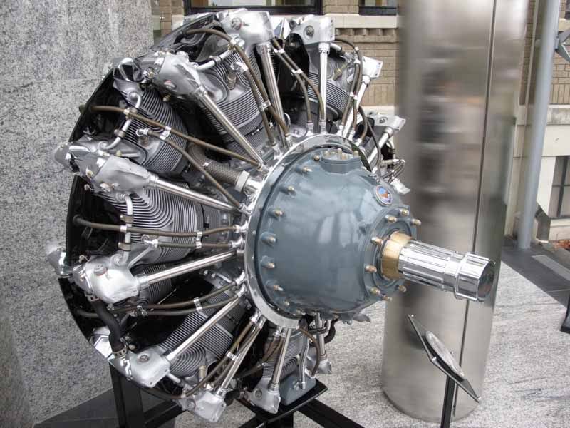
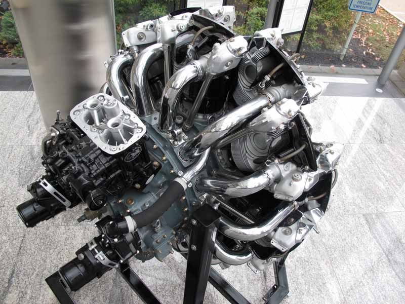
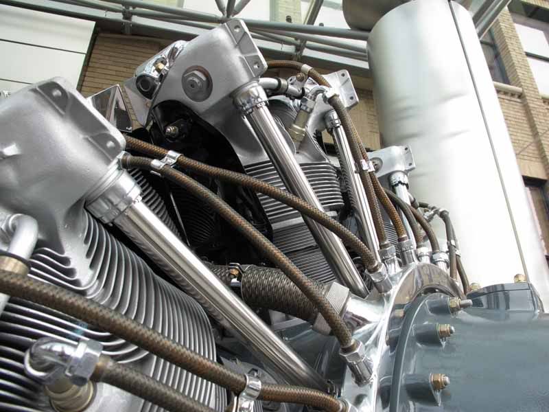
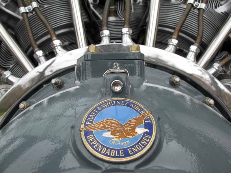
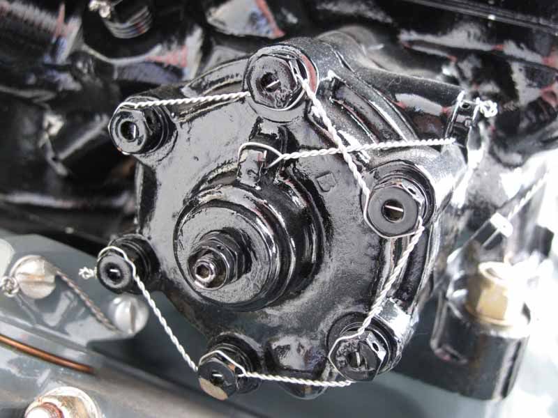
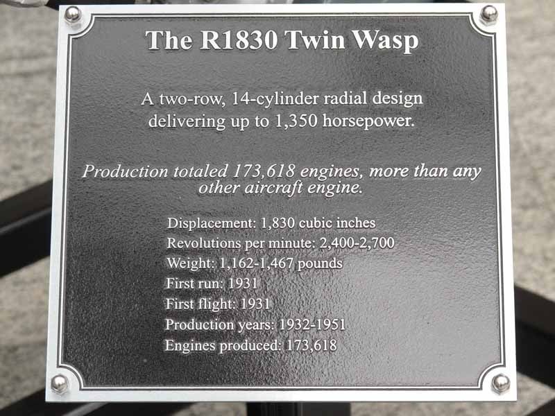
    The type of engine used on the PBY was a Pratt & Whitney R1830. A fully restored R1830 is on display at the main entrance of the facility where I work. I took a few photos.

    TwinWasp10-1.jpg

    TwinWasp11-1.jpg

    TwinWasp9-1.jpg

    TwinWasp12-1.jpg

    TwinWasp1-1.jpg

    TwinWasp14-1.jpg

    This particuar engine was made by Chevrolet, when they switched over from automobile manufacturing to support the war effort.


  • Registered Users Posts: 610 ✭✭✭muckish


    Mike in CT wrote: »
    Thanks for all the information Jim. Do you know if any wreckage exisits at any of the sites that would include the engines.?

    The type of engine used on the PBY was a Pratt & Whitney R1830. A fully restored R1830 is on display at the main entrance of the facility where I work. I took a few photos.

    TwinWasp12-1.jpg


    This particuar engine was made by Chevrolet, when they switched over from automobile manufacturing to support the war effort.

    What a beautiful piece of machinery.


  • Registered Users Posts: 131 ✭✭Jim S


    Mike, unfortunately no engine parts on any of these locations. :(


  • Registered Users Posts: 9 Mike in CT


    Thanks for looking into this Jim.

    The air cooled radial engines had the advantage that they could take more battle damage by not depending on a liquid cooling system, but had a large frontal that hurt aerodynamics. This is also the engine that powered a C47 Sky Train across the English Channel in 1944 towing a Waco glider that my father was in on his way to Holland being a nineteen year old serving with the 82nd Airborne Division, 325th Glider Infantry Regiment. I think back and imagine that his parents Thomas Maloney and Annie O'Gara of Meenaveen had some sleepless nights during those times.

    Mike


  • Advertisement
  • Registered Users Posts: 610 ✭✭✭muckish


    This 3 part programme starting on BBC tonight.
    http://www.bbc.co.uk/programmes/b01hzqzj


  • Registered Users Posts: 131 ✭✭Jim S


    WW2 dig , yes looking forward to it.(I helped one of the researchers in a minor way putting him in touch with one or two folks).
    360 are a very good company so the end product should be worth seeing. :).


  • Registered Users Posts: 31 GERRYMAC65


    There is a concrete bunker type shed 3/4 covered in sand on Rosnowlagh beach,just up from the sands hotel.I remember it well as a child,it gets more covered each year,it would be a pity to lose it.


  • Registered Users Posts: 1,842 ✭✭✭Rob A. Bank


    Read the thread with great interest...

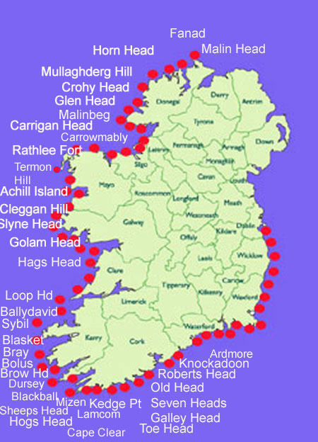
    I notice that they have restored the EIRE sign on Loop head in County Clare with the help of an archeologist. http://www.clareherald.com/features/gallery/3766-loop-heads-ww2-eire-sign-is-restored.html Pity the same is not done with more of them, it is after all an important part of our history.

    I came across this great site by an Austrian photographer http://www.lookoutpost.com/geo/lop1/ who photographed all the lookout posts and the panoramas they looked out on. Its a great pity to see that only 51 of the original 82 are now standing and that most of the EIRE signs are gone.

    A walking/cycling route from the first one to the last one would be a fabulous tourist draw, situated as they are with all the best sea views in Ireland.

    :)


  • Registered Users Posts: 8,219 ✭✭✭Calina


    I'm actually in the middle of putting a google map together of the ones which can actually be seen - mainly because I couldn't find one existing during the week.

    I have located on a map:

    1) Malin
    2) St John's Head
    3) Black Head in Clare
    4) Erris Head,
    5) Dursey Island
    6) I know roughly where the Loop Head one is but the sat image is too old and predates its being unearthed.

    I also know roughly where there is one on Inishowen and based on the contents of this thread believe I know roughly where the Melmore Head one should be located.

    I'm hampered by the lack of resolution on the google map for various parts of ireland.

    I've been told there was one in Bray Head, Valentia, visible 20 years ago. I've failed to find it.

    I'm hoping to track down all of the still visible EIRE markings - the Schmelzer project on the look out posts caters for the lookout shelters but it's the signs which fascinate me most.

    I'd value any more information on them. Based on this thread, I may switch the map search to the OSI site anyway initially as the resolution seems to be better.

    Thanks you all.


  • Advertisement
  • Registered Users Posts: 14,023 ✭✭✭✭retalivity


    try the osi site...thats got a better resolution map of the whole of ireland

    http://maps.osi.ie


  • Closed Accounts Posts: 1,281 ✭✭✭donegal_road


    Calina wrote: »
    I'm actually in the middle of putting a google map together of the ones which can actually be seen - mainly because I couldn't find one existing during the week.

    I have located on a map:

    1) Malin
    2) St John's Head
    3) Black Head in Clare
    4) Erris Head,
    5) Dursey Island
    6) I know roughly where the Loop Head one is but the sat image is too old and predates its being unearthed.

    I also know roughly where there is one on Inishowen and based on the contents of this thread believe I know roughly where the Melmore Head one should be located.

    I'm hampered by the lack of resolution on the google map for various parts of ireland.

    I've been told there was one in Bray Head, Valentia, visible 20 years ago. I've failed to find it.

    I'm hoping to track down all of the still visible EIRE markings - the Schmelzer project on the look out posts caters for the lookout shelters but it's the signs which fascinate me most.

    I'd value any more information on them. Based on this thread, I may switch the map search to the OSI site anyway initially as the resolution seems to be better.

    Thanks you all.

    there is one at Horn Head, Dunfanaghy. If I think of any more I'll post them


  • Registered Users Posts: 8,219 ✭✭✭Calina


    Thanks. I can pick up the look out post okay on the map but I'm having trouble finding the Eire sign - am I just being blind or is there so little of it left it can't be discerned. ETA: correction, I've found it. Thanks a million.

    Interestingly, I've found that the resolution coverage of Ireland is better on Bing for certain areas (Loop Head excluded) than google so I have 9 of them definitely plotted here: http://t.co/uhItXRnb - apologies for the shortened link. If you switch on aerial view, you should be able to see the signs I've found so far.

    I believe I've located the remnants of one on Valentia Island but am not fully certain. And I think there is some evidence of one on Howth as well.

    On reflection, I may drop a post about this into the history forum as well. It seems to me though as though Donegal has a few more left in existence than other parts of the country.


  • Registered Users Posts: 2,040 ✭✭✭yuloni


    This post has been deleted.


  • Registered Users Posts: 8,219 ✭✭✭Calina


    Hi.

    My primary plan is to plot the still existing ones. I'm noting the ones which have disappeared.

    I really appreciate this - I realise now I was looking in that wrong place for the second of the 71 signs. I did look in the right place for the vanished one (but since it was gone...).

    Thanks a million for this.


  • Registered Users Posts: 1,979 ✭✭✭Firblog


    Not strictly related to this thread, but may be of some interest to the people who are contributing...

    http://www.rte.ie/news/2012/1115/shipwrecks-off-coast-of-ireland.html


  • Banned (with Prison Access) Posts: 25,234 ✭✭✭✭Sponge Bob


    Mike in CT wrote: »

    IMG_1731.jpg

    That is a Napoleonic era signal tower of which there were 10 built in Donegal.

    story > http://homepage.eircom.net/~signaltowers/

    Some , eg Malin , were later taken over by Lloyds of London for ship spotting and reporting, c 1870.

    towermap.jpg


    http://homepage.eircom.net/~signaltowers/index.html

    and

    http://photopol.com/dca4/archirl_towers.pdf

    The Napoleonic era towers were manned by a group called the "Sea Fencibles" http://en.wikipedia.org/wiki/Sea_Fencibles

    They were in four groups in Donegal . Malin to Horn ( misspelt Hoon) and Horn to 'Teeling Head' as Bunaglas was called.

    Malin - Horn
    Horn Teeling
    Teeling - Donegal
    Ballyshannon - Killala

    I think the coast from Donegal to Ballyshannon was deemed 'loyal' :)

    http://www.pbenyon.plus.com/Navy_List_1805/Officers/Sea_Fencibles.html
    http://www.nationalarchives.gov.uk/Catalogue/DisplayCatalogueDetails.asp?CATID=131&CATLN=3&FullDetails=True&j=1


  • Registered Users Posts: 447 ✭✭Connacht


    Malin Napoleonic Tower, in Sponge Bob's pic, is in outstanding condition. Notice the ruined WW II LOP in front of it.
    Re the EIRE signs, is it known how many LOPs would have had more than one sign associated with them, as is the case on Achill ?
    Re pic of 03.04.12 from Muckish of Melmore Head, unfortunately those who uncovered it forgot to do the perimeter stones which would also have made up an integral part of the sign.


  • Registered Users Posts: 8,219 ✭✭✭Calina


    I am being given mixed signals about Achill. I have been told the second Achill sign was in Currane, which is not actually on the island but is Achill postal area. It is linked to a different look out post, namely Corraun.

    I'm aware that a second one was built in the Slieve League area but that one of those signs has vanished completely.

    In fact, a lot of locations had two signs built - the second being built because the first was too small to be seen clearly from the air, but for the purposes of counting, where a second was built because of size rather than two large ones being built for the same look out post, I am not counting them as doubles. There's a very clear photograph of the site in Cahore in Wexford (prior to its removal) demonstrating this. I have seen some comments to the effect that two were built on Malin Head but have only found one so far and am wondering if the second mentioned is the site at Inishowen Head which is on the same peninsula. I am hoping that the logbooks of the Look Out Posts will have some more information as I understand the signs were built in 1942 and 1943.

    The frame does not appear to be on all remaining signs and I have some doubts in fact that they were built at all sites.

    Of the 84 which I am reasonably sure were built, I'm aware of 20 still in existence and can locate 19 of them on satellite imagery. The exception is Loop Head in Clare which a) is too recent to appear on the Google maps imagery available at the moment and b) is located in a zone which has absolutely no coverage on the Bing maps imagery. It was too recently renovated to appear on the OSI images available at the moment as well.

    From what I can see, none of the signs on the east coast have survived and most of the ones on the south coast are gone too.

    I have not been able to locate any in Galway so far. I understand the sign in Mullaghmore in Sligo to be completely overgrown and no longer visible.

    There are screencaps of what I have found here.

    www.eiremarkings.org.

    The site is very much a work in progress at the moment and I will be adding more to it as and when I get it and have time. I sort of need a break from scanning fields from mapping imagery as I have done an awful lot of it lately.

    Thanks for the help by the way. If anyone knows where the one on Slyne Head was, that would help a lot. I cannot believe all the signs in Galway are gone.


  • Registered Users Posts: 447 ✭✭Connacht


    Hi Calina,
    Here's the situation in Mayo :
    LOP57 - Roonagh - hut still standing, sign prob buried under fern & heather.
    LOP58 - Corraun - hut still standing, you have a pic of sign.
    LOP59 - Achill - hut still standing, 2 signs, you have a pic of one, the other is on the north side of the island almost totally buried in heather.
    LOP60 - Termon Hill - hut half-collapsed but just about standing, you have a pic of the sign at Glosh.
    LOP61 - Annagh Head - hut collapsed, sign still visible though sinking into ground.
    LOP62 - Erris Head - hut still standing, you have a pic of sign.
    LOP63 - Portacloy - hut still standing, you have a pic of sign.
    LOP64 - Downpatrick Head - hut still standing, don't know about sign.
    LOP65 - Kilcummin Head - hut still standing, don't know about sign.
    I have searched unsuccessfully for the Roonagh sign, but have visited all the 7 mentioned here. I doubt if Kilcummin or Downpatrick signs still exist, as both these headlands are decent grassland right to the cliff edge, so they're likely to have been removed by landowners.


  • Advertisement
  • Banned (with Prison Access) Posts: 25,234 ✭✭✭✭Sponge Bob


    After WW2 ( c 1946-1952) a load of aerial photos were taken by the Irish Air Corps in conjunction with the British (....the better to help the US re invade Europe ) These photos are called Operation Sandstone and would show most of the Eire signs.

    Here are ALL the LOPs numbered, photographed and Geocoded. The Eire signs were co located with them.

    http://www.lookoutpost.com/geo/lop1/

    About the aerial photos. See

    http://www.nationalarchives.gov.uk/catalogue/displaycataloguedetails.asp?CATLN=3&CATID=429&SearchInit=4&SearchType=6&CATREF=ADM+326
    1945-1992
    Arrangement
    The files are arranged geographically, covering the west coast of Scotland and outlying islands, then from north to south, the east coast of Scotland and the remainder of the British Isles in a clockwise direction; Northern Ireland, Eire and Jersey are also covered.

    and

    http://discovery.nationalarchives.gov.uk/SearchUI/browse/C6059397?v=h
    http://discovery.nationalarchives.gov.uk/SearchUI/details?Uri=C6059397

    You would fly into Heathrow :)

    I don't know where the Irish records are held but the Military History Society would know who researched Sandstone to date and where 'our' photos are held.

    see

    http://www.mii.connect.ie/books/The%20Irish%20Air%20Corps.html

    http://www.mhsi.ie/contactus.htm

    and a reference

    http://www.mhsi.ie/Table_of_Contents_%20VolXXVI.pdf
    Operation Sandstone –– a story of British and Irish post-war
    co-operation Guy Warner

    This guy I think.


    http://www.amazon.co.uk/Guy-Warner/e/B001K7PN0O/ref=ntt_athr_dp_pel_1


    These are his publishers. :)

    http://www.colourpointbooks.co.uk/

    Eire sign on Toe Head in Cork

    http://binged.it/Zm2yer

    Dursey Island in Cork ( left)

    http://binged.it/UJu9iu


    HTH


  • Registered Users Posts: 8,219 ✭✭✭Calina


    Connacht wrote: »
    Hi Calina,
    Here's the situation in Mayo :
    LOP57 - Roonagh - hut still standing, sign prob buried under fern & heather.
    LOP58 - Corraun - hut still standing, you have a pic of sign.
    LOP59 - Achill - hut still standing, 2 signs, you have a pic of one, the other is on the north side of the island almost totally buried in heather.
    LOP60 - Termon Hill - hut half-collapsed but just about standing, you have a pic of the sign at Glosh.
    LOP61 - Annagh Head - hut collapsed, sign still visible though sinking into ground.
    LOP62 - Erris Head - hut still standing, you have a pic of sign.
    LOP63 - Portacloy - hut still standing, you have a pic of sign.
    LOP64 - Downpatrick Head - hut still standing, don't know about sign.
    LOP65 - Kilcummin Head - hut still standing, don't know about sign.
    I have searched unsuccessfully for the Roonagh sign, but have visited all the 7 mentioned here. I doubt if Kilcummin or Downpatrick signs still exist, as both these headlands are decent grassland right to the cliff edge, so they're likely to have been removed by landowners.

    Hi Connaught.

    I've scanned the area around Annagh Head several times now and I'm still not seeing evidence of the sign. I know you said it was sinking into the ground but I've tracked down a couple that are almost invisible on the area photographs so I'd like to find this if possible. I'll have another look for Roonagh but I suspect you're right about Kilcummin and Downpatrick.

    Thanks a million for the feedback. I appreciate it.


  • Registered Users Posts: 8,219 ✭✭✭Calina


    Sponge Bob wrote: »
    After WW2 ( c 1946-1952) a load of aerial photos were taken by the Irish Air Corps in conjunction with the British (....the better to help the US re invade Europe ) These photos are called Operation Sandstone and would show most of the Eire signs.

    Here are ALL the LOPs numbered, photographed and Geocoded. The Eire signs were co located with them.

    http://www.lookoutpost.com/geo/lop1/

    I've found this site extremely helpful thanks to the photographs of the LOPs which have helped me to track stuff down on the maps.
    Sponge Bob wrote: »
    About the aerial photos. See

    http://www.nationalarchives.gov.uk/catalogue/displaycataloguedetails.asp?CATLN=3&CATID=429&SearchInit=4&SearchType=6&CATREF=ADM+326


    and

    http://discovery.nationalarchives.gov.uk/SearchUI/browse/C6059397?v=h
    http://discovery.nationalarchives.gov.uk/SearchUI/details?Uri=C6059397

    You would fly into Heathrow :)

    I don't know where the Irish records are held but the Military History Society would know who researched Sandstone to date and where 'our' photos are held.

    Thanks for this. I'm aware that the Aer Corp did aerial photographs post war and I am hoping that the Irish Military Archives can help with this. They have the remaining LOP log books and they reopen again on Monday so I will look for an appointment for the following week (next week is not an option for me) to have a look at the books from late 1942 to 1943 when I believe the signs were built.
    Sponge Bob wrote: »

    Thanks a million for all this. I seem to have opened a Pandora's box with this as it's fascinated me more and more as I've tracked down more information about them.
    Sponge Bob wrote: »

    This guy I think.


    http://www.amazon.co.uk/Guy-Warner/e/B001K7PN0O/ref=ntt_athr_dp_pel_1


    These are his publishers. :)

    http://www.colourpointbooks.co.uk/

    Eire sign on Toe Head in Cork

    http://binged.it/Zm2yer

    Dursey Island in Cork ( left)

    http://binged.it/UJu9iu


    HTH


    I have the signs in Cork, or what's left of them anyway. The one in Baltimore was restored sometime recently as it's quite clearly identifiable.

    Trying very hard to find one, at least, in Galway as it's the only western seaboard county where I haven't found the remains of one.

    ________________________

    want to thank all of you for your help - it means a lot to me.


  • Closed Accounts Posts: 1,281 ✭✭✭donegal_road


    thought this might be of interest to you. Its a Sherman tank on the sea bed off Malin Head


  • Closed Accounts Posts: 5,852 ✭✭✭homer simpson


    thought this might be of interest to you. Its a Sherman tank on the sea bed off Malin Head

    I have to say that's pretty damned cool! :cool:


  • Closed Accounts Posts: 1,281 ✭✭✭donegal_road


    I have to say that's pretty damned cool! :cool:

    you'd have difficulty starting her because the engine is flooded!


  • Closed Accounts Posts: 5,852 ✭✭✭homer simpson


    you'd have difficulty starting her because the engine is flooded!

    I believe in my trusty can of WD40! :D


  • Closed Accounts Posts: 1,281 ✭✭✭donegal_road


    not exactly a WW2 structure, but thought Id post it anyway. It is a photo taken on the Diamond in Donegal before the monument was built.
    11th Battalion around Spring 1915 on way to trenches in France , Lord Leitrim on the right on horse.


  • Registered Users Posts: 692 ✭✭✭Durnish


    Yippee, I can't believe it but I think I have found the Crohy Head Eire sign stones, using the old 1995 OSI map aerial view.

    Is it a breach of copyright to paste a screen grab of the OSI page?


  • Advertisement
  • Registered Users Posts: 610 ✭✭✭muckish


    Durnish wrote: »
    Yippee, I can't believe it but I think I have found the Crohy Head Eire sign stones, using the old 1995 OSI map aerial view.

    Is it a breach of copyright to paste a screen grab of the OSI page?

    Just copy and paste the URL from the osi Mapviewer when you have it centered on the point. That'll link to your location. Dying to see this as I've struggled with this one!


Advertisement