Advertisement
If you have a new account but are having problems posting or verifying your account, please email us on [email protected] for help. Thanks :)
Hello all! Please ensure that you are posting a new thread or question in the appropriate forum. The Feedback forum is overwhelmed with questions that are having to be moved elsewhere. If you need help to verify your account contact [email protected]

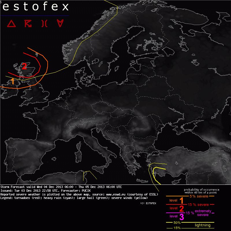
Severe Winds Likely Thursday 5th Dec Morning (Northern areas most at risk)

  • 03-12-2013 8:53pm
    #1
    Registered Users Posts: 12,778 ✭✭✭✭


    I think a thread for this is essential, a rapidly developing low pressure system will race from southeast of Greenland to be positioned just east of Aberdeen by Thursday midday having bombed over 35hPa in 24 hours.

    To the south of the low will be a very tight pressure gradient with an intense jet-streak aloft.

    Winds just above the surface will be incredibly fierce.

    Scotland and northern parts of England will be the major focus for the most severe winds but parts of the northern half of Ireland will be in the red zone also.

    Just ahead of the cold front passage a tightening of the gradient will lead to a particularly intensive few hours of wind over parts of Ireland, with wind gusts peaking around 9am Thursday morning.

    Widespread gusts over Ulster will reach 110-130 km/hr. While i would expect gusts from 100-115 km/hr into northern Leinster including Dublin.

    Some wind estimates.
    Malin Head could get pretty hard hit, would anticipate seeing a gust between 75-80 knots during Thursday morning.

    Dublin Airport: 60/ 65 knot peak gust.

    850hPa winds @ 36hrs

    Rtavn3612.png

    925hPa winds @ 36hrs

    Rtavn3613.png


«134

Comments

  • Registered Users Posts: 12,778 ✭✭✭✭ninebeanrows


    Bear a thought for those in the Low Countries as this vicious storm tracks down the North Sea.

    gfs-0-45-3h.png?18


  • Registered Users Posts: 12,778 ✭✭✭✭ninebeanrows


    Estofex have issued a warning.

    2013120506_201312032258_2_stormforecast.xml.png

    DISCUSSION

    ... Northern Ireland, Scotland ...

    In the exit region of a cyclonically curved jet-stream, reaching over 80 m/s at 300 hPa level, rapid cyclogenesis is forecast over the Atlantic and the center of the low is forecast to be centered just north of Scotland by Thursday 06 UTC. Intense pressure / geopotential gradient will support windspeeds of 40 to 50 m/s in 925 to 850 hPa level. Both GFS and ECMWF simulate marginal CAPE values just behind the main stratiform rain shield, suggesting split-front character. CAPE should be connected to a tongue of moister airmass just ahead of the surface cold front, so that strong forcing might support a compact, linearly oriented, low-topped convective system. With intense vertical wind field, such system could contribute to the "downward mixing" of momentum and extremely severe wind gusts will be well possible, especially over Scotland around 06 UTC. Tornadoes should be possible too given extreme low level wind shear and low cloud bases, but will likely be limited by the lack of isolated supercell mode. For the region with the highest threat, Level 2 seems to be warranted.


  • Registered Users Posts: 12,778 ✭✭✭✭ninebeanrows


    Met Eireann have issued Orange Warning.
    National Weather Warnings

    STATUS ORANGE

    Wind Warning for Connacht, Cavan, Monaghan and Donegal
    West to southwest winds will reach mean speeds of 55 to 70kph and gusts of 100 to 120kph tonight

    Issued:Wednesday 04 December 2013 09:00
    Valid:Thursday 05 December 2013 00:01 to Thursday 05 December 2013 12:00


    STATUS YELLOW

    Wind Warning for Munster and Leinster
    West to southwest winds will reach mean speeds of 45 to 65 kph and gust 80 to 110kph.

    Issued:Wednesday 04 December 2013 09:00
    Valid:Thursday 05 December 2013 00:01 to Thursday 05 December 2013 12:00


  • Registered Users Posts: 5,068 ✭✭✭Iancar29


    I'll go for max gust at malin to be 125kmh :)


  • Registered Users Posts: 12,778 ✭✭✭✭ninebeanrows


    Iancar29 wrote: »
    I'll go for max gust at malin to be 125kmh :)

    Malin Head: 138 km/hr for me :D


  • Advertisement
  • Registered Users Posts: 295 ✭✭Winger_PL


    It seems like this one might even reach me down here in Cracow. Severe weather warnings have been issued this morning for heavy snow storms and savage winds for pretty much all of Poland.


  • Registered Users Posts: 12,778 ✭✭✭✭ninebeanrows


    Malin Head: 138 km/hr for me :D

    This is based on the chance of 925hPa winds getting close to the surface.

    A pretty nasty chart with a swathe of 75knot+ over the far north of Ireland.

    Rtavn2413.png


  • Registered Users Posts: 845 ✭✭✭tylercollins


    I'm debating with myself here on heading to Malin Head around 3/4am tomorrow morning.. Trying to get someone else to go with me though! First proper storm of the winter and looks to be a good'un around the coast!

    I see metoffice now have yellow warning for most of NI with amber warning for east coast, but from that chart above, they should have amber warning for most of northern ireland! Wind gust of 80mph is bound to cause disruption around rush hour in the morning!!


  • Registered Users Posts: 5,068 ✭✭✭Iancar29


    This is based on the chance of 925hPa winds getting close to the surface.

    A pretty nasty chart with a swathe of 75knot+ over the far north of Ireland.

    Rtavn2413.png

    But convection would be needed to bring them down to the surface no? .... and cant see much of that happening.


    @Winger_pl ... Hate you pal !!! haha
    Hope you have a timelapse or some videos planned for us here! :)


    @tylercollins ... If there was more of a snow risk still for the north i wouldve tried to of gone up for a the DOUBLE event ...
    Not much your gonna get in the pitch black though , as long exposures will no doubt look shakey ! ha
    Stay safe though if ya do go out!


  • Registered Users Posts: 845 ✭✭✭tylercollins


    I'm going more for the experience ;) Down around the harbour in Malin Head, waves crashing over the wall, then up at the radio tower on the peak of the Island.

    That spare room is always available for you :P


  • Advertisement
  • Registered Users Posts: 12,778 ✭✭✭✭ninebeanrows


    Hey IanCar, i think the Estofex forecast alludes to the prospect of some instability ahead of the CF. I would not expect wide spread gusts of 75 knots across NI! But i would expect the odd gust to this level in that region. Especially the exposed Malin Head station.


  • Registered Users Posts: 11,134 ✭✭✭✭maquiladora


    Should be an interesting one to follow in the North Sea.
    A major storm in the North Atlantic is expected to bring a blast of cold weather to northwestern Europe in the coming days. Despite extremely heavy rain, snow and winds of 130kph, the main concern will be a major storm surge which is expected to coincide with a period of spring high tides.

    As the storm develops late on Wednesday and through Thursday, much of Scotland, the Netherlands, northern Germany, Denmark and southern Scandinavia will be buffeted by severe gale force winds.

    Strengthening winds through Wednesday will be accompanied by snow which will sweep across Scotland and southern Norway on Thursday afternoon. During the evening and night, snow will impact upon the North Sea coasts of the Netherlands, Germany and Denmark. Blizzard-like conditions will prevail for a time before the snow turns more showery in nature overnight.

    The weather is likely to disrupt transport across the region, with airports such as Glasgow, Amsterdam’s Schipol, Hamburg and Copenhagen experiencing delays and cancellations. Most ferries are likely to be delayed or cancelled during Thursday and Friday.

    Of greatest concern is the likelihood of a major storm surge, a dome of water produced by a combination of low pressure and, more importantly, severe gale to storm force winds.

    Coastal defences are likely to be tested to the limit as a storm surge estimated to be at least 3 metres high coincides with a period of spring high tides. In anticipation of the surge, the Dutch port of Rotterdam’s flood gates are expected to be closed for the first time since they were built in the 1990s.

    The region is well used to devastating storm surges, the greatest of which occurred on the night of January 31 1953. A severe storm brought a surge of 5.6 metres. Sea defences in eastern England, the Netherlands and Belgium were overwhelmed. 2,551 people lost their lives, more than 1,800 of those in The Netherlands alone. Another 230 people lost their lives in shipwrecks and other maritime incidents.

    There is no suggestion that Thursday and Friday’s surge will be in any way comparable with 1953, but this is likely to be the severest test of defences across the North Sea region in the last 20 years.

    http://www.aljazeera.com/weather/2013/12/storm-surge-risk-north-sea-nations-20131249394125491.html

    Red warning for Northern Germany:

    http://www.meteoalarm.eu/en_UK/1/0/DE012-Schleswig-Holstein.html

    Wolken__Spitzenboeen__XAVER,templateId=poster,property=poster.jpg


  • Registered Users Posts: 12,778 ✭✭✭✭ninebeanrows


    Not much chatter on this.

    It is going to be a very windy rush-hour tomorrow morning across much of the country. High winds hitting at in-opportune time.

    Dublin region still at risk of gusts from 100-110km/hr tomorrow morning, and this will be noticed.

    Parts of Ulster should prepare for gusts to 130km/hr.

    The system will pass through rapidly so winds will abate tomorrow afternoon.


  • Registered Users Posts: 845 ✭✭✭tylercollins


    Would I be right in saying that winds will being picking up between 3am & 6am in the North West? I'm heading to Malin Head later and just want to make sure I get there in good time!

    Also Amber Warning in force for East coast NI from Met Office UK, and Amber warning from Met Eireann for Donegal.

    Meteo Alarm going for this:

    Weather warnings: Ireland North-West
    valid from 04.12.2013 05:00 CET Until 05.12.2013 06:00 CET
    Wind Awareness Level: Orange
    "Winds of Beaufort force 10 expected"


  • Registered Users Posts: 332 ✭✭howlinwolf


    yeah very quiet on this issus esp as its headed as a level 2...I think the models showing nothing but mild ( plus m.t. forecast) up to and probably over Christmas has knocked the stuffing outta most people..no pun intended


  • Registered Users Posts: 10,017 ✭✭✭✭Oscar Bravo


    Winds starting to pick up here in Castlebar after day with little or no wind.


  • Registered Users Posts: 845 ✭✭✭tylercollins


    Northern Ireland Electricity Severe weather forecast – Advance alert - 04/12/2013

    Following the severe weather forecast, winds of up to 70mph on Thursday 5th December, Northern Ireland Electricity has warned of a possibility of damage to the electricity network, especially in exposed locations.

    NIE has initiated an escalation plan and has emergency crews, engineers and call handlers on stand-by.

    We would like to remind customers that if they do lose electricity supplies they should contact the NIE Customer Helpline on 08457 643 643 or report the fault online at nie.co.uk. Customers can also follow us on Twitter @NIElectricity for regular updates.

    Further updates will be issued tomorrow morning.


  • Registered Users Posts: 845 ✭✭✭tylercollins


    Either people are all sleeping, or they aren't bothered about this as it's happening in the North of the Island :P

    I'd love some more expert opinions on this lol


  • Registered Users Posts: 12,778 ✭✭✭✭ninebeanrows


    picking up on the north coast MALIN HEAD(A) W 34 Gust 44

    Expect to see Malin Head report something like 70/75 knot gust peaking circa 6am.


  • Registered Users Posts: 10,017 ✭✭✭✭Oscar Bravo


    Good contrast across the country right now with Malin at 9 degrees and a gust of 44knots, and Moorepark down in Cork at -1 and "Calm"


  • Advertisement
  • Registered Users Posts: 11,505 ✭✭✭✭Xenji


    Some strong gusts now in Castlebar, the new Christmas lights are coming loose already at the mall.


  • Registered Users Posts: 12,778 ✭✭✭✭ninebeanrows


    Either people are all sleeping, or they aren't bothered about this as it's happening in the North of the Island :P

    I'd love some more expert opinions on this lol

    I think if it had of struck just 3-4 weeks ago with more trees in leaf it could have been a real headliner.

    But still widespread 70mph gusts for Ulster with extreme gusts of 80-90mph in exposed parts.


  • Registered Users Posts: 10,017 ✭✭✭✭Oscar Bravo


    Gusting 46 now at Malin Head


  • Registered Users Posts: 2,655 ✭✭✭delw


    Either people are all sleeping, or they aren't bothered about this as it's happening in the North of the Island :P

    I'd love some more expert opinions on this lol
    I'd hazard a guess, tylercollins, that it's not affecting Dublin as much so not much interest or in other words" IMBYism"


  • Registered Users Posts: 1,764 ✭✭✭Bsal


    Dublin airport 2300z TAF expecting gusts to 45kts in the morning

    TAF EIDW 042300Z 0500/0524 25018KT 9999 BKN030
    BECMG 0502/0504 25023G37KT
    TEMPO 0506/0512 25030G45KT 5000 -RA BKN010
    BECMG 0513/0515 28018G32KT
    BECMG 0515/0518 28015KT
    BECMG 0521/0524 30010KT=

    Glasgow Prestwick TAF is a bit more impressive

    TAF EGPK 042304Z 0500/0524 24020G35KT 9999 SCT030 PROB40
    TEMPO 0500/0502 8000 -RA
    BECMG 0502/0505 26035G55KT 8000 -RA PROB40
    TEMPO 0505/0510 29040G65KT 2000 +RA BKN014
    BECMG 0507/0511 28030G45KT
    BECMG 0510/0512 9999 NSW PROB40
    TEMPO 0512/0524 6000 -SHRASN BKN010
    BECMG 0513/0515 31015G25KT
    BECMG 0518/0521 31008KT=


  • Registered Users Posts: 1,764 ✭✭✭Bsal


    Very strong upper winds over Dublin airport at 0900z, it will be a sporty approach into Dub in the morning.

    windsaloft_zpsefb7d7eb.png


  • Registered Users Posts: 186 ✭✭shmaupel


    Fairly windy here in Donegal now. Makes a change from the uncharacteristically calm weather of the past couple of weeks. Dreading tomorrow though. There's a small forest of fairly unstable conifers near me. The last two windy episodes trees were downed and knocked out the electricity for more than 24 hours on each occasion. The last time, only a couple of weeks ago, the esb crews told me the land owners wouldn't let them clear trees near the line. I'm surprised they can't make them do it. Pretty aggravating.


  • Registered Users Posts: 32,739 ✭✭✭✭NIMAN


    As someone who lives just outside Malin, I hate these types of conditions.

    I remember that storm a couple of years back, when the average wind speed over a certain hour was something like 90mph (with Malin Heads biggest ever gust recorded at something like 104.9mph).

    I was out walking around the house with a flashlight to check for damage. That was a scary night.


  • Registered Users Posts: 186 ✭✭shmaupel


    NIMAN wrote: »
    As someone who lives just outside Malin, I hate these types of conditions.

    I remember that storm a couple of years back, when the average wind speed over a certain hour was something like 90mph (with Malin Heads biggest ever gust recorded at something like 104.9mph).

    I was out walking around the house with a flashlight to check for damage. That was a scary night.

    We were just talking about that here in the house this evening, that was bananas that wind!

    Anyone remember exactly when that was?


  • Advertisement
  • Registered Users Posts: 12,778 ✭✭✭✭ninebeanrows


    On track @ Malin Head. W 31 Gust 51

    Breeze picking up here in Dublin too.


Advertisement