Advertisement
If you have a new account but are having problems posting or verifying your account, please email us on hello@boards.ie for help. Thanks :)
Hello all! Please ensure that you are posting a new thread or question in the appropriate forum. The Feedback forum is overwhelmed with questions that are having to be moved elsewhere. If you need help to verify your account contact hello@boards.ie
Hi all! We have been experiencing an issue on site where threads have been missing the latest postings. The platform host Vanilla are working on this issue. A workaround that has been used by some is to navigate back from 1 to 10+ pages to re-sync the thread and this will then show the latest posts. Thanks, Mike.
Hi there,
There is an issue with role permissions that is being worked on at the moment.
If you are having trouble with access or permissions on regional forums please post here to get access: https://www.boards.ie/discussion/2058365403/you-do-not-have-permission-for-that#latest

Interesting Maps

12467161

Comments

  • Registered Users, Registered Users 2 Posts: 5,942 ✭✭✭topper75


    How is Poblacht na hAstráile Azarbaijan?

    I DEMAND an explanation!


  • Registered Users, Registered Users 2 Posts: 3,178 ✭✭✭Brief_Lives


    Mapping the geography of the first moon landings by Neil Armstrong and Buzz Aldrin... compared to a soccer pitch...

    497443.JPG


  • Banned (with Prison Access) Posts: 9,078 ✭✭✭IAMAMORON


    topper75 wrote: »
    How is Poblacht na hAstráile Azarbaijan?

    I DEMAND an explanation!

    Yeh it didn't look right to me either in fairness.

    I did a google translate for that one...

    Poblacht na hAstráile


  • Registered Users, Registered Users 2 Posts: 40,513 ✭✭✭✭ohnonotgmail


    IAMAMORON wrote: »
    Yeh it didn't look right to me either in fairness.

    I did a google translate for that one...

    Poblacht na hAstráile

    Focloir.ie gives the translation as an Asarbaiseáin which makes more sense.


  • Closed Accounts Posts: 8,492 ✭✭✭Sir Oxman


    JupiterKid wrote: »
    Map showing all the river catchments in Ireland.

    The Shannon catchment is in red (roughly in the Centre), that of the rivers Barrow, Nore and Suir are in pink, the Erne is in yellow and the Liffey and Boyle are in slightly different shades of pale green.

    11417_03613716_e906feab-0d80-418b-80c3-295600a13e62.jpeg


    is that on sale framed or unframed?
    that'd look great on the wall.


  • Advertisement
  • Banned (with Prison Access) Posts: 9,078 ✭✭✭IAMAMORON


    Focloir.ie gives the translation as an Asarbaiseáin which makes more sense.

    What does it give for Sicily ?


  • Registered Users, Registered Users 2 Posts: 3,178 ✭✭✭Brief_Lives


    True size of countries... in 2 parts, in GIF form..

    bUD9zmM.gif

    lrCgjkE.gif


  • Registered Users, Registered Users 2 Posts: 40,513 ✭✭✭✭ohnonotgmail


    IAMAMORON wrote: »
    What does it give for Sicily ?

    an tSicil, which is what you said.


  • Banned (with Prison Access) Posts: 9,078 ✭✭✭IAMAMORON


    Sir Oxman wrote: »
    is that on sale framed or unframed?
    that'd look great on the wall.

    I am sure you know someone who is good with images?

    Drop into your local commercial printers.


  • Registered Users, Registered Users 2 Posts: 40,513 ✭✭✭✭ohnonotgmail


    IAMAMORON wrote: »
    I am sure you know someone who is good with images?

    Drop into your local commercial printers.

    you woud struggle to get a decent print from that image. it is really small and the dpi is low.


  • Advertisement
  • Registered Users, Registered Users 2 Posts: 11,647 ✭✭✭✭El Weirdo


    Nice one. Have you got the source?

    Probably up a mountain somewhere.


  • Closed Accounts Posts: 8,492 ✭✭✭Sir Oxman


    IAMAMORON wrote: »
    I am sure you know someone who is good with images?

    Drop into your local commercial printers.


    No, I don't know any graphics wizard!


    I'll have a look around online and in town over the next week or so.
    Just thought someone might know somewhere that has it handy.


  • Banned (with Prison Access) Posts: 9,078 ✭✭✭IAMAMORON


    Sir Oxman wrote: »
    No, I don't know any graphics wizard!


    I'll have a look around online and in town over the next week or so.
    Just thought someone might know somewhere that has it handy.

    It just needs to be embellished and then toned up. Any decent image software would get it done for you.

    The most important item would be the laminate you end up printing on, I cannot see it being overly expensive. It is a nice image, would look lovely on any wall.

    I think I am going for a fluorescent hue, for my trippy games room. Maybe glow in the dark.


  • Registered Users Posts: 4,597 ✭✭✭dan1895


    El Weirdo wrote: »
    Probably up a mountain somewhere.

    Underrated comment.


  • Registered Users, Registered Users 2 Posts: 1,432 ✭✭✭AlanG


    John Rocque map of Dublin 1762 (cen't find the full image to embed here but it's worth viewing)
    https://iiif.lib.harvard.edu/manifests/view/ids:10135315

    Fascinating to see some sort for huge fortification in the Phoenix park just north of the Magazine fort. There's also an area called Sluts End between Glasnevin and Finglas which seems to be about the only area listed that has no reference in modern Dublin - I wonder if the word had a different meaning back then.


  • Registered Users, Registered Users 2 Posts: 40,513 ✭✭✭✭ohnonotgmail


    A slut was originally just a woman that was untidy or unclean. A similarly meaning to slovenly.


  • Banned (with Prison Access) Posts: 9,078 ✭✭✭IAMAMORON


    A slut was originally just a woman that was untidy or unclean. A similarly meaning to slovenly.

    I was googling a map of Ireland there for " % of sluts per capita "

    The responds are not suitable for boards. Apols etc.

    The attached map is a sort of illegal one, it highlights the addresses of sex workers working in Germany. I am sorry if that is too random for some users. To work as a sex worker in Germany you need to be licensed and provide an address.

    1173991.jpg


  • Registered Users, Registered Users 2 Posts: 40,513 ✭✭✭✭ohnonotgmail


    why are some of the pins different colours? or dare i ask.


  • Registered Users, Registered Users 2 Posts: 3,723 ✭✭✭seenitall


    why are some of the pins different colours? or dare i ask.

    The blue ones specialise in domination. The yellow one caters for intellectually impaired, and the black one offers the extreme experience.


  • Hosted Moderators Posts: 11,362 ✭✭✭✭Scarinae


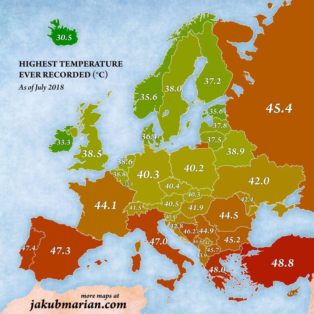
    Highest recorded temperature by country in Europe - although the UK got a record of 38.7 degrees earlier this year so it needs to be updated

    DjyqKJ3XgAA8B_F.jpg


  • Advertisement
  • Banned (with Prison Access) Posts: 9,078 ✭✭✭IAMAMORON


    The Irish one was recorded in Kilkenny castle in 1887... so much for climate change.


  • Registered Users, Registered Users 2 Posts: 3,438 ✭✭✭davetherave


    Sir Oxman wrote: »
    is that on sale framed or unframed?
    that'd look great on the wall.

    https://www.etsy.com/ie/listing/639734499/river-basins-of-the-island-of-ireland-in?ga_search_query=ireland&ref=shop_items_search_2&crt=1

    This guys etsy shop seems to be the source. It would make a great print alright.


  • Registered Users, Registered Users 2 Posts: 11,300 ✭✭✭✭Father Hernandez


    Great spot, Christmas stocking filled.


  • Posts: 7,712 ✭✭✭ [Deleted User]


    I can’t fully work out, but is that just for the digital download? Is there a printed version to buy?


  • Moderators, Social & Fun Moderators Posts: 12,887 Mod ✭✭✭✭JupiterKid


    Emerging Mega-regions of Urban Development and Influence in the USA

    VaszE.png


  • Moderators, Social & Fun Moderators Posts: 12,887 Mod ✭✭✭✭JupiterKid


    Religious Identity Map of Greater London

    lsxl98wyxam11.jpg


  • Registered Users, Registered Users 2 Posts: 1,863 ✭✭✭dball


    Great spot, Christmas stocking filled.

    You'll receive a digital, ultra-high resolution 9933 x 14043 pixel PNG image, perfect for printing on canvases, paper, metals, wood or glass. It can be printed up to 33.1 x 46.8 inches (84.1 x 118.9 cm), 300 dpi.


  • Closed Accounts Posts: 20,633 ✭✭✭✭Buford T. Justice XIX


    Mod note: This thread might be better served by going to the Geography forum so I'll close this up for now and transfer to that forum.

    Thanks to all for your contributions here and please note the change of forum and forum rules before you post on this thread again.

    Buford T. Justice.


  • Moderators, Science, Health & Environment Moderators Posts: 5,221 Mod ✭✭✭✭slowburner


    Mod note:

    A gentle reminder that this is a science forum and not After Hours.
    Inappropriate posts will be treated accordingly.


    (...and apologies for the delay in opening this interesting thread)


  • Advertisement
  • Banned (with Prison Access) Posts: 391 ✭✭Professor Genius


    slowburner wrote: »
    Mod note:

    A gentle reminder that this is a science forum and not After Hours.
    Inappropriate posts will be treated accordingly.


    (...and apologies for the delay in opening this interesting thread)

    Can you move this back to AH?

    https://touch.boards.ie/thread/2058006749/6/#post112013408


  • Moderators, Category Moderators, Science, Health & Environment Moderators, Society & Culture Moderators, Regional East Moderators, Regional Midlands Moderators, Regional Midwest Moderators, Regional Abroad Moderators, Regional North Mods, Regional West Moderators, Regional South East Moderators, Regional North East Moderators, Regional North West Moderators, Regional South Moderators Posts: 9,300 CMod ✭✭✭✭Fathom


    Pangaea map.


  • Moderators, Science, Health & Environment Moderators Posts: 5,221 Mod ✭✭✭✭slowburner


    It's a good thread, suited to this forum and a welcome breath of life too, so if you don't mind...


  • Moderators, Category Moderators, Science, Health & Environment Moderators, Society & Culture Moderators Posts: 47,335 CMod ✭✭✭✭Black Swan


    Ancient history of Ireland in maps. Eire was landlocked to continental Europe during Ice Age.


  • Posts: 0 [Deleted User]


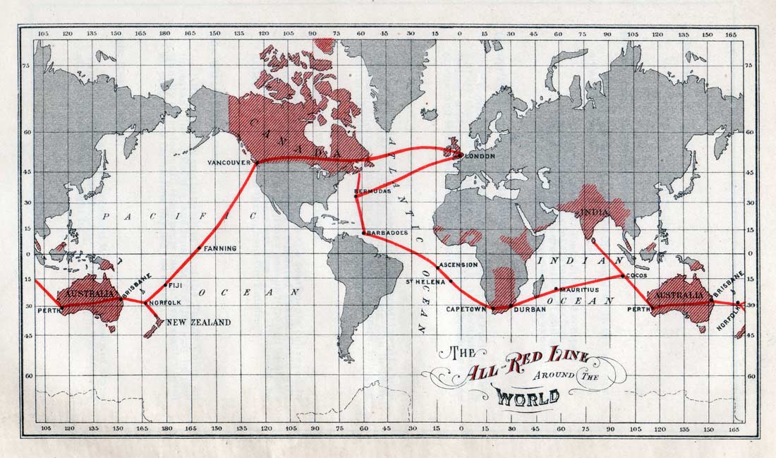
    1902AllRedLineMap.jpg

    The All Red Line was an informal name for the system of electrical telegraphs that linked much of the British Empire. It was inaugurated on 31 October 1902. The name derives from the common practice of colouring the territory of the British Empire red or pink on political maps. (Source Wikipedia)


  • Hosted Moderators Posts: 11,362 ✭✭✭✭Scarinae


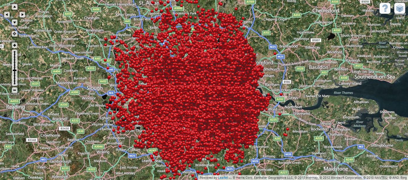
    A map of all the bombs that fell on London during the Blitz, October 1940-June 1941

    Aggregate-of-all-the-bombs.jpg


  • Advertisement
  • Registered Users, Registered Users 2 Posts: 13,681 ✭✭✭✭Deja Boo


    slowburner wrote: »
    Mod note:

    A gentle reminder that this is a science forum and not After Hours.
    Inappropriate posts will be treated accordingly.


    (...and apologies for the delay in opening this interesting thread)

    Some of the maps aren't science related, per se, just interesting and enjoyable. Given the move and directive, some (including myself) would hesitate to post amusing maps in a strictly science-related forum :( ...was an engaging AH thread while it lasted though.


  • Banned (with Prison Access) Posts: 391 ✭✭Professor Genius


    slowburner wrote: »
    It's a good thread, suited to this forum and a welcome breath of life too, so if you don't mind...

    I do mind actually because it will be tumbleweed in this dead forum and the thread will die. How many follow this forum v afterhours. The mod who move this admitted his mistake on the thread I linked.


  • Closed Accounts Posts: 8,492 ✭✭✭Sir Oxman


    Thanks for that!


  • Registered Users, Registered Users 2 Posts: 2,598 ✭✭✭rizzodun


    The people of Europe have voted.

    497660.jpg


  • Moderators, Science, Health & Environment Moderators Posts: 5,221 Mod ✭✭✭✭slowburner


    Deja Boo wrote: »
    Some of the maps aren't science related, per se, just interesting and enjoyable. Given the move and directive, some (including myself) would hesitate to post amusing maps in a strictly science-related forum :( ...was an engaging AH thread while it lasted though.
    Work away...


  • Advertisement
  • Posts: 0 [Deleted User]


    23052019%20-%20firuir_upper_airspace_ectl.pdf

    Map of upper airspace in/over Europe


  • Posts: 0 [Deleted User]


    a-aag.jpg

    Areas of Ireland most at risk of sinkholes


  • Posts: 0 [Deleted User]


    airspace-infringements-web1.png?sfvrsn=968e05f3_0

    Airspace infringements in the Dublin area


  • Registered Users, Registered Users 2 Posts: 13,681 ✭✭✭✭Deja Boo


    slowburner wrote: »
    Work away...

    Thanks, but my maps would probably be considered inappropriate in a Science forum.


  • Registered Users, Registered Users 2 Posts: 5,200 ✭✭✭hots


    Any chance of a Geography mod sending this back to AH? Was a really interesting & lively thread before it was locked and moved.


  • Moderators, Politics Moderators Posts: 40,288 Mod ✭✭✭✭Seth Brundle


    These should be taught in school! :D
    (images too large to embed here)
    French wine regionsm - https://vinmaps.com/wp-content/uploads/2015/10/Vinmaps-France-2015-1-new.jpg
    Western Europe Wine Arc - https://www.bridgewaterwines.com/web/wpc/uploads/Vinmaps-Europe-2015-FILEminimizer.jpg


  • Moderators, Politics Moderators Posts: 40,288 Mod ✭✭✭✭Seth Brundle


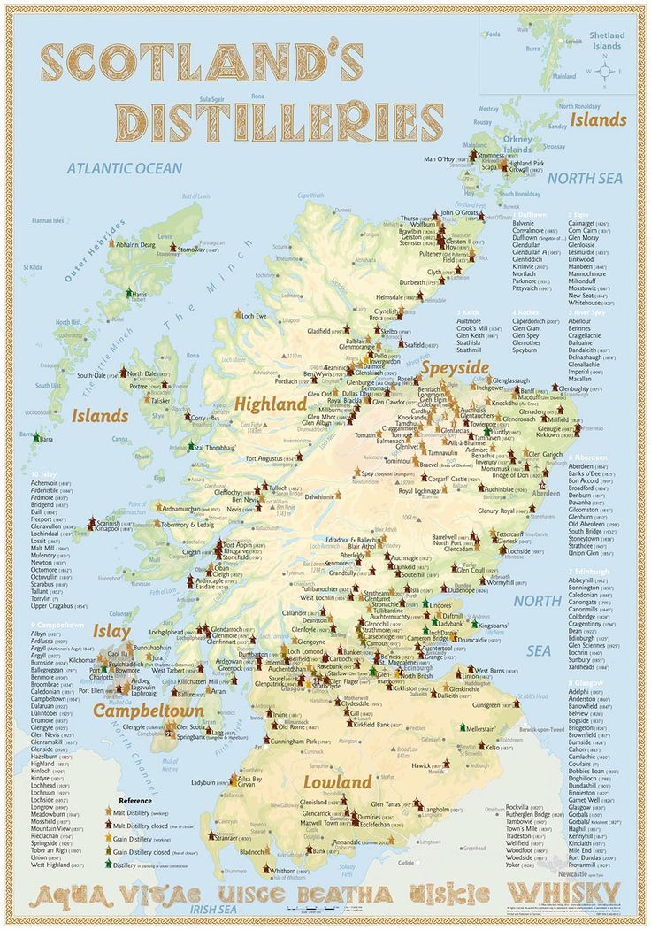
    99153e2cfe4d3cebc8be07c347be3dbe.jpg


    Whiskymap.jpg


  • Moderators, Politics Moderators Posts: 40,288 Mod ✭✭✭✭Seth Brundle


    I'm sure there are loads more than this but anyhow it is supposedly Ireland's Distilleries and Breweries...
    sketch-1528498291001.png


  • Administrators, Social & Fun Moderators, Sports Moderators Posts: 77,505 Admin ✭✭✭✭✭Beasty


    Thread returned from a Geography trip


  • Registered Users, Registered Users 2 Posts: 5,985 ✭✭✭Princess Calla


    It's back!!!


  • Advertisement
Advertisement