Advertisement
If you have a new account but are having problems posting or verifying your account, please email us on hello@boards.ie for help. Thanks :)
Hello all! Please ensure that you are posting a new thread or question in the appropriate forum. The Feedback forum is overwhelmed with questions that are having to be moved elsewhere. If you need help to verify your account contact hello@boards.ie

Hurricane IRENE

Options
1246711

Comments

  • Registered Users Posts: 232 ✭✭gihj


    TWC are saying only 3 inches of rain would be enough to cause inland flooding in some Mid Atlantic / New England areas because the ground is so saturated. They are calling for rainfall up to 12-14 inches from Irene.

    They are expecting "massive, terrible" inland flooding.

    3 inches is quite probable but 12 is hardly likely.
    Luckily they won't have to deal with the storm surge that looks destined for further south.


  • Registered Users Posts: 320 ✭✭tomcosgrave


    Starting to get really worried for the property of family and friends there. :(


  • Registered Users Posts: 14,352 ✭✭✭✭M.T. Cranium


    Hello, back from holiday and tracking Irene closely.

    The current NHC track is very similar to the 1821 hurricane which is always referenced as a near-worst-case scenario for NYC, NJ and western LI. Back then, development was restricted to a few harbours but enough is known of those impacts to give us reasonable guidance on what to expect from a repeat in modern times. There would be substantial damage to shoreline areas and swaths of moderate to catastrophic damage to inland buildings on the "forward" side of the track. There would also be catastrophic flooding potential along and to the west of the track.

    A shift slightly east would mean central to eastern Long Island and most of New England would get these impacts and the heavier rain would fall in the Hudson valley and NYC. To some extent, that would be better for the rain situation as those regions could handle a heavier rainfall better than flat, low-lying NJ and parts of the Delmarva.

    A shift slightly west would place all of Chesapeake Bay and therefore eastern VA, DC and MD in direct danger of severe storm surge flooding as the south to southeast winds would then pile up 15-20 foot storm surge waves into the Bay, worse than Isobel in 2003. This shift would also imply greater impacts in NC and southeast VA.

    My hunch at the moment is a slight eastward shift bringing the hurricane almost directly over Cape Hatteras then slightly offshore up the east coast to a second landfall east of JFK somewhere around Babylon or Westhampton on Long Island. This would be similar to Gloria (1985) and therefore CT and RI as well as eastern MA would be likely to see major impacts.

    At present, the range of possible outcomes would range from a total miss with minor effects, to a severe catastrophic hit. The larger regional steering currents are not so strong that we can be very confident on track but as the models have converged on a narrow range, it seems likely that a complete miss is not in the cards (and a complete miss just means that Nova Scotia in eastern Canada would get the hurricane).


  • Closed Accounts Posts: 2,693 ✭✭✭Redsunset


    Historic hurricanes

    Since records have been kept in the 1700s, dozens of hurricanes have passed through the greater New York City area, including a few major hurricanes.

    On Sept. 3, 1821, a major hurricane slammed without warning into Manhattan, flooding everything south of Canal Street, according to historical accounts. The East River and the Hudson River converged over Lower Manhattan, but that part of the island had not yet been built up. Had the storm hit at high tide, the flooding would have been far worse, researchers say.

    The benchmark by which all New York hurricane fears are measured is the so-called Long Island Express. Late in the summer of 1938, a storm that started off the coast of Africa arrived unexpectedly along the coast of New Jersey, where 140 mph (225 kph) winds tore up boardwalks. The storm raced north at more than 50 mph and uprooted trees and destroyed houses on Long Island. A U.S. Coast Guard station on Long Island measured a minimum pressure of 27.94 inches. Storm surges of 10 to 12 feet inundated portions of the coast from Long Island and Connecticut eastward to southeastern Massachusetts.

    The 1938 storm showed just how dangerous storm surge can be in a bay. In Rhode Island, at the head of Narragansett Bay 30 miles from the Atlantic, the city of Providence awaited a fate its inhabitants could not have imagined. As the hurricane barreled toward the city, it pushed a surge of water up the bay. As the channel narrowed and became more shallow, the storm surge had nowhere to go but up. The mountain of water carried boats and houses into the capital, flooding the first floor of buildings in downtown, where workers were just preparing to go home.

    The storm moved so quickly northward from North Carolina that it caught everyone by surprise. Since no warnings were issued, people fled only when they saw the storm approaching, and an estimated 682 to 800 people were killed, according to "Sudden Sea: The Great Hurricane of 1938" (Back Bay, 2004).

    More recently, Hurricane Carol made landfall as a Category 3 storm on Long Island and Connecticut in 1954. In 1960, Hurricane Donna created an 11-foot (3.4-meter) storm surge in New York Harbor, causing extensive pier damage, according to the New York City Office of Emergency Management.

    Hurricane Gloria in 1985 would have been "catastrophic" if it had hit at high tide and been just slightly closer to the city. As it was, it did several hundred million dollars' worth of damage, washing away piers and docks and destroying a few homes on the ocean-facing side of the island. There have been several other near-misses in the past six decades.

    It's hard to say if Hurricane Irene will smack New York City, but history suggests it is only a matter of time before a major hurricane makes a direct hit.


  • Registered Users Posts: 11,134 ✭✭✭✭maquiladora


    Hello, back from holiday and tracking Irene closely.

    Welcome back MT! Have you seen this article by Dr Masters? Storm surge could be really awful depending on exact track/intensity.

    http://www.wunderground.com/blog/JeffMasters/comment.html?entrynum=1899


  • Advertisement
  • Registered Users Posts: 232 ✭✭gihj


    Hello, back from holiday and tracking Irene closely.

    The current NHC track is very similar to the 1821 hurricane which is always referenced as a near-worst-case scenario for NYC, NJ and western LI. Back then, development was restricted to a few harbours but enough is known of those impacts to give us reasonable guidance on what to expect from a repeat in modern times. There would be substantial damage to shoreline areas and swaths of moderate to catastrophic damage to inland buildings on the "forward" side of the track. There would also be catastrophic flooding potential along and to the west of the track.

    A shift slightly east would mean central to eastern Long Island and most of New England would get these impacts and the heavier rain would fall in the Hudson valley and NYC. To some extent, that would be better for the rain situation as those regions could handle a heavier rainfall better than flat, low-lying NJ and parts of the Delmarva.

    A shift slightly west would place all of Chesapeake Bay and therefore eastern VA, DC and MD in direct danger of severe storm surge flooding as the south to southeast winds would then pile up 15-20 foot storm surge waves into the Bay, worse than Isobel in 2003. This shift would also imply greater impacts in NC and southeast VA.

    My hunch at the moment is a slight eastward shift bringing the hurricane almost directly over Cape Hatteras then slightly offshore up the east coast to a second landfall east of JFK somewhere around Babylon or Westhampton on Long Island. This would be similar to Gloria (1985) and therefore CT and RI as well as eastern MA would be likely to see major impacts.

    At present, the range of possible outcomes would range from a total miss with minor effects, to a severe catastrophic hit. The larger regional steering currents are not so strong that we can be very confident on track but as the models have converged on a narrow range, it seems likely that a complete miss is not in the cards (and a complete miss just means that Nova Scotia in eastern Canada would get the hurricane).

    MTC, do you think that if it hits land in North Carolina (which is most likely now) that the strength would not be taken out of it and combined with cooler waters up north she should be much lesser strength by the time she reaches land again (if that's her track).


  • Closed Accounts Posts: 2,693 ✭✭✭Redsunset


    An Air Force Reserve hurricane hunter aircraft investigating Irene has found a slightly weaker storm. As of 4pm EDT, the strongest surface winds seen by the aircraft with their SFMR instrument were 91 mph in the storm's northeast eyewall. Highest winds measured at their flight level of 10,000 feet were 114 mph. Assuming the aircraft missed sampling the strongest winds of the hurricane, it's a good guess that Irene has fallen to Category 2 strength with 100 - 105 mph winds, even though the official advisory is higher.

    The aircraft noted that the eyewall was missing a large chunk on it southwest side, but the central pressure was about the same as early this morning, 950 mb. Satellite imagery from late this morning and early this afternoon showed a distinctly lopsided appearance to Irene's cloud pattern, with not much heavy thunderstorm activity on the southwest side. This was due to moderate wind shear of 10 - 20 knots due to upper-level winds out of the southwest. This shear was able to disrupt Irene's circulation while it was attempting to complete an eyewall replacement cycle, resulting in dry air getting wrapped into the core, which can be seen as a streak of darker clouds in this morning's MODIS satellite image satellite loops show that Irene is beginning to recover from this adversity, with a respectable amount of heavy thunderstorms beginning to wrap around to the southwest side from the north. An upper-level wind analysis from the University of Wisconsin CIMSS site shows that Irene's upper-level outflow is much more restricted than was the case 24 hours ago.

    An upper-level outflow channel that was open to the south is gone, and has been replaced by shearing winds from the west and southwest that are ripping into the hurricane. I think it is 30% likely that Irene will have trouble recovering from this setback, and will not reach the peak intensity of 120 mph winds it had earlier. However, it is more likely that the hurricane will be able to re-establish its upper-level outflow and overcome the shear, based on the latest satellite loops, plus forecasts from the various hurricane models such as the GFDL, HWRF, and ECMWF, which all show Irene at Category 3 strength as it approaches North Carolina on Saturday afternoon.


  • Registered Users Posts: 11,134 ✭✭✭✭maquiladora


    She is looking better. Should see her gaining strength soon.

    ztemp.png


  • Closed Accounts Posts: 23,316 ✭✭✭✭amacachi


    "better" = stronger?


  • Registered Users Posts: 232 ✭✭gihj


    She is looking better. Should see her gaining strength soon.

    ztemp.png

    Some weaknesses visible around the eye wall alright.After initial landfall (after some more strengthening first) she looks destined to lose most of that well defined organisation.I wouldn't want to be where she makes landfall though the good news is that will be the worst of it before she breaks up slowly


  • Advertisement
  • Registered Users Posts: 11,134 ✭✭✭✭maquiladora


    amacachi wrote: »
    "better" = stronger?

    In better shape to get stronger. We'll find out when the recon planes report back their findings.


  • Closed Accounts Posts: 4,584 ✭✭✭digme


    charlie looked way better :)


  • Registered Users Posts: 232 ✭✭gihj


    In better shape to get stronger. We'll find out when the recon planes report back their findings.

    Yes perhaps people could define "better" in their posts please.
    Better for a weather nerd is more destructive and more potential for loss of life for others.
    Important to not get too excited at times like these when lives are at stake.:rolleyes:

    Not directed at you Maq


  • Closed Accounts Posts: 4,584 ✭✭✭digme


    gihj wrote: »
    Yes perhaps people could define "better" in their posts please.
    Better for a weather nerd is more destructive and more potential for loss of life for others.
    Important to not get too excited at times like these when lives are at stake.:rolleyes:

    Not directed at you Maq
    This is the weather forum.


  • Registered Users Posts: 232 ✭✭gihj


    digme wrote: »
    This is the weather forum.

    Oops thanks.
    Thought i was posting in P.I. there for a while.


  • Registered Users Posts: 14,352 ✭✭✭✭M.T. Cranium


    The probable reduction in intensity after a landfall in NC depends on how long the forward half of the storm remains over land. If the landfall is glancing the storm may only lose one category briefly and could recover that east of the Delmarva. If the storm comes inland in central NC and the entire circulation stays over land for 24-36 hours then it would be very likely to reduce gradually from cat-3 (possibly) at landfall to cat-1 by eastern PA to strong TS in the Hudson valley. However, that's strong enough and considering momentum in the storm surge, still capable of producing a very significant and potentially devastating storm surge into Chesapeake Bay or further north.

    This graphic will show how a typical cat-3 hurricane actually plays out for a 200-mile wide cross section from west to east taken through the eye of the storm but showing the maximum sustained wind (as category of hurricane or tropical storm) rather than an instantaneous value. This eliminates the temporary lull in speed associated with the eye.


    (For hurricane moving north)


    scale

    100 miles west .......50 miles west ........ track of eye ...... 50 miles east ..... 100 miles east

    weak TS ....... strong TS ........ cat 1 ..... cat 2 ....... cat 3 ........ cat 2 ........ cat 1 ..


    You can see from that simplified graphic that the wind gradient on the west side of the track falls off faster than on the forward side. Land interactions could make this gradient even sharper. Storm surge is usually worst about 20 to 50 miles east of the track. Eyewall diameter factors into how far from the track the strongest winds are found, usually this would be 15-30 miles east of the track. The "back" side of the eyewall usually sees northerly winds about 2/3 the speed of the forward side southerly hurricane force winds.

    As you can see, this complicates the equation for NYC. A track inland will favour stronger winds hitting NYC but will weaken the storm faster. A track along the NJ coast will keep the storm stronger moving north. This is why a direct hit on JFK in southeast NYC is probably the worst case scenario for the city, unlike for any city further east where the worst case scenario is a track just to the west of that city.


  • Closed Accounts Posts: 4,584 ✭✭✭digme


    gihj wrote: »
    Oops thanks.
    Thought i was posting in P.I. there for a while.
    Don't get too excited,I'm sure it will get better and fizzle out.


  • Registered Users Posts: 232 ✭✭gihj


    digme wrote: »
    Don't get too excited,I'm sure it will get better and fizzle out.

    "Better"?
    What does better mean?
    You're not great at this game are ya?:D;)


  • Registered Users Posts: 11,134 ✭✭✭✭maquiladora


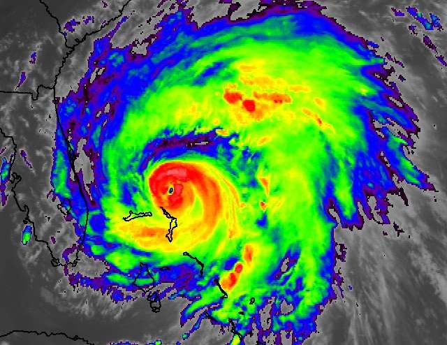
    You can see how large she is starting to get now.

    85907555.jpg


  • Closed Accounts Posts: 4,584 ✭✭✭digme


    :)


  • Advertisement
  • Registered Users Posts: 232 ✭✭gihj


    You can see how large she is starting to get now.

    85907555.jpg

    And plenty of time to intensify over warm waters yet.


  • Registered Users Posts: 11,134 ✭✭✭✭maquiladora


    Recon has found 944.5 mb, she's getting stronger.


  • Registered Users Posts: 108 ✭✭blacktalons


    Irene: Worst Effects on Northeast in 50 Years Possible

    sosnowski.pngBy Alex Sosnowski, Expert Senior Meteorologist

    Aug 25, 2011; 2:40 PM ET


    Share |


    300x200_08251612_ireneseverity.jpg
    There is potential for the worst hurricane impacts in 50 years along the northern part of the Atlantic Seaboard as Irene plows northward.
    The impacts on lives, property, commerce and travel will be serious.
    While Irene is not forecast to track as far west, nor as fast, as Hazel did in 1954, it will ride up along the mid-Atlantic coast in such a way as to inflict major damage in many coastal and some inland communities. In today's dollars, Hazel was a multi-billion-dollar storm and reached Category 4 at peak intensity.
    Irene will track farther east than Hazel, and farther west than Bob (1991). Meteorologist Heather Buchman compares Irene to storms in the past.
    300x221_08251551_picture%201.png
    While Irene is expected to weaken Saturday into Sunday after encountering cooler waters in northern latitudes, that will not happen fast enough to prevent serious problems from wind, rain and ocean water.
    If you live near the projected path of Irene, you are at risk for power outages, flooding problems and property damage with this storm.


    AccuTeam Irene is reporting live from Atlantic Beach, N.C.
    Power Outages
    Downed trees alone have potential to block many streets and secondary roads from eastern North Carolina northward to southeastern Quebec, running along the very heavily populated I-95 Northeast U.S. corridor.
    With saturated soil, water-logged, heavy trees will topple and break, as will tree limbs.
    When trees come down, they take power lines with them. There could be millions in the dark for hours and hundreds of thousands without power for days starting at the height of Irene, and in her wake.
    Some people could be without tap water as a result of the power being out.
    Flooding Rainfall
    Irene will bring serious flooding from heavy rain in the coastal mid-Atlantic and portions of New England. It is not a question, not a risk; it is a certainty.
    Many areas in the Northeast have been hit with record or near-record rainfall for the month of August, and a few are flirting with their wettest month ever. Rain from thunderstorms in advance of Irene will make matters worse.
    300x159_08251602_115911075(2).jpg
    This could be the scene in parts of the I-95 Northeast in the wake of Irene's rainfall. Photo by photos.com.
    The saturated state of the ground will mean that water has nowhere to go but into yards, streets, streams and rivers.
    The worst conditions will be in the stretch from the Delmarva northward through New Jersey, western New England and the Hudson Valley of New York. In part of this area, a foot of rain could fall over a 24- to 48-hour period.
    Coastal Flooding, Beach Erosion
    Serious coastal flooding and beach erosion are expected from North Carolina northward to Maine.
    In a specific sense, the exact degree of above-normal tides is tricky and highly variable due to the highly varied shapes of the coast, barrier islands and back bays.
    In a general sense, tides will average 2 to 4 feet above normal, but locally higher surge is likely with wave action on top of the mean level of the sea and open bays.
    If you get coastal flooding during a strong nor'easter, you will likely get flooding with Irene. Some barrier islands may be cut off for a time.
    Some beaches and boardwalks in the mid-Atlantic and southern New England could sustain damage so severe that they are un-repairable for the duration of the 2011 summer season.
    High Winds
    Many people along the Atlantic Seaboard probably have not experienced such a strong storm as we expect with Hurricane Irene. People in the path of Irene should stay indoors during the height of this storm.
    Some of the youngest of the crowd were not around for Floyd (1999), Fran (1996), Gloria (1985) and others. Then there are the storms of the more distant generations of the 1960s and 1950s, which include Donna (1960), Diane (1955) and Hazel (1954).
    300x199_08251604_90700682.jpg
    While conditions are likely to be much less severe than this even in most coastal areas, falling trees could crash into homes, block intersections and cut power. Photo by photos.com.
    In addition to the potential for a great number of downed trees and power lines, Irene can cause other property issues ranging from damaged roofs and siding to busted windows. These items, and others knocked loose, will become airborne projectiles.
    High winds will affect air travel and high-profile vehicles in the path of Irene.
    There are many bridges that reach sky-high in the major port cities. The higher up you are, the stronger the winds will be. Travel over these bridges for a time at the height of Irene could be halted.
    We can only hope that people heed warnings and get out of harm's way in advance of Irene.
    Keep checking in at AccuWeather.com as there may be further adjustments to Irene's path in the north, as the two-way impact between the hurricane and other weather systems becomes clearer.


  • Closed Accounts Posts: 23,316 ✭✭✭✭amacachi


    That Ocean City place looks like a model designed to be wrecked in a storm surge simulation.


  • Registered Users Posts: 293 ✭✭eilejh


  • Registered Users Posts: 293 ✭✭eilejh


    Saffir-Simpson Hurricane Wind Scale explains how damaging the different Categories can be........

    http://www.nhc.noaa.gov/sshws.shtml


  • Closed Accounts Posts: 2,693 ✭✭✭Redsunset


    3-D view of Irene captured on August 24 by The Tropical Rainfall Measuring Mission (or TRMM) satellite ,the storm revealed the presence of a deep convective tower within the eyewall. The red area indicates rainfall rates of 50mm/hr (~2 inches), while yellow and green areas indicate moderate rainfall between .78 to 1.57 inches (20-40 mm) per hour.
    Credit: SSAI/NASA, Hal Pierce


    582132main_20110825_IreneTRMM3D2_full.jpg


  • Registered Users Posts: 293 ✭✭eilejh


  • Registered Users Posts: 293 ✭✭eilejh


    000
    UZNT13 KWBC 260217
    XXAA 76028 99278 70774 08077 99942 28020 18005 00/// ///// /////
    92165 26613 14006 85912 22811 13506 88999 77999
    31313 09608 80158
    51515 10167 07775
    61616 NOAA2 2309A IRENE OB 34
    62626 REL 2782N07735W 015814 SPG 2783N07736W 020106 WL150 14506 0
    85 DLM WND 14504 941752 MBL WND 14506 EYE=

    XXBB 76028 99278 70774 08077 00942 28020 11924 26613 22848 22810
    33798 22044 44752 20238
    21212 00942 18005 11940 18003 22939 13008 33752 13003
    31313 09608 80158
    51515 10167 07775
    61616 NOAA2 2309A IRENE OB 34
    62626 REL 2782N07735W 015814 SPG 2783N07736W 020106 WL150 14506 0
    85 DLM WND 14504 941752 MBL WND 14506 EYE=


  • Advertisement
  • Registered Users Posts: 293 ✭✭eilejh


Advertisement