Advertisement
If you have a new account but are having problems posting or verifying your account, please email us on hello@boards.ie for help. Thanks :)
Hello all! Please ensure that you are posting a new thread or question in the appropriate forum. The Feedback forum is overwhelmed with questions that are having to be moved elsewhere. If you need help to verify your account contact hello@boards.ie
Hi there,
There is an issue with role permissions that is being worked on at the moment.
If you are having trouble with access or permissions on regional forums please post here to get access: https://www.boards.ie/discussion/2058365403/you-do-not-have-permission-for-that#latest

Hurricane IRENE

  • 20-08-2011 11:57pm
    #1
    Registered Users, Registered Users 2 Posts: 330 ✭✭


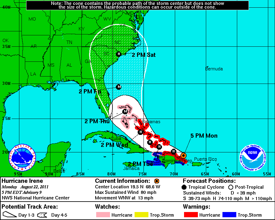
    This is has just been declared by the NHC and they are presently suggesting that it will become a hurricane just before it passes over Hispaniola. This would make it the first hurricane of the 2011 Atlantic season, but it would appear it wouldn't remain as one for long, based on the current forecast - there's too much land, so if it makes Florida along the present model, it should be as a tropical storm.

    230313W5_NL_sm.gif


«134567

Comments

  • Registered Users, Registered Users 2 Posts: 7,468 ✭✭✭Evil Phil


    We are 336 miles NW of the center and it is lashing rain. Power went out for about an hour but is back now (not that is weather news). Lots of lightening, if it hasn't moved on too far once the sun rises I'll try post some photos.

    Follow it on twitter #irene, I'm going to use #skirene also as I'm in St Kitts.


  • Registered Users, Registered Users 2 Posts: 293 ✭✭eilejh


  • Registered Users, Registered Users 2 Posts: 11,134 ✭✭✭✭maquiladora


    12Z GFS misses Florida, slams into Georgia.

    2cqxrsx.gif


  • Registered Users, Registered Users 2 Posts: 11,134 ✭✭✭✭maquiladora


    HWRF also misses Florida. Sends Irene into South Carolina as a major hurricane at landfall.

    15n7uix.gif


  • Closed Accounts Posts: 1,530 ✭✭✭TheInquisitor


    My god 933 pressure that would be a devastating hurricane!


  • Advertisement
  • Closed Accounts Posts: 5,234 ✭✭✭thetonynator


    My god 933 pressure that would be a devastating hurricane!

    Big difference between he 933 on one chart and 974 on the other . . .


  • Registered Users, Registered Users 2 Posts: 11,134 ✭✭✭✭maquiladora


    My god 933 pressure that would be a devastating hurricane!

    It could even end up being deeper than that. Or way weaker.

    Mostly depends on the exact track she takes due to land interaction (islands). The more land the core passes over the weaker it will become, esp high terrain. Though she could rapidly restrengthen again then beyond the islands if she gets to spend enough time over some of that very, very warm water.

    Worrying days ahead first for the Islanders and then later for coastal residents in the US.


  • Registered Users, Registered Users 2 Posts: 148 ✭✭dmaprelude


    Fantastic! I'm flying to Florida on Saturday :)


  • Registered Users, Registered Users 2 Posts: 11,134 ✭✭✭✭maquiladora


  • Registered Users, Registered Users 2 Posts: 5,475 ✭✭✭drkpower


    Im in Florida in 2 weeks:eek:.

    Does the fact that there has been a recent 'big one' mean that a 'big one' when I am there less likely?

    (or is that ridiculous wishful thinking.....?!)


  • Advertisement
  • Closed Accounts Posts: 3,548 ✭✭✭Harps


    The storms this season have been weak so far and September is the peak of the season so chances are there'll be a big storm during the month.


  • Registered Users, Registered Users 2 Posts: 11,134 ✭✭✭✭maquiladora


    0Z HWRF showing a high end Cat 4, maybe even Cat 5 about to make landfall, Georgia/S Carolina.

    Would be catastropic if that came off. Hopefully this changes.

    2v13yvt.gif


  • Registered Users, Registered Users 2 Posts: 11,134 ✭✭✭✭maquiladora


    ...IRENE STRENGTHENS OVER PUERTO RICO...BECOMING THE FIRST HURRICANE OF THE 2011 ATLANTIC SEASON...

    So much for land interaction weakening her. She has actually become a hurricane while still over Puerto Rico.

    Upgraded intensity from the NHC, but some models are showing it a lot stronger at landfall.

    at201109_5day.gif


  • Registered Users, Registered Users 2 Posts: 1,326 ✭✭✭snowstreams


    Looks like its eyeing up Savannah Georgia. They havent had a hurricane in a long time. Could do alot of damage anywhere along Georgia or the Carolinas though if its as low as 924! :eek:


  • Registered Users, Registered Users 2 Posts: 11,134 ✭✭✭✭maquiladora


    From the official forcast :
    SIGNIFICANT STRENGTHENING COULD OCCUR. HOWEVER...THE OFFICIAL INTENSITY WILL REMAIN ON THE CONSERVATIVE SIDE DUE TO THE UNCERTAINTY IN HOW MUCH IRENE WILL INTERACT WITH THE MOUNTAINOUS TERRAIN OF HISPANIOLA FOR THE NEXT 24-36 HOURS. THE OFFICIAL INTENSITY FORECAST IS A BLEND OF
    THE SHIPS/LGEM MODELS AND THE HWRF/GFDL MODELS. HOWEVER...GIVEN THE
    IMPRESSIVE UPPER-LEVEL FLOW PATTERN EXPECTED ACROSS IRENE...IT
    WOULD NOT SURPRISE ME IF THIS CYCLONE BECAME A MAJOR HURRICANE AT
    SOME TIME DURING ITS LIFETIME LIKE THE GFDL AND HWRF MODELS ARE
    FORECASTING.

    She was dangerous for Puerto Rico even at this early stage :

    PRELIMINARY REPORTS INDICATE THAT WIDESPREAD TREE AND POWERLINE
    DAMAGE HAS OCCURRED ON PUERTO RICO...AND MORE THAN 800 THOUSAND
    HOMES ARE WITHOUT POWER ON THE ISLAND.

    ALSO...FAA DOPPLER WEATHER RADAR INDICATES WINDS TO NEAR MAJOR
    HURRICANE STRENGTH ARE NOW OCCURRING IN THE HIGHER ELEVATIONS OF
    THE INTERIOR MOUNTAINOUS REGIONS OF PUERTO RICO.

    $$
    FORECASTER STEWART
    Update Statement From NHC


  • Registered Users, Registered Users 2 Posts: 11,134 ✭✭✭✭maquiladora


    NHC now forecasting Irene to deepen to a major hurricane, Cat 3, over Bahamas on Thursday with a Cat 3 landfall in S Carolina on Saturday.

    at201109_5day.gif


  • Registered Users, Registered Users 2 Posts: 11,134 ✭✭✭✭maquiladora


    Models are all over the place. Some models have shifted east, some have shifted west.

    The latest model out is the GFDL and its horrific.

    Borderline Cat 5 landfall south Florida. Unbelievable.

    12zgfdl2500mbhghtpmsl09.gif

    Floridians will be thankful this is the only model currently showing anything like this.


  • Registered Users, Registered Users 2 Posts: 10,528 ✭✭✭✭dsmythy


    hurrire.gif


  • Closed Accounts Posts: 5,234 ✭✭✭thetonynator


    Still some hope it could veer away and miss Florida and georgia as a major hurricane. . . wishful thinking maybe?!


  • Registered Users, Registered Users 2 Posts: 12 damiansynnott


  • Advertisement
  • Registered Users, Registered Users 2 Posts: 11,134 ✭✭✭✭maquiladora


    Latest HWRF run has shifted closer to Florida.

    Cat 5 just off the east Florida coast, would be serious storm surge and hurricane force winds all up along the Florida coast there, and then a major landfall into Georgia. Not a good run....

    18zhwrf500mbhghtpmslnes.gif


  • Registered Users, Registered Users 2 Posts: 11,134 ✭✭✭✭maquiladora


    Still some hope it could veer away and miss Florida and georgia as a major hurricane. . . wishful thinking maybe?!

    There is very much a chance she could still recurve without making landfall in the US, some models showed that today.

    The latest models have been showing a slight shift to the west though. Will have to wait for tomorrows models I think.


  • Registered Users, Registered Users 2 Posts: 2,735 ✭✭✭Rougies


    Latest HWRF run has shifted closer to Florida.

    Cat 5 just off the east Florida coast, would be serious storm surge and hurricane force winds all up along the Florida coast there, and then a major landfall into Georgia. Not a good run....

    And that's from a model that supposedly usually has a east biased track. Along with the slight westwards shift from other models, Irene is starting to look like a very dangerous hurricane. GFDL should be interesting.


  • Registered Users, Registered Users 2 Posts: 11,134 ✭✭✭✭maquiladora


    The GFDL destroys south Florida, then by this stage the core of the storm is halfway up the middle of the peninsula and its still a major hurricane. You can't even see Florida under Irene here.

    18zgfdl2500mbhghtpmsl10.gif

    I really don't think were going to see an outcome like these. So extreme.

    Meanwhile, right now :
    ...IRENE NOW A CATEGORY TWO HURRICANE...


  • Registered Users, Registered Users 2 Posts: 1,206 ✭✭✭eskimocat


    Certainly one to watch! Thanks for the updates folks! Keep them comin!


  • Registered Users, Registered Users 2 Posts: 11,134 ✭✭✭✭maquiladora


    NHC has upgraded intensity, expected to reach Cat 4 status on Thursday.

    Models are trending to the east so Florida may be in the clear.

    Starting to look more like an east coast or even north east coast storm now. However if the models keep trending east Irene could end up missing the US east coast and recurving out to sea.


  • Registered Users, Registered Users 2 Posts: 1,740 ✭✭✭Faolchu


    I'm flying out to Tampa on Thursday morning :(


    Bay News 9 just posted the following on Twitter:

    Hurricane Irene is near the Dominican Republic this morning. Winds 100
    mph. Moving WNW at 12 mph. Could become a major hurricane by tonight.


    Latest advisory from the NHC is here
    000
    WTNT34 KNHC 230832
    TCPAT4

    BULLETIN
    HURRICANE IRENE ADVISORY NUMBER 12
    NWS NATIONAL HURRICANE CENTER MIAMI FL AL092011
    500 AM EDT TUE AUG 23 2011

    ...IRENE LASHING THE NORTHERN COAST OF THE DOMINICAN REPUBLIC...
    EXPECTED TO MOVE OVER THE TURKS AND CAICOS LATER TODAY...


    SUMMARY OF 500 AM EDT...0900 UTC...INFORMATION
    LOCATION...20.3N 70.1W
    ABOUT 105 MI...170 KM SE OF GRAND TURK ISLAND
    ABOUT 50 MI...85 KM NE OF PUERTO PLATA DOMINICAN REPUBLIC
    MAXIMUM SUSTAINED WINDS...100 MPH...160 KM/H
    PRESENT MOVEMENT...WNW OR 295 DEGREES AT 12 MPH...19 KM/H
    MINIMUM CENTRAL PRESSURE...978 MB...28.88 INCHES


    WATCHES AND WARNINGS
    CHANGES IN WATCHES AND WARNINGS WITH THIS ADVISORY...

    NONE.

    SUMMARY OF WATCHES AND WARNINGS IN EFFECT...

    A HURRICANE WARNING IS IN EFFECT FOR...
    * NORTH COAST OF THE DOMINICAN REPUBLIC FROM THE HAITI BORDER
    EASTWARD TO CABO ENGANO
    * TURKS AND CAICOS ISLANDS...SOUTHEASTERN AND CENTRAL BAHAMAS

    A HURRICANE WATCH IS IN EFFECT FOR...
    * NORTH COAST OF HAITI FROM LE MOLE ST. NICHOLAS EASTWARD TO THE
    DOMINICAN REPUBLIC BORDER
    * NORTHWESTERN BAHAMAS

    A TROPICAL STORM WARNING IS IN EFFECT FOR...
    * SOUTH COAST OF THE DOMINICAN REPUBLIC FROM SANTO DOMINGO EASTWARD
    TO CABO ENGANO
    * ALL OF HAITI

    FOR STORM INFORMATION SPECIFIC TO YOUR AREA...PLEASE MONITOR
    PRODUCTS ISSUED BY YOUR NATIONAL METEOROLOGICAL SERVICE.


    DISCUSSION AND 48-HOUR OUTLOOK
    AT 500 AM AST...0900 UTC...THE CENTER OF HURRICANE IRENE WAS LOCATED
    NEAR LATITUDE 20.3 NORTH...LONGITUDE 70.1 WEST. IRENE IS MOVING
    TOWARD THE WEST-NORTHWEST NEAR 12 MPH...19 KM/H. THIS GENERAL MOTION
    IS EXPECTED TO CONTINUE THROUGH TODAY...FOLLOWED BY A TURN TOWARD
    THE NORTHWEST TUESDAY NIGHT AND WEDNESDAY. ON THE FORECAST TRACK...
    THE CORE OF IRENE WILL PASS TO THE NORTH OF THE DOMINICAN REPUBLIC
    AND HAITI THIS MORNING...NEAR OR OVER THE TURKS AND CAICOS ISLANDS
    AND THE SOUTHEASTERN BAHAMAS BY TONIGHT...AND BE NEAR THE CENTRAL
    BAHAMAS EARLY WEDNESDAY.

    MAXIMUM SUSTAINED WINDS REMAIN NEAR 100 MPH...160 KM/H...WITH HIGHER
    GUSTS. IRENE IS A CATEGORY TWO HURRICANE ON THE SAFFIR-SIMPSON
    HURRICANE WIND SCALE. ADDITIONAL STRENGTHENING IS FORECAST DURING
    THE NEXT 48 HOURS...AND IRENE COULD BECOME A MAJOR HURRICANE LATER
    TODAY OR ON WEDNESDAY.

    HURRICANE-FORCE WINDS EXTEND OUTWARD UP TO 50 MILES...85 KM...FROM
    THE CENTER...AND TROPICAL-STORM-FORCE WINDS EXTEND OUTWARD UP TO 205
    MILES...335 KM. EARLIER THIS MORNING...A SUSTAINED WIND OF 58 MPH...
    93 KM/H WAS REPORTED AT PUERTO PLATA DOMINICAN REPUBLIC.

    ESTIMATED MINIMUM CENTRAL PRESSURE IS 978 MB...28.88 INCHES.


    HAZARDS AFFECTING LAND
    WIND...TROPICAL STORM CONDITIONS WILL CONTINUE TO SPREAD OVER THE
    NORTHERN PORTIONS OF DOMINICAN REPUBLIC THIS MORNING AND INTO THE
    AFTERNOON...AND LOCALIZED HURRICANE CONDITIONS ARE EXPECTED OVER
    THE NORTHERN PORTIONS OF THE DOMINICAN REPUBLIC THIS MORNING. THE
    HIGHEST WINDS ARE LIKELY TO OCCUR OVER AREAS OF ELEVATED TERRAIN.
    TROPICAL STORM CONDITIONS ARE EXPECTED TO REACH THE SOUTHEASTERN
    BAHAMAS AND THE TURKS AND CAICOS ISLANDS LATER THIS MORNING WITH
    HURRICANE CONDITIONS EXPECTED BY THIS AFTERNOON AND EVENING.
    TROPICAL STORM CONDITIONS ARE FORECAST TO REACH THE CENTRAL BAHAMAS
    LATE TONIGHT WITH HURRICANE CONDITIONS EXPECTED BY WEDNESDAY.
    TROPICAL STORM CONDITIONS ARE POSSIBLE IN THE NORTHWESTERN BAHAMAS
    BY LATE WEDNESDAY...WITH HURRICANE CONDITIONS POSSIBLE BY THURSDAY.

    RAINFALL...IRENE IS EXPECTED TO PRODUCE ADDITIONAL RAINFALL
    ACCUMULATIONS OF 2 TO 4 INCHES ACROSS PUERTO RICO. RAINFALL
    AMOUNTS OF 3 TO 6 INCHES ARE EXPECTED OVER NORTHERN HISPANIOLA...
    WITH ISOLATED MAXIMUM AMOUNTS OF UP TO 10 INCHES POSSIBLE OVER
    HIGHER TERRAIN. THESE RAINS COULD CAUSE LIFE-THREATENING FLASH
    FLOODS AND MUDSLIDES IN AREAS OF STEEP TERRAIN. RAINFALL
    ACCUMULATIONS OF 5 TO 10 INCHES ARE EXPECTED IN THE SOUTHEASTERN
    AND CENTRAL BAHAMAS...AND THE TURKS AND CAICOS ISLANDS.

    STORM SURGE...A STORM SURGE WILL RAISE WATER LEVELS BY AS MUCH AS
    9 TO 13 FEET ABOVE NORMAL TIDE LEVELS OVER THE SOUTHEASTERN AND
    CENTRAL BAHAMAS...AND THE TURKS AND CAICOS ISLANDS. STORM SURGE
    WILL ALSO RAISE WATER LEVELS BY AS MUCH AS 2 TO 4 FEET ABOVE NORMAL
    TIDE LEVELS ALONG THE ENTIRE COAST OF THE DOMINICAN REPUBLIC. NEAR
    THE COAST...THE SURGE WILL BE ACCOMPANIED BY LARGE AND DANGEROUS
    WAVES.


    NEXT ADVISORY
    NEXT INTERMEDIATE ADVISORY...800 AM EDT.
    NEXT COMPLETE ADVISORY...1100 AM EDT.

    $$
    FORECASTER STEWART


  • Registered Users, Registered Users 2 Posts: 11,134 ✭✭✭✭maquiladora


    Faolchu wrote: »
    I'm flying out to Tampa on Thursday morning :(

    The good news for you is that its looking more and more likely that she will miss Florida. Tampa is outside the cone now and the trend with the models is eastward.

    Could all change again but at the moment its looking like either an east coast landfall or the classic recurve out to sea.


  • Registered Users, Registered Users 2 Posts: 1,740 ✭✭✭Faolchu


    The good news for you is that its looking more and more likely that she will miss Florida. Tampa is outside the cone now and the trend with the models is eastward.

    .


    yeah but we also planned on doing a few days in Orlando which at the minute may still be in the path and our light is due to land in Orlando (MCO). I've been glued to the twitter fot NHC atlantic all through the night.

    fingeres crossed she heads back out to sea


  • Advertisement
  • Registered Users, Registered Users 2 Posts: 330 ✭✭tomcosgrave


    NHC just posted Advisory 12A, here's the essentials -

    SUMMARY OF 800 AM EDT...1200 UTC...INFORMATION
    LOCATION...20.6N 70.6W
    ABOUT 70 MI...110 KM SSE OF GRAND TURK ISLAND
    ABOUT 55 MI...90 KM N OF PUERTO PLATA DOMINICAN REPUBLIC
    MAXIMUM SUSTAINED WINDS...100 MPH...160 KM/H
    PRESENT MOVEMENT...WNW OR 295 DEGREES AT 10 MPH...17 KM/H
    MINIMUM CENTRAL PRESSURE...978 MB...28.88 INCHES

    DISCUSSION AND 48-HOUR OUTLOOK
    AT 800 AM EDT...1200 UTC...THE CENTER OF HURRICANE IRENE WAS LOCATED
    NEAR LATITUDE 20.6 NORTH...LONGITUDE 70.6 WEST. IRENE IS MOVING
    TOWARD THE WEST-NORTHWEST NEAR 10 MPH...17 KM/H. THIS GENERAL
    MOTION IS EXPECTED TO CONTINUE THROUGH TONIGHT...FOLLOWED BY A TURN
    TOWARD THE NORTHWEST ON WEDNESDAY. ON THE FORECAST TRACK...THE
    CORE OF IRENE WILL PASS TO THE NORTH OF THE DOMINICAN REPUBLIC AND
    HAITI THIS MORNING...NEAR OR OVER THE TURKS AND CAICOS ISLANDS AND
    THE SOUTHEASTERN BAHAMAS TONIGHT...AND BE NEAR THE CENTRAL BAHAMAS
    EARLY WEDNESDAY.

    MAXIMUM SUSTAINED WINDS ARE NEAR 100 MPH...160 KM/H...WITH HIGHER
    GUSTS. IRENE IS A CATEGORY TWO HURRICANE ON THE SAFFIR-SIMPSON
    HURRICANE WIND SCALE. ADDITIONAL STRENGTHENING IS FORECAST DURING
    THE NEXT 48 HOURS...AND IRENE COULD BECOME A MAJOR HURRICANE LATER
    TODAY OR ON WEDNESDAY.

    HURRICANE-FORCE WINDS EXTEND OUTWARD UP TO 50 MILES...85 KM...FROM
    THE CENTER...AND TROPICAL-STORM-FORCE WINDS EXTEND OUTWARD UP TO 205
    MILES...335 KM.

    ESTIMATED MINIMUM CENTRAL PRESSURE IS 978 MB...28.88 INCHES.


  • Registered Users, Registered Users 2 Posts: 11,134 ✭✭✭✭maquiladora


    Faolchu wrote: »
    yeah but we also planned on doing a few days in Orlando which at the minute may still be in the path and our light is due to land in Orlando (MCO). I've been glued to the twitter fot NHC atlantic all through the night.

    fingeres crossed she heads back out to sea

    I don't think there is any model taking Irene to Florida now today. There was some new data injected into the models from data collected by a Gulfsteam jet on a special mission around the area. Since then all the models (afaik) have shifted east.

    Keep your fingers crossed but at the moment there would need to be some dramatic changes for Florida to be in play again.

    storm_09

    Trend continuing east with every run, if this keeps up for a few more runs then the US eastcoat will be safe.

    fetchmap.php?what=models&year=2011&r=NT&eventnum=9&zoom=1&models=AVNO,AVNI,AP01,AP02,AP03,AP04,AP05,AP06,AP07,AP08,AP09,AP10,AP11,AP12,AP13,AP14,AP15,AP16,AP17,AP18,AP19,AP20,AEMN,BAMD,BAMM,BAMS,HWRF,HWFI,GFDL,GFDT,GFTI,NGPS,NGPI,NGX,NGXI,NGX2,CEMN,SHF5,SHIP,DSHP,MRCL,DRCL,XTRP,CLIP,CLP5,LBAR,MRFO


  • Registered Users, Registered Users 2 Posts: 330 ✭✭tomcosgrave


    NHC Advisory 13 is in. Looks like Florida is definitely out at this point and North Carolina will get the brunt - but it will still be a hurricane and will impact Virginia. Unless of course, the models pointing to a recurve out to see are proven accurate.
    000
    WTNT44 KNHC 231500
    TCDAT4

    HURRICANE IRENE DISCUSSION NUMBER 13
    NWS NATIONAL HURRICANE CENTER MIAMI FL AL092011
    1100 AM EDT TUE AUG 23 2011

    THE LAST FEW VISIBLE SATELLITE IMAGES SHOW A HINT OF AN EYE... WHILE
    RECENT MICROWAVE DATA SHOW AN EYEWALL THAT IS OPEN TO THE SOUTH.
    THE LATEST SATELLITE INTENSITY ESTIMATES FROM SAB AND TAFB WERE 77
    AND 90 KT...RESPECTIVELY...AND SUPPORT MAINTAINING AN INITIAL
    INTENSITY OF 85 KT. THE RECONNAISSANCE AIRCRAFT SCHEDULED TO
    INVESTIGATE IRENE THIS MORNING HAD ISSUES WITH THE ON-BOARD RADAR.
    THIS REQUIRED A CHANGE IN AIRCRAFT AND THE NEW PLANE JUST PASSED
    THROUGH THE CENTER...REPORTING A MINIMUM PRESSURE OF 980 MB...ABOUT
    THE SAME AS DURING THE PREVIOUS MISSION.

    A SHEAR ANALYSIS FROM UW-CIMSS SHOWS ABOUT 10-20 KT OF SOUTHWESTERLY
    SHEAR OVER IRENE....AND THE SHIPS GUIDANCE DOES NOT WEAKEN THIS
    SHEAR DURING THE NEXT COUPLE OF DAYS. AS A RESULT...THE SHIPS/LGEM
    MODELS DO NOT SHOW MUCH STRENGTHENING DURING THAT TIME. ON THE
    OTHER HAND...THE GFDL/HWRF MODELS ARE MUCH MORE AGGRESSIVE AND MAKE
    IRENE A MAJOR HURRICANE WITHIN 24 HOURS. THE NEW INTENSITY FORECAST
    IS HIGHER THAN THE STATISTICAL GUIDANCE...BUT NOT AS AGGRESSIVE AS
    THE GFDL/HWRF. THE UPDATED FORECAST IS SLIGHTLY BELOW THE PREVIOUS
    ADVISORY.

    IRENE HAS BEEN MOVING WEST-NORTHWESTWARD OR 295 DEGREES AT 10 KT. A
    MID/UPPER-LEVEL TROUGH MOVING OVER THE NORTHEASTERN UNITED STATES
    IS EXPECTED TO WEAKEN THE WESTERN PORTION OF THE SUBTROPICAL RIDGE
    DURING THE NEXT DAY OR SO. THIS SHOULD ALLOW IRENE TO TURN
    NORTHWESTWARD WITHIN THE NEXT 24-36 HOURS...AND THE TRACK GUIDANCE
    IS IN EXCELLENT AGREEMENT DURING THE FIRST 48 HOURS. LATER IN THE
    FORECAST PERIOD IRENE IS FORECAST TO TURN NORTHWARD AS IT ROUNDS
    THE WESTERN PORTION OF THE RIDGE. THE SPREAD IN THE GUIDANCE
    INCREASES BY DAY THREE...RANGING FROM THE COASTAL MID-ATLANTIC
    STATES TO WELL OFFSHORE...WITH THE UKMET ALONG THE LEFT SIDE AND
    THE GFS/NOGAPS ALONG THE RIGHT SIDE OF THE GUIDANCE ENVELOPE. THE
    UPDATED TRACK IS CLOSEST TO THE ECMWF AND IS A LITTLE LEFT OF THE
    MULTI-MODEL CONSENSUS. IT IS IMPORTANT TO REMIND USERS NOT TO FOCUS
    ON THE EXACT FORECAST TRACK...ESPECIALLY AT DAYS 4 AND 5...SINCE
    THE MOST RECENT 5-YEAR AVERAGE ERRORS AT THOSE FORECAST TIMES ARE
    200 AND 250 MILES...RESPECTIVELY.


    FORECAST POSITIONS AND MAX WINDS

    INIT 23/1500Z 20.5N 71.0W 85 KT 100 MPH
    12H 24/0000Z 21.3N 72.3W 90 KT 105 MPH
    24H 24/1200Z 22.3N 73.8W 100 KT 115 MPH
    36H 25/0000Z 23.6N 75.2W 105 KT 120 MPH
    48H 25/1200Z 25.3N 76.5W 110 KT 125 MPH
    72H 26/1200Z 29.2N 77.5W 110 KT 125 MPH
    96H 27/1200Z 33.0N 77.5W 100 KT 115 MPH
    120H 28/1200Z 37.5N 76.0W 65 KT 75 MPH...INLAND

    $$
    FORECASTER BROWN


  • Registered Users, Registered Users 2 Posts: 11,134 ✭✭✭✭maquiladora


    Latest forecast track has shifted to the east again. The trend continues.

    If you want to follow Irene to see how she is tracking compared to the forecast track go here :

    http://www.ssd.noaa.gov/goes/flt/t2/loop-wv.html

    And tick the box Trop Pts box, this will overlay the current forecast points where her postions are expected to be.


  • Closed Accounts Posts: 4,279 ✭✭✭Su Campu


    This morning's official forecast has her making a second landfall in New York City on Sunday!


  • Registered Users, Registered Users 2 Posts: 11,134 ✭✭✭✭maquiladora


    Eastward trend continues. Looking more and more likely that Irene will recurve out to sea. A huge change from only a couple of days ago when a Florida/SE hit looked almost certain.

    2evxlyt.png


  • Advertisement
  • Registered Users, Registered Users 2 Posts: 879 ✭✭✭sirpsycho


    Clearly defined eyewall visible again in the latest image.

    Keep this website bookmarked for tropical cyclones. Great site with the most uptodate images and data. (Click the various green/yellow/red boxes for different images).


  • Registered Users, Registered Users 2 Posts: 148 ✭✭dmaprelude


    :) looks like Florida is safe :) bring on the holidays!


  • Registered Users, Registered Users 2 Posts: 1,326 ✭✭✭snowstreams


    Irene is starting to look a lot like Earl from last year. It was forecast to hit the outer banks of north carolina and then make a second landfall near martha vineyard.
    But it ended up going more and more east until it missed all of the coastal US and made landfall in nova scotia Canada.
    It looks quite likely that the US coast will be lucky again, but it is still too early to tell.


  • Registered Users, Registered Users 2 Posts: 11,134 ✭✭✭✭maquiladora


    Yeah its looking better and better for the US east coast as long as the trend continues and nothing happens that would send her more westward.

    The Bahamas on the other hand are not going to be so lucky. I would not fancy being on those islands with a large, strengthening hurricane on the way...


  • Registered Users, Registered Users 2 Posts: 11,134 ✭✭✭✭maquiladora


    Got to love the way Irene's eye suddenly wobbles to avoid the little island near the end of this loop. :D

    http://tropic.ssec.wisc.edu/real-time/mimic-tc/2011_09L/webManager/basicGifDisplay.html


  • Advertisement
  • Closed Accounts Posts: 6,388 ✭✭✭gbee


    Almost like a live thing ... mad!


  • Registered Users, Registered Users 2 Posts: 11,134 ✭✭✭✭maquiladora


    BULLETIN
    HURRICANE IRENE INTERMEDIATE ADVISORY NUMBER 16A
    NWS NATIONAL HURRICANE CENTER MIAMI FL AL092011
    800 AM EDT WED AUG 24 2011

    ...IRENE BECOMES A CATEGORY THREE HURRICANE....EYE HEADED FOR THE
    CROOKED AND ACKLINS ISLANDS...


    Irene is now a major hurricane.


  • Registered Users, Registered Users 2 Posts: 5,068 ✭✭✭Iancar29


    Got to love the way Irene's eye suddenly wobbles to avoid the little island near the end of this loop. :D

    http://tropic.ssec.wisc.edu/real-time/mimic-tc/2011_09L/webManager/basicGifDisplay.html

    The wobble is a great effect that land can hav on hurricances going at a such slow pace.
    BUt to be honest it would have been better i think if the eye went fully over that island as the NE side winds of a hurricane are the strongest .( in the N. Hemisphere) If it had went directly over the island it would of been calm for a time.

    I agree with other posts, resembles Earl alot. Cant see it heading into the Carolinas


  • Registered Users, Registered Users 2 Posts: 976 ✭✭✭Gandhi


    PITA summer we've had over here. June and July were sweltering, and this August is already Philly's wettest August on record, and is .07 inches away from being Philly's wettest month ever (beating September '99 when Hurricane Floyd soaked the place). They are saying we could get another two inches of rain between Thursday and Saturday, and that is BEFORE Irene arrives on Sunday.


  • Registered Users, Registered Users 2 Posts: 330 ✭✭tomcosgrave


    NHC Advisory 17. Irene will be a Cat 4 Hurricane in 24 hours.
    HURRICANE IRENE DISCUSSION NUMBER 17
    NWS NATIONAL HURRICANE CENTER MIAMI FL AL092011
    1100 AM EDT WED AUG 24 2011

    IRENE HAS CONTINUED TO STRENGTHEN THIS MORNING. THE EYE HAS BECOME
    MORE DISTINCT IN SATELLITE IMAGERY AND IT IS SURROUNDED BY CLOUD
    TOPS COLDER THAN -70 DEGREES CELSIUS. BOTH AIR FORCE AND NOAA
    HURRICANE HUNTER AIRCRAFT HAVE BEEN INVESTIGATING IRENE THIS
    MORNING. THE AIR FORCE PLANE MEASURED A PEAK 700 MB FLIGHT-LEVEL
    WIND OF 112 KT JUST BEFORE 1200 UTC...AND THIS SUPPORTED THE
    UPGRADE TO A 100-KT CATEGORY THREE HURRICANE AT THAT TIME. SINCE
    THAT TIME THE NOAA AIRCRAFT REPORTED 115 KT AT 750 MB. THE
    PRESSURE HAS REMAINED AROUND 956 MB...AND THE INITIAL INTENSITY
    ESTIMATE REMAINS 100 KT.

    THE OUTFLOW HAS BECOME WELL ESTABLISHED OVER THE HURRICANE AND IRENE
    WILL BE MOVING OVER SEA SURFACE TEMPERATURES OF AROUND 29 DEGREES
    CELSIUS DURING THE NEXT 24-36 HOURS. THESE ENVIRONMENTAL FACTORS
    FAVOR ADDITIONAL INTENSIFICATION AND THE NEW INTENSITY FORECAST
    CALLS FOR IRENE TO REACH CATEGORY FOUR STRENGTH WITHIN 24 HOURS.
    AFTER THAT TIME...SOME FLUCTUATIONS IN WIND SPEEDS ARE LIKELY DUE
    TO EYEWALL REPLACEMENTS. THE UW-CIMSS OBJECTIVE SECONDARY EYEWALL
    FORMATION TECHNIQUE SHOWS A VERY HIGH LIKELIHOOD OF THAT OCCURRING
    DURING THE NEXT 48 HOURS. SOUTHWESTERLY SHEAR IS EXPECTED TO
    GRADUALLY INCREASE AND THE HURRICANE WILL BE MOVING OVER
    SIGNIFICANTLY COLDER WATERS BY 96 HOURS. THIS SHOULD RESULT IN
    GRADUAL WEAKENING...HOWEVER IRENE IS FORECAST TO REMAIN A LARGE AND
    POWERFUL HURRICANE DURING THE NEXT 5 DAYS.

    AIRCRAFT FIXES DURING THE PAST 12 HOURS INDICATE THAT IRENE HAS MADE
    THE EXPECTED TURN TOWARD THE NORTHWEST...WITH AN INITIAL MOTION OF
    305/10. THERE IS NO CHANGE TO THE TRACK FORECAST REASONING AND THE
    MODEL GUIDANCE REMAINS IN EXCELLENT AGREEMENT FOR THE FIRST 2-3
    DAYS. AFTER THAT TIME...THERE IS SOME QUESTION AS TO WHETHER OR NOT
    IRENE CONTINUES ON A NORTH-NORTHEAST HEADING OR TURNS BACK TOWARD
    THE NORTH AHEAD OF A MID-LATITUDE TROUGH APPROACHING THE GREAT
    LAKES REGION. THE GFDL AND HWRF MODELS REMAIN ALONG THE WEST SIDE
    OF THE GUIDANCE ENVELOPE AND SHOW A TRACK OVER OR VERY CLOSE TO THE
    MID-ATLANTIC COAST. THE UKMET AND NOGAPS ARE ALONG THE EASTERN SIDE
    AND KEEP THE CORE OF THE HURRICANE WELL OFFSHORE. GIVEN THE TYPICAL
    MODEL AND OFFICIAL TRACK ERRORS...BOTH SCENARIOS ARE VIABLE OPTIONS
    AT THIS TIME...AND USERS ARE ONCE AGAIN REMINDED NOT TO FOCUS ON
    SPECIFIC FORECAST POINTS THREE TO FIVE DAYS DOWNSTREAM. THE TVCA
    CONSENSUS AND THE EXPERIMENTAL HURRICANE FORECAST IMPROVEMENT
    PROJECT CONSENSUS WERE RELATIVELY CLOSE TO THE PREVIOUS NHC
    FORECAST. THE UPDATED NHC TRACK HAS BEEN NUDGED EASTWARD AT 96 AND
    120 HOURS AND LIES BETWEEN THOSE TWO CONSENSUS AIDS.


    FORECAST POSITIONS AND MAX WINDS

    INIT 24/1500Z 22.4N 73.9W 100 KT 115 MPH
    12H 25/0000Z 23.4N 74.8W 110 KT 125 MPH
    24H 25/1200Z 25.1N 76.1W 115 KT 135 MPH
    36H 26/0000Z 27.2N 76.9W 115 KT 135 MPH
    48H 26/1200Z 29.3N 77.2W 110 KT 125 MPH
    72H 27/1200Z 33.2N 76.2W 100 KT 115 MPH
    96H 28/1200Z 38.5N 73.5W 85 KT 100 MPH
    120H 29/1200Z 45.0N 69.5W 70 KT 80 MPH...INLAND

    $$
    FORECASTER BROWN


  • Registered Users, Registered Users 2 Posts: 278 ✭✭J6P


  • Registered Users, Registered Users 2 Posts: 11,134 ✭✭✭✭maquiladora


    Looks like Irene may weaken slightly and/or undergoe an eyewall replacement. So far she seems to be sticking pretty much to the official forecast track once you flatten out all the wobbles.

    12Z ECM looks nasty but it's only one run.


  • Registered Users, Registered Users 2 Posts: 11,134 ✭✭✭✭maquiladora


    Eastward model trend seems to have ended, for now at least. 12Z ECM and 18Z GFS have shifted west a bit.


  • Registered Users, Registered Users 2 Posts: 2,735 ✭✭✭Rougies


    Eastward model trend seems to have ended, for now at least. 12Z ECM and 18Z GFS have shifted west a bit.

    Could be a trend wobble but definitely looking ominous for the Northeast at the moment. Worst case scenario would have it staying just offshore past North Carolina and smashing into the Long island area.


  • Registered Users, Registered Users 2 Posts: 11,134 ✭✭✭✭maquiladora


    I think I've seen it all now.

    The 18Z HWRF is showing the center of a very large hurricane Irene right at Long Island, New York, with a pressure of 932.

    2qmhtzo.gif

    There's no way thats going to happen.


  • Advertisement
Advertisement