Advertisement
If you have a new account but are having problems posting or verifying your account, please email us on hello@boards.ie for help. Thanks :)
Hello all! Please ensure that you are posting a new thread or question in the appropriate forum. The Feedback forum is overwhelmed with questions that are having to be moved elsewhere. If you need help to verify your account contact hello@boards.ie
Hi all,
Vanilla are planning an update to the site on April 24th (next Wednesday). It is a major PHP8 update which is expected to boost performance across the site. The site will be down from 7pm and it is expected to take about an hour to complete. We appreciate your patience during the update.
Thanks all.

Hurricane IRENE

Options
  • 21-08-2011 12:57am
    #1
    Registered Users Posts: 320 ✭✭


    This is has just been declared by the NHC and they are presently suggesting that it will become a hurricane just before it passes over Hispaniola. This would make it the first hurricane of the 2011 Atlantic season, but it would appear it wouldn't remain as one for long, based on the current forecast - there's too much land, so if it makes Florida along the present model, it should be as a tropical storm.

    230313W5_NL_sm.gif


«13456711

Comments

  • Registered Users Posts: 7,468 ✭✭✭Evil Phil


    We are 336 miles NW of the center and it is lashing rain. Power went out for about an hour but is back now (not that is weather news). Lots of lightening, if it hasn't moved on too far once the sun rises I'll try post some photos.

    Follow it on twitter #irene, I'm going to use #skirene also as I'm in St Kitts.


  • Registered Users Posts: 11,134 ✭✭✭✭maquiladora


    12Z GFS misses Florida, slams into Georgia.

    2cqxrsx.gif


  • Registered Users Posts: 11,134 ✭✭✭✭maquiladora


    HWRF also misses Florida. Sends Irene into South Carolina as a major hurricane at landfall.

    15n7uix.gif


  • Closed Accounts Posts: 1,530 ✭✭✭TheInquisitor


    My god 933 pressure that would be a devastating hurricane!


  • Advertisement
  • Closed Accounts Posts: 5,234 ✭✭✭thetonynator


    My god 933 pressure that would be a devastating hurricane!

    Big difference between he 933 on one chart and 974 on the other . . .


  • Registered Users Posts: 11,134 ✭✭✭✭maquiladora


    My god 933 pressure that would be a devastating hurricane!

    It could even end up being deeper than that. Or way weaker.

    Mostly depends on the exact track she takes due to land interaction (islands). The more land the core passes over the weaker it will become, esp high terrain. Though she could rapidly restrengthen again then beyond the islands if she gets to spend enough time over some of that very, very warm water.

    Worrying days ahead first for the Islanders and then later for coastal residents in the US.


  • Registered Users Posts: 146 ✭✭dmaprelude


    Fantastic! I'm flying to Florida on Saturday :)


  • Registered Users Posts: 11,134 ✭✭✭✭maquiladora


  • Registered Users Posts: 5,475 ✭✭✭drkpower


    Im in Florida in 2 weeks:eek:.

    Does the fact that there has been a recent 'big one' mean that a 'big one' when I am there less likely?

    (or is that ridiculous wishful thinking.....?!)


  • Advertisement
  • Closed Accounts Posts: 3,548 ✭✭✭Harps


    The storms this season have been weak so far and September is the peak of the season so chances are there'll be a big storm during the month.


  • Registered Users Posts: 11,134 ✭✭✭✭maquiladora


    0Z HWRF showing a high end Cat 4, maybe even Cat 5 about to make landfall, Georgia/S Carolina.

    Would be catastropic if that came off. Hopefully this changes.

    2v13yvt.gif


  • Registered Users Posts: 11,134 ✭✭✭✭maquiladora


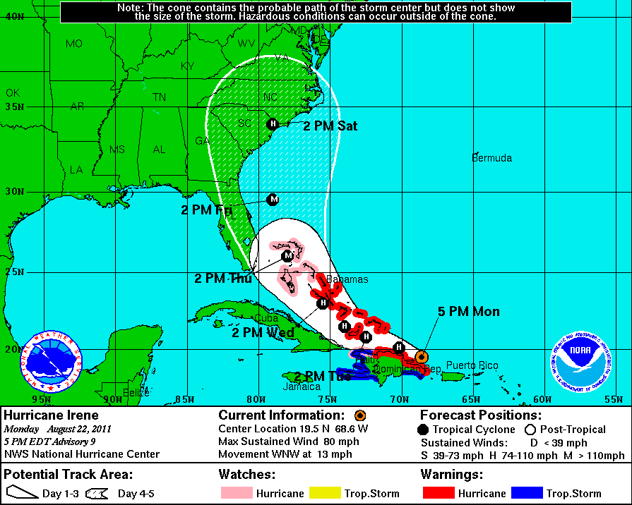
    ...IRENE STRENGTHENS OVER PUERTO RICO...BECOMING THE FIRST HURRICANE OF THE 2011 ATLANTIC SEASON...

    So much for land interaction weakening her. She has actually become a hurricane while still over Puerto Rico.

    Upgraded intensity from the NHC, but some models are showing it a lot stronger at landfall.

    at201109_5day.gif


  • Registered Users Posts: 1,315 ✭✭✭snowstreams


    Looks like its eyeing up Savannah Georgia. They havent had a hurricane in a long time. Could do alot of damage anywhere along Georgia or the Carolinas though if its as low as 924! :eek:


  • Registered Users Posts: 11,134 ✭✭✭✭maquiladora


    From the official forcast :
    SIGNIFICANT STRENGTHENING COULD OCCUR. HOWEVER...THE OFFICIAL INTENSITY WILL REMAIN ON THE CONSERVATIVE SIDE DUE TO THE UNCERTAINTY IN HOW MUCH IRENE WILL INTERACT WITH THE MOUNTAINOUS TERRAIN OF HISPANIOLA FOR THE NEXT 24-36 HOURS. THE OFFICIAL INTENSITY FORECAST IS A BLEND OF
    THE SHIPS/LGEM MODELS AND THE HWRF/GFDL MODELS. HOWEVER...GIVEN THE
    IMPRESSIVE UPPER-LEVEL FLOW PATTERN EXPECTED ACROSS IRENE...IT
    WOULD NOT SURPRISE ME IF THIS CYCLONE BECAME A MAJOR HURRICANE AT
    SOME TIME DURING ITS LIFETIME LIKE THE GFDL AND HWRF MODELS ARE
    FORECASTING.

    She was dangerous for Puerto Rico even at this early stage :

    PRELIMINARY REPORTS INDICATE THAT WIDESPREAD TREE AND POWERLINE
    DAMAGE HAS OCCURRED ON PUERTO RICO...AND MORE THAN 800 THOUSAND
    HOMES ARE WITHOUT POWER ON THE ISLAND.

    ALSO...FAA DOPPLER WEATHER RADAR INDICATES WINDS TO NEAR MAJOR
    HURRICANE STRENGTH ARE NOW OCCURRING IN THE HIGHER ELEVATIONS OF
    THE INTERIOR MOUNTAINOUS REGIONS OF PUERTO RICO.

    $$
    FORECASTER STEWART
    Update Statement From NHC


  • Registered Users Posts: 11,134 ✭✭✭✭maquiladora


    NHC now forecasting Irene to deepen to a major hurricane, Cat 3, over Bahamas on Thursday with a Cat 3 landfall in S Carolina on Saturday.

    at201109_5day.gif


  • Registered Users Posts: 11,134 ✭✭✭✭maquiladora


    Models are all over the place. Some models have shifted east, some have shifted west.

    The latest model out is the GFDL and its horrific.

    Borderline Cat 5 landfall south Florida. Unbelievable.

    12zgfdl2500mbhghtpmsl09.gif

    Floridians will be thankful this is the only model currently showing anything like this.


  • Registered Users Posts: 10,508 ✭✭✭✭dsmythy


    hurrire.gif


  • Closed Accounts Posts: 5,234 ✭✭✭thetonynator


    Still some hope it could veer away and miss Florida and georgia as a major hurricane. . . wishful thinking maybe?!


  • Registered Users Posts: 12 damiansynnott


  • Advertisement
  • Registered Users Posts: 11,134 ✭✭✭✭maquiladora


    Latest HWRF run has shifted closer to Florida.

    Cat 5 just off the east Florida coast, would be serious storm surge and hurricane force winds all up along the Florida coast there, and then a major landfall into Georgia. Not a good run....

    18zhwrf500mbhghtpmslnes.gif


  • Registered Users Posts: 11,134 ✭✭✭✭maquiladora


    Still some hope it could veer away and miss Florida and georgia as a major hurricane. . . wishful thinking maybe?!

    There is very much a chance she could still recurve without making landfall in the US, some models showed that today.

    The latest models have been showing a slight shift to the west though. Will have to wait for tomorrows models I think.


  • Registered Users Posts: 2,674 ✭✭✭Rougies


    Latest HWRF run has shifted closer to Florida.

    Cat 5 just off the east Florida coast, would be serious storm surge and hurricane force winds all up along the Florida coast there, and then a major landfall into Georgia. Not a good run....

    And that's from a model that supposedly usually has a east biased track. Along with the slight westwards shift from other models, Irene is starting to look like a very dangerous hurricane. GFDL should be interesting.


  • Registered Users Posts: 11,134 ✭✭✭✭maquiladora


    The GFDL destroys south Florida, then by this stage the core of the storm is halfway up the middle of the peninsula and its still a major hurricane. You can't even see Florida under Irene here.

    18zgfdl2500mbhghtpmsl10.gif

    I really don't think were going to see an outcome like these. So extreme.

    Meanwhile, right now :
    ...IRENE NOW A CATEGORY TWO HURRICANE...


  • Registered Users Posts: 1,204 ✭✭✭eskimocat


    Certainly one to watch! Thanks for the updates folks! Keep them comin!


  • Registered Users Posts: 11,134 ✭✭✭✭maquiladora


    NHC has upgraded intensity, expected to reach Cat 4 status on Thursday.

    Models are trending to the east so Florida may be in the clear.

    Starting to look more like an east coast or even north east coast storm now. However if the models keep trending east Irene could end up missing the US east coast and recurving out to sea.


  • Registered Users Posts: 1,740 ✭✭✭Faolchu


    I'm flying out to Tampa on Thursday morning :(


    Bay News 9 just posted the following on Twitter:

    Hurricane Irene is near the Dominican Republic this morning. Winds 100
    mph. Moving WNW at 12 mph. Could become a major hurricane by tonight.


    Latest advisory from the NHC is here
    000
    WTNT34 KNHC 230832
    TCPAT4

    BULLETIN
    HURRICANE IRENE ADVISORY NUMBER 12
    NWS NATIONAL HURRICANE CENTER MIAMI FL AL092011
    500 AM EDT TUE AUG 23 2011

    ...IRENE LASHING THE NORTHERN COAST OF THE DOMINICAN REPUBLIC...
    EXPECTED TO MOVE OVER THE TURKS AND CAICOS LATER TODAY...


    SUMMARY OF 500 AM EDT...0900 UTC...INFORMATION
    LOCATION...20.3N 70.1W
    ABOUT 105 MI...170 KM SE OF GRAND TURK ISLAND
    ABOUT 50 MI...85 KM NE OF PUERTO PLATA DOMINICAN REPUBLIC
    MAXIMUM SUSTAINED WINDS...100 MPH...160 KM/H
    PRESENT MOVEMENT...WNW OR 295 DEGREES AT 12 MPH...19 KM/H
    MINIMUM CENTRAL PRESSURE...978 MB...28.88 INCHES


    WATCHES AND WARNINGS
    CHANGES IN WATCHES AND WARNINGS WITH THIS ADVISORY...

    NONE.

    SUMMARY OF WATCHES AND WARNINGS IN EFFECT...

    A HURRICANE WARNING IS IN EFFECT FOR...
    * NORTH COAST OF THE DOMINICAN REPUBLIC FROM THE HAITI BORDER
    EASTWARD TO CABO ENGANO
    * TURKS AND CAICOS ISLANDS...SOUTHEASTERN AND CENTRAL BAHAMAS

    A HURRICANE WATCH IS IN EFFECT FOR...
    * NORTH COAST OF HAITI FROM LE MOLE ST. NICHOLAS EASTWARD TO THE
    DOMINICAN REPUBLIC BORDER
    * NORTHWESTERN BAHAMAS

    A TROPICAL STORM WARNING IS IN EFFECT FOR...
    * SOUTH COAST OF THE DOMINICAN REPUBLIC FROM SANTO DOMINGO EASTWARD
    TO CABO ENGANO
    * ALL OF HAITI

    FOR STORM INFORMATION SPECIFIC TO YOUR AREA...PLEASE MONITOR
    PRODUCTS ISSUED BY YOUR NATIONAL METEOROLOGICAL SERVICE.


    DISCUSSION AND 48-HOUR OUTLOOK
    AT 500 AM AST...0900 UTC...THE CENTER OF HURRICANE IRENE WAS LOCATED
    NEAR LATITUDE 20.3 NORTH...LONGITUDE 70.1 WEST. IRENE IS MOVING
    TOWARD THE WEST-NORTHWEST NEAR 12 MPH...19 KM/H. THIS GENERAL MOTION
    IS EXPECTED TO CONTINUE THROUGH TODAY...FOLLOWED BY A TURN TOWARD
    THE NORTHWEST TUESDAY NIGHT AND WEDNESDAY. ON THE FORECAST TRACK...
    THE CORE OF IRENE WILL PASS TO THE NORTH OF THE DOMINICAN REPUBLIC
    AND HAITI THIS MORNING...NEAR OR OVER THE TURKS AND CAICOS ISLANDS
    AND THE SOUTHEASTERN BAHAMAS BY TONIGHT...AND BE NEAR THE CENTRAL
    BAHAMAS EARLY WEDNESDAY.

    MAXIMUM SUSTAINED WINDS REMAIN NEAR 100 MPH...160 KM/H...WITH HIGHER
    GUSTS. IRENE IS A CATEGORY TWO HURRICANE ON THE SAFFIR-SIMPSON
    HURRICANE WIND SCALE. ADDITIONAL STRENGTHENING IS FORECAST DURING
    THE NEXT 48 HOURS...AND IRENE COULD BECOME A MAJOR HURRICANE LATER
    TODAY OR ON WEDNESDAY.

    HURRICANE-FORCE WINDS EXTEND OUTWARD UP TO 50 MILES...85 KM...FROM
    THE CENTER...AND TROPICAL-STORM-FORCE WINDS EXTEND OUTWARD UP TO 205
    MILES...335 KM. EARLIER THIS MORNING...A SUSTAINED WIND OF 58 MPH...
    93 KM/H WAS REPORTED AT PUERTO PLATA DOMINICAN REPUBLIC.

    ESTIMATED MINIMUM CENTRAL PRESSURE IS 978 MB...28.88 INCHES.


    HAZARDS AFFECTING LAND
    WIND...TROPICAL STORM CONDITIONS WILL CONTINUE TO SPREAD OVER THE
    NORTHERN PORTIONS OF DOMINICAN REPUBLIC THIS MORNING AND INTO THE
    AFTERNOON...AND LOCALIZED HURRICANE CONDITIONS ARE EXPECTED OVER
    THE NORTHERN PORTIONS OF THE DOMINICAN REPUBLIC THIS MORNING. THE
    HIGHEST WINDS ARE LIKELY TO OCCUR OVER AREAS OF ELEVATED TERRAIN.
    TROPICAL STORM CONDITIONS ARE EXPECTED TO REACH THE SOUTHEASTERN
    BAHAMAS AND THE TURKS AND CAICOS ISLANDS LATER THIS MORNING WITH
    HURRICANE CONDITIONS EXPECTED BY THIS AFTERNOON AND EVENING.
    TROPICAL STORM CONDITIONS ARE FORECAST TO REACH THE CENTRAL BAHAMAS
    LATE TONIGHT WITH HURRICANE CONDITIONS EXPECTED BY WEDNESDAY.
    TROPICAL STORM CONDITIONS ARE POSSIBLE IN THE NORTHWESTERN BAHAMAS
    BY LATE WEDNESDAY...WITH HURRICANE CONDITIONS POSSIBLE BY THURSDAY.

    RAINFALL...IRENE IS EXPECTED TO PRODUCE ADDITIONAL RAINFALL
    ACCUMULATIONS OF 2 TO 4 INCHES ACROSS PUERTO RICO. RAINFALL
    AMOUNTS OF 3 TO 6 INCHES ARE EXPECTED OVER NORTHERN HISPANIOLA...
    WITH ISOLATED MAXIMUM AMOUNTS OF UP TO 10 INCHES POSSIBLE OVER
    HIGHER TERRAIN. THESE RAINS COULD CAUSE LIFE-THREATENING FLASH
    FLOODS AND MUDSLIDES IN AREAS OF STEEP TERRAIN. RAINFALL
    ACCUMULATIONS OF 5 TO 10 INCHES ARE EXPECTED IN THE SOUTHEASTERN
    AND CENTRAL BAHAMAS...AND THE TURKS AND CAICOS ISLANDS.

    STORM SURGE...A STORM SURGE WILL RAISE WATER LEVELS BY AS MUCH AS
    9 TO 13 FEET ABOVE NORMAL TIDE LEVELS OVER THE SOUTHEASTERN AND
    CENTRAL BAHAMAS...AND THE TURKS AND CAICOS ISLANDS. STORM SURGE
    WILL ALSO RAISE WATER LEVELS BY AS MUCH AS 2 TO 4 FEET ABOVE NORMAL
    TIDE LEVELS ALONG THE ENTIRE COAST OF THE DOMINICAN REPUBLIC. NEAR
    THE COAST...THE SURGE WILL BE ACCOMPANIED BY LARGE AND DANGEROUS
    WAVES.


    NEXT ADVISORY
    NEXT INTERMEDIATE ADVISORY...800 AM EDT.
    NEXT COMPLETE ADVISORY...1100 AM EDT.

    $$
    FORECASTER STEWART


  • Registered Users Posts: 11,134 ✭✭✭✭maquiladora


    Faolchu wrote: »
    I'm flying out to Tampa on Thursday morning :(

    The good news for you is that its looking more and more likely that she will miss Florida. Tampa is outside the cone now and the trend with the models is eastward.

    Could all change again but at the moment its looking like either an east coast landfall or the classic recurve out to sea.


  • Registered Users Posts: 1,740 ✭✭✭Faolchu


    The good news for you is that its looking more and more likely that she will miss Florida. Tampa is outside the cone now and the trend with the models is eastward.

    .


    yeah but we also planned on doing a few days in Orlando which at the minute may still be in the path and our light is due to land in Orlando (MCO). I've been glued to the twitter fot NHC atlantic all through the night.

    fingeres crossed she heads back out to sea


  • Advertisement
  • Registered Users Posts: 320 ✭✭tomcosgrave


    NHC just posted Advisory 12A, here's the essentials -

    SUMMARY OF 800 AM EDT...1200 UTC...INFORMATION
    LOCATION...20.6N 70.6W
    ABOUT 70 MI...110 KM SSE OF GRAND TURK ISLAND
    ABOUT 55 MI...90 KM N OF PUERTO PLATA DOMINICAN REPUBLIC
    MAXIMUM SUSTAINED WINDS...100 MPH...160 KM/H
    PRESENT MOVEMENT...WNW OR 295 DEGREES AT 10 MPH...17 KM/H
    MINIMUM CENTRAL PRESSURE...978 MB...28.88 INCHES

    DISCUSSION AND 48-HOUR OUTLOOK
    AT 800 AM EDT...1200 UTC...THE CENTER OF HURRICANE IRENE WAS LOCATED
    NEAR LATITUDE 20.6 NORTH...LONGITUDE 70.6 WEST. IRENE IS MOVING
    TOWARD THE WEST-NORTHWEST NEAR 10 MPH...17 KM/H. THIS GENERAL
    MOTION IS EXPECTED TO CONTINUE THROUGH TONIGHT...FOLLOWED BY A TURN
    TOWARD THE NORTHWEST ON WEDNESDAY. ON THE FORECAST TRACK...THE
    CORE OF IRENE WILL PASS TO THE NORTH OF THE DOMINICAN REPUBLIC AND
    HAITI THIS MORNING...NEAR OR OVER THE TURKS AND CAICOS ISLANDS AND
    THE SOUTHEASTERN BAHAMAS TONIGHT...AND BE NEAR THE CENTRAL BAHAMAS
    EARLY WEDNESDAY.

    MAXIMUM SUSTAINED WINDS ARE NEAR 100 MPH...160 KM/H...WITH HIGHER
    GUSTS. IRENE IS A CATEGORY TWO HURRICANE ON THE SAFFIR-SIMPSON
    HURRICANE WIND SCALE. ADDITIONAL STRENGTHENING IS FORECAST DURING
    THE NEXT 48 HOURS...AND IRENE COULD BECOME A MAJOR HURRICANE LATER
    TODAY OR ON WEDNESDAY.

    HURRICANE-FORCE WINDS EXTEND OUTWARD UP TO 50 MILES...85 KM...FROM
    THE CENTER...AND TROPICAL-STORM-FORCE WINDS EXTEND OUTWARD UP TO 205
    MILES...335 KM.

    ESTIMATED MINIMUM CENTRAL PRESSURE IS 978 MB...28.88 INCHES.


Advertisement