Advertisement
If you have a new account but are having problems posting or verifying your account, please email us on hello@boards.ie for help. Thanks :)
Hello all! Please ensure that you are posting a new thread or question in the appropriate forum. The Feedback forum is overwhelmed with questions that are having to be moved elsewhere. If you need help to verify your account contact hello@boards.ie
Hi all! We have been experiencing an issue on site where threads have been missing the latest postings. The platform host Vanilla are working on this issue. A workaround that has been used by some is to navigate back from 1 to 10+ pages to re-sync the thread and this will then show the latest posts. Thanks, Mike.
Hi there,
There is an issue with role permissions that is being worked on at the moment.
If you are having trouble with access or permissions on regional forums please post here to get access: https://www.boards.ie/discussion/2058365403/you-do-not-have-permission-for-that#latest
There is an issue with role permissions that is being worked on at the moment.
If you are having trouble with access or permissions on regional forums please post here to get access: https://www.boards.ie/discussion/2058365403/you-do-not-have-permission-for-that#latest
Archaeoastronomy at megalithic sites
Comments
-
Join Date:Posts: 4959
Stunning photo.0 -
Ring-ditch KD023-038 (below) sits atop a prominent knoll on the plains of the Curragh, and lies less than 3 kilometres NE of Kildare town. This ring-ditch has a west-facing causewayed entrance which may be aligned to a place on the horizon where the sun sets at or close to the equinoxes.

I had a notion that it may also be possible to observe the sun setting at the site of St.Brigid's cathedral and round tower on the November and February cross-quarter days from this very same ring-ditch. Yesterday was the November cross-quarter day (7th. November - a day that escaped the attention of the vast majority of humanity no doubt), and what you're seeing in the series of images below is the sun setting at the site of St.Brigid's cathedral; this also means that come the next February cross-quarter day (4th. February, 2016) the sun will set in very much the same place. For those wondering what the significance of the site of St.Brigid's is, I'd recommend reading post #139 in this thread. By the way, the black dots in the amber sky are Rooks returning to their evening roost in the Curragh.


Could it be that those who constructed these ancient monuments chose the site of the monuments because it was possible to observe the sun rising and setting from/at prominent positions on the horizon, on not just one or two significant days of the year but several, i.e. at the solstices, equinoxes and cross-quarter days? My investigation of monuments in close proximity to KD023-038 (within one square kilometre) would suggest that that's a distinct possibility (see post #139 in this thread; Plate 2). My next mission is to hopefully observe the Winter solstice sun rising from the summit of Slievemaan from this same ring-ditch. I'm also very confident that from KD023-038 I will see the Summer solstice sun set between the hills of Dunmurry and Grange to the NW, at a spot known as Carrickanearla ('cathaoir/carraig an Íarla', 'the chair/rock of the Earl) that was believed to be the royal inauguration site of the kings of the Uí Failghe.
The image below was taken on Friday evening (6th. Nov.) from the centre of ring-barrow KD022-046, which appears to have its causewayed entrance aligned to the horizon where the sun sets at the November and February cross-quarter days. On the following day the sun would set 0.5° further south (one full sun width), so it looks like the alignment is very close. I also discovered that it's possible to see the Winter solstice sun setting at the site of St.Brigid's cathedral from this ring-barrow too (it's on the same solstice alignment as KD022-043, a ring-barrow discussed at length in post #139).
Ring-ditch KD023-038 can be seen in the right-hand corner of this Google Earth image, while KD022-046 lies 800 metres to the W-NW: 0
0 -
Join Date:Posts: 4959
You were right to put a watermark on your photos. I would be tempted to steal them.
Here is an outside the box thought. Some of these solar movements appear to be happening on comparatively featureless horizons. If the openings in the monuments are indeed aligned on solar events, what was being used as a 'target' feature?
The large timber post that may have pre-dated the passage tomb at Fourknocks, was quite possibly a monument in itself, perhaps a form of totem pole. Timber post as monuments are only just beginning to be recognised in Mesolithic sites.
Is it possible that the monument builders on these flat plains may have erected timber posts somewhere outside the enclosure as a focus for solar alignments?
Post-hole arrangements in later Neolithic monuments (henges , causewayed enclosures) frequently echo the interior cruciform arrangement of passage tombs and this may have been sufficient architecture to see the alignments. We can only guess what was supported by the posts. There may have been timber light box equivalents in these structures. Timber, of course, would allow easier construction of more complex structures and if such structures existed, they may also have been decorated. They may have been a kind of budget version of earlier, stone built monuments. However, the possibility that there was an imposing post somewhere outside the enclosure, has a certain appeal. Finding evidence would be another matter all together.0 -
slowburner wrote: »You were right to put a watermark on your photos. I would be tempted to steal them.
Here is an outside the box thought. Some of these solar movements appear to be happening on comparatively featureless horizons. If the openings in the monuments are indeed aligned on solar events, what was being used as a 'target' feature?
The large timber post that may have pre-dated the passage tomb at Fourknocks, was quite possibly a monument in itself, perhaps a form of totem pole. Timber post as monuments are only just beginning to be recognised in Mesolithic sites.
Is it possible that the monument builders on these flat plains may have erected timber posts somewhere outside the enclosure as a focus for solar alignments?
Post-hole arrangements in later Neolithic monuments (henges , causewayed enclosures) frequently echo the interior cruciform arrangement of passage tombs and this may have been sufficient architecture to see the alignments. We can only guess what was supported by the posts. There may have been timber light box equivalents in these structures. Timber, of course, would allow easier construction of more complex structures and if such structures existed, they may also have been decorated. They may have been a kind of budget version of earlier, stone built monuments. However, the possibility that there was an imposing post somewhere outside the enclosure, has a certain appeal. Finding evidence would be another matter all together.
My belief, without evidence to back it up, is that wooden posts were sited outside the barrows and ring-ditches on the Curragh to help mark specific days of the year. I created the illustration below many moons ago, which shows how this could work. In reality I think the posts should be to the left of the actual alignments shown (if that makes sense) for it to work effectively.
The possibility that there may even have been timber roofed structures within the barrows did cross my mind on many an occasion too. There's a barrow on the Curragh which appears to have a south-facing entrance, but why? The sun and moon won't ever rise or set due south. One tantalising possibility I've been mulling over is that it may have been constructed to help mark solar noon on the day of the Winter solstice. At solar noon the sun is at its highest in the sky and is also due south. Shadows cast at mid-winter are typically longer than at any other time of year (the sun is at its lowest in the sky at midday on the Winter solstice), so by using posts, one outside the causewayed entrance and another at the centre of the barrow, the shadow cast by the outer post would fall onto the post in the centre where it can then be marked. Another alternative is a wooden structure within the barrow with, as you say, something akin to a timber light box incorporated into it. It's a whacky theory I know, but Martin Brennan suggests in 'The Stones of Time' that the south-facing passage of a satellite mound at Newgrange may have helped marked solar noon on the Winter solstice, so there may have been a precedence? I was going to upload a post setting out this theory, but thought better of it, thinking you guys would consider me mad!:)
P.S. - I recall seeing a Time Team programme many years ago that was filmed at a place called Loch Migdale (or was it Loch Tay?) in Scotland, where the team excavated a henge-like monument and discovered a wooden structure at the centre of the monument. They also found a large recumbent stone just inside the causewayed entrance. A theory proposed was that the wooden posts/structure and the stone were aligned to a v-shaped notch in a mountain on the opposite side of the Loch where the sun was seen to rise/set on a certain day, so using wooden posts/structures within these monuments might not be as far fetched a theory as we think.0 -
Seriously, Bonedigger- much and all as I really, really enjoy your posts here, you should definitely be putting this together as a book. Not only is it a really well thought out theory, but you have even done the diagrams and you have knockout photos to boot!
Great stuff (and keep posting it up until you do decide to publish!!)0 -
Advertisement
-
baaba maal wrote: »Seriously, Bonedigger- much and all as I really, really enjoy your posts here, you should definitely be putting this together as a book. Not only is it a really well thought out theory, but you have even done the diagrams and you have knockout photos to boot!
Great stuff (and keep posting it up until you do decide to publish!!)
Thanks very much baaba - your comments are most kind!
I hope I don't sound too disingenuous but, I'm not sure that the work I've done is worthy of being published to be brutally honest.
It's really just a pet project and something that helps keep my brain ticking over.
Certainly some of my findings look more than curious, but those who've studied and explored the subject of alignments relating to ancient monuments far longer than I have will need more convincing (and certainly more evidence). I'll continue to do the research of course, and have no doubt I'll find more curiosities relating to these ancient monuments on the Curragh. How far can I take it, who knows?
If someone more learned and distinguished than I hits on the same curious alignments (whether they be deliberate or just coincidental) in the future, you can at least tell them you heard it here first!") 0
0 -
Great stuff as always Bonedigger.
I made it to Dr Frank Prendergasts talk about Grange Stone Circle last Wednesday (week) in Limerick and enjoyed it. He seems like a very nice man and as he says he lets the data do the talking. He has made an interactive starlab that shows where the sun, moon and stars rises and sets at any time and date over the last 5,000 years at Grange Stone Circle in Co. Limerick.
He does (jokingly) have an issue with people that look at a site and then try to find the alignment (which would be me and Bonedigger above I suppose!). Again he only argues the data and you can only respect him for that. He showed a slide about the stone rows of south west Ireland and the data shows that they seem to take an interest in the moon at certain times in its cycle (I have a spreadsheet down up with when if anyone is interested). He also mentioned that the henge that was destroyed at Lismullin - that the data shows that it was interested in the rising of the Pleiades when it was constructed.
Regarding Grange Lios he dates it as 2950-2950BC which to him is the Neolithic and I understand that he doesn't think that the cross-quarter days were marked in the Neolithic. So for the Grange Lios the data (excluding the cross-quarter days) doesn't show any alignment. I would agree that the Summer Solstice sunrise alignment does look a bit ropey from direct observation but my personal opinion is that the Nov / Feb cross-quarter sunset alignment does look fairly close and is actually on the axis of the circle. The one alignment he does list as a possibility is winter solstice sunrise over the Galtees but this is over a reasonably prominent stone rather than directly on the axis of the circle.
Anyway as I always say I don't take this too seriously and the worst thing that can happen when going to view an "alignment" is to have a nice walk and see a beautiful sunrise or sunset.0 -
Hello bawn79,
Modern society may tend to think of prehistoric tribes and nations as rough, rude, ignorant folk, hardly capable of lighting a campfire; yet archaeological research has proven that our remote ancestors, from the Palaeolithic to the Neolithic, were keenly observant of their surroundings, of nature in general and of the heavens in particular. Ancient peoples studied the sky long before the invention of the telescope. They were fascinated by the sinuous forms of the constellations, which they reproduced with great accuracy in the form of sculpted cup-marks (a phenomenon that occurs all over the world). They observed eclipses and depicted these, too, in their rock engravings. Most surprisingly of all, according to research that I am conducting on archaeoastronomy and archaeophysics, certain ancient peoples already knew of the existence of (at least!) nine planets in our solar system, as well as the shape of the atom and the Big Bang theory...Amazing? Yes; but Man's curiousity and capacity for scientific investigation are truly amazing, in all times, at all stages of his development. Prehistory was an epoch of intense research and experimentation, not pitiful ignorance.0 -
Join Date:Posts: 4959
-
Hello slowburner,
No member of this forum has proposed that unfavourable opinion, as far as I know. To the contrary: it's refreshing to see openmindedness, imagination and the love of scientific exploration here. In mentioning that negative concept of our forefathers, I was simply rejecting a lamentably common general opinion, very widespread among the public, which would deny to our prehistoric ancestors all sophistication and intellectual prowess. I posted my rather unorthodox ideas here because I knew that they would be listened to and considered.0 -
Advertisement
-
Join Date:Posts: 4959
OK. Confusion can arise if a post begins by addressing a named forum member and the subject matter is unrelated to the adressee. It might be worth bearing that in mind for future posts, unorthodox or otherwise.Hello slowburner,
No member of this forum has proposed that unfavourable opinion, as far as I know. To the contrary: it's refreshing to see openmindedness, imagination and the love of scientific exploration here. In mentioning that negative concept of our forefathers, I was simply rejecting a lamentably common general opinion, very widespread among the public, which would deny to our prehistoric ancestors all sophistication and intellectual prowess. I posted my rather unorthodox ideas here because I knew that they would be listened to and considered.0 -
Sorry, no harm was intended! I'm new to this forum. The last thing in the world I would have wanted was to offend anyone.:(0
-
I reported here last year that I may have found an unrecorded monument on the Curragh via OSi aerial images. It was discovered by chance when I was working on a possible summer solstice sunset alignment in relation to another prehistoric monument. This circular feature fell along the same alignment which effectively means the sun would set at the same point on the horizon from both places.
The OSi Ortho images below show the circular feature I discovered. The shape and outline of the circular feature does not appear to change in any way over the ten years from 1995 to 2005.

The circular feature as it appears on the ground:
Taken just several metres outside and east of the circular feature, the image below shows the summer solstice sun approaching the summit of Dunmurry hill which sits on the horizon to the Northwest. Note the red arrow marking a large notch at the summit of the hill:
My suspicion was that I would see the summer solstice sun disappear into that notch on the summit of Dunmurry as I watched on from the centre of the circular feature, and that is in fact what happened:


So what does it all mean? Maybe the circular feature was a ring-ditch/ring-barrow and was deliberately constructed at that spot to help its prehistoric builders mark the solstice period? The notch in the summit of Dunmurry hill would mark the most northerly position of the sun on the horizon that year as observed from this ring-ditch/ring-barrow.
I believe this feature is a previously unrecorded ring-ditch or ring-barrow because it conforms in both size and shape to similar monuments in close proximity. Ring-barrow KD022-046 lies 260 metres S-SW of this circular feature, and is similar in size.
I sent a report form to the National Monuments Service recently, so it should be interesting to see what they make of this feature.0 -
Join Date:Posts: 4959
I have little if any doubt that you have identified a barrow. Well done!
However, it might be prudent to hold off on assumptions about solar (or lunar) alignments.
Why?
Because generally such alignments are associated with passage tombs, henges, or stone circles. They are not generally associated with barrows. This does not preclude the possibility. Far from it. But until we know what was within the enclosure, we cannot say what aligned with what. I think we may have discussed this previously: the possibility that timber structures may have formed some sort of a light box, or something similar. It is more of a thought exercise than anything based in proven archaeology.
Until that is...proven otherwise.0 -
@Hotei, Absolutely fascinating, and while I understand slowburner's reservations I think the probability that the 'barrow' location was specifically chosen for it's solstice alignment is quite likely. Of course there would be quite a wide and long arc where the same alignment would be visible, and if you suspect a solar alignment it might be worth delving a little further and looking at the rising sun and the winter solstice alignments from the same location.
A number of years back I had spent some time trying to find points of intersection between a 'summer solstice arc' from one particular prominent hill and a 'winter solstice arc' from another hill that might reveal archaelogical sites with stone circles, standing stones etc.. A work in progress.0 -
Join Date:Posts: 4959
Here is an interesting theory...
http://gizmodo.com/did-prehistoric-people-watch-the-stars-through-this-6-0-17827597910 -
slowburner wrote: »Here is an interesting theory...
http://gizmodo.com/did-prehistoric-people-watch-the-stars-through-this-6-0-1782759791
Will have to try this out. Tried to observe a moonrise inside a passage tomb with a long passage before but a passage works like a camera lens, the longer and narrower it is the less light from all sources reaches the chamber. I think it would actually be harder to spot a single star down a passage, all else being equal.0 -
Boheh Stone/ St Patrick's Chair, Co. Mayo.
https://voxhiberionacum.wordpress.com/2013/04/18/pre-christian-rock-and-roll/
A good read.0 -
Kilmogue Portal Tomb (near Mullinavat, Co Kilkenny) faces NE, towards the rising sun at the summer solstice. It's also called Leac an Scail which is given as "the hero's stone", but couldn't it be "the sunburst stone"? It also faced Brandon Hill (567 m). Has anyone visited the site?
https://en.wikipedia.org/wiki/Kilmogue_Portal_Tomb0 -
In late November, I visited the prehistoric standing stone at Punchestown in Co.Kildare. Despite being from Kildare myself, it was the first time I set eyes on it. The monolith has been dubbed the 'Punchestown longstone', and is Ireland's tallest prehistoric standing stone (7.1 m tall). It fell in the year 1931, and when it was re-erected in 1934, a small cist was discovered at its base. The cist was found to be empty. The longstone at the centre of the henge at Forenaughts Great four kilometres northeast of Punchestown also had a cist associated with it, and along with cremated human remains, pottery, and a flint blade, a wrist-guard was also found in the cist which is a typical Beaker find. It's conceivable the Punchestown longstone and cist date to the same period, that is the EBA c. 2500 - 1800 B.C.E.
*All the images and illustrations below are my creations, except the Google Earth and Photographer's Ephemeris imagery of course.
Punchestown longstone
The presence of the cist at its base would lead one to believe that the standing stone was nothing more than a grave marker (and it's hard to argue against that), but something in my gut was telling me there may have been something else going on here. I subsequently discovered a winter solstice sunset alignment (with help from the Photographer's Ephemeris) between Punchestown longstone and Knockaulin, the ancient royal ceremonial site of Dún Ailinne. The illustration below shows the alignment from the longstone to Knockaulin with some rather curious features falling along the same alignment in between:
I had to investigate the alignment on the ground, so I visited Punchestown once again to see if Knockaulin is visible from the site of the longstone. Although the view southwest is obscured by trees today, beyond the trees is the not so insignificant hill of Mullacash. The summit of Mullacash is at a higher elevation than the longstone at Punchestown, so it was never possible to see Knockaulin from there.
This image of the Punchestown longstone was taken several days before the official winter solstice, and shows the setting sun shortly before it disappeared behind the hill of Mullacash (now obscured by the trees several hundred metres away):
Below is an image I took of the setting sun descending behind Mullacash hill on the 19th of December (standing along the alignment just downhill of the longstone). The sun set at an azimuth of 230° that evening, a mere 0.1° north of where it would 2 days later on the solstice (229.9°). What this invariably means is what you're seeing in the image below is more or less what one would see at sunset on the winter solstice. If our prehistoric ancestors were standing at the longstone just before sundown on the winter solstice, would they have seen the same thing? We must first take into account the angle of the Earth's axial tilt (obliquity of the ecliptic) which in the Late Neolithic/EBA was ~24°, but today is closer to ~23.4°. This in effect means that at winter solstice in the Neolithic/EBA the sun would have risen and set 1° further south than it does today; this 1° is equivalent to roughly two solar diameters. I believe (on rough calculation) that the full sun would have appeared to sit just above the summit of the hill briefly before setting just to the right of it.
Mullacash hill sunset two days prior to the winter solstice:
A noteworthy feature along the alignment between the longstone and Mullacash hill is a ring-barrow (KD024-008) situated 1 kilometre downslope in the townland of Swordlestown North. The alignment passes directly through the centre of the barrow. Investigations by archaeologist Seán P. Ó Ríordáin (Ó Ríordáin 1950, 273) suggested an Early Iron Age date for this barrow (and several others in its vicinity) given its similarities to barrows excavated on Carbery hill to the northwest. The ring-barrow is smothered in scrub today, and trees surrounding it make it difficult to see Mullacash, but it's feasible the winter solstice sunset was observed from here too. One tantalising possibility is that this barrow may have been a focal point for the observation of both the winter solstice sunset and the summer solstice sunrise. Although a kilometre uphill from the ring-barrow, the longstone's profile may have been visible above the horizon (hedgerows and trees along the road verges block any view now) marking where the sun would rise on the morning of the summer solstice. This will need further investigation next summer.
Swordlestown North Ring-barrow:
Summer solstice sunrise alignment from Swordlestown North ring-barrow to Punchestown longstone:
Mullacash hill is 4 kilometres southwest of the Punchestown longstone, so I took a trip up there to see if it was possible to view Knockaulin hill from there. The solstice sunset alignment passes over the hill some 250 metres north of the summit, so I needed to be somewhere close to the alignment lower down its slope. I first sought permission from a local farmer to walk onto his land where the alignment passed through. Using a handheld GPS device, I found a spot along the alignment where I hoped it would be possible to see Knockaulin, but unfortunately the view SW was obscured by trees. Moving 80 metres south of the alignment (and closer to the summit), I saw the unmistakable profile of Knockaulin on the far horizon - bingo! I took the images below 6 days before the solstice. On this evening the sun would set at an azimuth of 230.2°, 0.3° further north than it would at the solstice - this would amount to about 3/5 of a solar diameter in the difference. Taking this into account, and the Earth's axial tilt in the Late Neolithic/EBA, by my reckoning the sun's upper limb would be seen to disappear at the summit or very close to it at the winter solstice in prehistory. Excavations carried out on Knockaulin in the 1970s revealed evidence of Neolithic and Bronze Age burial activities. Linkardstown-type pottery was recovered suggesting there may have been a burial mound at the summit, but we know that ritual activities reached a peak in the Iron Age when postholes of massive circular wooden structures were uncovered during excavation.
Mullacash hill:
Sunset on Knockaulin on the evening of the 15th December:
The sun's upper limb about to disappear north of the summit:
Before leaving Mullacash, I think it's worth mentioning that while looking at satellite imagery of the hill, I spotted some curious circular cropmarks in tillage not far from the summit. One of the cropmarks falls directly on the alignment. They could be just the underlying geology, but I think they're archaeological features, and perhaps ring-ditches or ring-barrows (the largest being approximately 50m. in diameter). They don't appear on any OSI historical maps, nor are they recorded on the NMS Historic Environment Viewer.
The circular cropmarks on Mullacash which may be unrecorded archaeological features:
The very last place to investigate along the alignment was an enclosure 600 metres from the summit of Knockaulin. This feature (KD028-036) was discovered on Cambridge University aerial photography in the 1960s, and it is believed to be a ring-ditch or barrow.
Rather than trespass on land and take the shot from the site of the ring-ditch/barrow, I took the image below from the road some 300 metres further back on the same alignment.
Winter solstice sunset on Knockaulin (3:26 p.m., 21 December, 2016):
Is the Punchestown longstone to Knockaulin winter solstice sunset alignment just a random orientation?0 -
Advertisement
-
dublinviking wrote: »how about this:
The Rolling Sun of Boheh
http://www.carrowkeel.com/sites/croaghpatrick/gifs/RollingSun.gif
Just wondering, is this idea of the setting sun following the contours of a hill known to have been "a thing" for prehistoric people in Ireland? Would it be connected with Mediterranean type legends of a sun god riding across the sky in his sun chariot?
the full sun would have appeared to sit just above the summit of the hill briefly before setting just to the right of it.
Mullacash hill sunset two days prior to the winter solstice:
There is a sloping hill near where I live and the sun appears to follow its contour, more or less, in midsummer, staying just above the contour of the hill. I would usually see it from a spot where there is a barely perceptible circular mound of about 4 metres diameter in the grass, but the same view would be visible from a wider area.
The coincidence is that the angle of the hill matches the angle of the suns descent, in midsummer, which is handy for a barbeque because you stay in the sun for as long as possible. I suppose its a nice feature to look at too.
I wonder would the "rolling sun" effect have had a deeply spiritual meaning for prehistoric people, or would it just have been a sideshow at good spot for an ancient (or modern) summer barbeque/drinking festival?0 -
Join Date:Posts: 4959
Just wondering, is this idea of the setting sun following the contours of a hill known to have been "a thing" for prehistoric people in Ireland? Would it be connected with Mediterranean type legends of a sun god riding across the sky in his sun chariot?
There is a sloping hill near where I live and the sun appears to follow its contour, more or less, in midsummer, staying just above the contour of the hill. I would usually see it from a spot where there is a barely perceptible circular mound of about 4 metres diameter in the grass, but the same view would be visible from a wider area.
The coincidence is that the angle of the hill matches the angle of the suns descent, in midsummer, which is handy for a barbeque because you stay in the sun for as long as possible. I suppose its a nice feature to look at too.
I wonder would the "rolling sun" effect have had a deeply spiritual meaning for prehistoric people, or would it just have been a sideshow at good spot for an ancient (or modern) summer barbeque/drinking festival?
Good question :pac:
0 -
This evening's Spring Equinox sunset observed from the west-facing causewayed entrance of a ring-barrow on the Curragh:

Red hills (which has a trivallate ring-barrow at its summit) rises to the right, but the sun is setting at a place lower down the slope known as Knocknagalliagh, probably derived from the Irish 'Cnoc na gCailleach'. Logainm.ie suggests an association with nuns ie., 'the hill of the nuns', but I've wondered whether the hill had a much earlier association with the Cailleach, the divine hag and a creator deity. Intriguingly enough, there's also a Knocknagalliagh in Co. Antrim which is known locally as 'the Hag's hill'. A 'tumulus'/cairn sits atop this hill with other prehistoric monuments in close proximity. Loughcrew or Sliabh na Calliagh, Co.Meath is most famously associated with this Hag Goddess. The passage and chamber of Cairn T is illuminated by the rising sun for a period of time around the equinoxes. 0
0 -
My last post here (#174) showed the Spring Equinox sunset from the west-facing entrance of a ring-barrow on the Curragh. The sun set behind a hill known as Knocknagalliagh (Cnoc na gCailleach). I was curious if there were any other archaeological features falling along this Equinox alignment beyond Knocknagalliagh. I didn't have to look far! Just over the hill, on its lower slopes I spotted a circular crop mark in a field. I checked the SMR database and the Historic Environment Viewer, but there was no record of any archaeological feature at that particular site. It needed further investigation, so I paid a visit in September of 2017.


Anyway, to cut a long story short, this circular feature has since been recorded on the SMR database, and is classified as an Enclosure (KD022-122----). The record can be viewed on the Historic Environment Viewer here:
http://webgis.archaeology.ie/historicenvironment/
When at the site in September last, I noticed a curious looking hill on the northwest horizon through some very large trees. I knew this hill very well having visited it several times over the years. It was Croghan hill in Co. Offaly:
https://en.wikipedia.org/wiki/Croghan_Hill
Its position on the northwest horizon got me very excited indeed! There was a distinct possibility that the setting sun at summer solstice would descend behind Croghan hill itself when watching on from this enclosure. Well, on the evening of the 18th. June (Monday), I witnessed the following:


The sun (on the 18th. June) is setting on the local horizon at an azimuth of 313°, and on the solstice (21st. June) it will set at an azimuth of 313.1°. This 0.1° difference is miniscule and invariably means what you're seeing in the above images is what one would see on the actual solstice. Due to the shift in the earth's axial tilt over the millennia, it's most likely the sun would have set at least one solar disc in diameter further north (over to the right of the summit) in prehistory than it does today. I think this would have looked even more impressive!
I read recently that when on the Hill of Uisneach on the morning of the Winter solstice, the sun will rise up from behind Croghan hill. Uisneach we know was an extremely important sacred site in prehistory, but was this newly discovered enclosure a place of great sacredness too?!!0 -
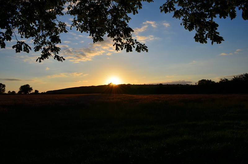
A shot taken from the Curragh of Kildare this evening showing the summer solstice sun descending behind the hill of Dunmurry:


I hope to upload a post in the coming days to outline the significance (or not!) of this particular sunset.0 -
Join Date:Posts: 4959
A shot taken from the Curragh of Kildare this evening showing the summer solstice sun descending behind the hill of Dunmurry:
I hope to upload a post in the coming days to outline the significance (or not!) of this particular sunset.
It would be good to see a ‘human eye’ view of these scenes.
How would the setting sun have been observed in this landscape - without magnification?0 -
slowburner wrote: »It would be good to see a ‘human eye’ view of these scenes.
How would the setting sun have been observed in this landscape - without magnification?
I think this image would give you a better understanding of what it would be like observing at a distance. This was taken about twenty-five minutes before sunset.
I'll do my best to post within the next couple of days to give a bit more context to what you're seeing. 0
0 -
In a follow-on from post #176 above, I hope to outline the significance of the sunset I captured on the evening of the summer solstice when I witnessed the sun descend behind Dunmurry hill from the Curragh plains in Co. Kildare.
Ring-barrow KD028-074 is situated on the southeastern extremities of the Curragh plains. I discovered several years ago that it is possible to observe the setting sun descend behind the summit of Redhill (situated 10 kilometres away on the W-NW horizon) on the May and August cross-quarter days - these days would have coincided with the ancient festivals of Bealtaine and Lughnasadh.
A view of ring-barrow KD028-074 with the Wicklow mountains visible due east on the far horizon (note the position of the knoll in the background):
The May cross-quarter day sunset of 2017 on Redhill observed from the centre of KD028-074:
The August cross-quarter day sunset of 2015 on Redhill as observed from KD028-074:
On one of my first visits to KD028-074, I noticed Dunmurry hill on the northwest horizon (it has a telecommunications mast at its summit). The position of this hill on the NW horizon suggested to me that there may be a possibility that the summer solstice sun would descend somewhere close to this hill when watching on from KD028-074.
A view of Dunmurry hill from KD028-074 is now blocked by a very large tree, so I had to find another vantage point where I could take the images of the sunset, and a knoll 120 metres SE of KD028-074 seemed a most appropriate place to do so. The curious thing is the knoll, KD028-074 and another ring-barrow KD028-003 several hundred metres away fall along a summer solstice sunset alignment.
The orange line in the image below (from The Photographer's Ephemeris) represents a summer solstice sunset alignment:
The knoll is a most curious feature in that area; it has been quarried quite extensively at the SE-S, but there is what looks like the remnants of a barrow/ring-barrow at the top on its northern side. The image below shows what looks like an outer bank and shallow inner fosse:
On Friday evening (22nd June), I approached the top of the knoll from the east with the sun above me in the western sky:
Reaching the top of the knoll, I was met with the following sight:
The rise in the foreground just behind the sheep is the ring-barrow KD028-074. Note where the large tree is to the left of the summit of Dunmurry hill; when standing in the centre of KD028-074 you can't see Dunmurry. Standing outside the 'bank' and 'fosse' on the northern side of the knoll, I took the following images of the sun as it approached and then set behind Dunmurry (although the official solstice fell the evening before, the sun set in exactly the same place on the local horizon i.e., azimuth 313.1°):


So when standing at ring-barrow KD028-074 on the evening of the May cross-quarter day, the sun will set behind Redhill. The sun will travel slowly northwards (from left to right on the horizon) over the following month and a half reaching the summit of Dunmurry hill at summer solstice, and following several days of 'standstill' will then begin to travel back southwards where it will set behind the summit of Redhill once again on the evening of the August cross-quarter day.
Incidentally, I discovered a new monument in the course of this research. I spotted a circular feature on satellite imagery which is sited just west of the summer solstice alignment outlined above. It has been added to the SMR database as a ring-barrow (KD022-119). When standing at this ring-barrow, one can also see the sun descend behind Dunmurry hill at summer solstice. The image below was taken looking from east to west across the newly discovered ring-barrow KD022-119, as the solstice sun is about to set behind Dunmurry hill to the right:
One final intriguing observation made is that the summer solstice alignment from KD028-074 to Dunmurry hill also passes through the northwest end of a linear feature on Long hill (now the Curragh military camp) which is recorded on the OS 1838 6-inch historic map. Although marked on the map as an encampment, it has been suggested that this linear feature may have been a cursus-like monument, but alas, we shall never know for certain.0 -
Outstanding stuff- well done Hotei.0
-
Advertisement
-
-
Excellent work there,
Wish I had the time to do this as I cannot find any information about anyone having done this level of work at Loughcrew.
Has anyone found any more than Basic stories surrounding the Loughcrew cairns?0 -
cfuserkildare wrote: »Excellent work there,
Wish I had the time to do this as I cannot find any information about anyone having done this level of work at Loughcrew.
Has anyone found any more than Basic stories surrounding the Loughcrew cairns?
I would suggest getting a copy of Martin Brennan's 'The Stones of Time':
https://books.google.ie/books?id=AS7hpfq8K1YC&redir_esc=y0 -
I would suggest getting a copy of Martin Brennan's 'The Stones of Time':
https://books.google.ie/books?id=AS7hpfq8K1YC&redir_esc=y
Just ordered, thanks for the recommendation.0 -
I discovered a circular enclosure on satellite imagery several months ago which has since been recorded on the National Monuments Service SMR database. KD023-128--- is situated in tillage approximately 3 km. northeast of the plains of the Curragh in Co. Kildare.

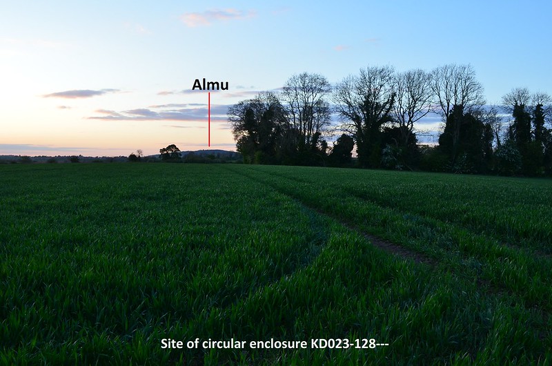
It has commanding views of the Chair hills on the west-northwest horizon and Almu/the Hill of Allen to the north. According to Irish Mythology, Fionn mac Cumhaill had a residence/hillfort on Almu, and the surrounding flatlands were used as training grounds for his band of warriors, the Fianna.
The Chair hills:
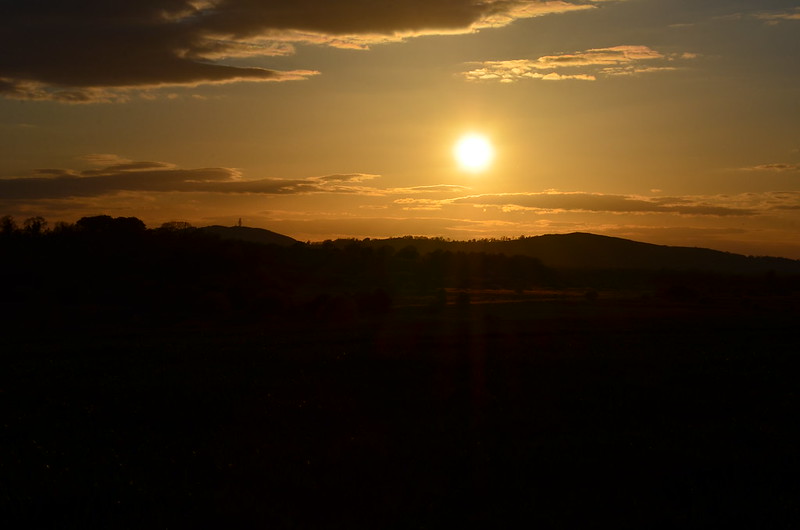
The images below show the sun approaching the summit of Grange hill (the peak on the far right), observed from the site of the circular enclosure KD023-128--- on the evening of May 4th, the evening before the official cross-quarter day of May 5th. The sun will also set at Grange at the August cross-quarter day as the sun continues its journey southward following the Summer solstice:


I hope to post soon on more interesting observations on the Curragh.0 -
KD023-048--- is a large trivallate ring-barrow situated on the eastern edge of the plains of the Curragh, Co. Kildare. It lies less than 150 metres south of the Exit 12 roundabout on the M7 (southbound).
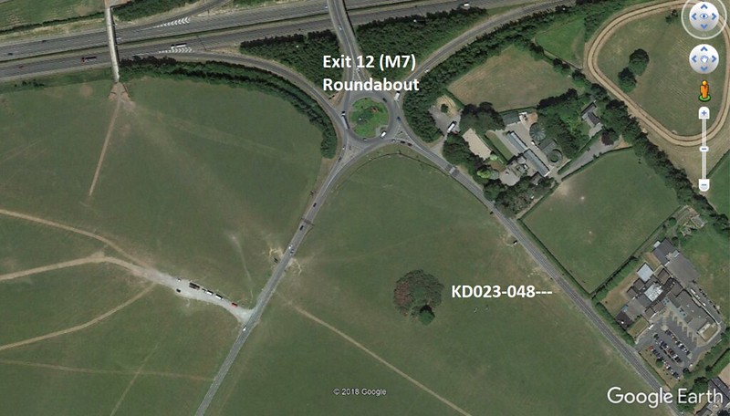
Most who have visited the Curragh would be familiar with the fabulous Fionn mac Cumhaill sculpture on that roundabout:
Trivallate ring-barrow KD023-048----:
When one is standing at this ring-barrow the Chair Hills are very much visible on the horizon to the Northwest:
Lugnaquilla is visible on the horizon to the Southeast:
Where both Lugnaquilla and the Chair Hills lie on the local horizon in relation to KD023-048--- peaked my curiosity. The summer solstice sun sets in the direction of the Chair hills and the winter solstice sun rises in the southeast. I had an inkling that the winter solstice sun would rise up from behind the summit of Lugnaquilla as one observed from ring-barrow KD023-048---. On the 22nd December, 2018, a rather cloudy morning, I took a few photos from the outer bank of KD023-048--- as the sun was rising in the southeast. With the cloudy, overcast conditions I didn't hold out much hope that I'd see anything of significance that morning, but a slight break in the clouds just at the right moment did indeed confirm that the winter solstice sun does rise from Lugnaquilla.
Winter solstice sunrise (2018) observed from KD023-048, with the sun peeping through a break in the clouds as it rises from Lugnaquilla: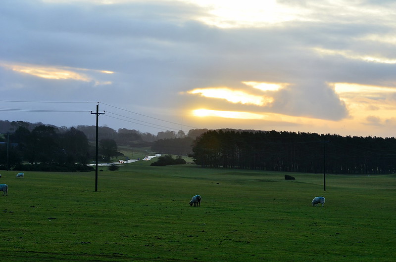
Last week I turned my attentions to the Chair Hills to the Northwest, and on Monday 17th June, I took several images as the sun set that evening while standing close to KD023-048---. Standing at KD023-048--- today, the view of Grange hill (one of the Chair hills) is obscured by trees, so I positioned myself a few hundred metres further along the suspected solstice alignment with a clearer view of Grange (in post #185 directly above this one, I posted images of the May cross-quarter sun setting at the summit of Grange observed from a circular enclosure I discovered recently just outside the Curragh). Although it was four evenings prior to the official solstice, the sun moves very little northwards in that period of time - approximately 0.1° azimuth - so what you see in the images below is very close to what one would see on the evening of the summer solstice on the 21st. (On the evening of the solstice itself, the sky was overcast, and unfortunately didn't manage to capture it).
The setting sun descending behind the summit of Grange hill to the northwest: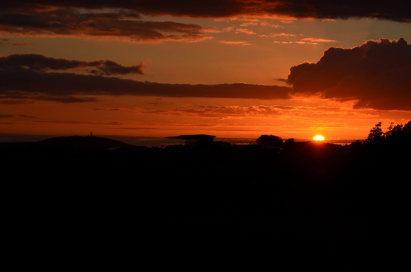
One other curious observation I made in recent years is where the sun sets on the evening of the winter solstice while standing at KD023-048---. On Long hill (now the Curragh military camp) an interesting linear feature was recorded on an 1838 Ordnance Survey Map. It comprised two parallel embankments, approximately 150 metres long and well over 50 metres wide and was recorded as the site of an encampment. Some have suggested this may not have been the site of an encampment, but possibly a Cursus. This linear feature is no longer extant, but I've observed the winter solstice sun setting at what would have been the northwest end of this linear feature when standing at KD023-048---.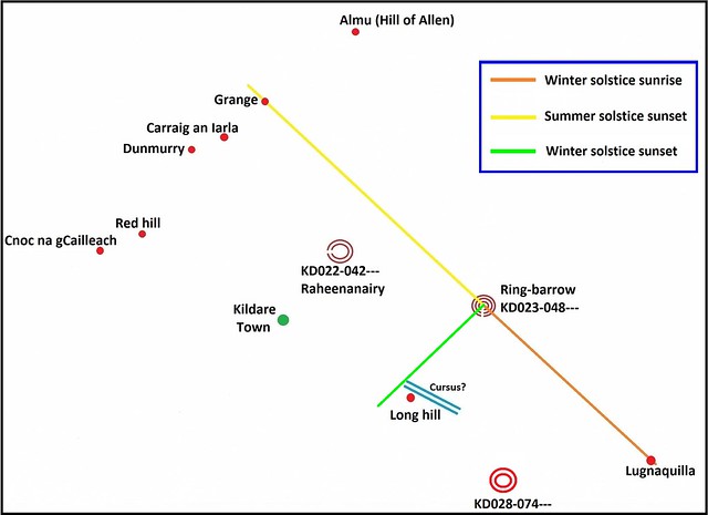
Interestingly enough, while the summer solstice sun is setting behind Grange hill when observing from KD023-048---, the sun is simultaneously setting behind the hill of Dunmurry when observing from ring-barrow KD028-074--- which lies 2.5 kilometres SE-S of KD023-048. Not only that, the solstice alignment from KD028-074 to the summit of the hill of Dunmurry also passes through the northwest end of the ?cursus? on Long hill, so one would see the summer solstice sun setting at the summit of Dunmurry from that spot too. I've posted about my observations of the summer solstice sunset from KD028-074 already in this thread - see post #179.0 -
Advertisement
-
Is it possible that druids would have been consulted prior to the construction of a new settlement, and they might choose sites with certain alignments to bring "luck" or good fortune to the future occupants?
Like a sort of feng shui, to please the gods or the ancestors.0 -
Join Date:Posts: 4959
It’s a possibility but we are looking at monuments that pre-date the druids by a long way!Is it possible that druids would have been consulted prior to the construction of a new settlement, and they might choose sites with certain alignments to bring "luck" or good fortune to the future occupants?
Like a sort of feng shui, to please the gods or the ancestors.0 -
Join Date:Posts: 4959
Great work Hotei...as ever. Really interesting possibilities.
A possible inter-relationship between linear monuments on Brewel Hill and Keadeen mountain was noted by Christiaan Corlett some time ago. The possibility of other lowland/upland relationships is genuinely intriguing.
These are really important observations and really valuable field work.0 -
slowburner wrote: »Great work Hotei...as ever. Really interesting possibilities.
A possible inter-relationship between linear monuments on Brewel Hill and Keadeen mountain was noted by Christiaan Corlett some time ago. The possibility of other lowland/upland relationships is genuinely intriguing.
These are really important observations and really valuable field work.
Thanks SB. I was beginning to think no one really cared!
Just a correction to my last post - I stated that the cursus-like linear feature on Long hill measured approximately 150 metres long, however, it actually measured just under one kilometre long which made it a pretty substantial structure indeed.
I've attached another illustration below (pretty basic looking and not to scale) showing some other curious alignments related to the cursus-like feature mentioned in the previous post above: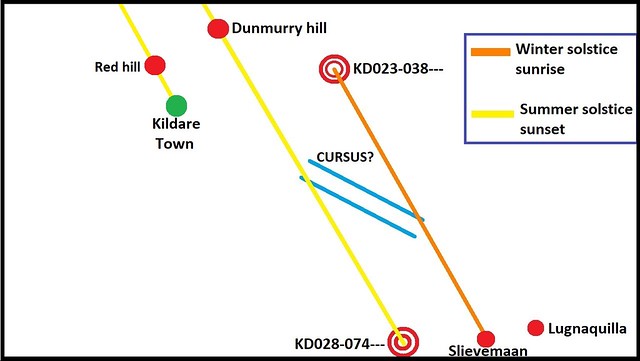
The cursus-like feature sat on Long hill (now site of the Curragh military camp) and had a NW-SE orientation. I mentioned in my previous post that an alignment from ring-barrow KD028-074--- to the summit of Dunmurry hill marked the summer solstice sunset (represented by the yellow line in the above illustration). A closer look shows that this line passes through the NW end (terminus?) of the linear feature on Long hill, so one would also see the summer solstice sun set at the summit of Dunmurry from the terminus too.
Several years ago, myself and baaba maal (another frequenter of this forum) visited ring-ditch KD023-038--- in the hope of seeing the winter solstice sun rise from Slievemaan in the Wicklow mountains to the SE. Although it was a beautiful crisp morning, clouds gathered very quickly on the SE horizon which would later scupper our chances of seeing the sunrise that morning. I managed to capture that sunrise the following year.
Ring-ditch KD023-038--- with a view of the roundtower and cathedral in Kildare town to the SW-W:
The winter solstice sun rising from the summit of Slievemaan (Sliabh meádhon, 'middle mountain') observed from ring-ditch KD023-038---. The higher peak to the left is Lugnaquilla: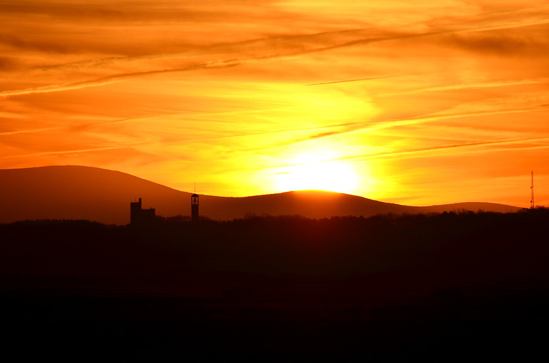

A closer look at the first sunrise image above shows a silhouette of the church spire and fire station on Long hill (Curragh military camp). The cursus-like linear feature recorded on an 1838 Ordnance Survey map, ran for almost a kilometre from just left of the church down past the aerial mast shown on the far right of the image.
If you scroll back up to my rather crude illustration above, you'll see where the orange line representing a winter solstice sunrise alignment from KD023-038--- to the summit of Slievemaan passes directly through the SE terminus of the linear feature on Long hill. Again, when standing at the SE terminus one would also see the sun rise from Slievemaan at winter solstice (I witnessed this myself back in 2015).
The NW-SE orientation of the cursus? is also rather curious in that I discovered it is oriented directly towards the site of St. Brigid's Cathedral and Roundtower in Kildare town to the NW. St. Brigid's was believed to be the site of a pre-Christian fire temple and something I alluded to in an earlier post in this thread - see post #139 (that post is now sadly devoid of images because I have since changed some security settings on my Flickr account, and yes, I was Bonedigger in a former incarnation!).
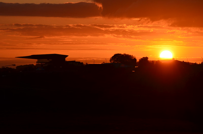
As I've shown it's possible to observe the winter solstice sun rise from Slievemaan from ring-ditch KD023-038---, but I've also discovered that it's possible to see the setting sun on the evenings of the November and February cross-quarter days (which represented the pagan festivals of Samhain and Imbolc) descend behind the site of St. Brigid's in Kildare town.
November cross-quarter day sunset (2015) observed from ring-ditch KD023-038--- setting at the site of St.Brigid's Cathedral in Kildare town (sunset on the February cross-quarter day will look almost identical):
In post #179, I outlined how it may have been possible that ring-barrow KD028-074--- (shown in the very first illustration above) may have helped mark a period of time from the May cross-quarter day through to the August cross-quarter day, so it's possible ring-ditch KD023-038--- may have played a similar role marking the period of time from the November cross-quarter through to the February cross-quarter. The sun at winter solstice can also be observed setting at the site of St. Brigid's Cathedral from two ring-barrows lying not far from ring-ditch KD023-038--- (see post #139).
Winter solstice sunset at St. Brigid's in Kildare town observed from ring-barrow KD022-043---: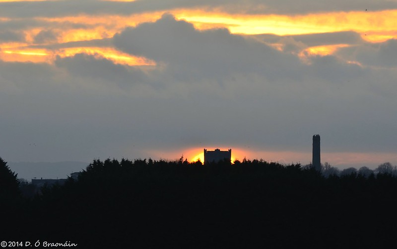 0
0 -
Truly fascinating stuff HM- what is fascinating is that each discovery you make seems to be backed up by the locations of other features. It is like you are unlocking the landscape.
There is definitely a book in this!0 -
Advertisement
-
Thanks very much baaba!0
-
HoteiMarkii wrote: »Thanks SB. I was beginning to think no one really cared!
Just a correction to my last post - I stated that the cursus-like linear feature on Long hill measured approximately 150 metres long, however, it actually measured just under one kilometre long which made it a pretty substantial structure indeed.
I've attached another illustration below (pretty basic looking and not to scale) showing some other curious alignments related to the cursus-like feature mentioned in the previous post above:
The cursus-like feature sat on Long hill (now site of the Curragh military camp) and had a NW-SE orientation. I mentioned in my previous post that an alignment from ring-barrow KD028-074--- to the summit of Dunmurry hill marked the summer solstice sunset (represented by the yellow line in the above illustration). A closer look shows that this line passes through the NW end (terminus?) of the linear feature on Long hill, so one would also see the summer solstice sun set at the summit of Dunmurry from the terminus too.
Several years ago, myself and baaba maal (another frequenter of this forum) visited ring-ditch KD023-038--- in the hope of seeing the winter solstice sun rise from Slievemaan in the Wicklow mountains to the SE. Although it was a beautiful crisp morning, clouds gathered very quickly on the SE horizon which would later scupper our chances of seeing the sunrise that morning. I managed to capture that sunrise the following year.
Ring-ditch KD023-038--- with a view of the roundtower and cathedral in Kildare town to the SW-W:
The winter solstice sun rising from the summit of Slievemaan (Sliabh meádhon, 'middle mountain') observed from ring-ditch KD023-038---. The higher peak to the left is Lugnaquilla:
A closer look at the first sunrise image above shows a silhouette of the church spire and fire station on Long hill (Curragh military camp). The cursus-like linear feature recorded on an 1838 Ordnance Survey map, ran for almost a kilometre from just left of the church down past the aerial mast shown on the far right of the image.
If you scroll back up to my rather crude illustration above, you'll see where the orange line representing a winter solstice sunrise alignment from KD023-038--- to the summit of Slievemaan passes directly through the SE terminus of the linear feature on Long hill. Again, when standing at the SE terminus one would also see the sun rise from Slievemaan at winter solstice (I witnessed this myself back in 2015).
The NW-SE orientation of the cursus? is also rather curious in that I discovered it is oriented directly towards the site of St. Brigid's Cathedral and Roundtower in Kildare town to the NW. St. Brigid's was believed to be the site of a pre-Christian fire temple and something I alluded to in an earlier post in this thread - see post #139 (that post is now sadly devoid of images because I have since changed some security settings on my Flickr account, and yes, I was Bonedigger in a former incarnation!).
As I've shown it's possible to observe the winter solstice sun rise from Slievemaan from ring-ditch KD023-038---, but I've also discovered that it's possible to see the setting sun on the evenings of the November and February cross-quarter days (which represented the pagan festivals of Samhain and Imbolc) descend behind the site of St. Brigid's in Kildare town.
November cross-quarter day sunset (2015) observed from ring-ditch KD023-038--- setting at the site of St.Brigid's Cathedral in Kildare town (sunset on the February cross-quarter day will look almost identical):
In post #179, I outlined how it may have been possible that ring-barrow KD028-074--- (shown in the very first illustration above) may have helped mark a period of time from the May cross-quarter day through to the August cross-quarter day, so it's possible ring-ditch KD023-038--- may have played a similar role marking the period of time from the November cross-quarter through to the February cross-quarter. The sun at winter solstice can also be observed setting at the site of St. Brigid's Cathedral from two ring-barrows lying not far from ring-ditch KD023-038--- (see post #139).
Winter solstice sunset at St. Brigid's in Kildare town observed from ring-barrow KD022-043---:
What would have originally stood on the site of the cathedral?
I would expect most of that area was heavily wooded at the time.0 -
Not sure, but most cathedrals stand on the site of an early Christian church, and a lot of them stand on sites of even earlier pagan religious significance.cfuserkildare wrote: »What would have originally stood on the site of the cathedral?
The general idea was to replace and dominate the earlier religion.0 -
Not sure, but most cathedrals stand on the site of an early Christian church, and a lot of them stand on sites of even earlier pagan religious significance.
The general idea was to replace and dominate the earlier religion.
From my experience the church/cathedral would be built near (max 400yards ) but not actually on the site of a pre Christian site.
eg Rodanstown, or Oughterard and Rathmore.
This seems to be how they were eventually accept, they would have co-existed for a reasonable overlap period.0 -
cfuserkildare wrote: »What would have originally stood on the site of the cathedral?
I would expect most of that area was heavily wooded at the time.
No one can give you a definitive answer as to what the site may have looked like in prehistory, but we do know that St. Brigid's was the site of an early Christian monastic settlement established circa 470 A.D. A model reconstruction of the early Christian settlement is on display in the visitor center in the cathedral, and although I don't have an image of that, it may have looked not unlike the illustration below:
Where the church in the above illustration is a stone built construct, it's likely the early church and buildings at St. Brigid's were all timber built.
An early Christian monk, Cogitosus, writing in the 7th Century A.D. alludes to the presence of a pagan fire temple on this site prior to the establishment of the monastic settlement. Some scholars have suggested it was a centre of pagan religious worship, a fire-cult dedicated to the goddess Brigid. The historian and archaeologist R.A.S. Macalister argued that Brigid was a leader of a coven of priestesses devoted to a pagan fire-cult at the site of a sacred oak who persuaded her charges to adopt the new religion of Christianity (source - Catherine Swift: Brigid, Patrick and the Kings of Kildare, A.D. 640-850; Kildare:History & Society).0 -
A big bonfire lighting up just as the sun set in that exact spot would have been quite an impressive sight alright.0
-
The images below were captured by myself on the evening of the summer solstice in 2015 as the sun descended behind the summit of Red hill which lies 3.5 kilometres NW of the site of St. Brigid's cathedral in Kildare town. It was once possible to observe this solstice sunset from the site of St. Brigid's, but today a view of the summit of Red hill is obscured by large trees and buildings close by. Red hill has a trivallate ring-barrow at its summit.
 0
0 -
HoteiMarkii wrote: »No one can give you a definitive answer as to what the site may have looked like in prehistory, but we do know that St. Brigid's was the site of an early Christian monastic settlement established circa 470 A.D. A model reconstruction of the early Christian settlement is on display in the visitor center in the cathedral, and although I don't have an image of that, it may have looked not unlike the illustration below:
Where the church in the above illustration is a stone built construct, it's likely the early church and buildings at St. Brigid's were all timber built.
An early Christian monk, Cogitosus, writing in the 7th Century A.D. alludes to the presence of a pagan fire temple on this site prior to the establishment of the monastic settlement. Some scholars have suggested it was a centre of pagan religious worship, a fire-cult dedicated to the goddess Brigid. The historian and archaeologist R.A.S. Macalister argued that Brigid was a leader of a coven of priestesses devoted to a pagan fire-cult at the site of a sacred oak who persuaded her charges to adopt the new religion of Christianity (source - Catherine Swift: Brigid, Patrick and the Kings of Kildare, A.D. 640-850; Kildare:History & Society).
That would explain the Fire Pit at the back of the cathedral.0


 https://www.youtube.com/watch?v=skcCu4RUkAg

Advertisement