Advertisement
If you have a new account but are having problems posting or verifying your account, please email us on hello@boards.ie for help. Thanks :)
Hello all! Please ensure that you are posting a new thread or question in the appropriate forum. The Feedback forum is overwhelmed with questions that are having to be moved elsewhere. If you need help to verify your account contact hello@boards.ie
Hi all,
Vanilla are planning an update to the site on April 24th (next Wednesday). It is a major PHP8 update which is expected to boost performance across the site. The site will be down from 7pm and it is expected to take about an hour to complete. We appreciate your patience during the update.
Thanks all.

Interesting Maps

Options
12122242627234

Comments

  • Closed Accounts Posts: 1,076 ✭✭✭Wayne Jarvis


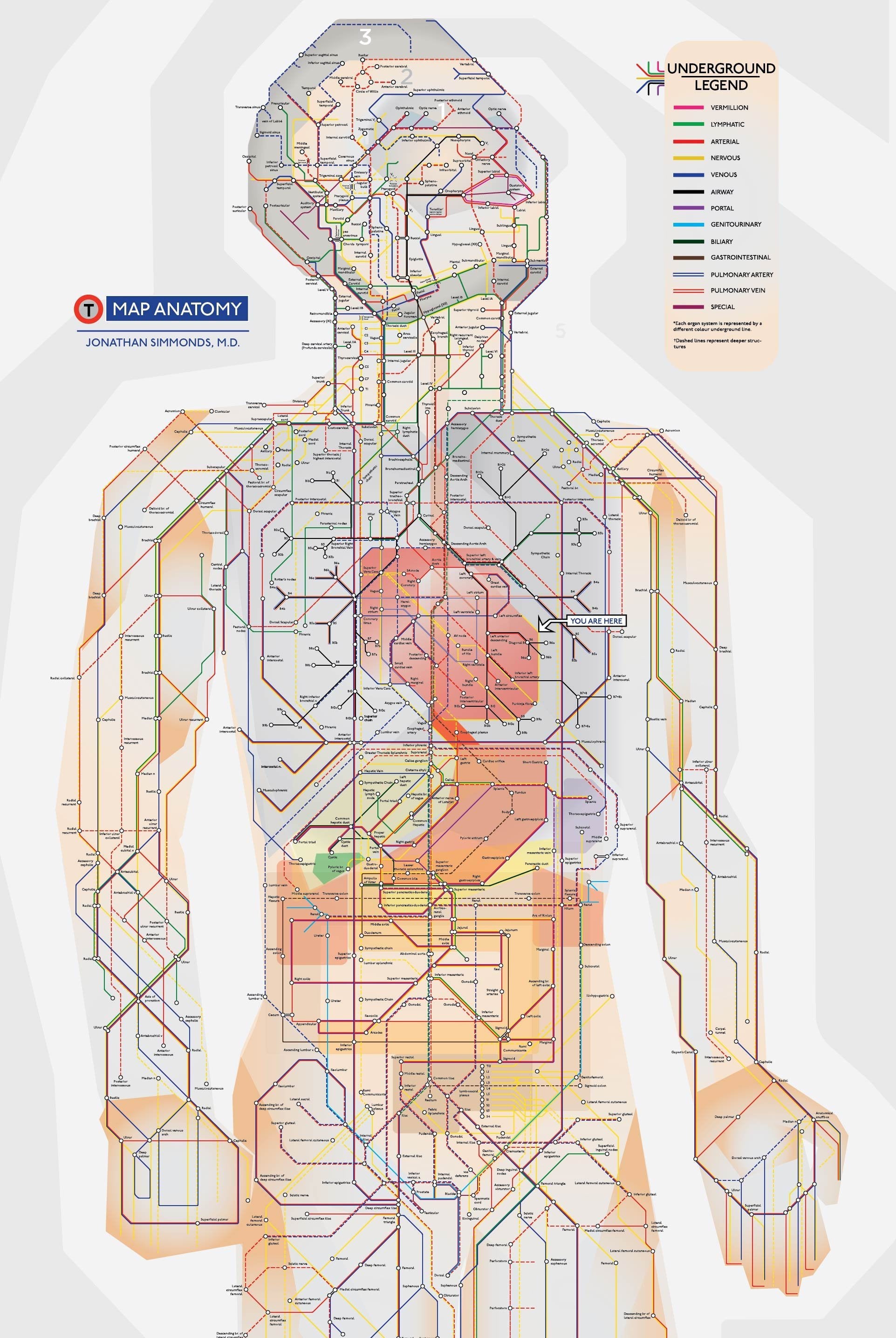
    A map of the human body done in the style of the London Underground.


    Map-Anatomy-London-Undergroun.jpg


  • Moderators, Politics Moderators Posts: 38,855 Mod ✭✭✭✭Seth Brundle


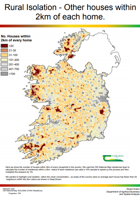
    This map created by Teagasc looks at geographic isolation in the context of the new rules on social distancing and travel within 2km.

    614091227332263936

    Teagasc calculated how many houses every household in the country has within a 2km radius to highlight those areas of the country where geographic isolation adds to the social isolation rules. Naturally enough these areas are also isolated form a whole range of services.
    Your image is socially distancing itself too :D
    4006a8bc5077043b001803107a6f0a782d1f0fda.png


  • Registered Users Posts: 1,924 ✭✭✭WesternZulu


    Your image is socially distancing itself too :D

    Thanks; who knew attaching an image would be so difficult :o


  • Moderators, Politics Moderators Posts: 38,855 Mod ✭✭✭✭Seth Brundle


    Thanks; who knew attaching an image would be so difficult :o
    Years of experience from making my own mistakes


  • Registered Users Posts: 19,678 ✭✭✭✭cnocbui


    Apparently some Australians are unhappy with their government's handling of the Covid-19 crisis, which has resulted in a proposal for a new map:

    90297967_10158496491287845_5664894321044750336_o.jpg?_nc_cat=1&_nc_sid=8024bb&_nc_oc=AQlUCjRhrzlbVKceqx41Va7LwYh74XmnoGliX6eYCbBh4Nm5tLPtwZiP7Cqfg1_MUoID2jJrhHrHsL8dEb3NWYkt&_nc_ht=scontent-dub4-1.xx&oh=cc0517a006ee4457380f8083acee2df5&oe=5EA88DB3
    :)


  • Advertisement
  • Closed Accounts Posts: 234 ✭✭Shady Grady


    Guy Person wrote: »
    A map of the human body done in the style of the London Underground.


    Map-Anatomy-London-Undergroun.jpg

    **** I'm lost already.


  • Registered Users Posts: 1,846 ✭✭✭dball


    http://map.geohive.ie/mapviewer.html

    You can change the layers here from old 6" maps to modern. It's a cracking resource.

    now, that's a map. great find OP and greater resource.

    wow


  • Registered Users Posts: 25,420 ✭✭✭✭sligojoek


    dball wrote: »
    now, that's a map. great find OP and greater resource.

    wow

    Yes. I spent an hour on it the other night. I'll be going back to it again.


  • Moderators, Politics Moderators Posts: 38,855 Mod ✭✭✭✭Seth Brundle


    **** I'm lost already.
    Maybe start off with some basic medical knowledge and work your way up...


  • Moderators, Politics Moderators Posts: 38,855 Mod ✭✭✭✭Seth Brundle


    sligojoek wrote: »
    Yes. I spent an hour on it the other night. I'll be going back to it again.
    I love looking at the old 25" maps from a century ago and see how a place has changed.


  • Advertisement
  • Registered Users Posts: 2,297 ✭✭✭Hoop66


    Victor wrote: »
    Do not fold them - it will damage them and devalue them.

    They are already folded up. I was wondering whether they are worth more to a collector unfolded.


  • Politics Moderators, Social & Fun Moderators, Society & Culture Moderators Posts: 22,655 Mod ✭✭✭✭Tokyo


    One of my favourite maps, as not much has changed between then and now. Have a framed version hanging in my living room.

    pBBsgxBh.jpg


  • Registered Users Posts: 21,517 ✭✭✭✭Tell me how


    ^^^^^

    Any ideas why recently certain images are not showing for me on google chrome. This post is blank for me aside from the text and I have noticed this quite a bit recently.
    Am using Chrome Version 80.0.3987.162 (Official Build) (64-bit)


  • Politics Moderators, Social & Fun Moderators, Society & Culture Moderators Posts: 22,655 Mod ✭✭✭✭Tokyo


    ^^^^^

    Any ideas why recently certain images are not showing for me on google chrome. This post is blank for me aside from the text and I have noticed this quite a bit recently.
    Am using Chrome Version 80.0.3987.162 (Official Build) (64-bit)

    Is imgur blocked for you?


  • Registered Users Posts: 21,517 ✭✭✭✭Tell me how


    mike_ie wrote: »
    Is imgur blocked for you?

    Not by choice. Can browse to the site and view images on it without issue.

    Edit: The image now loaded...........


  • Politics Moderators, Social & Fun Moderators, Society & Culture Moderators Posts: 22,655 Mod ✭✭✭✭Tokyo


    might be worth trying another browser to see if it's browser related, or if something is more globally blocked on your end.


  • Registered Users Posts: 3,359 ✭✭✭davetherave


    There is a plethora of old maps listed here on the UCD Library to browse through

    Historic Maps of Dublin: https://libguides.ucd.ie/findingmaps/mapshistDublin
    Historic Maps of Ireland: https://libguides.ucd.ie/findingmaps/mapshistIreland


    This is an exact survey of the city and suburbs of Dublin from 1756 by John Rocque

    https://iiif.lib.harvard.edu/manifests/view/ids:10135320


  • Registered Users Posts: 4,682 ✭✭✭ablelocks


    gloriously detailed maps

    image.jpg
    The Mystery Map of Assinine Atoll

    image.jpg
    Panorama of the New York Zoological Park

    atlasobscura site...


    (don't think it's been posted already, but apologies if it has)


  • Registered Users Posts: 1,986 ✭✭✭Noo


    This is probably a lot more interesting if you are familiar with Brisbane, but I still think it would be appreciated here.
    "Google Earth" from 1946.

    This is not mobile friendly so will work best on a desktop.
    I have to give instructions as its an interactive map so won't let me directly link the 1946 stuff.

    http://cityplan2014maps.brisbane.qld.gov.au/CityPlan/

    Click "Map Contents" on the left, then "Aerial", then the drop down arrow for Aerial and tah dah! you can directly compare imagery from 1946 and 2012 for the whole city.


  • Registered Users Posts: 926 ✭✭✭Icaras


    Japanese Pearl harbor maps. On mobile so just giving the web page
    https://blogs.loc.gov/loc/2020/03/japanese-pilots-map-of-pearl-harbor-attack-now-at-library/


  • Advertisement
  • Posts: 0 [Deleted User]


    Icaras wrote: »
    Japanese Pearl harbor maps. On mobile so just giving the web page
    https://blogs.loc.gov/loc/2020/03/japanese-pilots-map-of-pearl-harbor-attack-now-at-library/

    Absolutely fascinating thanks


  • Moderators, Recreation & Hobbies Moderators, Science, Health & Environment Moderators, Technology & Internet Moderators Posts: 90,700 Mod ✭✭✭✭Capt'n Midnight


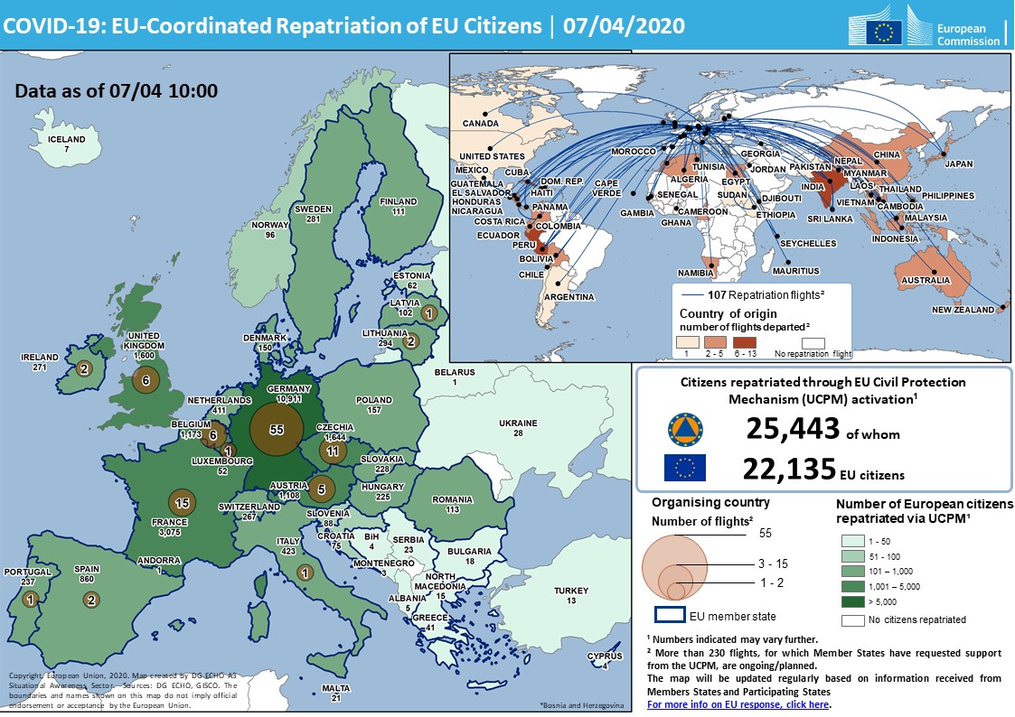
    EVAmLhbUcAAyDiI?format=jpg


    from twitter.com/eu_echo/status/1247545314019549187


  • Closed Accounts Posts: 1,076 ✭✭✭Wayne Jarvis


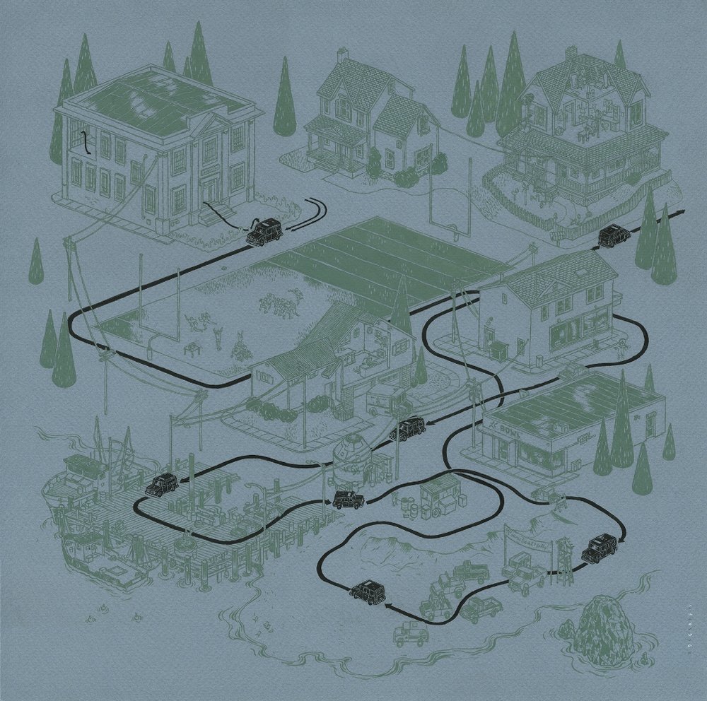
    From Andrew DeGraff. He does maps of where movies are set and where the main characters go in them. Here is his one from my favourite movie Shaun of the Dead.


    pathofshaun1.jpg?format=1000w


  • Closed Accounts Posts: 1,076 ✭✭✭Wayne Jarvis


    And from The Goonies which is set both above ground and underground so a map for each.


    pursuitofthefratellis3.jpg?format=1000w


    gooniesmap2.jpg?format=1000w


  • Registered Users Posts: 25,420 ✭✭✭✭sligojoek


    John Creedon's Atlas of Ireland is on RTE1 now. Discussing the early days of Ordnance Survey Ireland.


  • Registered Users Posts: 18,921 ✭✭✭✭BonnieSituation


    sligojoek wrote: »
    John Creedon's Atlas of Ireland is on RTE1 now. Discussing the early days of Ordnance Survey Ireland.

    I've worked for the OSI in the past (I'm a Surveyor/GIS analyst) and some of the stories about the Triangulation of Ireland just blow my mind.

    Even knowing the science behind it and the skills involved, I can still never get my head into the people that did that excruciating work, with primitive equipment, over the course of those 8 years! I hated even setting out small fields!

    They have the original Colby's Bars from the Foyle Baseline Measurement in the Park HQ.

    The misclosures and errors of the whole project are insane even by modern standards:

    - Average misclosure of 2.8sec of arc in the triangles
    - Foyle base measurement was within 5 inches of the Salisbury Plain base measurement (through the triangles)
    - The baseline was found in 1960 to be out by 1 inch over its 8 mile length ie. 1:506880 :eek::eek::eek::eek:

    https://www.osi.ie/wp-content/uploads/2015/04/The-Irish-Grid-A-Description-of-the-Coordinate-Reference-System-Used-in-Ireland.pdf

    https://www.osi.ie/about/history/interior-survey/

    Decent reads there if a bit technical. But should give an outline to those that want to know the madness involved in old school mapping.


  • Registered Users Posts: 25,420 ✭✭✭✭sligojoek


    Very interesting , Bonnie.

    I'll look at those links again. The OSI stuff was just in the first segment. As luck would have it I wasn't able to listen to that bit. The rest was looking at the origins of placenames in Derry, Donegal, Leitrim and Cavan. He spoke a lot about a guy called O Donovan (I missed his first name) Who did a lot of surveying and researching names of townslands. Seemed like a really interesting guy.


  • Registered Users Posts: 18,921 ✭✭✭✭BonnieSituation


    sligojoek wrote: »
    Very interesting , Bonnie.

    I'll look at those links again. The OSI stuff was just in the first segment. As luck would have it I wasn't able to listen to that bit. The rest was looking at the origins of placenames in Derry, Donegal, Leitrim and Cavan. He spoke a lot about a guy called O Donovan (I missed his first name) Who did a lot of surveying and researching names of townslands. Seemed like a really interesting guy.


    Placenames (toponoymy) are my first love as it happens!

    Check out www.logainm.ie

    John/Sean O'Donovan's research is second to none. An incredible survey and historical record.

    https://www.logainm.ie/Eolas/Data/Brainse/logainm.ie-lamhscribhinn-sheain-ui-dhonnabhain.pdf

    Link to his ledger.


    General Toponymy resources:

    https://www.logainm.ie/en/res/

    Him working for the OS is the reason why we have a lot of dual spelling of English place-names as the Post Office at the time had their own records.

    So this is why you have things like Ballinagh/Bellananagh in Cavan and Mallaranny/Mulrany in Mayo.


    I could go on all night!


  • Registered Users Posts: 10,117 ✭✭✭✭Junkyard Tom


    https://blueshift.io/

    Visual representation of immigration to the US. Pretty.


  • Advertisement
  • Registered Users Posts: 25,420 ✭✭✭✭sligojoek


    Placenames (toponoymy) are my first love as it happens!

    Check out www.logainm.ie

    John/Sean O'Donovan's research is second to none. An incredible survey and historical record.

    https://www.logainm.ie/Eolas/Data/Brainse/logainm.ie-lamhscribhinn-sheain-ui-dhonnabhain.pdf

    Link to his ledger.


    General Toponymy resources:

    https://www.logainm.ie/en/res/

    Him working for the OS is the reason why we have a lot of dual spelling of English place-names as the Post Office at the time had their own records.

    So this is why you have things like Ballinagh/Bellananagh in Cavan and Mallaranny/Mulrany in Mayo.


    I could go on all night!

    Thanks again. I'm far from an expert but love this king of thing. I'll have to find out why a Y changed to an E in my home village.


Advertisement