Advertisement
If you have a new account but are having problems posting or verifying your account, please email us on hello@boards.ie for help. Thanks :)
Hello all! Please ensure that you are posting a new thread or question in the appropriate forum. The Feedback forum is overwhelmed with questions that are having to be moved elsewhere. If you need help to verify your account contact hello@boards.ie
Hi all! We have been experiencing an issue on site where threads have been missing the latest postings. The platform host Vanilla are working on this issue. A workaround that has been used by some is to navigate back from 1 to 10+ pages to re-sync the thread and this will then show the latest posts. Thanks, Mike.
Hi there,
There is an issue with role permissions that is being worked on at the moment.
If you are having trouble with access or permissions on regional forums please post here to get access: https://www.boards.ie/discussion/2058365403/you-do-not-have-permission-for-that#latest

Bus Stop Of The Month

  • 10-04-2019 9:57am
    #1
    Registered Users, Registered Users 2 Posts: 3,046 ✭✭✭


    A new feature I thought I would start, which acts as a counterpoint to Throwback Thursday. That is about us in the present looking back at the past, whereas this is finding relics of the past that are still with us in the present.

    To begin with, we start on Gilford Park in Sandymount. This bus stop was served by the original route 52 which connected the City Centre with Sandymount. The last 52 served this stop on 1st February 1986 when the route was changed to connect Kilmacud with Sydney Parade. It is interesting that the bus stop was repainted green at least a year later when Dublin Bus started in February 1987. Some of the original CIE navy blue is also visible. 05/04/2019

    33700687398_6954d0bfeb_c.jpgBus Stop Of The Month (1) by Cathal O'Brien, on Flickr


«1

Comments

  • Registered Users, Registered Users 2 Posts: 3,046 ✭✭✭Csalem


    Our second bus stop of the month is on Amiens Street in Dublin City Centre. This bus stop retains its id number of 1501. It was formerly served by route 90 which connects the stations of Dublin Connolly with Dublin Heuston, via Tara Street. 1501 was in use when 'The Ramp' still existed at Connolly, a roadway that rose up from Amiens Street to the main station entrance. This was the first stop after leaving Connolly and is opposite Bus Aras. When the Luas works removed the ramp, and the tram connected the two main stations in the early 2000s, the 90 reduced in frequency and ceased to use 1501. The bus stop retains its Dublin Bus blue paint which came after the green era.

    Stop 1500 is still in service at Connolly Station on Amiens Street and 1502 is on George's Quay at Tara Street Station. 07/04/19

    47902354601_eb05cf9a53_c.jpgBus Stop Of The Month (2) by Cathal O'Brien, on Flickr


  • Registered Users, Registered Users 2 Posts: 3,046 ✭✭✭Csalem


    This month we are in my home town of Balbriggan, and have a bit of a mystery. I believe this is one of the rare bus stops that was installed but never used. Let me explain why. The 33 has served Balbriggan for many decades. In the early days it terminated on Dublin Street outside the Bank Of Ireland, and did a loop around the town to get to and from that stop. Therefore as it arrived into the terminus it would have passed the location of this bus stop on Hampton Street. However, in the mid to late 1980s the terminus moved to the opposite side of Dublin Bus. Therefore the outbound 33 used the other lane on Hampton Street and this bus stop would not have been served.
    To odd a further complication to this mystery, this bus stop has a number - 6046. With such a high number, it means it dates from the 1990s (if not later). Most new bus stops now are in the 7000s. Therefore this stop dates from after the 33 passed this way. The current Dublin Bus stop list has no 6045, but 6044 is located in Dundrum near the Luas stop. Incrementing, there is no active 6047 but there is a 6048. It is in Balbriggan but it does not exist, nor has it ever. The map locates it on Dublin Street between the 33 terminus and the junction with Old Market Green. It even is shown on the internal display on the 33 as a stop.
    I believe the mystery of stop 6046 dates back to when the 33 relocated its terminus in Balbriggan from opposite the Bank of Ireland to the church where it is now. I think the relocation was due to roadworks taking place in the town and there were a number of options considered to reroute the 33. Going back via Hampton Street was one of them and this stop was installed to facilitate that, but instead the present routing was chosen instead and 6046 has never seen a passenger. It would also explain why it is blue as that was the colour of that era (early 2000s).
    If anyone knows anything more, please leave a comment below. 06/04/19

    48078064191_f8286d56ed_c.jpgBus Stop Of The Month (3) by Cathal O'Brien, on Flickr


  • Registered Users, Registered Users 2 Posts: 3,046 ✭✭✭Csalem


    This month we are going back to green. This bus stop is located on Victoria Road in Clontarf. It used to be served by route 44A until that route was absorbed into City Imp route 130 in 1996. The 44A connected the City Centre with Mount Prospect Avenue in Clontarf, serving Haddon Road, Victoria Road, Castle Avenue, Blackheath Park and Seafield Road. When the 130 started, it represented a merging of the 44A with the 30 and Haddon Road and Victoria Road lost their bus services. The part of Castle Avenue in the background is still served by the 104 today.
    20/07/19

    48339120062_85b2f2bb9e_c.jpgBus Stop Of The Month (4) by Cathal O'Brien, on Flickr


  • Registered Users, Registered Users 2 Posts: 3,046 ✭✭✭Csalem


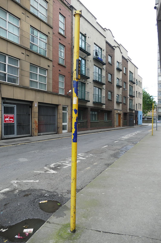
    Two for the price of one this month. and also our first yellow bus stops. Corn Exchange Place might also be the closest this feature gets to the City Centre, being a mere 250 metres from O'Connell Bridge. The road is located between Poolbeg Street and Burgh Quay, both busy bus routes, but is sort of tucked away out of site. For decades the Irish Press Building stood on the right-hand side of the photograph but was demolished and replaced by the Garda National Immigration Bureau building in the early 2000s. Over the years this road served as the terminus for routes such as the 45, 84X and 134.
    The 45 connected the City Centre with Bray. In 2009 that route was cut back from the city and terminated in Ballsbridge, before later that year returning to Merrion Square. The 84X is an Xpresso route to various towns in north Wicklow. By 2012 it had moved its terminus to Grafton Street, outside Trinity College. In 2017 it moved to Hawkins Street, around the corner from Corn Exchange Place. The 134 was the City Imp route to Finglas. In the early 2000s it was merged with the 83 and became a cross-city route.
    In the foreground is stop 4483, while the stop in the background has no identification number. The nearest active stops in the Real Time Passenger Information system are 4481 and 4485, both in Cabra. 08/06/2019

    48623446328_42fed8e818_c.jpgBus Stop Of The Month (5) by Cathal O'Brien, on Flickr


  • Registered Users, Registered Users 2 Posts: 69,538 ✭✭✭✭L1011


    As far as I know the frame of the old Press building was retained and reshelled, possibly due to the structure being too strong to quickly demolish - having been built to carry printing presses and paper stock etc.

    That said I may be misremembering that!


  • Advertisement
  • Registered Users, Registered Users 2 Posts: 3,046 ✭✭✭Csalem


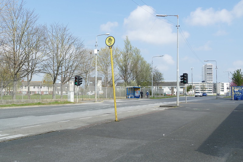
    Another two for one this month, and a chance to see stops that were once busy now unserved. In the foreground is stop 7190 while in the background is stop 101. Both are located on Sillogue Road, behind the former Ballymun Shopping Centre. 7190 itself is a replacement for another bus stop that once stood here which had a similar bus shelter to 101 in the background. The stops at this location were once the main stops for the centre of Ballymun. However when the regeneration project started in the late-1990s/early-2000s, iot was not just the high-rise flats that were demolished. The roundabout on the Ballymun Road at the shopping centre was removed and a new cross junction was installed connecting Balbutcher Lane, Shangan Road and Ballymun Road. Buses were therefore diverted away from Sillogue Road and these bus stops.
    Over the years these stops were used by routes 13, 13A, 36, 36A and 220. However the last route to serve these stops was one of the most pointless routes ever - 221. It ran from Shangan Road to Sillogue Road with a journey time of less than 5 minutes. It was the shortest route in Dublin. It ran from October 2011 to May 2012. It might have been for this route that stop 7190 was installed. Its high number contrasting with the older 101.
    Stop 7190 is in current Dublin Bus yellow, and stop 101 has a yellow head. However the shelter is CitySwift blue whcih was introduced in the mid-1990s and specifically referred to the 13/A here.
    13/04/2019

    48750594786_604491b5f9_c.jpgBus Stop Of The Month (6) by Cathal O'Brien, on Flickr


  • Registered Users, Registered Users 2 Posts: 3,046 ✭✭✭Csalem


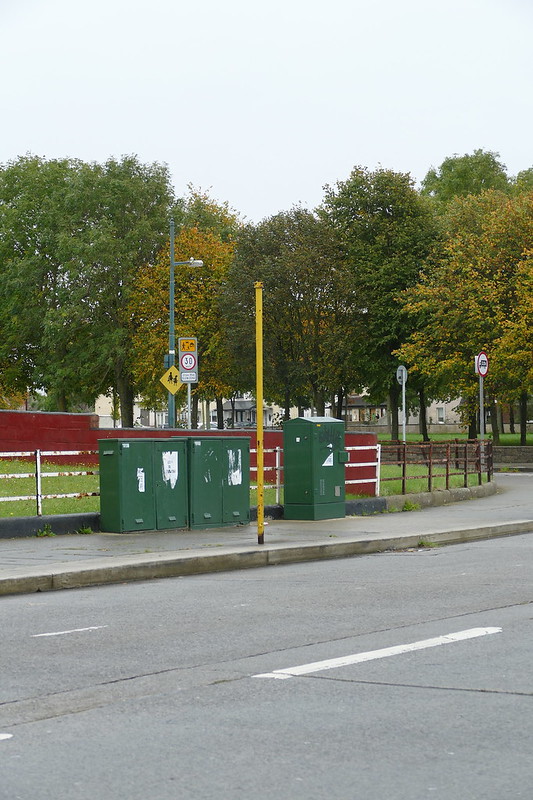
    This month we are on Dublin's northside in Edenmore on the Springdale Road. This bus stop (which has no number) is close to the junction with Edenmore Green. That latter road is still served today by the 27A, which also serves Springdale Road further west. But the stretch between Edenmore Green and Edenmore Park lost its bus service ten years ago.
    One of the first routes to serve this road was the 42B in 1988. At the time that route was merged with the 42A as part of a route reorganisation in the area. This lasted until 1996 when the 42B was rerouted via Edenmore Grove. However, that same year saw the introduction of route 300 which ran from Omni Park to Killester, and served this part of Springdale Road. It lasted until 2000. The final route in our story is the 129. It started in 2001 as peak-time extra service, running from Baldoyle to Waterloo Road. It used the full length of the Springdale Road to get from the Raheny Road to Coolock. The route lasted until 2009, and was the last route to serve this stop.
    The pole is in Dublin Bus yellow. 19/10/2019

    48937479782_daf75b17be_c.jpgBus Stop Of The Month (7) by Cathal O'Brien, on Flickr


  • Registered Users, Registered Users 2 Posts: 3,046 ✭✭✭Csalem


    This month we are heading to the coast and a blue bus stop on Seapoint Avenue. This route is currently unserved by buses, mainly because it runs parallel to the railway line with the frequent DART service. In fact, the entrance to Sepaoint Station is just beyond the bus stop. However in the past this stretch of road was served by the 17. More specifically it was served by the 17 on Summer Saturday's. The route (which ran from Dolphin's Barn to Blackrock) was extended to Seapoint in order to bring people to the seaside. This ran for a number of years but ceased in the 1990s.
    This bus stop though was installed in the early 2000s, hence it being in Dublin Bus dark blue. Due to roadworks in the Monkstown area, the 7 was diverted along here and away from its regular route of the Monkstown Road. Unfortunately this stop did not receive a number tag on the pole and therefore remains anonymous. 19/10/2019

    49124120977_a8a72e7ec5_c.jpgBus Stop Of The Month (8) by Cathal O'Brien, on Flickr


  • Registered Users, Registered Users 2 Posts: 10,427 ✭✭✭✭Marcusm


    Csalem wrote: »
    This month we are in my home town of Balbriggan, and have a bit of a mystery. I believe this is one of the rare bus stops that was installed but never used. Let me explain why. The 33 has served Balbriggan for many decades. In the early days it terminated on Dublin Street outside the Bank Of Ireland, and did a loop around the town to get to and from that stop. Therefore as it arrived into the terminus it would have passed the location of this bus stop on Hampton Street. However, in the mid to late 1980s the terminus moved to the opposite side of Dublin Bus. Therefore the outbound 33 used the other lane on Hampton Street and this bus stop would not have been served.
    To odd a further complication to this mystery, this bus stop has a number - 6046. With such a high number, it means it dates from the 1990s (if not later). Most new bus stops now are in the 7000s. Therefore this stop dates from after the 33 passed this way. The current Dublin Bus stop list has no 6045, but 6044 is located in Dundrum near the Luas stop. Incrementing, there is no active 6047 but there is a 6048. It is in Balbriggan but it does not exist, nor has it ever. The map locates it on Dublin Street between the 33 terminus and the junction with Old Market Green. It even is shown on the internal display on the 33 as a stop.
    I believe the mystery of stop 6046 dates back to when the 33 relocated its terminus in Balbriggan from opposite the Bank of Ireland to the church where it is now. I think the relocation was due to roadworks taking place in the town and there were a number of options considered to reroute the 33. Going back via Hampton Street was one of them and this stop was installed to facilitate that, but instead the present routing was chosen instead and 6046 has never seen a passenger. It would also explain why it is blue as that was the colour of that era (early 2000s).
    If anyone knows anything more, please leave a comment below. 06/04/19

    48078064191_f8286d56ed_c.jpgBus Stop Of The Month (3) by Cathal O'Brien, on Flickr

    If it was never used, can it really be called a bus stop, an existentialist quandary. I love threads like this; kudos to the OP.


  • Registered Users Posts: 181 ✭✭Contrails


    Marcusm wrote: »
    If it was never used, can it really be called a bus stop, an existentialist quandary. I love threads like this; kudos to the OP.

    "Indiscriminate pole of the month


  • Advertisement
  • Registered Users, Registered Users 2 Posts: 3,046 ✭✭✭Csalem


    This month's bus stop is a recent addition to the network but one that had a short working life. Stop 7371 is located on Sir John Rogerson's Quay, on the southern banks of the River Liffey. This part of the city was first served in 2009 by routes 74 and 74A. These routes connected Stocking Avenue, near Templeogue, with Britain Quay in the Grand Canal Dock area. In late 2011 these routes were abolished and the 15A and 15B were extended down to Britain Quay from Eden Quay. Interestingly the bus destination displays showed Benson Street, and although bus bays were marked out there, no bus ever terminated there due to the constant construction works in the docklands. Sir John Rogerson's Quay and Stop 7371 were only served by the outbound 15A and 15B as inbound the bus routes used the north quays and the Samuel Beckett Bridge. In 2017 the terminus was relocated from Britain Quay to Ringsend Road due to construction works in the area. The routes were finally rerouted again in 2018 when they took the more direct route to / from Ringsend Road via Pearse Street and Townsend Street. Stop 7371 was in service for less than a decade and spent all that time in Dublin Bus yellow. 30/11/2019

    49200713347_2fe63c6af2_c.jpgBus Stop Of The Month (9) by Cathal O'Brien, on Flickr


  • Registered Users, Registered Users 2 Posts: 19,085 ✭✭✭✭BonnieSituation


    How have I never seen this thread before.

    Quality as always Csalem.


  • Registered Users, Registered Users 2 Posts: 3,046 ✭✭✭Csalem


    Thanks. I always like trying to find interesting historical parts of the bus network to share, but never quite sure if anyone else find these as interesting. Headless old bus stops is quite niche!


  • Registered Users, Registered Users 2 Posts: 78,490 ✭✭✭✭Victor


    Csalem wrote: »
    This month we are heading to the coast and a blue bus stop on Seapoint Avenue. This route is currently unserved by buses, mainly because it runs parallel to the railway line with the frequent DART service. In fact, the entrance to Sepaoint Station is just beyond the bus stop. However in the past this stretch of road was served by the 17. More specifically it was served by the 17 on Summer Saturday's. The route (which ran from Dolphin's Barn to Blackrock) was extended to Seapoint in order to bring people to the seaside. This ran for a number of years but ceased in the 1990s.
    This bus stop though was installed in the early 2000s, hence it being in Dublin Bus dark blue. Due to roadworks in the Monkstown area, the 7 was diverted along here and away from its regular route of the Monkstown Road. Unfortunately this stop did not receive a number tag on the pole and therefore remains anonymous. 19/10/2019
    Just wondering it you reported this stop as a safety hazard?


  • Registered Users, Registered Users 2 Posts: 5,795 ✭✭✭Isambard


    Can we have a vote on the Pole of the Month?

    a Pole Poll I guess. They have one in Gdansk I hear


  • Registered Users, Registered Users 2 Posts: 3,046 ✭✭✭Csalem


    Victor wrote: »
    Just wondering it you reported this stop as a safety hazard?

    No


  • Registered Users, Registered Users 2 Posts: 3,046 ✭✭✭Csalem


    We are staying on the south quays these month, but have a new style of pole. Around 2008 Dublin Bus starting installing Trueform bus stops around the city, predominately in the city centre but other (busy) stops got them too. They are a design that feature predominately in London. The information panel provided clearer, and easier to update, information compared to the carousels used on the other poles. The heads featured tiles with the route numbers that could be easily replaced or modified when changes took place.
    Stop 4719 on George's Quay had a relatively short career. Between 2011 and 2012, Network Direct changes saw routes 14, 15 and 27 become cross-city routes. On the northside they all used the Malahide Road. On their southbound journies they came down Amiens Street, across the Talbot Memorial Bridge and along the south quays. Northbound they used Eden Quay, Beresford Place and Amiens Street. The 151 also took this southbound routing from Amiens Street. Prior to the 151 commencing in 2007, the only bus route that regularly used that routing was the 90, running between Connolly and Heuston. However it used stop 1502, closer to Tara Street Station than stop 4719. In 2014 the Rosie Hackett Bridge opened between Marlborough Street and Hawkins Street, crossing the Liffey. The 14, 15, 27 and 151 were diverted along a new contraflow bus lane on Custom House Quay and served Eden Quay in both directions. Stop 4719 then fell out of use, and the 90 became the only bus route again to use George's Quay (apart from regional services). The next stop in the sequence, 4720, is used by the 69 on Aston Quay. 18/01/2020

    49415662531_167faf47d2_c.jpgBus Stop Of The Month (10) by Cathal O'Brien, on Flickr


  • Registered Users, Registered Users 2 Posts: 3,046 ✭✭✭Csalem


    Over the last few decades Dublin's docklands have undergone a massive transformation. The public transport system in the area has also undergone many changes, of which this bus stop stands testament to. It is located on Castleforbes Road, near the junction with North Wall Quay. In March 2007 Dublin Bus started two bus routes to the new Docklands Station on Sheriff Street - the 93 and 151. The 93 only lasted a few months but the 151 (which runs to west Dublin) is still with us. Initially the inbound 151 went Custom House Quay, North Wall Quay, New Wapping Street to Docklands Station. But around this time bus stops also did appear on Castleforbes Road. Within three months of it starting the 151 moved terminus to Castleforbes Road but to the far end from this bus stop (outside the Spar shop). Six months later in January 2008 the 151 had moved to this end of Castleforbes Road. This meanyt buses departed from here, turned right onto North Wall Quay and then right into New Wapping Street to reach Docklands Station. This change was brought about by work on the Luas extension to The Point. By the end of February 2008, Luas works forced the 151 out of Castleforbes Road completely and into a new terminus on New Wapping Street. Finally in April 2009 the 151 made it to its current terminus on East Road.
    Luas Cross City works brought buses back to Castleforbes Road in the summer of 2016. Dublin Bus ran a shuttle service between Mayor Street and Bachelor's Walk for a number of weeks while the tram line was closed. Buses passed this bus stop going in the opposite direction to reach Mayor Street from North Wall Quay.
    Finally in July 2019 Dublin Bus introduced route 53A which runs from Talbot Street to Sheriff Street Upper. The route passes this stop (but does not serve it) as the bus loops around from the last outbound stop to the first inbound stop.
    A varied history for a bus stop with a very short working life. It is in Dublin Bus yellow and has no real-time information identification number. 15/02/2020

    49548546993_0ab7e77ba9_c.jpgBus Stop Of The Month (11) by Cathal O'Brien, on Flickr


  • Registered Users, Registered Users 2 Posts: 3,046 ✭✭✭Csalem


    March's Bus Stop Of The Month is the site of a small turf-war. The stop is located on Talbot Street, beneath the railway bridge, near the junction with Talbot Place. This used to be stop no 620, and was the main drop-off stop on Talbot Street for a lot of routes. It was the closest stop to Connolly Station and to Bus Aras (the central bus station), thus making it one of the busiest stops in the city. In 2009, at least 15 bus routes set-down here. Also at that time this bus stop was one of the then new Trueform bus stops, thus making it one of the few bus stops to go from Trueform back to standard pole.
    In August 2014 Bus Eireann relocated route 101 from further up the street (where it shared a terminus with the 53 at stop number 1184) to here. A Bus Eireann pole was installed at the top of the bay (behind the camera). This sign placed on the pole suggests the sharing of the bus bay did not go smoothly, with one half clearly for Bus Eireann, and the other half for Dublin Bus. I believe over the years the sign has swung around to face the opposite direction to that which it was originally pointing. However, ultimately Bus Eireann came out on top. The bus stop is still used by the 101 to this day. In December 2014 Dublin Bus installed a new stop with the number 620 further east along Talbot Street, near the junction with Store Street. Now all bus routes, like the 747, that serve this street drop-off there. Stops 619 and 621 are on Amiens Street and Talbot Street respectively. 13/03/2020

    49667214352_ed24f8b4b0_c.jpgBus Stop Of The Month (12) by Cathal O'Brien, on Flickr


  • Advertisement
  • Registered Users, Registered Users 2 Posts: 3,046 ✭✭✭Csalem


    Making a return after a number of months is Bus Stop Of The Month. After doing twelve months of this before the Covid-19 lockdown started, it seemed appropriate to return the same area for the resumption of the series. This bus stop is located on Gilford Road in Sandymount. It was served by the routes 2 and 3 from around 1988/89 until both routes were replaced by route 1 in 2012. The stop served the school at nearby Lakelands Convent, in the morning and afternoon during school-term only.
    The old route 52 came close to this stop but did not serve it. Instead it turned off Gilford Road and into Gilford Park at the junction in the background. Gilford Park was the location of Bus Stop Of The Month (1).
    If you follow Gilford Road towards the coast (behind the camera) you pass an old tram depot. The only part of Gilford Road now served by buses is between Sandymount Avenue and Sandymount Green which is used by route 18.
    13/08/2020

    50236906868_8b0062b961_c.jpgBus Stop Of The Month (13) by Cathal O'Brien, on Flickr


  • Registered Users, Registered Users 2 Posts: 19,085 ✭✭✭✭BonnieSituation


    BBDO are based in the old tram depot


  • Registered Users, Registered Users 2 Posts: 4,080 ✭✭✭Rawr


    BBDO are based in the old tram depot

    I had to have a look too. I was a bit confused as the building looked modern. They did really good job on that stone work, it almost looks like a new build :)


  • Registered Users, Registered Users 2 Posts: 3,046 ✭✭✭Csalem


    I like that they kept the tram rails in the cobblestones at the entrance to the site too.


  • Registered Users, Registered Users 2 Posts: 4,080 ✭✭✭Rawr


    Csalem wrote: »
    I like that they kept the tram rails in the cobblestones at the entrance to the site too.

    It looks like they just covered the cobble road in tarmac. By the looks of it there's probably still tram tracks under that stretch of road :P (You can see an indent left by them most of the way towards the strand).


  • Registered Users, Registered Users 2 Posts: 3,046 ✭✭✭Csalem


    A slight fudge with Bus Stop Of The Month this month, but only slightly. Since December 2018, Go-Ahead Ireland have operated the 33A from Dublin Airport / Swords to Skerries / Balbriggan, while Dublin Bus have continued to operate the 33 from Dublin to Skerries / Balbriggan. As a result, all of the bus stops north of Swords have received the generic blue head apart from three in Skerries. These three stops still have buses passing them but are not in service with Dublin Bus.
    Stop 7429 is seen here beside the sea on the Balbriggan Road, near Mourne View, in Skerries. Up until 2002 it was served by the 33 as it ran between Balbriggan and Skerries. During the great reorganisation of the route in 2002, the 33 (along with the new 33A) were rerouted along Northcliffe Heights instead. This step then fell out of use as the bus no longer passed it. However stop 3802 on Northcliffe Heights became the last stop for the majority of buses to Skerries, and stop 3815 opposite became the first. Therefore buses passed stop 7429 as they looped around from one to the other out of service. It also became used as a convenient lay-over point between trips that did not block other traffic and is still used as such by Dublin Bus and Go-Ahead Ireland to this day.
    The stop is not totally passenger free though. From around 2016/17 Fingal Express route 533 has called at it, but only once a day in the mornings, Monday to Friday. This service was suspended for a number of months during the Covid-19 pandemic and only returned on September 14th. Because the stop is in use, it becomes the first stop in this series that can be searched for on the TFI Journey Planner / RTPI but it does not appear on the Dublin Bus website. 26/09/2020

    50394745871_5616414319_c.jpgBus Stop Of The Month (14) by Cathal O'Brien, on Flickr


  • Registered Users, Registered Users 2 Posts: 3,046 ✭✭✭Csalem


    Csalem wrote: »
    Making a return after a number of months is Bus Stop Of The Month. After doing twelve months of this before the Covid-19 lockdown started, it seemed appropriate to return the same area for the resumption of the series. This bus stop is located on Gilford Road in Sandymount. It was served by the routes 2 and 3 from around 1988/89 until both routes were replaced by route 1 in 2012. The stop served the school at nearby Lakelands Convent, in the morning and afternoon during school-term only.
    The old route 52 came close to this stop but did not serve it. Instead it turned off Gilford Road and into Gilford Park at the junction in the background. Gilford Park was the location of Bus Stop Of The Month (1).
    If you follow Gilford Road towards the coast (behind the camera) you pass an old tram depot. The only part of Gilford Road now served by buses is between Sandymount Avenue and Sandymount Green which is used by route 18.
    13/08/2020

    50236906868_8b0062b961_c.jpgBus Stop Of The Month (13) by Cathal O'Brien, on Flickr

    This now needs an update. This stop was brought back into use from 21st February 2021 when route 1 and route 47 were diverted away from Strand Road. It became stop number 7738. More details here:
    https://www.dublinbus.ie/News-Centre/General-News/Diversion-on-Routes-1-and-47/


  • Banned (with Prison Access) Posts: 2,770 ✭✭✭GT89


    Csalem wrote: »
    This now needs an update. This stop was brought back into use from 21st February 2021 when route 1 and route 47 were diverted away from Strand Road. It became stop number 7738. More details here:
    https://www.dublinbus.ie/News-Centre/General-News/Diversion-on-Routes-1-and-47/

    Strange that they would still change the route even though the cycle lane is now not going ahead for the time being.


  • Registered Users, Registered Users 2 Posts: 3,046 ✭✭✭Csalem


    The route changed before the High Court order stopping work on the cycle lane. It would probably take some time to change back as RTPI etc would all need to be updated again.


  • Advertisement
  • Registered Users, Registered Users 2 Posts: 3,046 ✭✭✭Csalem


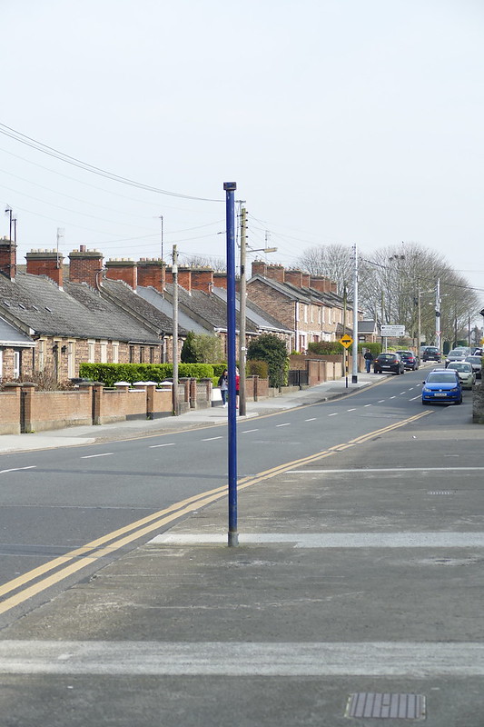
    Bus Stop Of The Month returns after an 18 month hiatus, with a bit of a mystery. Two bus stops can be seen here on Luttrellpark Road / Riverwood Road, but at the moment I have no idea if they were ever in use. 

    Looking at the paint on the poles, the base colour seems to be blue, which was introduced in 1998. The top coat is yellow, which was introduced around 2008. During that period the closest bus route to serve these stops was the 37, but it served Diswellstown Road and Carpenterstown Road. Route 239 also served those same roads for a period too. My research has not come up with any routes that may have served these stops, nor am I sure if they even had stop heads ever applied. 

    If anyone has any information, it would be greatly appreciated. But for now, they are a mystery (along with a third headless stop further down the road) 

    26/03/2022


  • Registered Users, Registered Users 2 Posts: 13,239 ✭✭✭✭Losty Dublin


    Chances are that they were intended for the 239 at some point; that or else they were inadvertently placed there by confused workmen.

    Incidentally, here's some scribing on the 239 and her many sister routes.

    http://www.dublinbusstuff.com/BlanchRoutes/BlanchCentreRoutes.html


  • Registered Users, Registered Users 2 Posts: 3,046 ✭✭✭Csalem


    This month we have a bus stop that has had a number of routes pass by it (including one that still does) but am unsure as to which ones actually stopped there. The stop is located in Edenmore, on Tonlegee Avenue beside Cameron Park. Over the years, various bus routes have used all four roads around the park. The current 27A uses Tonlegee Drive, Tonlegee Avenue and Glenwood Road, as did the 42A and 42B before it. Route 28 also used these roads and used to terminate on Glenwood Road. For a brief period after Network Direct changes, new cross-city route 27 also terminated on Glenwood Road, and used all four roads around the park. However, all of these routes passed the bus stop in this photograph on the other side of the road, and therefore did not serve it.

    It is also worth pointing out there is a second disused bus stop in the background, at the front of the white car and beside the two poles. This is after the junction of Glenwood Road, which means it has to have been served by buses using Tonlegee Avenue to access Edenmore Avenue, and therefore buses in the opposite direction probably served the bus stop under discussion here. A number of routes fulfill that criteria. The first one is the 101 which operated between 1986 and 2000. The Network Direct changes that brought the 27 to Edenmore in 2011 also brought the 104 there via Edenmore Avenue and Tonlegee Avenue. This lasted just over six months when the 104 was taken out of Edenmore in 2012. Two other routes that may have also served just this stop for a while were the 27N (which ceased in 2011) and the 29N (which now goes via the Raheny Road). 

    If anyone has anymore information about what served these bus stops, I would love to hear about it.

    Edenmore, 30/04/2022


  • Registered Users, Registered Users 2 Posts: 13,239 ✭✭✭✭Losty Dublin


    Bizarrely there a stop on Tonlegee Avenue, 7463, that doesn't show up on the RTI app even though it's on the route for the 27A.

    I'm wondering aloud if the main one pictured was erected in a poor attempt to run a route down Edenmore Park or Crescent. The second one appears to be a safer and less intrusive location anyway.


  • Registered Users, Registered Users 2 Posts: 343 ✭✭TranslatorPS


    7463 is in an interesting numbering position: the previous two stops are around the shopping centre in southern Greystones (on the 84/X), 7460 is in Citywest on the 65B/77A, and the entire 745x lot is random locations around the city, almost indicating random stops that should have been in a sequence but were forgotten and added later - what's more, the next 746x is 7469 in Raheny on the 130. All the more interesting considering that all the new additions due to the first two Phases of BC were in the 73xx range.


  • Registered Users, Registered Users 2 Posts: 343 ✭✭TranslatorPS


    I realized it too late, however in the previous post I stated, "All the more interesting considering that all the new additions due to the first two Phases of BC were in the 73xx range." That's not the case obviously, new BC stops are in the 77xx range. Apologies for that.


  • Advertisement
  • Registered Users, Registered Users 2 Posts: 3,046 ✭✭✭Csalem


    This month we are breaking the format of this series, by showcasing an active bus stop. But it does contain a relic of the past that showcases the history of the bus services in Dublin. 

    Stop 128 is located on Glasnevin Avenue in north Dublin. When this picture was taken it was served by Go-Ahead Ireland route 17A from Kilbarrack to the Blanchardstown Centre. Since the 29th May 2022, it has been served by Dublin Bus route N4 from the Point Village to the Blanchardstown Centre. 

    The main point of interest on this shelter is the CitySwift branded glass. CitySwift was introduced into the Dublin Bus network in 1993 with route 39 to Blanchardstown. The idea was to introduce high-frequency services on key routes. It soon spread around the city to key routes such as the 13/A, 51B, 46A, 77 etc. As part of the route transformation, buses were in a special livery and bus stops and bus shelters were painted blue, with the latter receiving orange seating and branded glazing. However this stop on Glasnevin Avenue was not on one of the CitySwift routes, nor did it receive the full CitySwift treatment by being painted blue. More than likely the bus shelter received these glass panels by mistake as replacement for other panels at some point prior to 2009 (the furthest back Google Streetview goes). It is also the last shelter to still have the CItySwift branded glazing in 2022.

    14/05/2022


  • Registered Users, Registered Users 2 Posts: 1,206 ✭✭✭mikeybhoy


    Speaking of outdated adverts I remember being on a Donnybrook AX circa 2017/18 that still had adverts for the Ryder Cup from 2006.


  • Registered Users, Registered Users 2 Posts: 343 ✭✭TranslatorPS


    When Harristown got some of the 320-series AVs when the DCU Universals started (31D/42D/70D) back in 2016, I eventually got one on the 17A still carrying simplified route diagrams - with stages marked out! - for the Fleet Street-terminating 46A :D


  • Registered Users, Registered Users 2 Posts: 3,046 ✭✭✭Csalem


    This month we are going to west Dublin and stop 6356 on Cloverhill Road (although Google Maps calls in Palmerstown Way). This stop had a short service life, being put in for Xpresso route 79X. This route started in December 2007, running from Neilstown Road to Bachelor's Walk, via Cherry Orchard, Ballyfermot and Heuston Station. The route had one departure in the morning and only operated in one direction. The route only lasted until April 2009 when it was withdrawn, along with other low-usage routes, as part of cutbacks due to the recession. 

    This stop served the Palmerstown Woods housing estate, and although no bus route has used this stop during the last 13 years, it may be about to gain a new lease of life. Under the Bus Connects plans, new route 60 is due to serve this road as it operates from Red Cow Luas to city centre via Clondalkin, Cherry Orchard and Ballyfermot. Although, when that route starts, this stop will probably be replaced by a new TFI pole instead. Also, the 60 will be much more frequent than 79X, will operate all day and in both directions.

    02/07/2022


  • Registered Users, Registered Users 2 Posts: 1,439 ✭✭✭StreetLight


  • Advertisement
  • Registered Users, Registered Users 2 Posts: 3,046 ✭✭✭Csalem


    This month we are going to Wellmount Road in Finglas. There are two poles in the picture, one in the foreground without a head, and one in the background that still has its head /9stop number 1591). The headless stop is the one no longer in use, though stop 1591 only advertises a route that no longer runs, rather than the route that still serves it. 

    Throughout their operational life, both stops were predominately served by the 40A, which at the end ran from the city centre to Charlestown via Finglas. This is the route that still appears on the head of stop 1591. The 40A ceased to operate in November 2011 when it was merged into route 40 under Network Direct. It started running in 1932, and at various points had its terminus in Finglas on Cappagh Road, Finglas Place, and St Margaret's Road before moving to Charlestown.

    It is the 40 that still serves stop 1591, but only at the weekend and only the first two departures from Charlestown on Saturday morning and the the first departure on Sunday morning. This route operates via St Margaret’s Road, Plunkett Avenue to Cardiffsbridge Road, then Dunsink Avenue, Wellmount Road, Finglas Road (N2), Phibsboro, Western Way, Mountjoy Square, O’Connell Street to Liffey Valley. Therefore this part of Wellmount Road in Finglas is only served three times a week, in one direction.

    06/08/2022


  • Registered Users, Registered Users 2 Posts: 3,046 ✭✭✭Csalem


    This month we are going down to Dublin Dockland's, and to a bus stop that has been out of service longer than it was in service. Although, to be technically accurate, the stop and the bus route that serve it are more suspended rather than removed from the network. Stop 7705 on Sheriff Street Upper is the terminus for route 53A. This bus route started on the 8th July 2019, and operated hourly between the peaks, Monday to Friday. It was a short route, running from Talbot Street to Sheriff Street via Summerhill, and had a maximum journey time of 15 minutes. When the Covid-19 pandemic hit in early-2020 a number of lightly-used routes were suspended including the 53A which has not run since the 8th June 2020.

    The route is still suspended, as the timetable is still on the Dublin Bus website with a note saying it will not operate "until further notice". Under Bus Connects the route is due to be replaced by the L91, so it remains to be seen if the 53A will ever return or will this stop be next used by the L91 (in which case this pole will probably be replaced by a new TFI one first). 

    04/09/2022


  • Registered Users Posts: 934 ✭✭✭d51984


    Was thinking about this thread yesterday. Theres a bus stop on the Priorswood road with a 3 piece leather suite at it!

    Its a disgrace Joe!


  • Registered Users Posts: 115 ✭✭topdecko


    This is the best thing i have seen on Boards.ie.


  • Registered Users Posts: 685 ✭✭✭TallGlass2


    Spotted this in Ballymun on Longdale Terrace, no idea what route it previously was however.


  • Registered Users, Registered Users 2 Posts: 3,046 ✭✭✭Csalem


    I suspect it was on one of the variations on the 13. Must add this one to my list of stops to record. Nice that it is still blue.


  • Registered Users, Registered Users 2 Posts: 3,046 ✭✭✭Csalem


    This month we are visiting bus stop 7402 on Lower Gardiner Street. 

    Like the previous entry in this series, this bus stop was served by route 53A, and still has a timetable on it for that route. The 53A started on the 8th July 2019, and operated hourly between the peaks, Monday to Friday. It was a short route, running from Talbot Street to Sheriff Street via Summerhill, and had a maximum journey time of 15 minutes. When the Covid-19 pandemic hit in early-2020 a number of lightly-used routes were suspended including the 53A which has not run since the 8th June 2020. The route is still suspended, as the timetable is still on the Dublin Bus website with a note saying it will not operate "until further notice". 

    This bus stop was also served by Airlink route 747 on its way to Dublin Airport. This express bus route to the airport was also suspended during the outbreak of Covid-19 in early-2020. However, it never returned and was officially cancelled during August 2021. CIE, and later Dublin Bus, had run this service between Dublin Airport and the city centre in various forms for many decades. This stop on Gardiner Street had only been used by the 747 in the last decade or so of operation, when the route was sent on a convoluted journey between Heuston Station and Dublin Port Tunnel in order to serve hotels in the city centre.

    13/11/2022


  • Registered Users, Registered Users 2 Posts: 3,046 ✭✭✭Csalem


    This month we are going to a fully fitted out, new bus stop / shelter that was never used. This stop is located on Longfield Road, within The Coast development in Baldoyle. In the early-2000s the land on both sides of the Dublin to Belfast railway line at Donaghmede / Baldoyle was developed as new communities to accommodate the growing city population. The Dublin City Council lands on the western side became Clongriffin (which also gave its name to the new railway station) while The Coast on eastern side fell under Fingal County Council jurisdiction. However, both sides were due to be connected by a new public transport bridge at the railway station. The bridge was built and the ramp up from the western side was complete, but the corresponding ramp on the eastern side was not. The new developments were planned to be served by buses too, which would have used the new bridge and served this stop. New route 128 from Rathmines started in 2007 and terminated at Clongriffin station, and it has been suggested it would have been extended over the bridge to serve the stop here and continue on to Baldoyle. It was also suggested the 29A would have been extended from Donaghemde to Baldoyle via Clongriffin and The Coast. It was extended in 2012, but via Grange Road and not Clongriffin. It has also been speculated that the 32B, which went to nearby Abbey Park, would have been extended to here, but that route was also cancelled in 2012. In 2021 the 29A became the H1 under Bus Connects and it is planned to terminate at Clongriffin Station, but will be extended from the Baldoyle end and go via Red Arches. So this stop, and the associated bus lane, will remain unserved. The H1 does serve a bus stop near the junction of Longfield Road and Grange Road.

    At least the ad agency is getting some benefit from it. 

    10/12/2022


  • Registered Users, Registered Users 2 Posts: 3,046 ✭✭✭Csalem


    This month we are going to a bus stop on Torquay Road, near the junction with Leopardstown Road. For many years this road was served by route 86. This bus route started as a replacement for the Harcourt Street railway line which closed on the 31st December 1958. Originally running between the city centre and Bray via Dundrum and Foxrock, it was cut back around 1971 to Cabinteely. Around 2005 the route was cut back further to only run between Shankill and Sandyford Industrial Estate, in one direction only in the morning. The route last ran on 17th April 2009. 

    Leopardstown Road in the background is still served by route 114 running between Ticknock and Blackrock, and Foxrock Village is served by the infrequent 63A running between Kilternan and Dun Laoghaire. 

    06/01/2023


  • Registered Users, Registered Users 2 Posts: 3,046 ✭✭✭Csalem


    This month for Bus Stop Of The Month we are going to Maynooth in County Kildare. Stop 6209 is an inbound stop located on Meadowbrook Road, near the junction with the Meadowbrook Link Road (which also has two abandoned bus stops on it). From research it seems these stops may have been served by the morning route 66X departure from Cluain Aoibhinn. This route started around 2000 and used to go via Parson Street, Main Street and Straffan Road to access the N4. Around late-2006 / early-2007 work took place to rebuild the bridge over the canal and railway on Parson Street and the 66X was diverted via Meadowbrook Road and Meadowbrook Link Road and going up Straffan Road to do a u-turn at the then 67A terminus to head back to the N4. This diversion then became permanent, although it should be noted there was never a corresponding return journey in the evenings from Dublin. In 2010 Network Direct arrived to Maynooth and this 66X departure was removed from the timetable. In the planning phase for Network Direct there was a proposal to run the 66 via Maynooth Main Street, Parson Street, Meadowbrook Road, Meadowbrook Link Road and terminate at the then 67A terminus on Straffan Road at the railway station, but this didn't happen. 

    Since then Bus Connects came along in 2021 and the 66 became the C3 and the 67 became the C4, but the Meadowbrook area is still unserved. Parson Street (and the nearby Newtown Road) have been served by route 139 since 2018, which runs between Blanchardstown and Naas. 

    28/01/2023


  • Advertisement
Advertisement