Advertisement
If you have a new account but are having problems posting or verifying your account, please email us on hello@boards.ie for help. Thanks :)
Hello all! Please ensure that you are posting a new thread or question in the appropriate forum. The Feedback forum is overwhelmed with questions that are having to be moved elsewhere. If you need help to verify your account contact hello@boards.ie
The Sudden Stratospheric Warming 2011/2012
Options
Comments
-
Join Date:Posts: 6779
We are currently in the middle of a forecast period with the upper to mid stratosphere undertaking a remarkable warming up when we compare to early winter.
I have to say that I have kept quiet on the model thread recently, as I have found the daily difference of stratospheric modeling inconsistent with being able to give a reasoned tropospheric forecast.
Overall the picture is very promising but when analysing in more detail there are areas of the forecast that could be better - but there is still change for that.
The GFS gives an easier, more straightforward forecast to explain. Here we see the forecast upper warming completely reverse the vortex at the top of the stratosphere (1hPa).
ECM close to agreement here and mean zonal mean wind reversal is forecast on both.
Moving down the stratosphere the forecast displacement seen on the vortex differs. At 10 hPa the ECM suggests that the vortex is trying to reclaim pole position - whereas the GFS is holding the vortex at bay - both suggest further warming
I think the bif=g difference here may be due to different modelling of the E-P flux - suspect that the GFS forecast (if we could see it ) is less equatorwards than the ECM and that could be critical for downwards polar propagation.
As a result the forecast warming at 30 hPa (GFS) looks the most promising that we have seen yet and more central than the ECM.
So looking towards the troposphere, I feel that there is very little to be gained looking further than 6-8 days ahead.
If one scrolls down the folowing link it is possible to see a section of the vortex become sectioned east of Scandinavia and head south before weakening.
http://wekuw.met.fu-...ast=all&lng=eng
It leaves an opening in this process for height rises to develop over Scandinavia from days 6-7 and that is what is being modeled. I suspect how far south this segment of vortex is critical - the further south it reaches the better chance of tropospheric undercutting.
GFS is similar but with differences in keeping a large segment of vortex over the Canadian Arctic. Promising as the weakend vortex has split allowing those rare Svalbard height rises.
I now feel that a great opportunity to get winter started is coming into a closer timeframe and hopefully patience will be rewarded.
c0 -
Join Date:Posts: 6779
Just scrolling through ECM and GFS forecasts 10hPa through 70hPa does appear to suggest some downwelling of the warming currently taking place. I think the remants of our first warming wave are still around 100hPa and this second wave appears to catch up in the extended timeframe. From around day 10 the 30hPa layers and below seem to take on a dramatic shift with the vortex being squeezed into a sausage shape aligned across the Pole. Definitely something going on there.
GFS continues to toy with this idea of a third warming although tendency of late has been to deflect this away from the pole somewhat.
With angular momentum likely to slide (a good thing for cold tropospherically), we aren't likely to see any significant mountain torques in the next few weeks until early Feb when I suspect a big MJO wave passing through the Indian Ocean will trigger off another round of warmings in the stratosphere. This is only speculation, but I suspect a bit of cooling at the top layer wouldn't be a bad thing in helping along the warming lower down.0 -
Join Date:Posts: 6779
I expect forecast to be a bit tricky in the 8 to 10 day range as the displacement of the stratospheric vortex might or might not end. Perhaps I can show in charts what I mean about the end of the displacement.
Notice how in this chart the blue low area is centered towards the UK. Now a couple of days later the forecast chart looks like this.
The blue low area is shifting back towards the pole, or perhaps splitting. Not quite sure whether this evolution is right or whether we have a different kind of warming. The following chart suggest perhaps a split at the lowest level.
Notice how the warmer air at the lowest level of the straophere on this chart is making its way round towards the UK from the US. That to me suggests a higher risk of high pressure in the atlantic and towards the UK. The following stratosphere vorticity chart out at tend days suggests a negative AO.
So interpretting this and putting any sort of confidence on things is difficult. Because of the potential transition I would give a low confidence on my thougths which are :
Perhaps ironically the end of the stratospheric warming is giving us a chance of colder weather. Because the colder weather is not really stratospheric warming induced the chance of sustained blocking is limited. My best guess is that we will get a chance at some northerly weather followed by an easterly period. At this point without further changes to the stratosphere I cannot see the cold spell lasting more than a week.
So do we get another warming or not and here I am trending towards saying Yes based on the fact that we should have had some wave breaking over Greenland recently. Charts perhaps give hints but its too early to tell.
Still some variation on Windy and mostly wet will be nice however long it lasts (probably going to regret saying that, I usually do). The old Maxim that whatever the east coast of the US gets, we get soon after might actually hold true for once in the 8 -16 day range, so perhaps worth watching their weather for once. Beyond that I would be guessing, but I think another cold spell in February is likely.
Some feed back on the above post
I just don't trust the ECM 8-10 day forecasts. The T+240 chart, that looks like a scream mask, looks to send the vortex back to a more central position too quickly and I suspect it may be because of the difficulties in modeling a vortex under strain at this point.
Will be interesting to see tomorrows update.
__________________________________
The heights that we are seeing on the synoptic charts that are building across the Arctic on the eastern side from
the bering sea area are surely a response to the warmings we have and are seeing. I know lower down in the
stratosphere they show up as lower pressure but maybe as they down well from 10 and 30 hpa into the
tropopause they are being displaced further west.
___________________________________
I suspect that they are - the feedback from before the New Year. It was always going to be a case of when the ball started rolling it would carry on gathering momentum.0 -
Very interesting read ! THanks!0
-
Join Date:Posts: 6779
Morning all... Just a few thoughts from me on the current situation and unfortunately from my analysis and understanding the outcome is leaning more towards bad news than good news, but it could be somewhere 'down the middle'.
Starting with the following chart however, a piece of good news and of actual observation of the temperature at 30hPa over the N Pole;
http://ds.data.jma.go.jp...RAT/html_e/pole30_n.html
For the first time this winter the temperature has finally risen above the climate average and clealry when compared with late December and the majority of early January it is clearly quite a rise in temperature, but still nothing really 'major'. Clearly what has to be acknowledged here is that some 'factor' has caused this warming and clearly that has been discussed in depth in recent days and weeks and clearly that is primarily down to discussed warming within the stratosphere that has taken place over the last 7 to 14 days. So the current state of affairs is that compared with December the strat is warmer, not majorly so, but it is clearly warmer and without question that has and is having an affect on the PV compared with conditions evident through December and also into early January.
Now some general analysis and overall I'm not seeing a huge amount of positives at the moment. Clearly the other thing to note is that like any forecast, the information below is subject to change, to either a better scenario or worse etc.
http://wekuw.met.fu-berl...forecast=all&lng=eng
If you follow through the series of charts on that linke, despite evident warming at the 10hPa the main vortex becomes relocated over the polar region once again now by day 9 and day 10, with the centre almost directly over the N Pole at the 240hr, not an ideal situation.
http://wekuw.met.fu-berl...ll&var=u&lng=eng
The zonal wind, whilst reversing and becoming negative near day 3 and day 4, by the latter half of the forecast period actually goes back the other way now, particularly above 10hPa and near 60N to 70N, signal a renewed threat that perhaps the zonal wind will strengthen.
http://wekuw.met.fu-berl...ar=ta1&lng=eng#fig11
Wave 1 temperature prediction is also on the wane as well towards the back end of the forecast period, further negative signs.
http://wekuw.met.fu-berl...&alert=1&lng=eng
The above link does highlight things very well also. Notice that whilst the 1hPa ZW is near 0, the more important 10hPa and 30hPa values are forecast to rise towards the middle and latter half of January. Clearly they are lower than throughout December, but there is no sign of any reversal of any kind. The other important factor as well is that the EPV (bottom image) is poor, the EP vectors a forecast to drop away now and no only that there is little sign for any poleward direction to the EP flux and they continue to be on an angle.
http://wekuw.met.fu-berl...&alert=1&lng=eng
In according with the the Wave 1 temp prediction above you can see on the above imagery as well, that Wave 1 in particularly is forecast to decline through the forecast period as well. In sort of comparison mind, the GFS in particular looks very promising in terms of temperature rises over the polar at the 10hPa level at 240hr;
http://www.cpc.ncep.noaa...iles/gfs_t10_nh_f240.gif
So in my opinion the the latest forecast data isn't as promising as to was say 5 to 7 days ago. There have been factors involved which have helped to destabilise the PV compared to what it was like in December, that goes without question, but equally the latest forecast data does seem to suggest a less than favourable environment to really disrupt the PV within the medium to long term.
Clearly forecast data can and does change, but those hoping for a significant SWW event within the near future will likely be dissapointed as I can't see it happenning.
Matt.
Matthew Hugo BSc(Hons), FRMetS
Meteorologist
Weather Commerce Ltd
On Twitter @MattHugo810 -
Advertisement
-
As like the last page but an advancement on chart,
Bang, back of the net??
Has Messi just scored
Fair reach down shown now into the Trop,gotta have an influence. Here's hoping the snowballs come to this land and not a close call.
Also to add this chart means that westerly winds are dramatically reduced as the easterly anomaly from warming has reached down0 -
Redsunset the areas ive circled, if im reading it right, a warming right down through to sea level?

Uploaded with ImageShack.us0 -
No thats the Anomaly Zonal winds. Also 1000ha is not sea level
Heres the warming chart
Nothing guaranteed here remember but helps chances0 -
Sorry mate, got carried away there...:D:rolleyes:0
-
It would be interesting to see how February panned out in previous years where there has been a similar type of warming- this is years where the epf has not played ball0
-
Advertisement
-
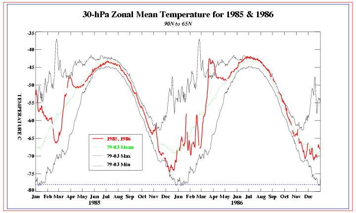
Closest match to now would have to be Feb 86
Just wanna say that this is not a given as not everything matches perfect. Could end up being a heatwave just as easily in Feb
Warming in Jan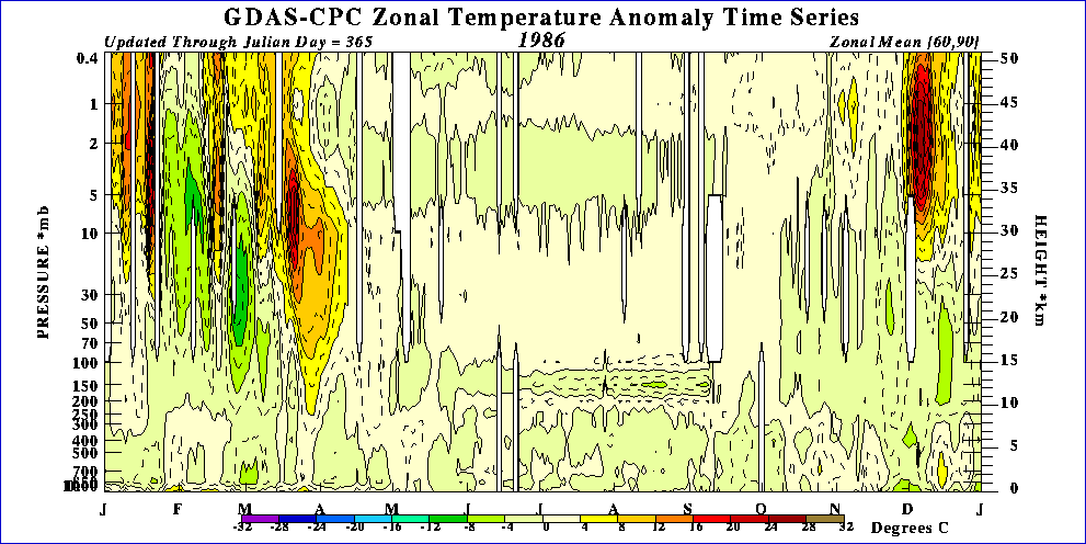
 0
0 -
Join Date:Posts: 6779
Matthew Hugo @MattHugo81 1h Reply Retweet Favorite · Open
Not good...mean zonal wind set to increase above 20 to 30hPa now longer term from the ECM = renewed support for +NAO/Atlantic weather...0 -
As I showed above in Zonal wind anomaly chart westerly winds were decreasing through the Strat down to the Trop.
GP has posted this on Netweather and gives more detail on what he thinks.
A GLIMMER OF HOPE? from Glacier Point on Netweather.
Part of my thinking here is that the negative zonal winds making their way down from the stratosphere (or the weakening in westerlies) will further impart a fall in angular momentum.
With regard to the stratosphere, the current cross section shows an impressive atmospheric response through the tropopause which has effectively halted the strong cold vortex event. There is more of this to come, several more days at least including a sharp response at the 30 hPa layer in the last few days so expect this plot to look even more impressive, and likely to favour a negative AO.
During the programmed transition out of the first half of the winter and cold vortex event, the GFS ensembles were too bullish in bringing the negative AO. However, both GEFS and parallel GEFS are now going for a negative AO and also a negative NAO to develop (interestingly the Canadian model is also onboard with this whereas during the last week it wasn't interested in it).


Long range model tools are in good agreement depicting a strongly amplified pattern over North America and remnant polar vortex centred over Alaska. In the Atlantic, the models agree on a shallow trough over or just west of the UK and developing ridge across the top extending from Siberia across Svalbard towards northern Greenland. Pictured here CPC 8-14 day and ECM ensemble mean for day 10:

I would good for this as a good guide for the next 10 days. Unsettled with temperatures below or slightly below average although not spectacularly so, and the potential for an easterly feed not totally ruled out.
Beyond this, ECM extended ensembles suggest little change. Not so sure of this myself. If the -AO/-NAO regime develops, it should only be a matter of time before colder air filters into the mix, probably from the east or north-east.
A quick word for any in the 'well this is just more of the same...' brigade. No chance. We were staring into the abyss with that deeply +NAO / +AO regime. That has now gone. Why ?0 -
Join Date:Posts: 6779
Well - good and bad news today.
The good news is that we are almost at that technical SSW and if it was measured at 58N then it is forecast to be achieved as shown below. The mean zonal mean winds drop to less than 2 m/s at 10hpa and 60N.
Not that I think it makes too much difference whether or not we have a technical SSW at this stage ( one for the history books) - the affect of the warming is going to be the same now.
In previous events we have seen the negative mean zonal winds drop down the stratosphere close to the North Pole (or rise up close to the pole). This event is different in that the negative mean zonal winds are being diverted equatorwards - probably as a result of the unfavorable E-P flux.
How this effects the mean zonal winds in the lower stratosphere and troposphere around polar regions remains to be seen. Presently it looks like the reformation of the polar vortex in the upper stratosphere could be favorable to a negative AO in the lower stratosphere with an area of weakened vorticity situated here.
However looking ahead to the next 6 weeks it is very unlikely that we will return to the vortex Intensification conditions seen earlier this winter and that we are likely to enter a period that is more conducive to high latitude blocking, the such of which we are seeing on the other side of the hemisphere currently.
The not so good news involves the short to medium term forecasts at the lower level of the stratosphere. We are seeing both the ECM and GFS agree at the 100 hPa level that the polar vortex is shifting back towards Greenland. It is weakened but will still be enough to stop blocking occurring there in the medium term - it certainly needs monitoring.0 -
Join Date:Posts: 6779
Today's update in full.
So far this winter we have seen an extremely cold stratosphere dominate proceedings. This has led to a protracted period of zonality caused by the vortex intensification that resulted from the cold.
Around Christmas time we had the first signs that things would change and sure enough just under a month later the changes are working there way through to the tropospheric output. These changes resulted from a series of remote wave breaking events at the top of the stratosphere introducing warmer air that has taken time as it has propagated nodally down the stratosphere.
We are now at a situation where currently we are seeing a warming into the core of the vortex far closer to the troposphere than encountered so far this winter - at the 30 hPa level.
The upper warnings so far have had the net effect of dragging the mean zonal negative winds equator wards which has somewhat inhibited the effect felt in northern latitudes tropospherically with the stratospheric polar vortex reducing but still present.
However this could change with the positioning of the next warming at 30 hPa:
And we are likely to see a far greater lower negative anomaly of mean zonal winds by the end of the month:
So we can compare the forecast for the mean zonal winds and look to see that the polar vortex has reduced dramatically in intensity as we are not too far away from a technical SSW.
So what does this mean for us on the ground?
Well to get a better idea we need to be looking at the charts for the lowest part of the stratosphere at around 100 hPa
Both the GFS and ECM are modelling a weaker less stable vortex that is constantly on the shift. In fact there has been some suggestions of splitting by day 10
If this occurs then any Siberian vortex could exert some pressure on the Siberian High pushing the Russian high further west towards the UK followed by a Greenland pressure rise after that. This also fits in nicely with the GWO rather than working against this.
The troposphere models are coming up with these scenarios. Finally, the slow drip feed of the stratospheric change into the troposphere is coming close to bearing fruit.
c0 -
If we look at the Zonal wind anomaly we see the easterly influence lifting back up
Unlike what the guys over on Netweather were anticipating.
Now this can really only mean the PV will regain strength however I don't see it getting the upper hand just yet as another warming should put a stop to that.
I think heights will build to our North for bout a week in early Feb and hopefully we see something from that.
It does not look too wonderful at the moment but The minor PV recharge might actually help with blocking.0 -
Also this warming really is coming down and so that is why early Feb could be our only shot. 0
-
pistolpetes11 wrote: »Today's update in full.
Around Christmas time we had the first signs that things would change and sure enough just under a month later the changes are working there way through to the tropospheric output. These changes resulted from a series of remote wave breaking events at the top of the stratosphere introducing warmer air that has taken time as it has propagated nodally down the stratosphere.
c
So if i understand this correctly, last winter, after the major warming, it took about a month for the cooling stratosphere to eventually have an effect on the troposphere. We saw this with the eventual change to milder weather late on Christmas day. Although the stratospheric warming of November 2010 seems to have been a major warming at all levels, unlike this current warming where the polar vortex isn't completely destroyed at the upper level of the stratosphere, so the polar vortex took longer to reorganise itself. That won't seemingly be the case this time judging by redsunsets and su campu's comment. Still even just a week of colder weather would be fine, after what we've had so far.0 -
Last year before the PV had the chance to even get going the November warming put a spanner in the works. In last years thread I was curious as to why all the Northern blocking as we were in a west QBO and this is what GP had to say bout it.
==========================================================
It's worth considering the presence of downwelling and upwelling waves through the stratosphere and upper troposphere tied into the state of the QBO as a having a strong influence on lagged impact of anywarming or sustained cooling.
QBO 'switches' from east to to west and vice versa generate waves. These waves tend to have a periodicity of 3 months and are associated with anomalous upwelling (warming) waves which are reflected back down through the stratosphere and troposphere and also take around 3 months. Upwellng and downwelling waves are particulalry identified during transitions from east to west phase QBO during the autumn and winter months. West phases tend to start with downwelling waves which propogate and are reflected back upwards 3 months later. These can lead to 3 months where there is a noticeable 'trace' in zonal wind anomalies. The transition from an east to west based QBO can provide optimal conditions for blocking through -ve zonal wind anomalies, peaking at the transition point.
We can see the trace of upwelling and downwelling this autumn, the transition to a west QBO taking place during August but not manifesting iteself in the polar atmosphere until late September.
The blocking signal (enhanced -ve zonal wind anomalies) peaked during October and I suspect the cold outbreak that took place then was heavily influenced by this although the blocking signal at 500 hPa and above has remained favourable since October. Looking at the periodicity, the blocking signal should come under pressure at 200hPa around the turn of the year, and then progressively weaken to a minimum in February and March as the downwelling of +ve zonal winds (weakest upwelling waves) reaches its peak intensity. This underlines the extremely long time scales for stratospheric events to impact the troposhere.
During Feb 2009, the west QBO was well establihsed and downwelling waves had penetrated low down into the troposhere with +ve zonal wind anomalies prevelent.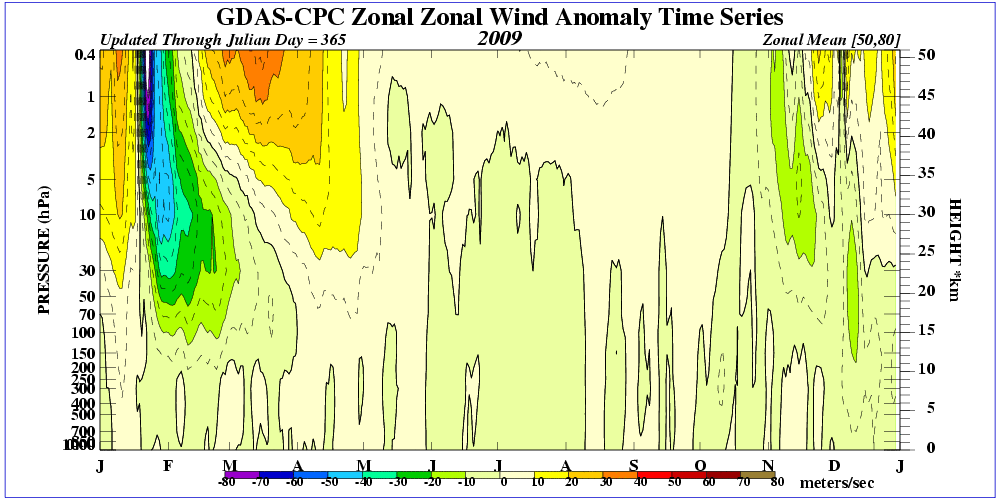
The warming event (downwelling easterly winds) had difficulty in manifesting in widescale blocking becauase of the the tropospheric - stratospheric coupling for west winds due to La Nina and downwelling waves. It literally had to fight its way down and work against the grain. Any warming event in February this year will likely have a similar task.
Stratospheric impacts on the troposhere during November and December are less probelamtic because +ve zonal wind anomalies have yet to stir sufficiently to interfer with any other signal
=========================================================
This all seems very plausible to me0 -
Join Date:Posts: 6779
Great GFS stratospheric charts this evening.
We are very close to achieving a technical SSW.
But look at the stretch on the vortex here at T+240 and 100 hPa
And look at the ozone levels!
What a contrast to a year ago!
I am already thinking that this will give us a good starting base for next winter!0 -
Advertisement
-
Last year before the PV had the chance to even get going the November warming put a spanner in the works. In last years thread I was curious as to why all the Northern blocking as we were in a west QBO and this is what GP had to say bout it.
==========================================================
It's worth considering the presence of downwelling and upwelling waves through the stratosphere and upper troposphere tied into the state of the QBO as a having a strong influence on lagged impact of anywarming or sustained cooling.
QBO 'switches' from east to to west and vice versa generate waves. These waves tend to have a periodicity of 3 months and are associated with anomalous upwelling (warming) waves which are reflected back down through the stratosphere and troposphere and also take around 3 months. Upwellng and downwelling waves are particulalry identified during transitions from east to west phase QBO during the autumn and winter months. West phases tend to start with downwelling waves which propogate and are reflected back upwards 3 months later. These can lead to 3 months where there is a noticeable 'trace' in zonal wind anomalies. The transition from an east to west based QBO can provide optimal conditions for blocking through -ve zonal wind anomalies, peaking at the transition point.
We can see the trace of upwelling and downwelling this autumn, the transition to a west QBO taking place during August but not manifesting iteself in the polar atmosphere until late September.
The blocking signal (enhanced -ve zonal wind anomalies) peaked during October and I suspect the cold outbreak that took place then was heavily influenced by this although the blocking signal at 500 hPa and above has remained favourable since October. Looking at the periodicity, the blocking signal should come under pressure at 200hPa around the turn of the year, and then progressively weaken to a minimum in February and March as the downwelling of +ve zonal winds (weakest upwelling waves) reaches its peak intensity. This underlines the extremely long time scales for stratospheric events to impact the troposhere.
During Feb 2009, the west QBO was well establihsed and downwelling waves had penetrated low down into the troposhere with +ve zonal wind anomalies prevelent.
The warming event (downwelling easterly winds) had difficulty in manifesting in widescale blocking becauase of the the tropospheric - stratospheric coupling for west winds due to La Nina and downwelling waves. It literally had to fight its way down and work against the grain. Any warming event in February this year will likely have a similar task.
Stratospheric impacts on the troposhere during November and December are less probelamtic because +ve zonal wind anomalies have yet to stir sufficiently to interfer with any other signal
=========================================================
This all seems very plausible to me
So would it have been easier to get the feb 2009 event in an el nino winter? is there an even split between warming events in el nino and la nina winters?0 -
QBO
I've colour coded the east and west phases below for easier reading.
Blue = easterly Red = westerly
2008 -12.42 -4.70 2.19 6.43 11.53 13.45 13.27 11.63 11.60 11.05 9.13 10.46
2009 10.71 12.33 11.44 9.11 1.56 -5.47 -12.21 -14.45 -13.81 -11.69 -13.83 -15.57
2010 -16.02 -16.98 -19.68 -23.57 -26.28 -25.05 -9.84 1.45 6.58 10.83 12.16 10.97
2011 9.18 10.05 10.44 10.71 10.02 3.90 0.44 -0.49 -2.30 -3.05 -9.09 -16.25
The QBO for Feb 09 was very much westerly so transition periods could not influence matters.
Where as last Nov/Dec cold spells were in that transition phase from east to west and so it took till New Year for the waves to take effect in preventing blocking.
Peak blocking was period prior to this.
As for the La nina hindering things,well maybe but remember I showed this chart for how similar conditions with a weak central based La Nina Like what occurred the previous autumn, WITH a Strat warming in the winter led to this in analogues
Certainly seems like a perfect match at the moment:)
Here's a good pdf
http://www.columbia.edu/~lmp/paps/butler+polvani-GRL-2011.pdf
RESULT
Over the period 1958–2010, a total of 34 major mid‐winter SSWs were identified in the NCEP‐NCAR reanalysis,listed in Table 1 (first column) together with the corresponding ENSO phase (Table 1, second column). Note that all events prior to 2003 are identical to the ones reported by Charlton and Polvani [2007, Table 1], which is extended to the year 2010 here. Of these 34 events, only 7 occur during ENSO‐neutral winters, confirming the widely held belief that ENSO enhances stratospheric variability. Of the remaining 27, however, only 13 have occurred during El Niño winters; the other 14 have occurred during La Niña
winters. This is the key finding of our study: that SSWs are as common during La Niña events as they are during El Niño events. This finding does not significantly change if SSWs are examined in the European Centre for Medium‐Range Weather Forecasts (ECMWF) ERA‐40/ERA‐interim reanalysis [Uppala et al., 2005]: in that case, from 1958–2010, out of 37 total warmings, there are 15 SSWs during El Niño winters, 14 SSWs during La Niña winters, and
8 SSWs during ENSO‐neutral winters0 -
Join Date:Posts: 6779
Latest Update.
We still have encouraging signs filtering down from the stratosphere both for the short term and longer term outlooks.
Let's start long term. It looks like the upper strat forecasts are indicating another round of warming in around 10 days time. This is supported by both the GFS and ECM. Remember that the stratosphere hash't regained it's former strength yet so theoretically we shouldn't need as strong a warming to tip the scales this time.
This seems to be initiated by an increase in wave number two activity - the vortex splitting wave , perhaps being set off by an expected strong mountain torque. This will be useful further down the line - if the cold spell kicks off, a split could aid in prolonging this type of scenario. We see a split being forecast by the GFS at T+240 and 30 hPa.
So, carrying on we need to look at the shorter term.
The possibility of a Scandi block is well supported by the lower stratospheric charts. The only uncertainty remains in how much energy can get under the block to keep it sustained for the long term.
At T+168 the 100 hPa chart is very favourable for there being enough energy.
The T+240 has changed a lot since yesterdays run so we will need to wait until tomorrow for that.
The GFS 10 Day chart suggests a healthy Svalbard block and is trending towards a major split confirmed by the earlier 30 hPa chart.
Even if the easterly doesn't hit big time I suspect a below average February will be on the cards - maybe even significantly so!0 -
Join Date:Posts: 6779
Briefly, I am seeing the increasing signs in the outputs of Greenland height rises following the initial Scandinavia high. Both the ECM and GFS have had runs suggesting this. I would therefore expect to see either undercutting or amplification downstream in more model solutions from around day 10.
This could lead to a more prolonged cold spell. So for those touting an early end to the cold, beware, another recharge from the north could follow quickly behind.0 -
Join Date:Posts: 6779
Just been having a through look at the stratospheric charts to see if we can get an idea of where we are heading.
Firstly it should be stressed that the polar vortex is very much weakened since the recent warming back in January and that this state is likely to persist through February. We are already seeing high latitude blocking through the extension of the Siberian high, and the continued weakened state of the stratosphere is likely to persist and lead to further HLB's developing over the northern hemisphere.
Those who continually suggest that we are about to see a return to the increased strength of polar vortex witnessed during December are likely to be not looking at the bigger picture. The odd run may suggest more zonal conditions but these are unlikely to verify. Do look at NH charts and don't rely on Atlantic segmented charts.
So, looking at day five we can see when looking at the 100hPa charts why the Atlantic is pushing the block back west. Both the GFS and ECM suggest a trough extending into the north of Greenland temporarily dropping heights to our northwest.
It is from this point on that divergence emerges in the stratospheric profile and this is influencing tropospheric output.
After this point the polar vortex is likely to split due to increased wave number 1 and 2 activity. How this split is modeled will depend on where the remaining segments of polar vortex and increased potential vorticity occur. And also where HLB's are likely to occur.
The split looks likely to occur around the Alaskan region from around day 8. The GFS goes for a straightforward split from Alaska to Siberia leaving an elongated lobe of vortex over Greenland and a likely flatter jet stream over the Atlantic.
This is not what we would like to see!
The ECM solution is more complex, with the Greenland vortex section splitting over Greenland and the Azores high attempting to link up with the Alaskan high.
This is far the more favourable option.
Higher up the stratosphere the increased wave activity is likely to lead to further vortex disturbances. The forecast vortex strength at 30hPa is less than 5m/s and this fits in well with another downwelling of negative mean zonal winds that has just restarted.
Even if the GFS solution is correct I would still think that further along the line that the positioning of the vortex lobes will change, and I would far rather see a very disturbed polar vortex than the extremely strong one that we saw due to the cold stratospheric start to winter.0 -
Well, it seems the absence of local wave breaking and the eliassen palm flux not going poleward were decisive factors this year, despite the ecm 32 dayer suggesting otherwise in early February. Also the polar vortex being as strong as it was during December probably didn't help matters!0


Advertisement