Advertisement
If you have a new account but are having problems posting or verifying your account, please email us on hello@boards.ie for help. Thanks :)
Hello all! Please ensure that you are posting a new thread or question in the appropriate forum. The Feedback forum is overwhelmed with questions that are having to be moved elsewhere. If you need help to verify your account contact hello@boards.ie

Interesting Maps

Options
16768707273236

Comments

  • Posts: 25,611 ✭✭✭✭ [Deleted User]


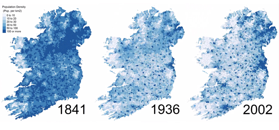
    After a quick Google, I found this:

    Pop-copy.-1841-1936-2002.jpg

    That's mental. I knew the west of the country lost a lot of population but I didn't realise that all the way from Lough Neagh to northern Meath was so densely populated.
    It reminds me of when I'm on a certain old road nearby that I'm fairly sure would've been the main north-south road/path in past centuries. There were big battles in the area as well. The idea of it being an old highway with bandits and the like fascinates me. :pac:


  • Registered Users Posts: 78,278 ✭✭✭✭Victor


    That's mental. I knew the west of the country lost a lot of population but I didn't realise that all the way from Lough Neagh to northern Meath was so densely populated.
    I understand this is somewhat contrived - those areas were only slightly over the 100/km2 number.

    Contrast that with parts of the cities that would have had close to 50,000/km2 at the time.


  • Registered Users Posts: 8,925 ✭✭✭Gregor Samsa


    care to explain it for the idiots who post here?

    The point was that changes involving very small populations can give the impression that the change is greater that it really is.

    A change from one to two of something is a 100% rise.

    A change from 5,000 to 6,000 of something is a 20% rise.

    Looking purely at the percentages, you could be forgiven for thinking that the first situation has changed five times more than the second situation.

    But looking at the raw numbers, you see that the second situation has actually changed a thousand times the first one.

    My take was that the "break in rate" example was merely to illustrate the general point, not a confusion with statistics regarding religion.


  • Registered Users Posts: 441 ✭✭forgottenhills


    That's mental. I knew the west of the country lost a lot of population but I didn't realise that all the way from Lough Neagh to northern Meath was so densely populated.

    The collapse in the populations of counties Cavan, Monaghan, Leitrim, Longford and Roscommon between 1841 and 1991 as indicated on that map above and as shown on the tables here is quite startling.


  • Registered Users Posts: 13,651 ✭✭✭✭josip


    While I understand the point being made about percentages, I don't think it fully explains the original map for North Clare and West Galway.

    https://www.boards.ie/vbulletin/showpost.php?p=115977174&postcount=2044

    There are other, equally sparsely populated areas of the country, Comeraghs/Knockmealdowns/Blackstairs/Bog of Allen that don't show the same pattern.

    Also the areas depicted, although sparsely populated, are large enough that they would surely contain enough people to prevent a few outliers having such a telling impact. There must be an identifiable reason, in the same way that Palatinate names are more common in Limerick.

    I'm thinking that the post Celtic Tiger predominance of holiday homes in those areas, combined with the Sunday April 11th census date, meant that the local population was boosted by godless and other heathens from Dublin on that night.


  • Advertisement
  • Posts: 25,611 ✭✭✭✭ [Deleted User]


    Victor wrote: »
    I understand this is somewhat contrived - those areas were only slightly over the 100/km2 number.

    Contrast that with parts of the cities that would have had close to 50,000/km2 at the time.

    Still though, if you look at West Tyrone and Armagh it didn't just slip below the 100.
    As well as that Louth lost 15% from 1841 to 1851 (and another 15% in the following 10 years). With 2 large towns, one being a garrison town, I assumed it wouldn't have been particularly affected.

    EDIT: A quick google shows Dublin County had its population go from around 372k to 405k in those 10 years. How much of the county or city had a population for 50k per square kilometre at the time?


  • Registered Users Posts: 78,278 ✭✭✭✭Victor


    Still though, if you look at West Tyrone and Armagh it didn't just slip below the 100.
    I was referring to
    from Lough Neagh to northern Meath
    EDIT: A quick google shows Dublin County had its population go from around 372k to 405k in those 10 years. How much of the county or city had a population for 50k per square kilometre at the time?
    These are maps from 1837-1842, available from http://map.geohive.ie/ There are open fields next to Connolly and Pearse Stations, Camden Street and Phibsborough Road. I suspect there wasn't much house building in the 1840s. There was many a family at 8 people to a room at the time.

    540377.jpg

    540378.jpg


  • Registered Users Posts: 8,430 ✭✭✭Markcheese


    Victor wrote: »
    What is a shop?

    Map from 1918.

    540283.JPG

    Nice , you can count the houses around the crossroad that is tallagh ..

    Slava ukraini 🇺🇦


  • Registered Users Posts: 78,278 ✭✭✭✭Victor


    Markcheese wrote: »
    Nice , you can count the houses around the crossroad that is tallagh ..
    At that scale, each black dot likely represents a cluster of building, not an individual house. This is the village in the 1888-1913 era. From http://map.geohive.ie/ - you can zoom in another bit there. By 1970, the population was still only something like 2,500.

    540396.png


  • Posts: 25,611 ✭✭✭✭ [Deleted User]


    Victor wrote: »
    I was referring to
    Do you know where Lough Neagh is?


  • Advertisement
  • Registered Users Posts: 715 ✭✭✭Stihl waters


    After a quick Google, I found this:

    Pop-copy.-1841-1936-2002.jpg

    Thanks, christ that's mental stuff


  • Registered Users Posts: 21,520 ✭✭✭✭Tell me how


    Thanks, christ that's mental stuff

    Aside from the drop off in population, it also highlights the Dublin centric focus of the country and how it is tied to population but when you look at so much of the rest of the country, it would be in everyone's interest if everything was not so heavily focused in one coastal area.


  • Registered Users Posts: 78,278 ✭✭✭✭Victor


    Logainm https://www.logainm.ie/en/ is the Placenames Database of Ireland which was created by Fiontar & Scoil na Gaeilge in DCU in collaboration with The Placenames Branch in the Department of Culture, Heritage and the Gaeltacht.

    Meitheal Logainm https://meitheal.logainm.ie/en/ is a cooperative project to record minor placenames. Things like bridges, fields, street corners, boreens, footpaths, woods - I imagine they will accept anything of bona fide geographic or cultural value.

    Feel free to add.


  • Banned (with Prison Access) Posts: 9,078 ✭✭✭IAMAMORON


    Just in case it was not pointed out yet the first thing that came to my mind when seeing the population density map is that 1841 is less than 4 years before the start of the Great Famine - which regrettably explains the dramatic change in population density.

    It is estimated that the population collapsed by over 1.5 million and whilst definitive analysis is not available, when factoring in external migration you are definitely into upwards off over 2 million persons in 10 years. The countries population sank by around 25%.

    It makes me shiver when I think that my grandmother's grandmother was alive then - that is how close and tangible it was.


  • Registered Users Posts: 78,278 ✭✭✭✭Victor


    Do you know where Lough Neagh is?

    No. Where is it?


  • Moderators, Recreation & Hobbies Moderators Posts: 20,881 Mod ✭✭✭✭Brian?


    Victor wrote: »
    What is a shop?

    Map from 1918.

    540283.JPG

    Interesting that Killenarden Hill is called Tallaght Hill in that map.

    I finally understand where the name Ellensborough comes from. Even if the modern one isn't actually in that townland

    they/them/theirs


    And so on, and so on …. - Slavoj Žižek


  • Registered Users Posts: 13,430 ✭✭✭✭cj maxx


    After a quick Google, I found this:

    Pop-copy.-1841-1936-2002.jpg
    Monaghan must have choc-a-block back then :)


  • Moderators, Recreation & Hobbies Moderators, Science, Health & Environment Moderators, Technology & Internet Moderators Posts: 90,787 Mod ✭✭✭✭Capt'n Midnight


    Do you know where Lough Neagh is?
    There's Neagh Loughs on that map :eek:


  • Banned (with Prison Access) Posts: 9,078 ✭✭✭IAMAMORON


  • Registered Users Posts: 19,753 ✭✭✭✭cnocbui


    After a quick Google, I found this:

    Pop-copy.-1841-1936-2002.jpg

    Amazing the number of people who live at the bottom of Lough Derg.


  • Advertisement
  • Registered Users Posts: 13,651 ✭✭✭✭josip


    cnocbui wrote: »
    Amazing the number of people who live at the bottom of Lough Derg.


    They might be floating on the surface


  • Moderators, Recreation & Hobbies Moderators Posts: 20,881 Mod ✭✭✭✭Brian?


    josip wrote: »
    They might be floating on the surface

    House boats. Very common in 19h century Ireland.

    they/them/theirs


    And so on, and so on …. - Slavoj Žižek


  • Registered Users Posts: 13,430 ✭✭✭✭cj maxx


    IAMAMORON wrote: »

    I can't see it on the phone but if I get my computer unlocked it'll be interesting


  • Registered Users Posts: 89 ✭✭witzky


    Brian? wrote: »
    Interesting that Killenarden Hill is called Tallaght Hill in that map.

    I finally understand where the name Ellensborough comes from. Even if the modern one isn't actually in that townland

    Ellenborough house is located behind the old Londis at Ballycragh. Not the actual house of course but the house name still exists.


  • Moderators, Recreation & Hobbies Moderators, Science, Health & Environment Moderators, Technology & Internet Moderators Posts: 90,787 Mod ✭✭✭✭Capt'n Midnight


    cnocbui wrote: »
    Amazing the number of people who live at the bottom of Lough Derg.

    We were evicted from our 'ole in the ground; we 'ad to go and live in a lake


  • Moderators, Recreation & Hobbies Moderators, Science, Health & Environment Moderators, Technology & Internet Moderators Posts: 90,787 Mod ✭✭✭✭Capt'n Midnight


    Mexico_states_evolution.gif

    Mexico - It's a slow gif and doesn't include the French Second Mexican Empire


  • Registered Users Posts: 18,923 ✭✭✭✭BonnieSituation


    We were evicted from our 'ole in the ground; we 'ad to go and live in a lake

    You had it easy


  • Moderators, Category Moderators, Arts Moderators, Sports Moderators Posts: 48,475 CMod ✭✭✭✭magicbastarder


    i haven't seen the background to this, but i guess it's an 'imagine we drew your head like we draw the world' explanation:

    https://twitter.com/science****post/status/1347770561158467585


  • Moderators, Category Moderators, Arts Moderators, Sports Moderators Posts: 48,475 CMod ✭✭✭✭magicbastarder


    huh, it won't display because the URL contains a banned word. replace the **** with one beginning with s.

    540934.jpg


  • Advertisement
  • Moderators, Arts Moderators, Recreation & Hobbies Moderators, Social & Fun Moderators Posts: 76,435 Mod ✭✭✭✭New Home


    If you use something like tinyurl.com, it'll replace the swearword with something like https://tinyurl.com/yx8lejbr and will override the filter.

    yx8lejbr

    But that won't work for a "full tweet".

    Otherwise you can just right click on the twitter image and copy the image location, but when you paste it and embed it please remember to add the link on its own underneath the image.


Advertisement