Advertisement
If you have a new account but are having problems posting or verifying your account, please email us on hello@boards.ie for help. Thanks :)
Hello all! Please ensure that you are posting a new thread or question in the appropriate forum. The Feedback forum is overwhelmed with questions that are having to be moved elsewhere. If you need help to verify your account contact hello@boards.ie
Hi all! We have been experiencing an issue on site where threads have been missing the latest postings. The platform host Vanilla are working on this issue. A workaround that has been used by some is to navigate back from 1 to 10+ pages to re-sync the thread and this will then show the latest posts. Thanks, Mike.
Hi there,
There is an issue with role permissions that is being worked on at the moment.
If you are having trouble with access or permissions on regional forums please post here to get access: https://www.boards.ie/discussion/2058365403/you-do-not-have-permission-for-that#latest

Eircode Routing Keys

  • 14-07-2015 8:30pm
    #1
    Closed Accounts Posts: 267 ✭✭


    I've compiled a list of Eircode routing keys along with corresponding towns.

    I have 131 so far. Eircode say that there are 139 in total - so it would be great if you could look at the list and see if your routing key is one of the missing 8.

    http://www.ossiansmyth.ie/eircode-routing-keys/

    Note that routing keys sometimes cross county boundaries.

    I notice that routing keys do not seem to be evenly spread based on population. Rush Lusk, Malahide, Balbriggan and Skerries each have their own routing key while Limerick city and county is mostly covered by one key with a population of about 80K.

    Is this a sign of projected future population growth?

    Also I notice that the random, 4-character element of the eircode is not that random. There are 390K possible combinations less 130K inappropriate words. So that's 260K choices. However the final four characters of my eircode "XN50" is also a valid eircode in the first 4 other routing keys that I tried. mmm...
    Post edited by Sam Russell on


Comments

  • Closed Accounts Posts: 148 ✭✭a65b2cd


    You seem to be missing: A42, A45, F56, P31, P32, T34, V31, AND X42


  • Registered Users, Registered Users 2 Posts: 11,983 ✭✭✭✭expectationlost


    heres a crowdsourced map of the routing keys https://www.google.com/maps/d/u/0/edit?mid=zrmXDfjvem7g.k2eSAnvagEdQ partly based on above


  • Registered Users, Registered Users 2 Posts: 7,402 ✭✭✭plodder


    I've compiled a list of Eircode routing keys along with corresponding towns.

    I have 131 so far. Eircode say that there are 139 in total - so it would be great if you could look at the list and see if your routing key is one of the missing 8.

    http://www.ossiansmyth.ie/eircode-routing-keys/

    Note that routing keys sometimes cross county boundaries.

    I notice that routing keys do not seem to be evenly spread based on population. Rush Lusk, Malahide, Balbriggan and Skerries each have their own routing key while Limerick city and county is mostly covered by one key with a population of about 80K.

    Is this a sign of projected future population growth?

    Also I notice that the random, 4-character element of the eircode is not that random. There are 390K possible combinations less 130K inappropriate words. So that's 260K choices. However the final four characters of my eircode "XN50" is also a valid eircode in the first 4 other routing keys that I tried. mmm...
    No, I don't think so :)


  • Registered Users, Registered Users 2 Posts: 7,402 ✭✭✭plodder


    Good first attempt at a mapping. Getting the actual boundaries will require a bit more work though. You are right there is a huge variation in area size. The areas reflect An Post's delivery structure. So, there isn't necessarily an obvious justification for all of them.


  • Registered Users, Registered Users 2 Posts: 11,983 ✭✭✭✭expectationlost


    plodder wrote: »
    Good first attempt at a mapping. Getting the actual boundaries will require a bit more work though. You are right there is a huge variation in area size. The areas reflect An Post's delivery structure. So, there isn't necessarily an obvious justification for all of them.

    so why isnt' there a map already of An Post postal towns (or presort codes and subareas) ?


  • Advertisement
  • Registered Users, Registered Users 2 Posts: 2,091 ✭✭✭marmurr1916


    a65b2cd wrote: »
    You seem to be missing: A42, A45, F56, P31, P32, T34, V31, AND X42

    P31 is centered on Ballincollig in Co. Cork (just west of Cork city), P32 is part of north-west Co. Cork, between Cork city and Millstreet (Rylane is marked with P32 on the map above), T34 is rural areas and villages (including Whitechurch and Carrignavar) a few miles north of Cork city.

    Cork towns:

    Ballincollig - P31

    Bandon - P72

    Bantry - P75

    Blarney - see Cork City (northside)

    Carrigaline - P43

    Carrignavar - T34

    Charleville - P56

    Clonakilty - P85

    Cobh - P24

    Cork City (northside) - T23

    Cork City (southside) - T12

    Dunmanway - P47

    Fermoy - P61

    Glanmire - T45

    Kanturk - P51 (also Mallow, Millstreet)

    Kinsale - P17

    Macroom - P12

    Mallow - see Kanturk

    Midleton - P25

    Millstreet - see Kanturk

    Mitchelstown - P67

    Monkstown - see Cork City (southside)

    Passage West - see Cork City (southside)

    Rylane - P32

    Skibbereen - P81

    Watergrasshill - T56

    Youghal - P36


  • Registered Users, Registered Users 2 Posts: 11,983 ✭✭✭✭expectationlost


    P31 is centered on Ballincollig in Co. Cork (just west of Cork city).
    oh great think the map has atleast one of all of the keys


    15 large letter areas

    Monasterevin W32 is surrounder by R's


  • Registered Users, Registered Users 2 Posts: 2,091 ✭✭✭marmurr1916


    oh great think the map has atleast one of all of the keys


    15 large letter area

    Monasterevin W32 is surrounder by R's

    I still can't find P14 for Co. Cork - listed here:

    http://www.cso.ie/en/releasesandpublications/er/dber/domesticbuildingenergyratingsquarter22015/#.VaXCw_lVikr


  • Registered Users, Registered Users 2 Posts: 1,294 ✭✭✭D.L.R.


    These routing keys seem to have been pulled out of someone's arse.. no order, no sequence, no logic.

    The "A" zone is split in two ffs, from Wicklow to Monaghan. What the actual f**k?

    With only 130 routing codes, building in some intuitive regional logic should have been easy.

    For some inexplicable reason, they've chosen not to do that.

    So messy and illogical, very frustrating.


  • Registered Users, Registered Users 2 Posts: 7,402 ✭✭✭plodder


    so why isnt' there a map already of An Post postal towns (or presort codes and subareas) ?
    I'd say such a map exists, but they don't want to publish it, as it opens the whole can of worms about the structure of the code. They want people to treat eircodes as simple identifiers with no visible structure. To do anything useful with them, they want you to license their products.

    The backers of loc8 (the FTAI) have said they will produce a map in conjunction with someone who has access to the Eircode database.


  • Advertisement
  • Registered Users, Registered Users 2 Posts: 7,402 ✭✭✭plodder


    D.L.R. wrote: »
    These routing keys seem to have been pulled out of someone's arse.. no order, no sequence, no logic.

    The "A" zone is split in two ffs, from Wicklow to Monaghan. What the actual f**k?

    With only 130 routing codes, building in some intuitive regional logic should have been easy.

    For some inexplicable reason, they've chosen not to do that.

    So messy and illogical, very frustrating.
    They explain their reasoning in a design document that was never officially published and therefore no chance for the public to have any input to it.

    Someone uploaded a copy of it here

    http://www.docdroid.net/soI9zRx/nps-design-report-v4-redacted.pdf.html


  • Registered Users Posts: 1,661 ✭✭✭fxotoole


    I think the Naas sorting centre is W23, since W23 seems to be the first three digits of the eircode for most of North Kildare


  • Registered Users Posts: 1,661 ✭✭✭fxotoole


    D.L.R. wrote: »
    These routing keys seem to have been pulled out of someone's arse.. no order, no sequence, no logic.

    The "A" zone is split in two ffs, from Wicklow to Monaghan. What the actual f**k?

    With only 130 routing codes, building in some intuitive regional logic should have been easy.

    For some inexplicable reason, they've chosen not to do that.

    So messy and illogical, very frustrating.

    The keys are probably based on the existing infrastructure of sorting offices that are already in place.


  • Closed Accounts Posts: 267 ✭✭OssianSmyth


    Thanks to everyone who helped - I now have all 139 routing keys with at least one town in each. I am not going to map them manually - I'll wait until I can get a file to do the job with a script.

    http://www.ossiansmyth.ie/eircode-routing-keys/
    Crookstown


  • Registered Users, Registered Users 2 Posts: 315 ✭✭moyners


    An Post have a map of their delivery zones for people wanting to deliver promotional mail. There's more of these than eircode routing codes so I'm guessing some of them are amalgamated but it gives you an idea of how crazy some of the areas are:
    https://www.anpost.ie/AnPost/AnPostDM/ProductsAndServices/Publicity+Post/Instant+Quote/Publicity+Post+Map.htm


  • Closed Accounts Posts: 267 ✭✭OssianSmyth


    moyners wrote: »
    An Post have a map of their delivery zones for people wanting to deliver promotional mail. There's more of these than eircode routing codes so I'm guessing some of them are amalgamated but it gives you an idea of how crazy some of the areas are:
    https://www.anpost.ie/AnPost/AnPostDM/ProductsAndServices/Publicity+Post/Instant+Quote/Publicity+Post+Map.htm
    I think you're right. Some of the routing key borders certainly match parts of these an post division maps.


  • Registered Users, Registered Users 2 Posts: 315 ✭✭moyners


    I think you're right. Some of the routing key borders certainly match parts of these an post division maps.

    T12, Cork south city also includes all the areas down the N71 as far as Innashannon so Waterfall, Halfway, Ballinhassig, the Airport (and Business Park) and those areas.


  • Closed Accounts Posts: 267 ✭✭OssianSmyth


    The three-character routing key allowed for 25^3 combinations or 15,625 areas. But eircode chose just 139.

    Smaller areas would have been more useful. We now have H91 - an area with 70K people stretching from Ballyvaughan in Clare around to Spiddal in West Galway. These towns are 65km apart and located in separate provinces.


  • Registered Users, Registered Users 2 Posts: 7,402 ✭✭✭plodder


    The three-character routing key allowed for 25^3 combinations or 15,625 areas. But eircode chose just 139.

    Smaller areas would have been more useful. We now have H91 - an area with 70K people stretching from Ballyvaughan in Clare around to Spiddal in West Galway. These towns are 65km apart and located in separate provinces.
    and the areas in rural North Dublin are small, population no more than couple of thousand if even that.


  • Closed Accounts Posts: 267 ✭✭OssianSmyth


    plodder wrote: »
    and the areas in rural North Dublin are small, population no more than couple of thousand if even that.

    it's less than that.

    areas with number of dwellings in each:
    A41 394
    A42 857
    A45 496


  • Advertisement
  • Registered Users, Registered Users 2 Posts: 15,104 ✭✭✭✭loyatemu


    Why did they follow the An Post routing scheme when An Post already have their own scheme and have said they will continue using it regardless of Eircode?


  • Registered Users, Registered Users 2 Posts: 7,402 ✭✭✭plodder


    loyatemu wrote: »
    Why did they follow the An Post routing scheme when An Post already have their own scheme and have said they will continue using it regardless of Eircode?
    Because if the whole thing didn't have the "moral support" of An Post, it was thought people wouldn't use it given that it's supposed to be a postcode. But, in reality what was needed was, a location code, and a unique identifier, not particularly a postcode. Crazy situation.


  • Closed Accounts Posts: 267 ✭✭OssianSmyth


    "There are approx 2,000 An Post post towns. An Post identified a subset of 139 to be used by Eircode that are future proofed...
    It's a hierarchy. 4 main centres at the top, then 139 principle post towns, then 2,000 post towns. An Post would be best to explain"


    https://twitter.com/autoaddress/status/607158063313895424


  • Closed Accounts Posts: 9,764 ✭✭✭my3cents


    If anyone is still looking for them X42 Goes with the Kilmacthomas Co. Waterford delivery addresses.


  • Registered Users, Registered Users 2 Posts: 78,490 ✭✭✭✭Victor


    moyners wrote: »
    An Post have a map of their delivery zones for people wanting to deliver promotional mail. There's more of these than eircode routing codes so I'm guessing some of them are amalgamated but it gives you an idea of how crazy some of the areas are:
    https://www.anpost.ie/AnPost/AnPostDM/ProductsAndServices/Publicity+Post/Instant+Quote/Publicity+Post+Map.htm
    Some of that is, er, novel. :)

    355312.PNG

    355311.PNG

    355313.PNG


  • Registered Users, Registered Users 2 Posts: 7,711 ✭✭✭GerardKeating


    The three-character routing key allowed for 25^3 combinations or 15,625 areas. But eircode chose just 139.

    Smaller areas would have been more useful. We now have H91 - an area with 70K people stretching from Ballyvaughan in Clare around to Spiddal in West Galway. These towns are 65km apart and located in separate provinces.

    H91 goes further than An Spidéal, out to at least Ros A Mhi, or further


  • Registered Users, Registered Users 2 Posts: 19,031 ✭✭✭✭murphaph


    moyners wrote: »
    An Post have a map of their delivery zones for people wanting to deliver promotional mail. There's more of these than eircode routing codes so I'm guessing some of them are amalgamated but it gives you an idea of how crazy some of the areas are:
    https://www.anpost.ie/AnPost/AnPostDM/ProductsAndServices/Publicity+Post/Instant+Quote/Publicity+Post+Map.htm
    That's a real eye opener, thanks, and explains why places like Newcastle, Co. Dublin now have a D22 XXXX Eircode (and thereby will invariably be seen as less desirable). Same goes for Rathcoole (now apparently part of D24 and Portmarnock and Howth, now apparently part of D13. I expect there to be some backlash, especially from Howth/Portmarnock property owners.

    It's so crazy there is an ENCLAVE in the An Post delivery areas!! If you look at Lucan (around Fonthill) you'll see that there's an enclave of LN1 totally surrounded by LN2. I strongly suspect this is a result of the time Liam Lawlor meddled with the system to remove lands he had an interest in from D22 an transfer them to Lucan, County Dublin. It seems terribly unfair that property owners in places like Portmarnock, Howth, Newcastle and Rathcoole/Saggart now have to suffer these transfers to what are obviously less desirable Dublin postal districts, while properties that should have been in D22 all along get neutral Eircodes.


  • Closed Accounts Posts: 68 ✭✭threeiron


    murphaph wrote: »
    I expect there to be some backlash, especially from Howth/Portmarnock property owners.
    I think the Eircode will actually enable households to write their actual geographical address without any penalty of the post arriving a day late - because An Post will use the Eircode to route it correctly. This is one of the unforeseen benefits of Eircodes.


  • Registered Users, Registered Users 2 Posts: 6,337 ✭✭✭alias no.9


    P51 seems to stretch from Kerry (Rathmore) through north Cork to Waterford (Cappoquin) along the Blackwater but is bisected by the M8 corridor at Fermoy which is P61


  • Advertisement
  • Registered Users, Registered Users 2 Posts: 78,490 ✭✭✭✭Victor


    During the week, I had a niggling feeling that a lot of the routings were down to how mail trains (the last such trains were withdrawn about 15 years ago) operated - each train station in North County Dublin has it's own code, etc. Not only were routings important, but with post and trains, time of day is also important - certain parts of the network would have more than one mail train per day, therefore, certain post would be prioritised.

    I've just twigged why parts of Wicklow are associated with the North East - telephone codes, which were in turn somewhat based on telephone exchange routings, which were originally based on telegraph routings, which were based on railway lines (slightly different from train routes).

    In recent years, there has been some amalgamation of telephone area codes. Note that the telephone code boundaries aren't precise.

    355736.PNG

    355741.PNG


  • Moderators, Science, Health & Environment Moderators Posts: 19,862 Mod ✭✭✭✭Sam Russell


    How much more logical the routing keys would be if based on the STD codes in the first map. Also more memorable and numeric.


  • Registered Users, Registered Users 2 Posts: 1,341 ✭✭✭SPDUB


    murphaph wrote: »
    That's a real eye opener, thanks, and explains why places like Newcastle, Co. Dublin now have a D22 XXXX Eircode (and thereby will invariably be seen as less desirable). Same goes for Rathcoole (now apparently part of D24 and Portmarnock and Howth, now apparently part of D13. I expect there to be some backlash, especially from Howth/Portmarnock property owners.

    It's so crazy there is an ENCLAVE in the An Post delivery areas!! If you look at Lucan (around Fonthill) you'll see that there's an enclave of LN1 totally surrounded by LN2. I strongly suspect this is a result of the time Liam Lawlor meddled with the system to remove lands he had an interest in from D22 an transfer them to Lucan, County Dublin. It seems terribly unfair that property owners in places like Portmarnock, Howth, Newcastle and Rathcoole/Saggart now have to suffer these transfers to what are obviously less desirable Dublin postal districts, while properties that should have been in D22 all along get neutral Eircodes.

    These "transfers" aren't new .

    Portmarnock , Rathcoole etc have been routed to those offices at a minimum for the last 7 years.

    Lucan is now co located with the D22 office sharing staff and facilities


  • Registered Users, Registered Users 2 Posts: 19,031 ✭✭✭✭murphaph


    SPDUB wrote: »
    These "transfers" aren't new .

    Portmarnock , Rathcoole etc have been routed to those offices at a minimum for the last 7 years.

    Lucan is now co located with the D22 office sharing staff and facilities
    Interesting. I suspected that post to these areas was being routed through these sorting offices, even though nobody in these areas has ever been told or asked to begin using these postal districts in their addresses.

    Who has the authority to create/amend postal districts I wonder? Do An Post have a legal right to just "annex" somewhere like Portmarnock into D13? Could An Post change the boundaries and make D6 bigger at the expense of D4, for example? I would imagine something like that would go down like a lead balloon among the affected property owners.

    Interesting about Lucan....so does mail being sent to Lucan go via the D22 sorting office like mail for Newcastle?


  • Registered Users, Registered Users 2 Posts: 315 ✭✭moyners


    murphaph wrote: »
    Interesting. I suspected that post to these areas was being routed through these sorting offices, even though nobody in these areas has ever been told or asked to begin using these postal districts in their addresses.

    Who has the authority to create/amend postal districts I wonder? Do An Post have a legal right to just "annex" somewhere like Portmarnock into D13? Could An Post change the boundaries and make D6 bigger at the expense of D4, for example? I would imagine something like that would go down like a lead balloon among the affected property owners.

    Interesting about Lucan....so does mail being sent to Lucan go via the D22 sorting office like mail for Newcastle?

    Pretty sure An Post have the power to make you use whatever postal address they seem correct - despite COMREG trying to stop them.
    http://www.independent.ie/irish-news/courts/high-court-rules-post-can-be-delivered-only-to-postal-address-28817426.html

    http://www.courts.ie/Judgments.nsf/0/ABD72020A7B7504E80257A9B0039E3EF


  • Registered Users, Registered Users 2 Posts: 6,337 ✭✭✭alias no.9


    alias no.9 wrote: »
    P51 seems to stretch from Kerry (Rathmore) through north Cork to Waterford (Cappoquin) along the Blackwater but is bisected by the M8 corridor at Fermoy which is P61

    Assuming the AnPost zones map to the Eircode, this is the map for routing code P51...

    355800.jpg


  • Advertisement
  • Registered Users, Registered Users 2 Posts: 1,074 ✭✭✭xper


    murphaph wrote: »
    Who has the authority to create/amend postal districts I wonder? Do An Post have a legal right to just "annex" somewhere like Portmarnock into D13? Could An Post change the boundaries and make D6 bigger at the expense of D4, for example? I would imagine something like that would go down like a lead balloon among the affected property owners
    Since the postal areas were, surprise, surprise, entirely devised by and for the sole use of the forerunner of An Post, it should be no surprise that they exercise the right to enforce or amend them.
    Now, as we head into the world of demonopolised delivery services, it is appropriate that responsibility is shifted away from a single service provider and introducing Eircode is part of this shift. However, you mustn't break the system while changing the system, as the judge thankfully realised in the above care between Comreg and An Post.
    Apart from all that, it is ludicrously irrational to base the value of a residential property on the detail of how the state's incumbent postal service provider organises its deliveries. An Post or whoever ends up with the authority should have no regard for such nonsense.


  • Registered Users, Registered Users 2 Posts: 9,342 ✭✭✭markpb


    xper wrote: »
    Apart from all that, it is ludicrously irrational to base the value of a residential property on the detail of how the state's incumbent postal service provider organises its deliveries.

    You do realise that this happens the world over? D4, 90210, W8. It's human nature.


  • Registered Users, Registered Users 2 Posts: 315 ✭✭moyners


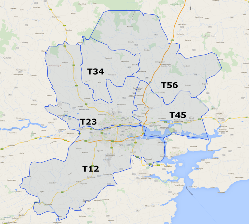
    Alias no.9's effort above inspired me to throw this together. Easy enough looking at the An Post delivery zones and checking the edges of them. The border between T34 and T56 took a while though as they're together on the delivery zones map. Feel free to flag mistakes.

    Map made up from:
    T12 seems to be seven delivery zones in the Cork City south area
    T23 looks like the 3 North Cork City delivery zones together with the Blarney area
    T56 is the Watergrasshill area
    T45 is Carrigtwohill, Glounthaune and Little Island
    T34 is together with T56 on the An Post delivery zones but I managed to make a rough approximation of the border between them by checking a bunch of spots on the maps and working out the delivery routes and what has to be the boundary between them.

    eircodesmap_1.png


  • Registered Users, Registered Users 2 Posts: 1,341 ✭✭✭SPDUB


    murphaph wrote: »
    Interesting. I suspected that post to these areas was being routed through these sorting offices, even though nobody in these areas has ever been told or asked to begin using these postal districts in their addresses.

    Who has the authority to create/amend postal districts I wonder? Do An Post have a legal right to just "annex" somewhere like Portmarnock into D13? Could An Post change the boundaries and make D6 bigger at the expense of D4, for example? I would imagine something like that would go down like a lead balloon among the affected property owners.

    Interesting about Lucan....so does mail being sent to Lucan go via the D22 sorting office like mail for Newcastle?

    As far as I know Lucan still has it's own labels for mail but just that when a driver collects mail from the Dublin Mail Centre it is now the D22 driver but when it reaches the delivery office building it is moved to it's own section of the building

    By running it as a co located office An Post has been able to reduce the number of vans and trucks and of course jobs needed then if they were in separate premises

    D10/D20 have been co located for a number of years with separate collection points for members of the public coming to pick up their post

    I presume Lucan has a separate collection point as well


  • Registered Users, Registered Users 2 Posts: 315 ✭✭moyners


    Cork 'T' eircodes from post above done on Google maps

    https://goo.gl/maps/zDCmY


  • Advertisement
  • Registered Users, Registered Users 2 Posts: 7,402 ✭✭✭plodder


    What would the population of those areas be? Close to 100,000 each probably. Compare with A41 in North County Dublin. Population is 400 households (probably less than 1,000 people). Extraordinary disparity.

    ballybog_zpsynplm3ym.png


  • Registered Users, Registered Users 2 Posts: 6,070 ✭✭✭OU812


    This thing is gonna be totally cracked inside three months.

    They really should have had more than 139 keys though. Something like this should be as granular as possible.


  • Registered Users, Registered Users 2 Posts: 184 ✭✭Aimead


    <removed>


  • Registered Users, Registered Users 2 Posts: 315 ✭✭moyners


    Aimead wrote: »
    I’m much more at home with chan sites and other places where, shall we say, moderation is done with a lighter hand. Boards.ie isn’t the typical place I’d post on, and I’ve been putting effort into holding back the sort of invective that I’d be free to post elsewhere.

    But, in this case, I’m going to make a bit of an exception and call you out for peddling a wilful and disingenuous strawman (not the first one either).

    Suppose someone gave you the following (making these up):
    T23 UUUU
    T23 VVVV
    T23 WWWW
    T23 XXXX
    T23 YYYY
    T23 ZZZZ

    You wouldn’t know where they where with reference to each. Now suppose someone had given me the following:
    BT56 UUU
    BT56 VVV
    BT56 WWW
    BT56 XXX
    BT56 YYY
    BT56 ZZZ

    I would now where they where with reference to each other. On visual inspection you can obtain useful information from the postcode that you do not obtain from Eircode. This point isn’t new and has been made multiple times in this thread. So why are you being deliberately disingenuous when the point being made is clear? You know that the routing boundaries are currently not known, and you know that it isn’t possible to tell where within a boundary a given Eircode is on visual inspection. To borrow your own phrase, isn’t a bit pathetic that an old code from the 60’s outperforms the supposedly modern Eircode in this scenario?

    To put it simply – if you really believe in the veracity of your defence of Eircode, then why do you continually play dumb as you have done so above?

    Think that reply was meant for the "National Postcodes to be introduced" thread?


  • Registered Users, Registered Users 2 Posts: 587 ✭✭✭L'Enfer du Nord


    xper wrote: »
    Since the postal areas were, surprise, surprise, entirely devised by and for the sole use of the forerunner of An Post, it should be no surprise that they exercise the right to enforce or amend them.
    Now, as we head into the world of demonopolised delivery services, it is appropriate that responsibility is shifted away from a single service provider and introducing Eircode is part of this shift. However, you mustn't break the system while changing the system, as the judge thankfully realised in the above care between Comreg and An Post.
    Apart from all that, it is ludicrously irrational to base the value of a residential property on the detail of how the state's incumbent postal service provider organises its deliveries. An Post or whoever ends up with the authority should have no regard for such nonsense.

    If you are not interested in the possible resale value the logical place to buy a property is in a less desirable post code on the border with a desirable one. My home is about 100 metres from a border. When I was bidding for the place I looked at similar properties nearby in order to set a limit, and since I had my heart set on the place I reasoned that if I didn't get it I'd try to get some where similar. All the similar places near by were asking at least 20% more, couldn't understand it until I realised they were in a different post code.

    Its nonsense on the one hand but on the other it really does effect the value of a property. You and I may feel we are above postcode snobbery but like it or not the market isn't.


  • Registered Users, Registered Users 2 Posts: 13,719 ✭✭✭✭Geuze


    Where is E42 routing key area?

    It is not on this list:

    https://en.wikipedia.org/wiki/List_of_Eircode_routing_areas_in_Ireland


  • Moderators, Science, Health & Environment Moderators Posts: 19,862 Mod ✭✭✭✭Sam Russell


    Mod: This is a very old thread, which should stay closed.


This discussion has been closed.
Advertisement