Advertisement
Help Keep Boards Alive. Support us by going ad free today. See here: https://subscriptions.boards.ie/.
https://www.boards.ie/group/1878-subscribers-forum

Private Group for paid up members of Boards.ie. Join the club.
Hi all, please see this major site announcement: https://www.boards.ie/discussion/2058427594/boards-ie-2026

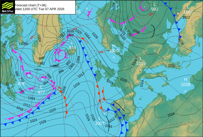
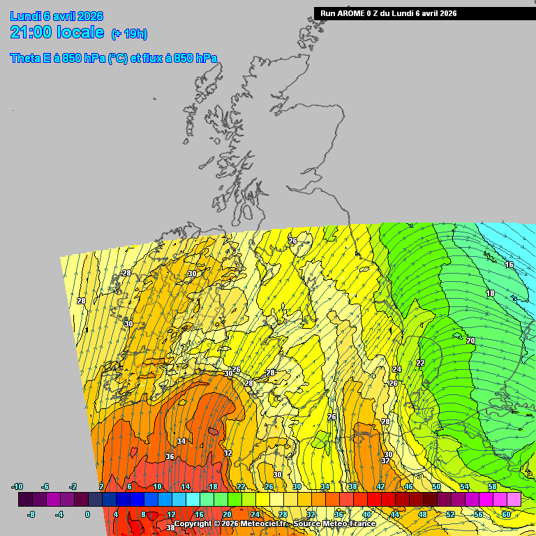
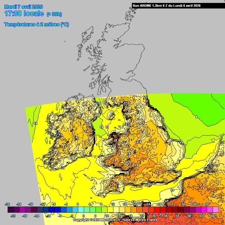
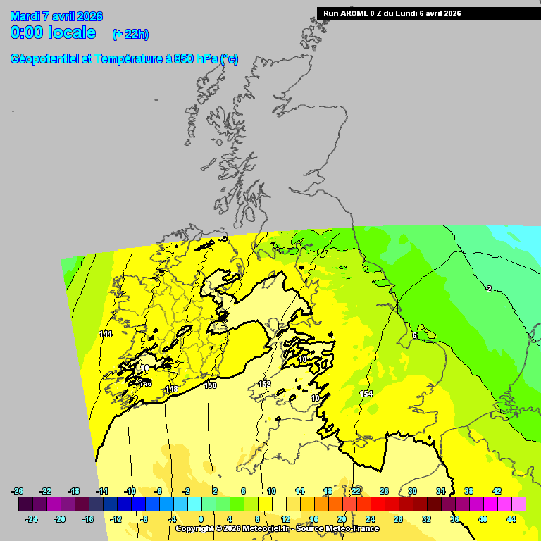
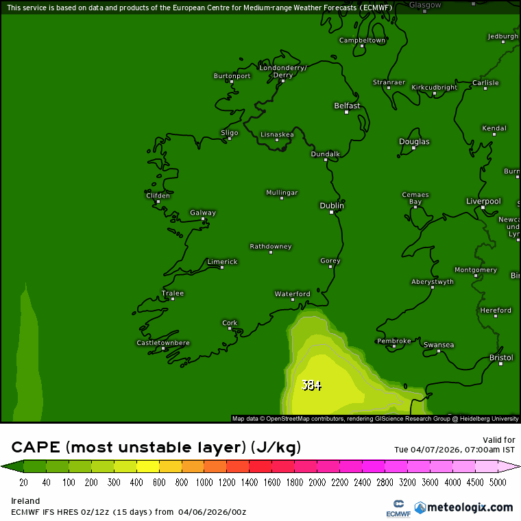
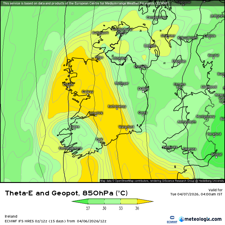
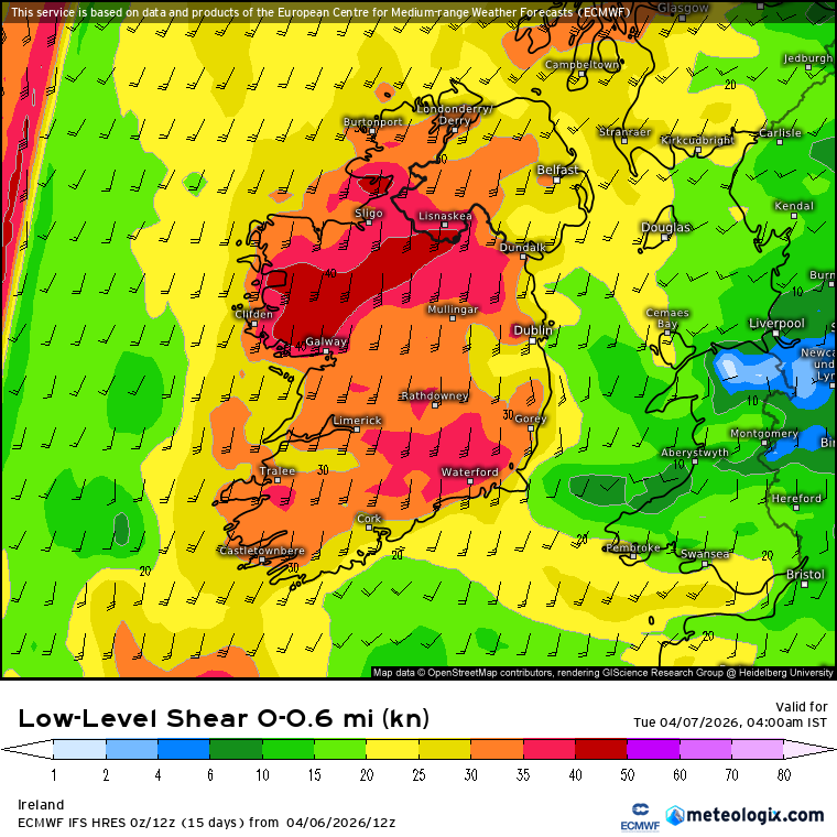
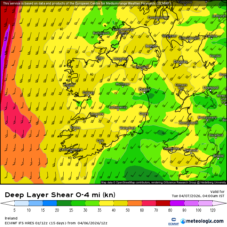
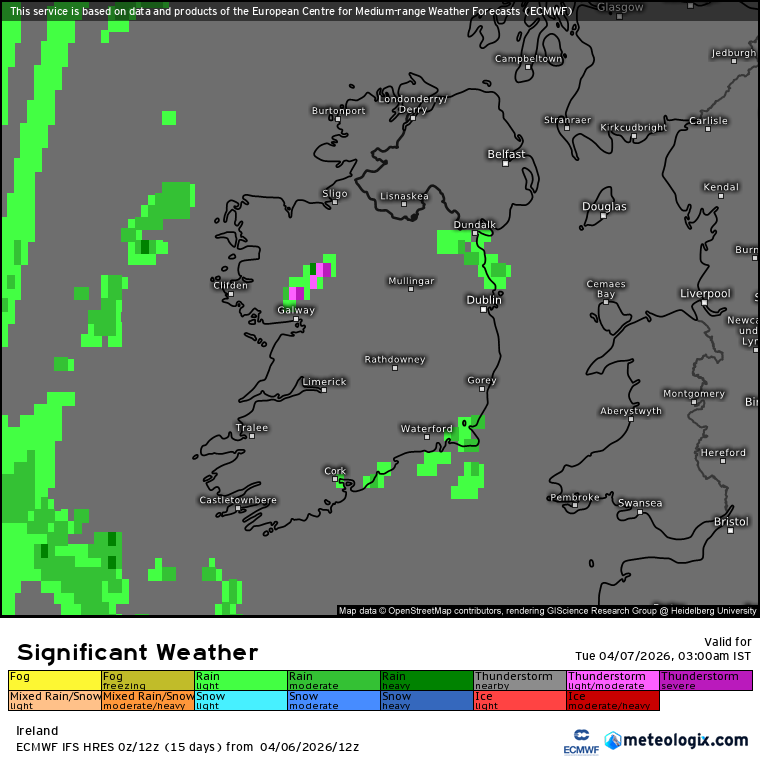
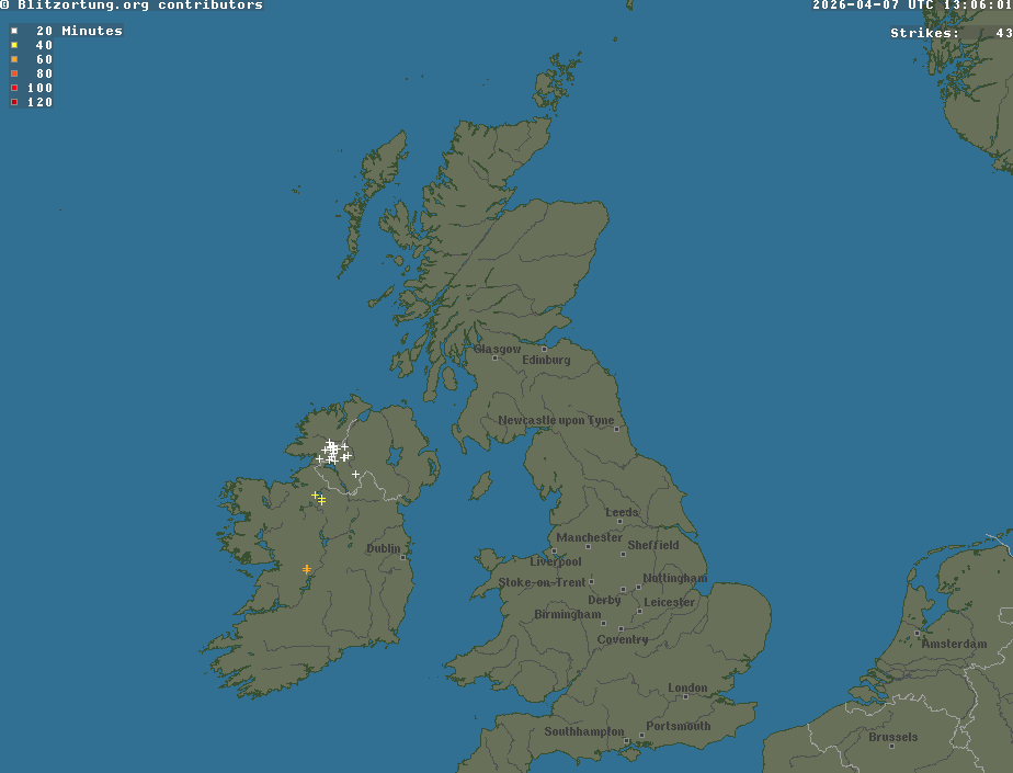
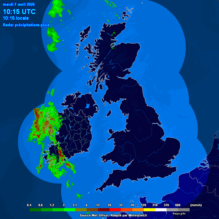
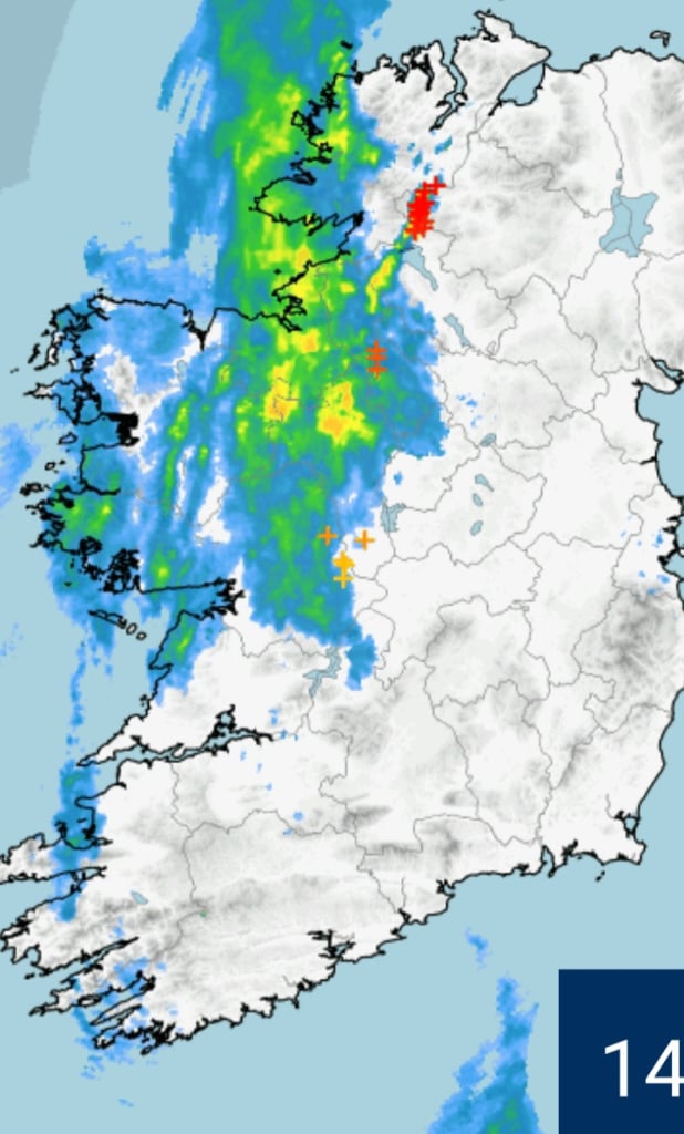
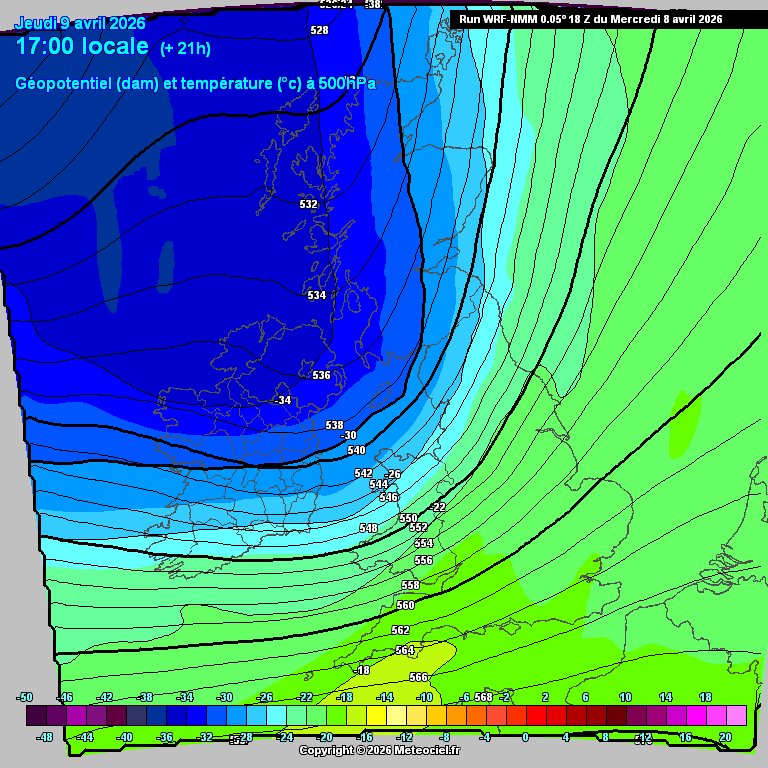
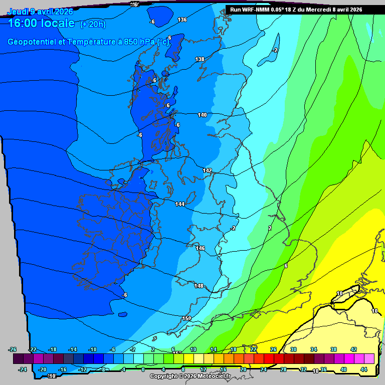
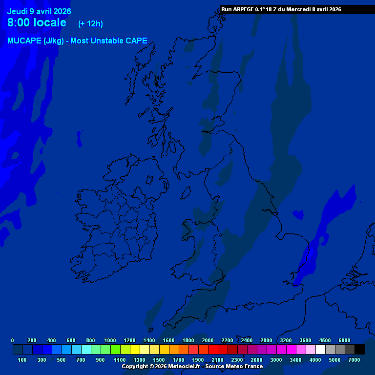
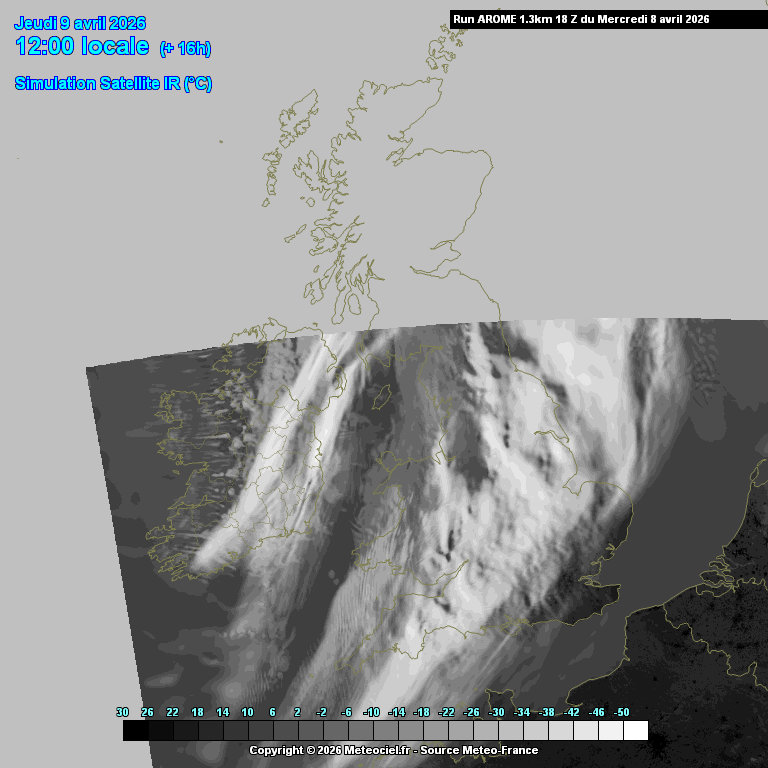
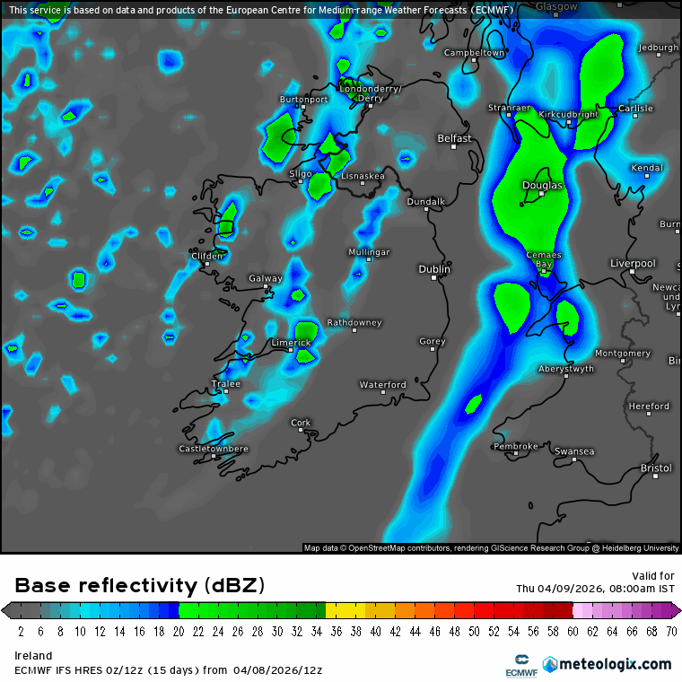
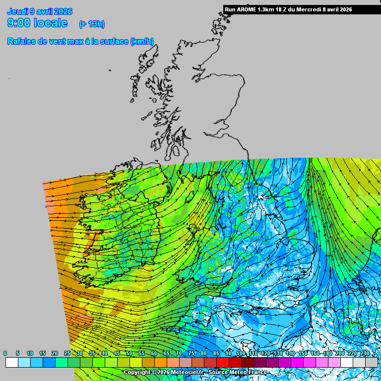
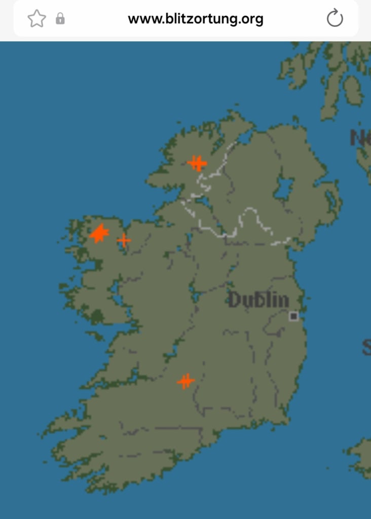
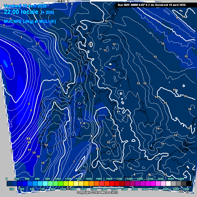
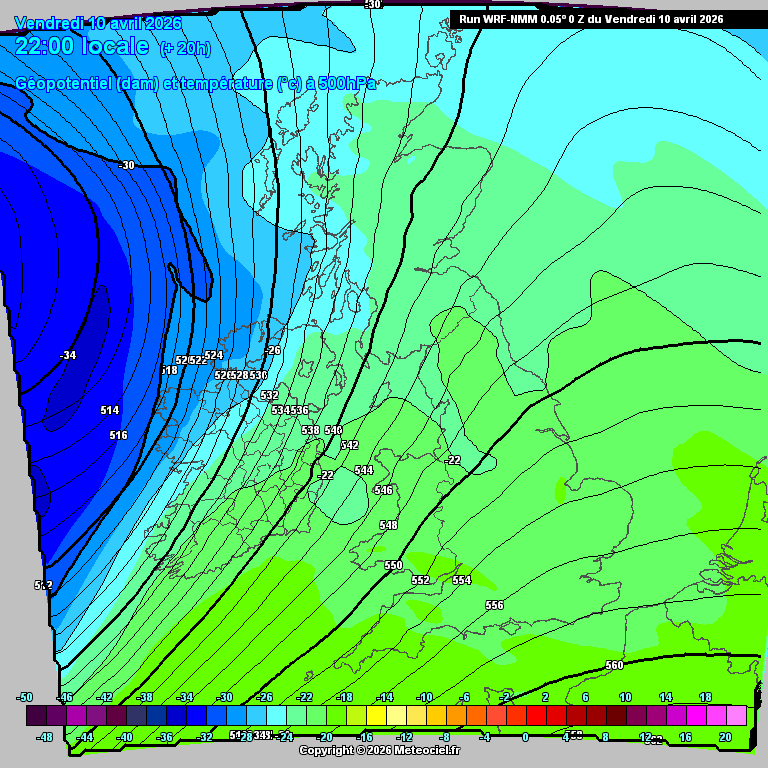
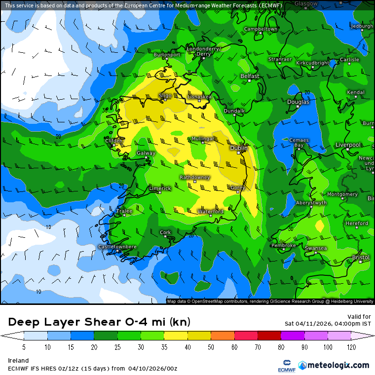
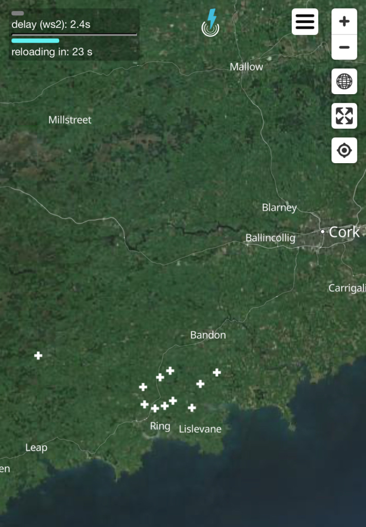
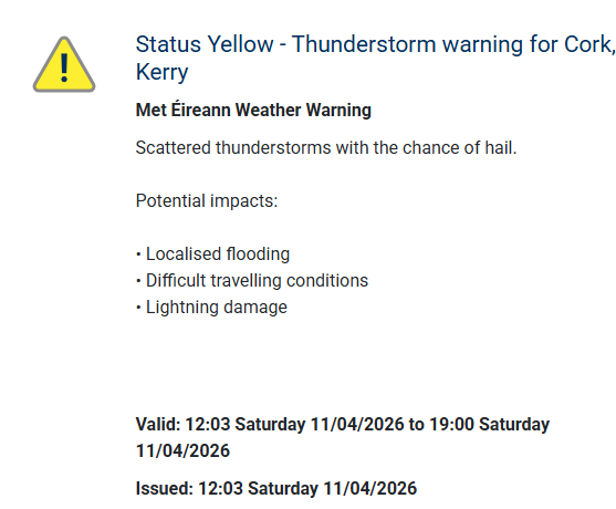
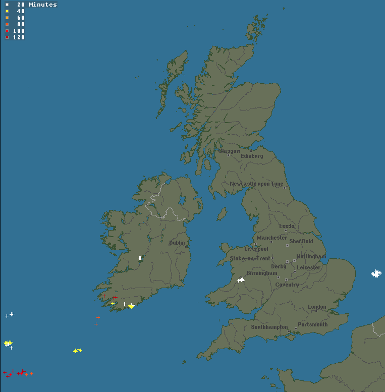
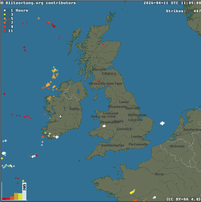
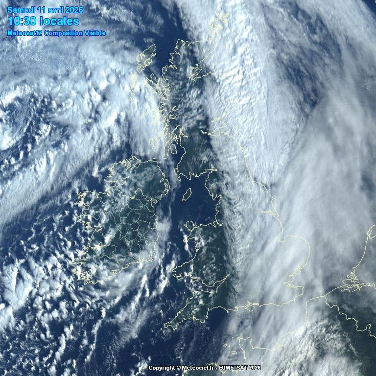
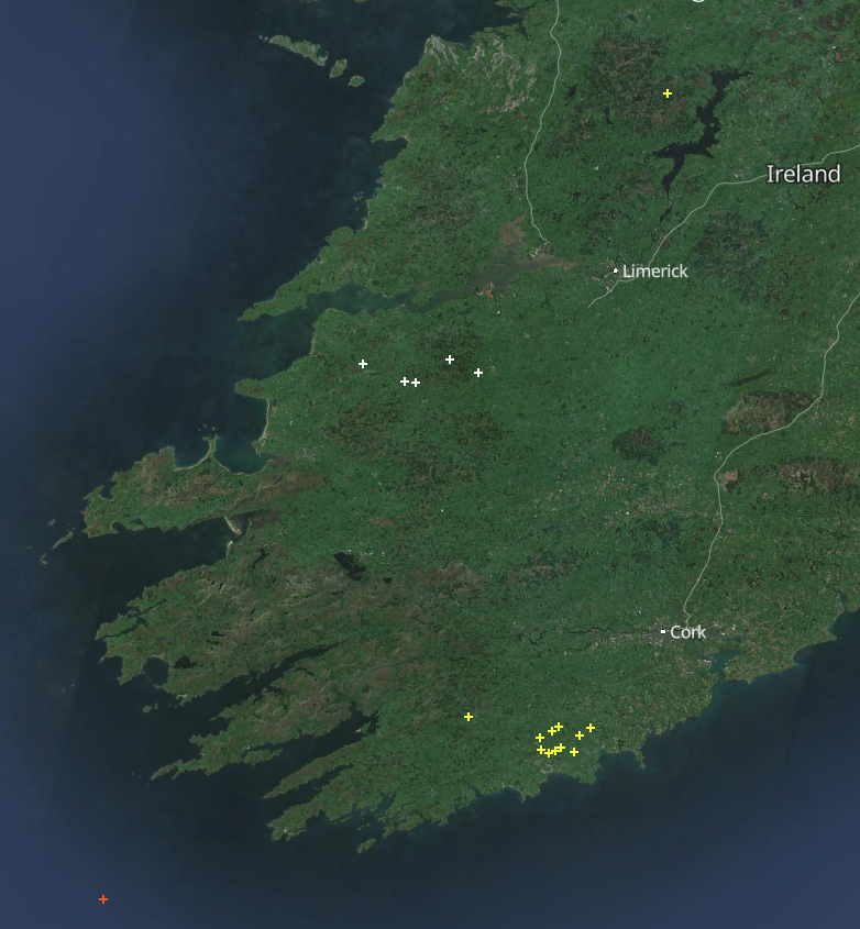
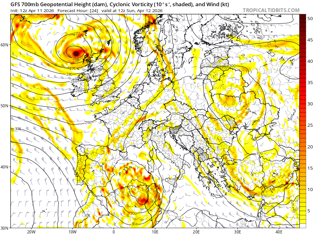
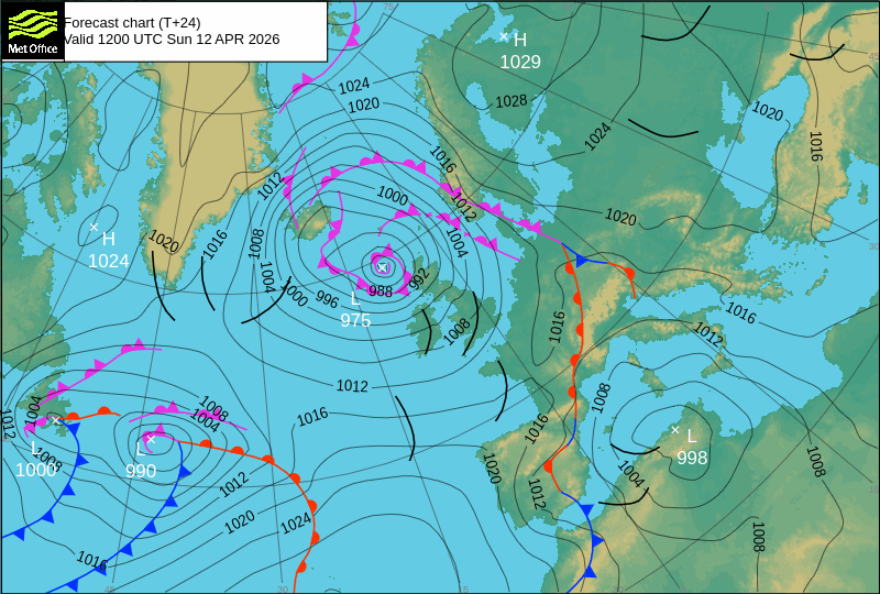
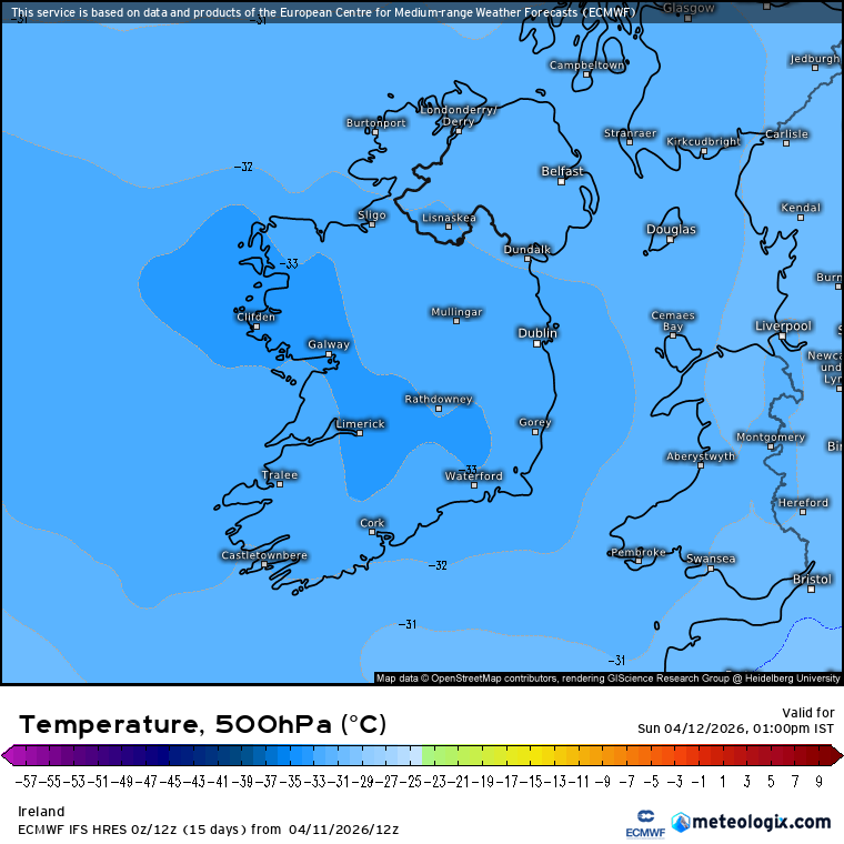
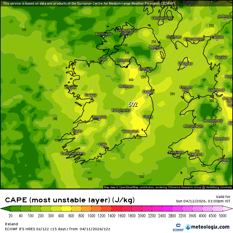
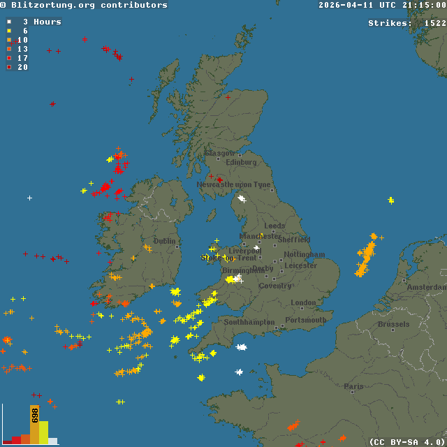
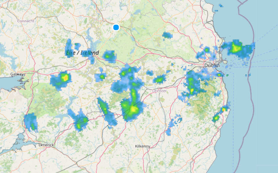
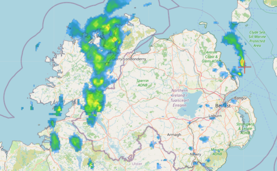
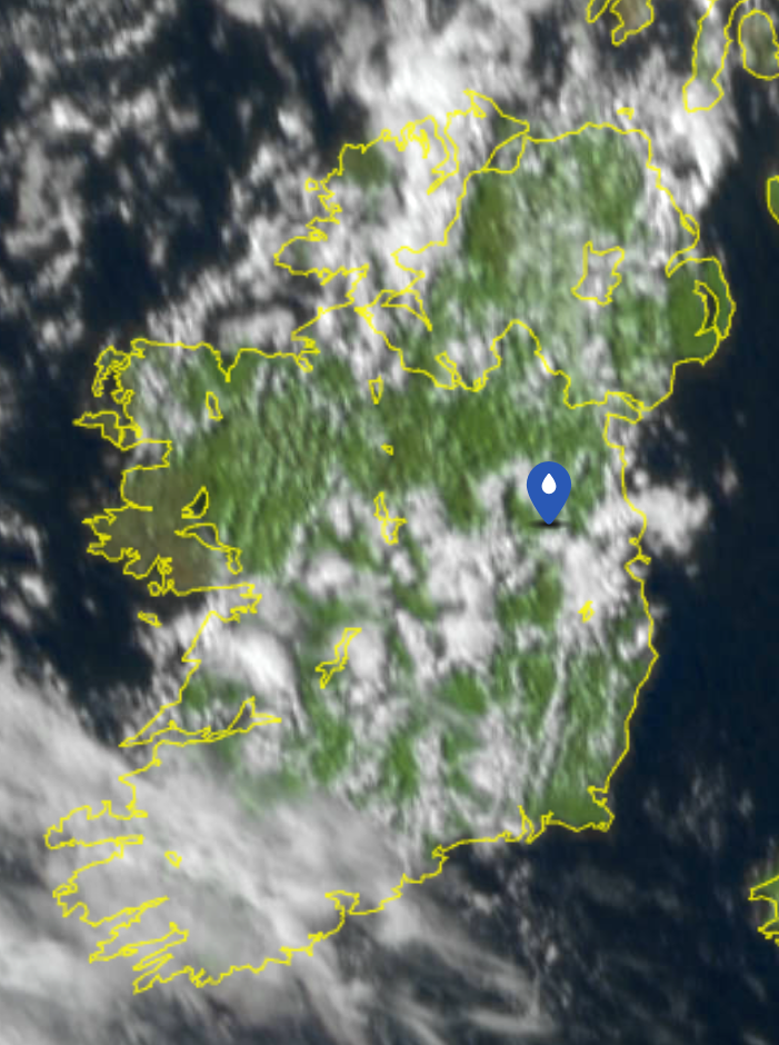
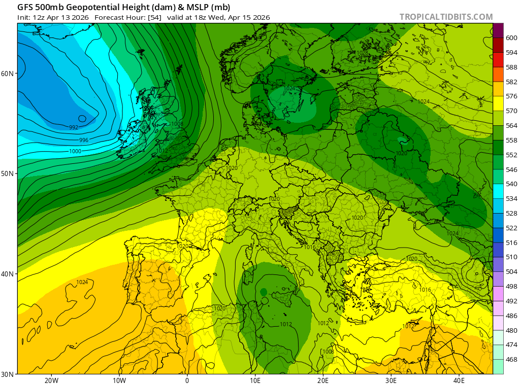
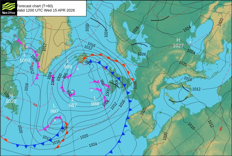
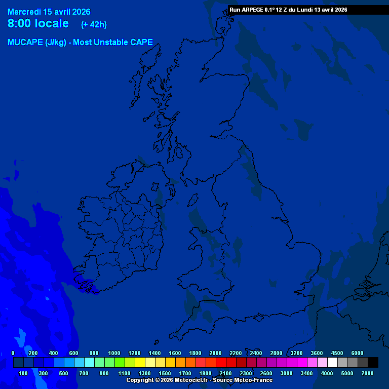
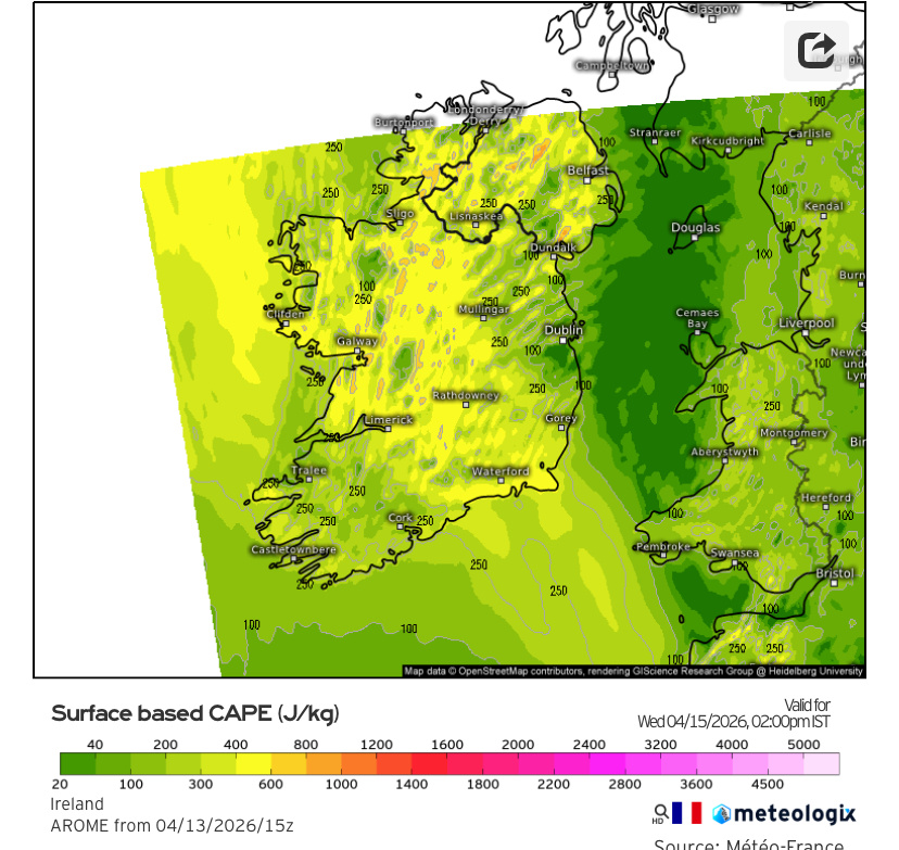
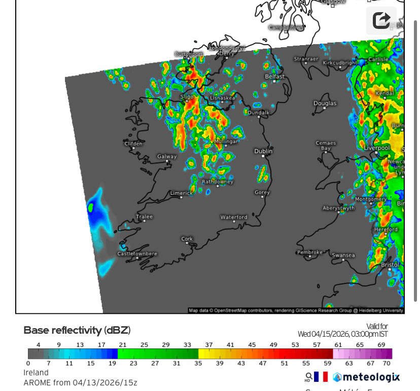
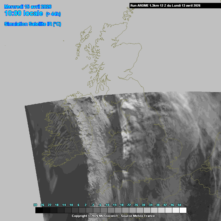
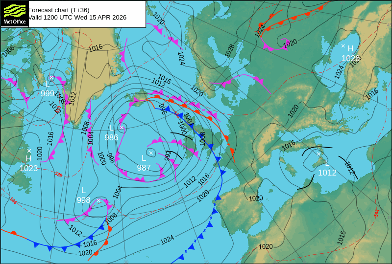
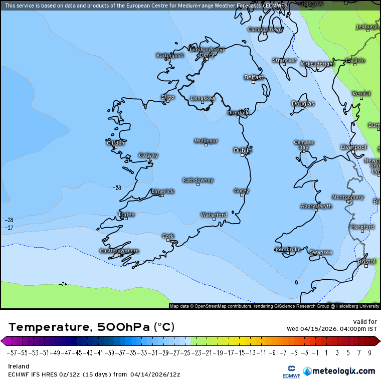
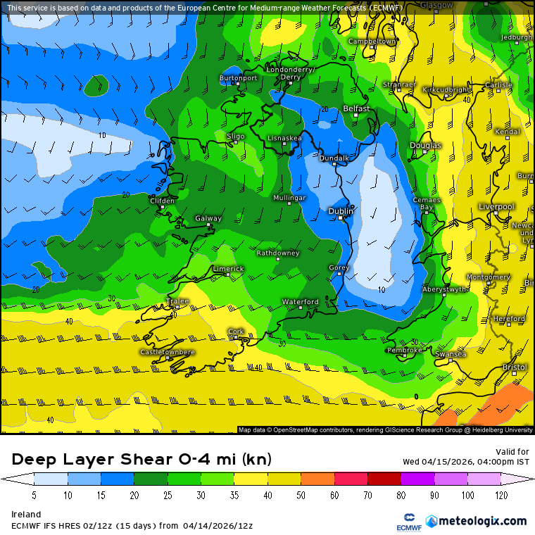
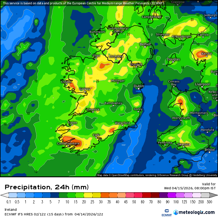
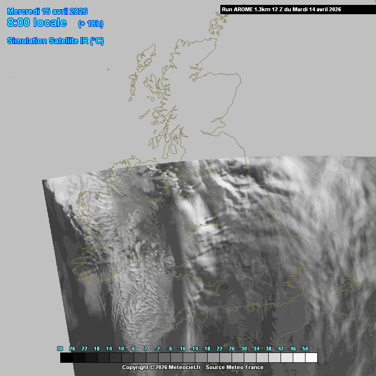
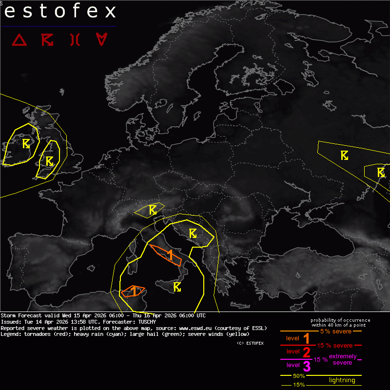
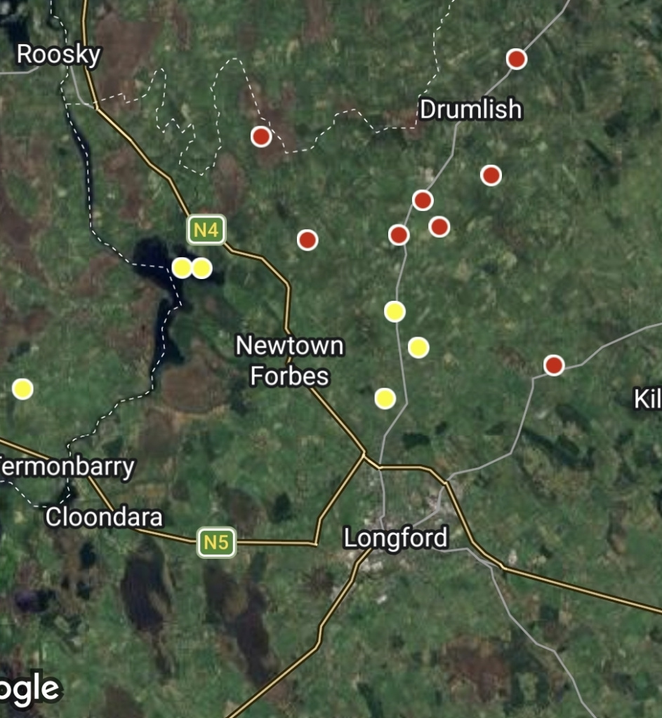
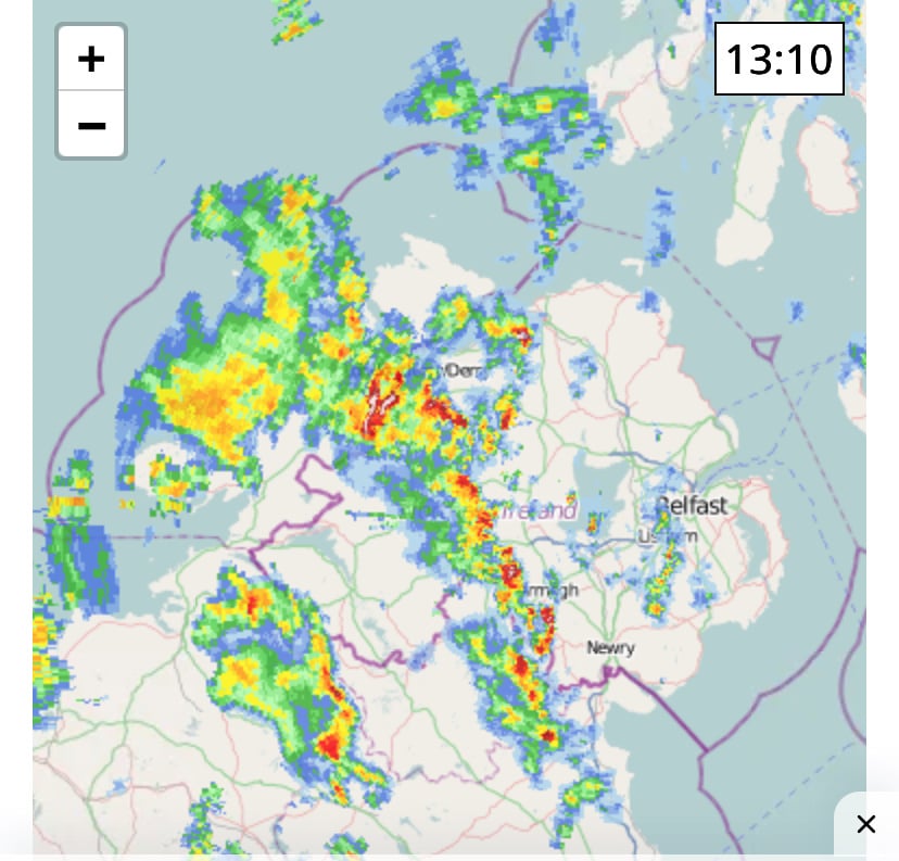
Convection /Thunderstorm discussion Spring /Summer 2026

  • 06-04-2026 11:35AM
    #1
    Moderators, Science, Health & Environment Moderators Posts: 13,545 Mod ✭✭✭✭


    From Met Eireann

    Tomorrow

    Tuesday will start off mostly dry with sunny spells in the east. It will be cloudier further west with showery rain in western coastal counties, heavy and possibly thundery at times. It will spread slowly eastwards through the late afternoon and evening, becoming lighter in the evening. Mild with highest temperatures of 13 to 17 degrees and moderate southeast winds, easing mostly light later.

    ………………………………………………………………………………………………..

    A change in the weather set up giving the more Spring / Summer type convection parameters, namely a warm plume of moisture rich airmass moving up from the South. Day time temperatures up to around 16 or 17C ( maybe 18C in the E ? ) with a high Dew point up around 12 or 13C. Have a weak cold front approaching from the W slowly making its way inland. Some LLS and DLS available, converging winds from the Cold Front might be a bit too late in the day but will see. Currently models showing potential of a few hundred J/kg . Maybe isolated in nature but sometimes these kind of storms can last a bit if they get fired up, parameters just more in the positive side of potential . Anyway a chance to get into the spring / summer type set ups and try and plot the course of the instability leading to convective rainfall and thunderstorm potential. Will see if any update on tonight's charts.

    FSXX00T_36 (6).gif

    Untitled Image

    Untitled Image

    Untitled Image

    modez_20260407_0600_animation.gif


«13456720

Comments

  • Moderators, Science, Health & Environment Moderators Posts: 13,545 Mod ✭✭✭✭Meteorite58


    ECM suggesting thunderstorms possible in the early hours coming up from the south, isolated in nature. showing an area in Connaught possible with strong low and deep layer shear,, tongue of high Theta E readings and good lapse rates. Will see if anything comes of it.

    xx_model-en-324-0_modez_2026040612_15_949_541.png

    xx_model-en-324-0_modez_2026040612_15_949_245.png xx_model-en-324-0_modez_2026040612_15_949_244.png

    xx_model-en-324-0_modez_2026040612_14_949_155 (1).png


  • Moderators, Science, Health & Environment Moderators Posts: 13,545 Mod ✭✭✭✭Meteorite58


    Missing the heavy rain here near Tralee. Some storms in the NW now and earlier in N Clare /S Galway.

    Nothing overland overnight apart from well out to sea off the NW.

    image.png

    lastradar_uk.gif


  • Registered Users, Registered Users 2 Posts: 10,841 ✭✭✭✭Oscar Bravo


    Few sparks around

    20260407_142100.jpg


  • Moderators, Science, Health & Environment Moderators Posts: 13,545 Mod ✭✭✭✭Meteorite58


    Best chance of isolated thunderstorms tomorrow would appear to be the top half of the country and probably better towards the top third where the best lapse rates are. Big convective showers tomorrow and blustery in those showers with hail very possible under those cold uppers. AROME showing well the possibility of blustery local conditions ahead or under some of those showers.

    Not a huge amount of CAPE but we will see if we get a scattering of thunderstorm's.

    Untitled Image

    Untitled Image

    Untitled Image

    Untitled Image

    modez_20260409_1700_animation.gif

    Untitled Image


  • Moderators, Science, Health & Environment Moderators Posts: 13,545 Mod ✭✭✭✭Meteorite58


    Not a lot of activity but some sferics recorded today.

    Screenshot_20260409_223619_Samsung Internet.jpg


  • Advertisement
  • Moderators, Science, Health & Environment Moderators Posts: 13,545 Mod ✭✭✭✭Meteorite58


    Instability increasing from the West after the frontal passages later on tonight, wintry showers along Atlantic coastal counties , some of hail and risk of thunderstorm's, possibly mostly over the sea but a chance of some straying onshore. Tomorrow enough CAPE and upper instability from deep layer shear and cold pool aloft as occluded fronts/ troughs cross the country producing big convective showers, hail possible and isolated thunderstorms just about anywhere I would think.

    Untitled Image

    Untitled Image

    xx_model-en-324-0_modez_2026041000_39_949_244.png


  • Registered Users, Registered Users 2 Posts: 48 leprechauntimmer123


    Yeah, could definitely see a threat for any mature shower/thunderstorms that get going to produce locally damaging winds and small hail/sleet. Over in Dublin, the usual typical that we'll probably miss out on anythingtthat gets going tomorrow. Slightly warmer temperatures aloft might do it in for us combined that we don't have the greatest instability. I'll remain hopeful but don't see much for my area tmrw. Could be a interesting day Central portion of the country though


  • Registered Users, Registered Users 2 Posts: 661 ✭✭✭Ros4Sam24


    Thunderstorm near the south coast in Cork

    IMG_1506.jpeg

    I think there could be a few around today, mainly in the south


  • Registered Users, Registered Users 2, Paid Member Posts: 273 ✭✭tromtipp


    rumbly rumble west of Nenagh just now.


  • Moderators, Science, Health & Environment Moderators Posts: 13,545 Mod ✭✭✭✭Meteorite58


    They could be extending the warnings to more counties yet.

    image.png

    Current

    image.png

    Since midnight

    image.png


  • Advertisement
  • Registered Users, Registered Users 2 Posts: 710 ✭✭✭Tazio


    Very heavy hail stones outside riverstick.. very dark clouds to the west.


  • Registered Users, Registered Users 2 Posts: 10,841 ✭✭✭✭Oscar Bravo


    ⚠️Thunderstorm Yellow Warning⚠️for Kerry, Cork, Waterford

    ⏲️12:00 to 19:00 Today, Sat 11/04/2026

    ❗️Be aware of the isolated thunderstorms with a chance of hail⛈️


  • Moderators, Science, Health & Environment Moderators Posts: 13,545 Mod ✭✭✭✭Meteorite58


    Sferics up around Listowel to Newcastle West now. Big blustery convection out there this morning.

    animsatviscolmtguk (1).gif

    image.png


  • Registered Users, Registered Users 2, Paid Member Posts: 273 ✭✭tromtipp


    Long thundery rumble away over Slieve Bernagh. Heavy hail.


  • Registered Users, Registered Users 2 Posts: 14,585 ✭✭✭✭leahyl


    extremely dark sky on north side of cork city now, something’s brewing…


  • Registered Users, Registered Users 2 Posts: 6,291 ✭✭✭Storm 10


    Lots of lightning well South of Cork looks to be missing the South Coast, lots of heavy showers moving in from the West hopefully we get something


  • Registered Users, Registered Users 2 Posts: 3 FrighteningLightning95


    So far just a bit of hail and rain in Mallow in the morning, hopefully we will get something soon 🤞


  • Moderators, Science, Health & Environment Moderators Posts: 13,545 Mod ✭✭✭✭Meteorite58


    Tomorrow under a negatively tilted longwave trough and very cold upper air aloft with the passage of a shortwave trough which could produce thunderstorms more overland during tomorrow afternoon during peak diurnal heating . Again could happen about anywhere. Possibly more activity than today. Less in the way of surface wind tomorrow , has an amount of LLS and DLS with decent lapse rates which could aid the development of a few more hefty longer lived storms perhaps. ECM showing CAPE up around 500 J/kg so decent enough.

    gfs_z700_vort_eu_5.png FSXX12T_24.gif

    xx_model-en-324-0_modez_2026041112_24_949_447.png xx_model-en-324-0_modez_2026041112_24_949_654.png

    Sferics which got detected since midnight.

    archive_3_image.png


  • Registered Users, Registered Users 2 Posts: 48 leprechauntimmer123


    Small hail shower just came thru North Dublin. Lots of it too came down but already melted. That was a nice surprise


  • Registered Users, Registered Users 2, Paid Member Posts: 506 ✭✭✭The Macho Man


    Forecast yesterday evening from Met Eireann was slow moving heavy possibly thundery showers across the country. Has barely been a drop of rain all day, another great call 🤨


  • Advertisement
  • Registered Users, Registered Users 2 Posts: 6,750 ✭✭✭highdef


    That's exactly what is happening at the moment though. There's a band/area of showers moving from south to north at the moment, as can be seen below.

    image.png

    There are also heavy showers/areas of rain in Ulster

    image.png

    Note that Shannon radar is down so the showers in the midlands and towards the west may be more numerous and heavier than the radar might suggest. The most recent visible satellite imagery suggests that the light enough shower showing up on radar to the north east of Ennis may be heavier and larger than the radar suggests.

    image.png


  • Moderators, Science, Health & Environment Moderators Posts: 13,545 Mod ✭✭✭✭Meteorite58


    Apart from all the big showers and hail on Tuesday only a few sferics showed up in Cork, today I don't think any recorded.

    The next decent chance of thunderstorms and possibly widespread at that if they get fired up is on Weds post frontal airmass as the upper trough goes through its negative phase and the passage of lower shortwave troughs and occluded fronts. Again a large upper pool of cold air aloft and decent amounts of LLS and some DLS set to give decent instability/ Lapse Rates. current indications are for CAPE getting up from 500 to 700 J/Kg in places , the highest reading I have seen since some of the big storms last summer perhaps . Has the look of being active. Will see how the charts pan out tomorrow.

    gfs_z500_mslp_eu_10.png FSXX00T_60 (2).gif

    Untitled Image


  • Registered Users, Registered Users 2 Posts: 661 ✭✭✭Ros4Sam24


    Some thunderstorms possible Wendsday afternoon? @Meteorite58

    IMG_1508.jpeg IMG_1509.jpeg

    Some decent Cape values especially for the time of year.


  • Moderators, Science, Health & Environment Moderators Posts: 13,545 Mod ✭✭✭✭Meteorite58


    Yeah looks like a decent chance all right Ros4Sam24, highest CAPE readings in some time, widespread at that and possibly strongest in the Northern half of the country like the AROME charts show above.

    Nice looking cloud formation simulation, would be some showers from that and hail too. One to watch.

    Untitled Image


  • Moderators, Science, Health & Environment Moderators Posts: 13,545 Mod ✭✭✭✭Meteorite58


    Parameters strong for widespread heavy convective rainfall with hail and thunderstorms looking likely tomorrow from mid to late morning through the afternoon and possibly into late afternoon early evening in Northern counties.

    Local flooding or spot flooding possible especially if under a some of those very heavy showers forecast for tomorrow after the front passes through which in itself should drop a fair bit of water.

    Shear available lower down and in the upper levels under the cold pool aloft. Passage of troughs and occluded front under the upper negative tilted trough all aiding instability, models in fair agreement of CAPE between 600 -700 J/kg available in places.

    Windy too and blustery in some of those big convective showers.

    Think could get thunderstorms about anywhere but probably the most active from a line say from Limerick up heading towards Northern counties. Can see warnings for rainfall accumulations /thunderstorms coming into effect.

    FSXX00T_36 (6).gif

    xx_model-en-324-0_modez_2026041412_27_949_447.png

    xx_model-en-324-0_modez_2026041412_27_949_244.png

    xx_model-en-324-0_modez_2026041412_31_949_63.png

    Untitled Image


  • Registered Users, Registered Users 2 Posts: 6,036 ✭✭✭Comhrá


    "Think could get thunderstorms about anywhere but probably the most active from a line say from Limerick up heading towards Northern counties. Can see warnings for rainfall accumulations /thunderstorms coming into effect."

    Bring them on!


  • Moderators, Science, Health & Environment Moderators Posts: 13,545 Mod ✭✭✭✭Meteorite58


    2026041606_202604141358_1_stormforecast.xml.png

    https://www.estofex.org/

    SYNOPSIS and DISCUSSION

    Ridging and extensive anticyclones dominate the weather over most of Europe. One exception is the quasi-stationary cut-off over/just W of Sicily and a progressive upper trough over NW Europe, which swings from Ireland N towards Scotland.

    Over NW Europe, a moist postfrontal airmass offers up to 500 J/kg MUCAPE as temporal diabatic heating kicks in from the SW. Strongest storms may pose some graupel and gust risk, although the combination of a moist airmass with low LCLs and improving 3CAPE could also support a funnel/short-lived tornado event mainly over E/N Ireland and W/SE UK. The risk abates after sunset and the magnitude of the severe risk does not justify a level issuance.


  • Registered Users, Registered Users 2 Posts: 548 ✭✭✭Donegal Ken


    Leitrim, Sligo, Fermanagh, Cavan, Monaghan, Donegal, Longford, Roscommon and Tyrone look like the Hotspots early and then over the later afternoon and evening Mid/East Ulster and north Leinster.

    I am actually surprised the UKMO has no warnings out but would expect one this morning at some stage for Northern Ireland. Met Eireann will be the normal as the cells develop.


  • Registered Users, Registered Users 2 Posts: 6,750 ✭✭✭highdef


    Over a dozen recent strikes just north of Longford town.

    1000085495.jpg


  • Advertisement
  • Registered Users, Registered Users 2 Posts: 661 ✭✭✭Ros4Sam24


    Looks like cells are beginning to fire. Looks like Derry city is about to get hammered very soon

    IMG_1516.jpeg


Advertisement
Advertisement