Advertisement
Help Keep Boards Alive. Support us by going ad free today. See here: https://subscriptions.boards.ie/.
https://www.boards.ie/group/1878-subscribers-forum

Private Group for paid up members of Boards.ie. Join the club.
Hi all, please see this major site announcement: https://www.boards.ie/discussion/2058427594/boards-ie-2026

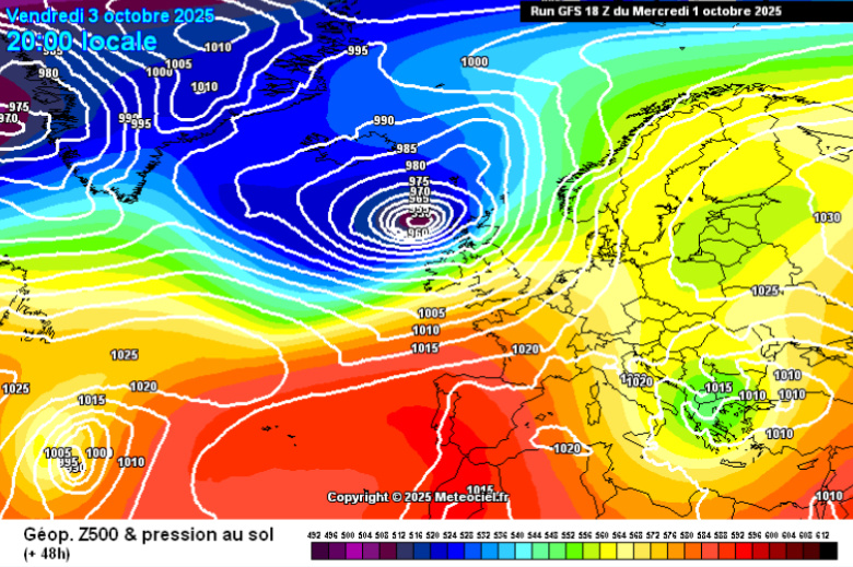
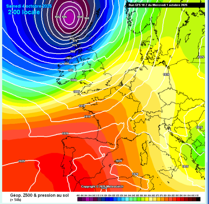
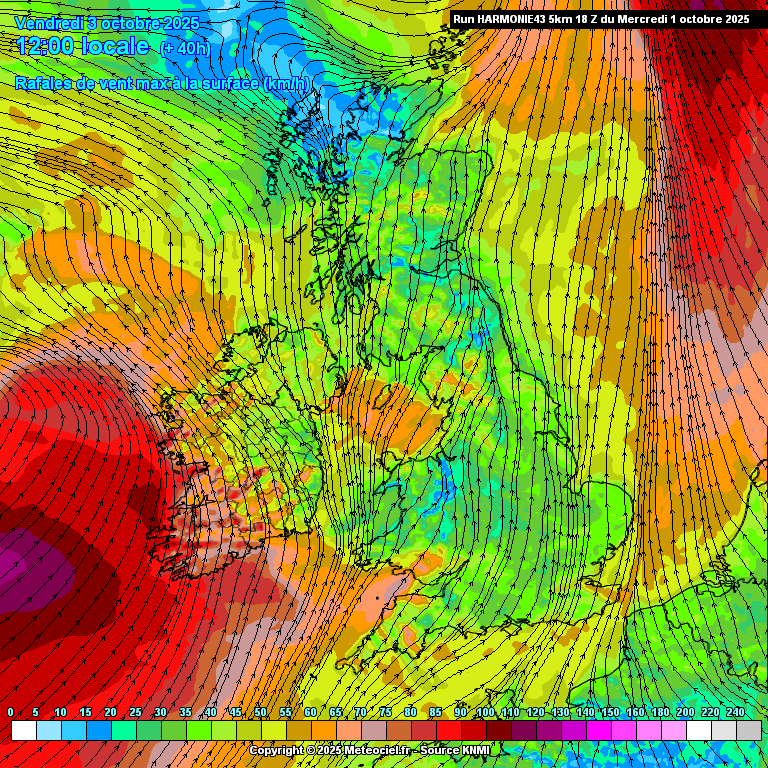
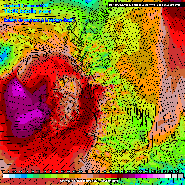
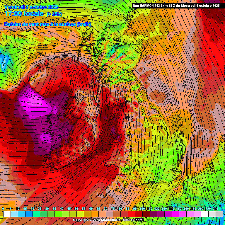
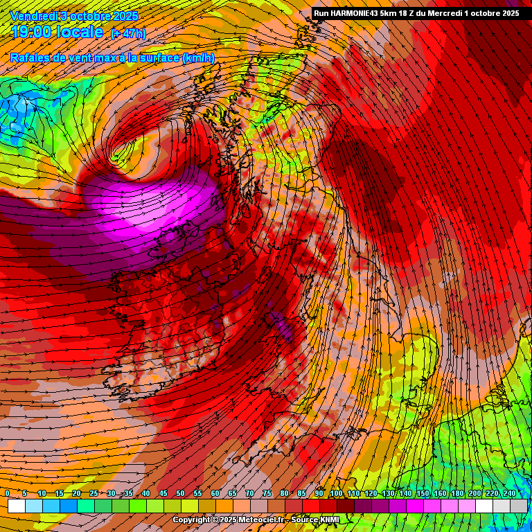
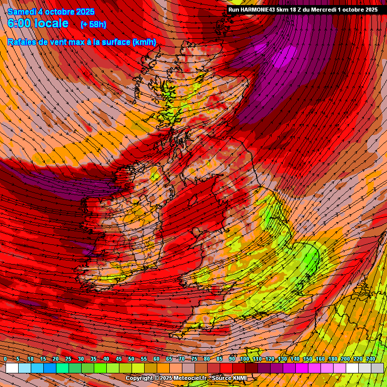
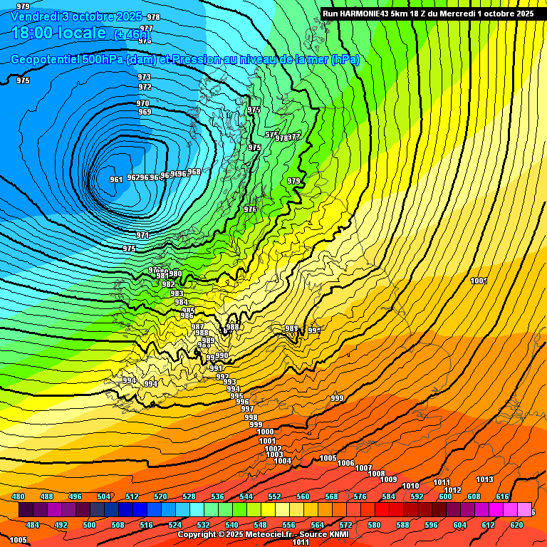
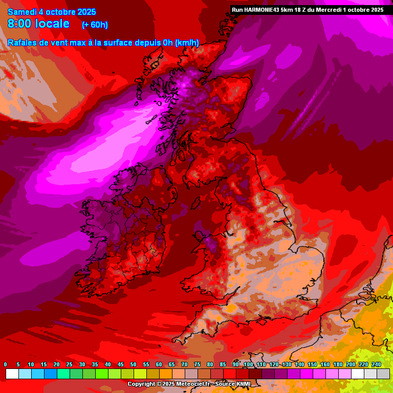
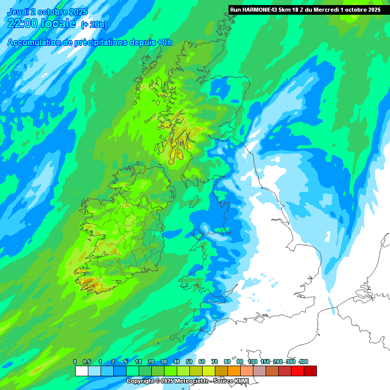
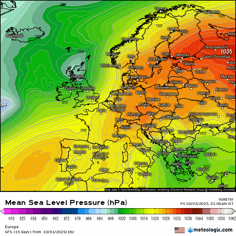
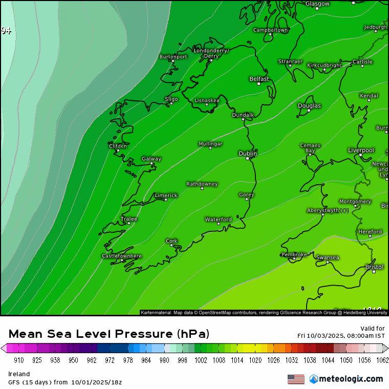
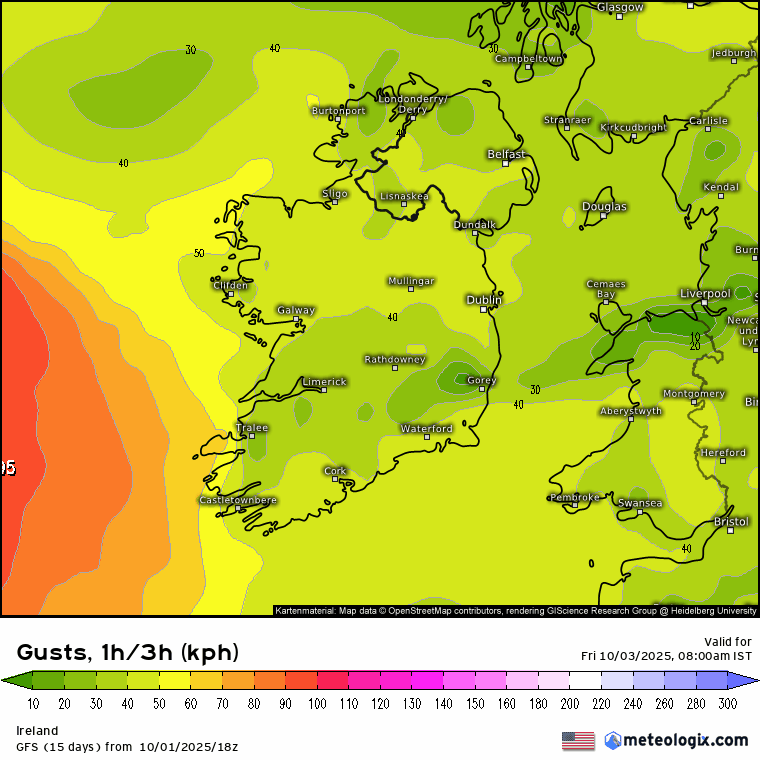
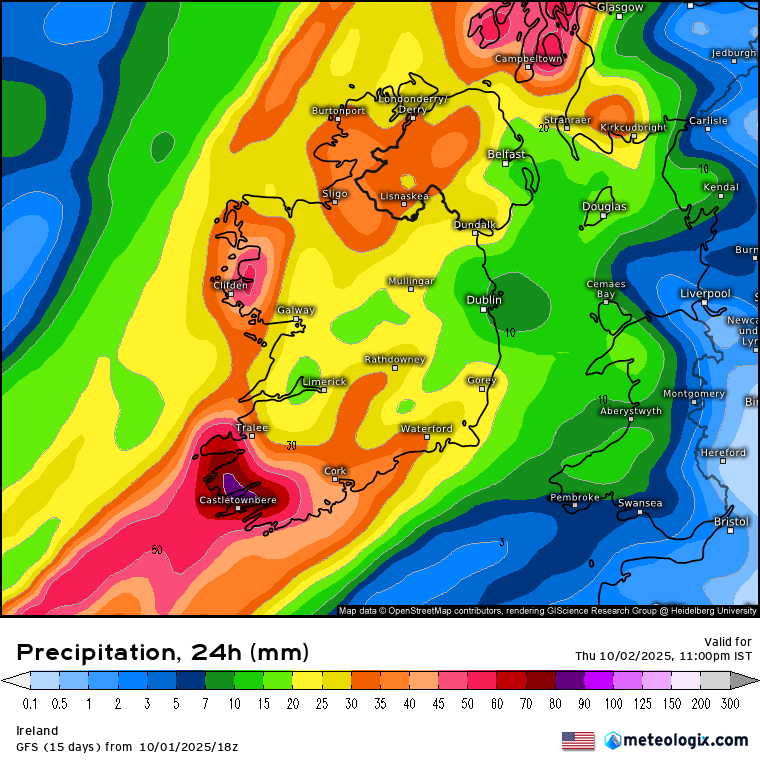
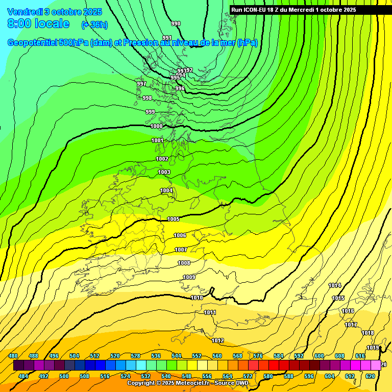
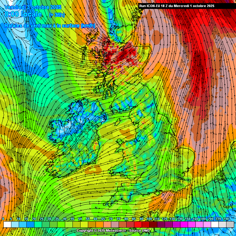
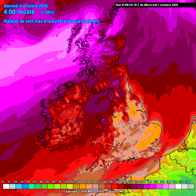
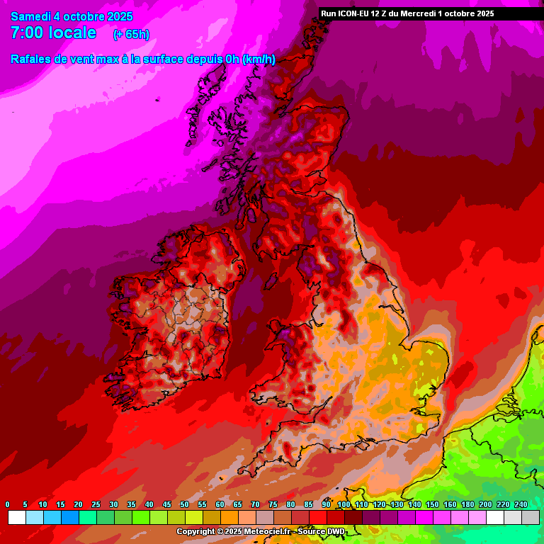
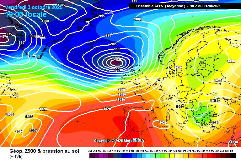
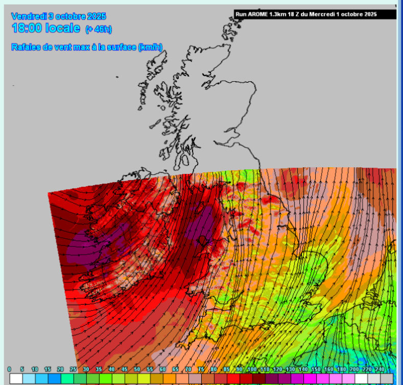
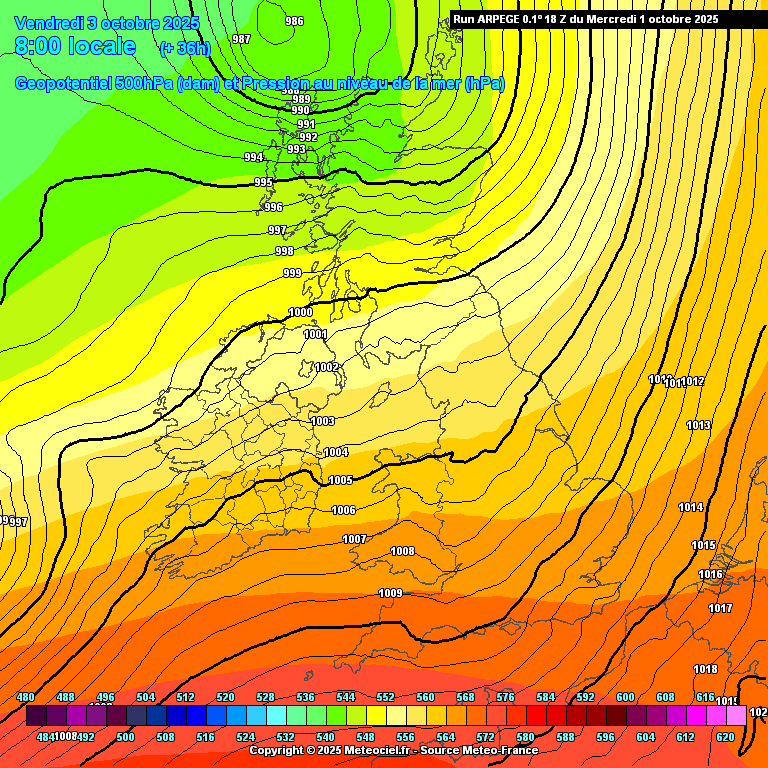
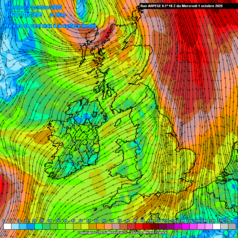
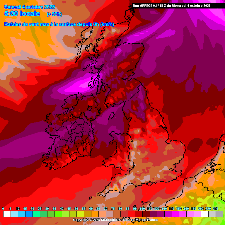
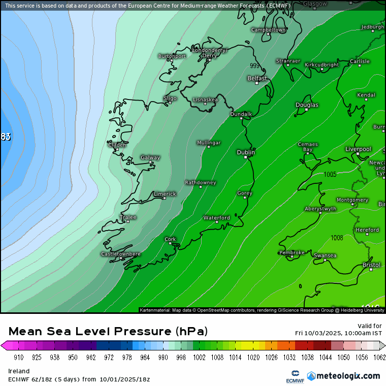
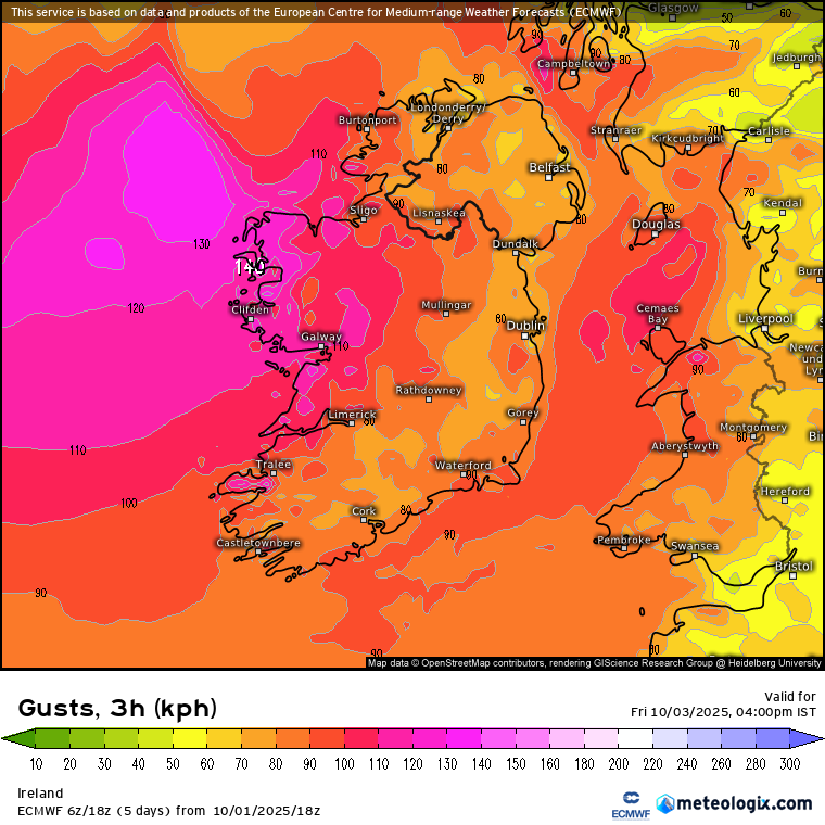
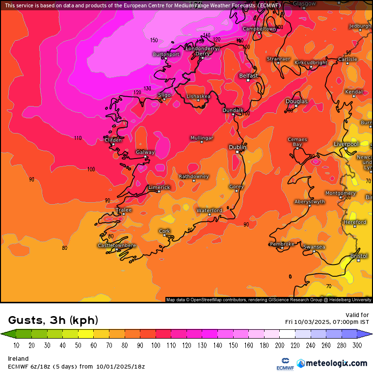
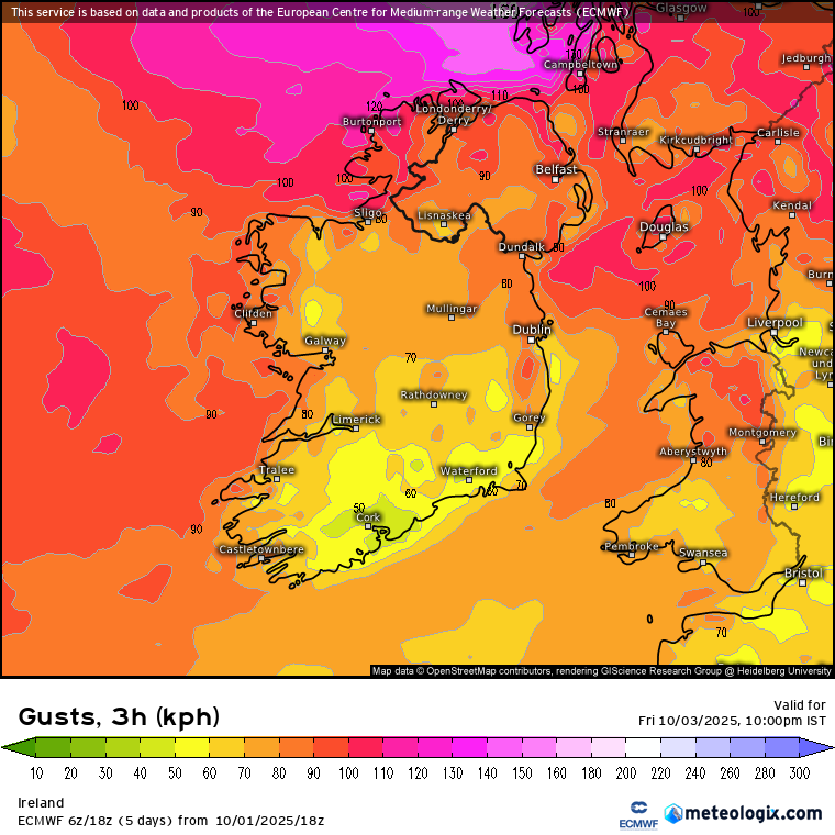
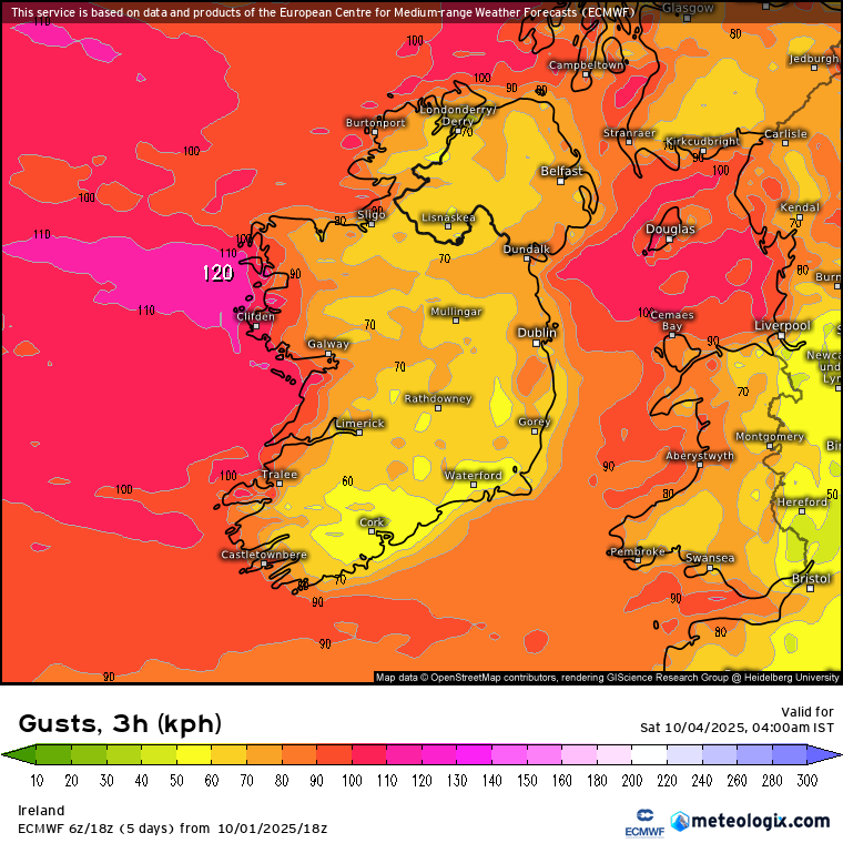
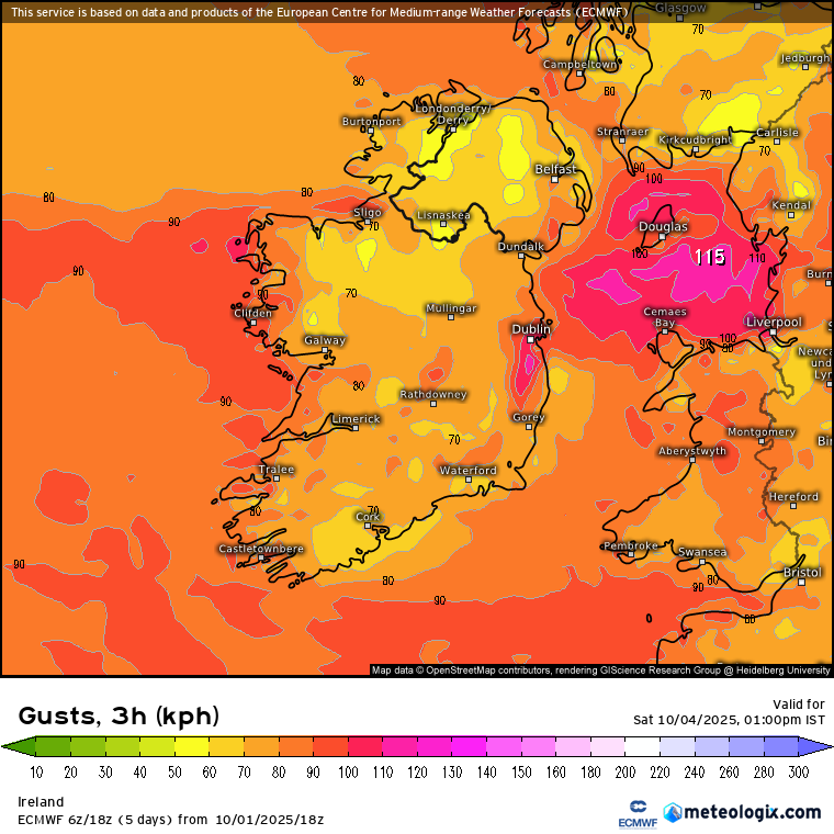
Heavy Rainfall Thurs 2nd & Storm Amy Watch Fri 3rd -Sat 4th Oct 2025

1235725

Comments

  • Registered Users, Registered Users 2 Posts: 937 ✭✭✭Robwindstorm


    GFS Drumroll ddddddddd-tishhhh


  • Registered Users, Registered Users 2 Posts: 3,569 ✭✭✭JanuarySnowstor


    The gfs nudges closer on 18z. Interesting

    On a separate note Cork should be added to Orange rainfall for tomorrow's ppn event


  • Registered Users, Registered Users 2 Posts: 473 ✭✭Ros4Sam24


    Gfs following others going South!

    Not a total jump ship but a trend south continues from the models

    IMG_0954.jpeg IMG_0955.jpeg


  • Moderators, Science, Health & Environment Moderators Posts: 13,132 Mod ✭✭✭✭Meteorite58


    Considerable upgrade now from HARMONIE bringing most probably Orange warning levels up along the W and NW and maybe counties in from the coast too if this keeps moving closer to Ireland as it is showing. Would imagine the ECM will be that bit closer again on the 18Z, will see.

    It is also showing some high rainfall totals in Clare, maybe a bit more than Yellow warning level. Will compare with other output later.

    Untitled Image

    Untitled Image

    Untitled Image

    Untitled Image

    Untitled Image

    Untitled Image

    Untitled Image

    Untitled Image


  • Moderators, Science, Health & Environment Moderators Posts: 13,132 Mod ✭✭✭✭Meteorite58


    GFS that bit stronger again bringing the higher winds some bit further inland . Not as windy as other models the following day as it clears the system off to the North.

    Deepening rapidly passing Ireland and showing to get down eventually to 942mb, slightly lower than the ECM at 945mb. ECM shows a very wide wind field to stay over us longer on Saturday.

    GFS showing some amount of rainfall in 24hrs in the SW in fact it is showing most of the rain to be cleared from the SW by about 18.00- 19.00.

    modusa_20251004_1200_animation (2).gif

    modusa_20251004_1200_animation (1).gif

    modusa_20251004_1200_animation.gif

    xx_model-en-324-0_modusa_2025100118_28_949_63.png


  • Advertisement
  • Moderators, Science, Health & Environment Moderators Posts: 13,132 Mod ✭✭✭✭Meteorite58


    ICON yes that bit stronger again slowly nudging the system closer but always better to see a model make small changes rather then big ones for consistency and more reliability. Can compare the max gust charts below to see the difference from the 12Z to the 18Z

    Untitled Image

    Untitled Image

    Untitled Image

    Untitled Image


  • Moderators, Science, Health & Environment Moderators Posts: 1,684 Mod ✭✭✭✭WolfeEire
    Clare (430ft asl)


    The GEFS mean shows little if any change from earlier runs today. Status Orange Alerts likely for Donegal, Derry, Antrim and parts of Connacht (and maybe Clare because of stronger winds edging into the west of the county for an hour or two). A slight shift south could see Donegal edge into low red territory.

    gens-31-1-48.png

    www.weatheire.com


  • Registered Users, Registered Users 2 Posts: 473 ✭✭Ros4Sam24


    Wow Arome is really south 110kph gusts in the Midlands and Midwest

    IMG_0956.jpeg


  • Moderators, Science, Health & Environment Moderators Posts: 13,132 Mod ✭✭✭✭Meteorite58


    It's amazing how little the French models have deviated from the general track over the last number of runs.

    Untitled Image

    Untitled Image

    Untitled Image


  • Moderators, Science, Health & Environment Moderators Posts: 13,132 Mod ✭✭✭✭Meteorite58


    EECM 18Z stronger again over a wider area but probably going through a bit quicker, some strong overnight winds in the W also, more like HARMONIE and ARPEGE now.

    modezrpd_20251003_0900_animation.gif xx_model-en-324-0_modezrpd_2025100118_45_949_93.png xx_model-en-324-0_modezrpd_2025100118_48_949_93.png xx_model-en-324-0_modezrpd_2025100118_51_949_93.png xx_model-en-324-0_modezrpd_2025100118_57_949_93.png

    xx_model-en-324-0_modezrpd_2025100118_66_949_93.png


  • Advertisement
  • Registered Users, Registered Users 2, Paid Member Posts: 595 ✭✭✭coillsaille


    Impressive lightning and thunder over Galway Bay right now.


  • Registered Users, Registered Users 2 Posts: 6,189 ✭✭✭Storm 10


    Some big flashes ok


  • Registered Users, Registered Users 2 Posts: 6,189 ✭✭✭Storm 10


    LLoud Thunder now and plenty of flashes in Galway torrential rain


  • Registered Users, Registered Users 2 Posts: 5,169 ✭✭✭beggars_bush


    80% chance of rain forecast and not a drop this morning


  • Registered Users, Registered Users 2 Posts: 5,906 ✭✭✭endainoz


    Can you not read a map? Torrential rain comitfrom the west


  • Registered Users, Registered Users 2, Paid Member Posts: 3,863 ✭✭✭dmc17


  • Registered Users, Registered Users 2 Posts: 2,275 ✭✭✭adocholiday


    ECM has nudged north on the 00z run and while still slightly further south than GFS, ICON and UKMO it's coming more in line so I think the track is more or less nailed down now, or at least the models seem to think so. Most are aligned on it being around 960hPa or so off the coast so not as deep as we've seen previously modeled. I'm going to say Orange warning from around 3pm to 8pm for Connaught and Donegal, yellow everywhere else. The heavy rain today and tomorrow in advance of the wind on top of saturated soil, in combination with broadleaf trees still in leaf could make this a disruptive event in the West.


  • Registered Users, Registered Users 2 Posts: 18,114 ✭✭✭✭nacho libre


    Also on top of all that some trees may well be weakened after Eowyn. So it could be some trees fall even though this storm won't be as severe.

    Post edited by nacho libre on


  • Registered Users, Registered Users 2 Posts: 197 ✭✭teddybones


    Some thunder and the electricity went off and back on! Wasn’t expecting that tbh. East Mayo/Roscommon border near Ballaghadereen


  • Moderators, Home & Garden Moderators, Science, Health & Environment Moderators Posts: 19,589 Mod ✭✭✭✭DOCARCH


    According to Met E (Siobhan) upgrade to Orange warning likely for wind tomorrow for coastal counties from Galway to Donegal.


  • Advertisement
  • Moderators, Home & Garden Moderators, Science, Health & Environment Moderators Posts: 19,589 Mod ✭✭✭✭DOCARCH


    According to Met E (Siobhan) upgrade to Orange warning likely for wind tomorrow for coastal counties from Galway to Donegal.


  • Registered Users, Registered Users 2 Posts: 6,189 ✭✭✭Storm 10


    Looking at the radar map the heaviest rain looks to be around the Galway area very heavy since around 7am, the lightning that I saw this morning I would call lazy it was not the usual instant flash but a slow flash that seemed too last


  • Registered Users, Registered Users 2, Paid Member Posts: 987 ✭✭✭Dogsdodogsstuff


    Going to shels match in tallaght tonight. Trying to decide how much rain gear I will need as I foolishly bought tickets near pitch side. I am on the stand on the west side so if the rain is blowing from west to east , I don’t think it will be as bad as if it’s blowing East to west.


    Looking at the arrow on my weather app it looks like wind will be sort of south west to North east which I think would be good enough but Can anybody shed some light please.


  • Registered Users, Registered Users 2 Posts: 7,683 ✭✭✭pauldry


    Rain arrived 2 hours earlier than forecast last night. Does that mean worst of wind will now be 1pm to 6pm tomorrow or even earlier.

    In any case if Galway Beo wanted a headline they could play on "Wettest day of 2025 to be followed by even earlier onset of super storm"


  • Registered Users, Registered Users 2 Posts: 473 ✭✭Ros4Sam24


    A good bit of surface water on roads here already, can only imagine how some roads in Galway and Kerry will look by this evening 💧


  • Registered Users, Registered Users 2 Posts: 2,275 ✭✭✭adocholiday


  • Moderators, Home & Garden Moderators, Science, Health & Environment Moderators Posts: 19,589 Mod ✭✭✭✭DOCARCH


    Met Éireann Weather Warning

    Status Orange - Wind warning for Donegal, Galway, Leitrim, Mayo, Sligo

    Storm Amy: Near gale force to gale force and very gusty southwest to west winds.

    Impacts:

    • Fallen trees
    • Damage to power lines and possible power outages
    • Very difficult travelling conditions
    • Possible wave overtopping

    Valid: 14:00 Friday 03/10/2025 to 22:00 Friday 03/10/2025

    And, with that, Status Red Marine Warning for sea areas to same counties.


  • Registered Users, Registered Users 2, Paid Member Posts: 5,095 ✭✭✭White Clover


    Dress for the weather. As a matter of interest, what age are you?


  • Registered Users, Registered Users 2 Posts: 7,460 ✭✭✭pad199207


    Status Red - Storm warning from Loop Head to Rossan Point to Fair Head

    Southwest to west winds may reach voilent storm force 11 at times.

    Valid: 14:00 Friday 03/10/2025 to 20:00 Friday 03/10/2025

    Issued: 08:48 Thursday 02/10/2025


  • Advertisement
  • Registered Users, Registered Users 2, Paid Member Posts: 987 ✭✭✭Dogsdodogsstuff


    I’m middle aged and intrigued to know why you asked. (Don’t mind you asking BTW).


Advertisement