Advertisement
If you have a new account but are having problems posting or verifying your account, please email us on hello@boards.ie for help. Thanks :)
Hello all! Please ensure that you are posting a new thread or question in the appropriate forum. The Feedback forum is overwhelmed with questions that are having to be moved elsewhere. If you need help to verify your account contact hello@boards.ie
Help Keep Boards Alive. Support us by going ad free today. See here: https://subscriptions.boards.ie/.
If we do not hit our goal we will be forced to close the site.

Current status: https://keepboardsalive.com/

Annual subs are best for most impact. If you are still undecided on going Ad Free - you can also donate using the Paypal Donate option. All contribution helps. Thank you.

Interesting Maps

1353354356358359362

Comments

  • Registered Users, Registered Users 2 Posts: 775 ✭✭✭minggatu


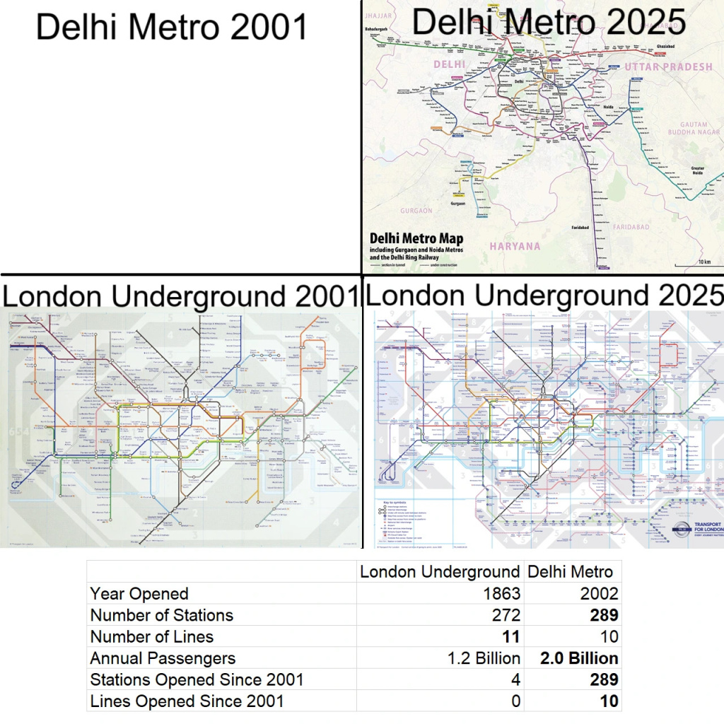
    London Underground vs Delhi Metro LU-vs-Dehli-metro.jpg

    https://brilliantmaps.com/london-underground-vs-delhi-metro/


  • Moderators, Politics Moderators, Paid Member Posts: 43,858 Mod ✭✭✭✭Seth Brundle


    I'm trying to locate many of these places and need some help.
    I see the following (using the rivers to split the map into segments):

    Left side of map (left of what may be the Dodder):

    • can't read
    • B. Ibb???
    • Ballinascorney?
    • Knockyn?
    • Tymon
    • Karaldyrany
    • Remyne
    • Donnybrook
    • S Cort?
    • Merrion
    • B. Wogan?
    • Newton?
    • ???
    • Cranedonkin?
    • Noneton?
    • Bremore?
    • Longnon?
    • Roch?
    • S. Bonets Ile = Dalkey island

    Next section:

    • Saggart
    • Belgard
    • Tallaght
    • Ca???
    • Crumlin
    • Ra???

    The next grouping:

    • Kilmactalway (townland near Casement Aerodrome)
    • Clondalkin
    • Ballydowd (Lucan)?
    • Ballyfermot
    • Drimnagh
    • Kilmainham

    Next:

    • Luttrellstown
    • Porterstown
    • Castleknock

    Next:

    • Kilsalaghan
    • Mulhuddart
    • M???
    • D???
    • Glasnevin
    • Cloghran
    • Drumcondra
    • Swords
    • Feltrim
    • Seatown
    • Killester
    • Clontarf
    • Malahide
    • Balgriffin
    • Robswalls
    • C. Carth???

    Next (top right):

    • Clon? (can't read full name)
    • Kithaster?
    • Cabelston?

    Last segment:

    • Lissenhall
    • Donabate
    • Turvey
    • Corballis
    • Lanestown


  • Registered Users, Registered Users 2 Posts: 73,783 ✭✭✭✭L1011


    Few of the ??? ones or ones with wildly misspelled on the map names: Knocklyon. Simmonscourt. Ballyogan for Ballywogan I'd guess. Ballydowd is a part of Lucan.


  • Moderators, Category Moderators, Arts Moderators, Sports Moderators, Paid Member Posts: 53,854 CMod ✭✭✭✭magicbastarder


    Cabelston (between the broadmeadow and the ward) is mentioned in one or two google hits, but others are coming up blank for me, though that may be a spelling issue; Cabelston is mentioned in the link below, and this seems to contain a list of a lot of towns/townlands contemporaneous with the map (the author is listed as having lived from 1552 to 1629) so others may also be there.

    the town west (well, north on that map!) of Cabelston seems to be 'Kilhaster' and there's a Kilhaste in Dublin on the list too.

    https://quod.lib.umich.edu/e/eebo/A61053.0001.001/1%3A47?rgn=div1;view=fulltext


  • Moderators, Category Moderators, Arts Moderators, Sports Moderators, Paid Member Posts: 53,854 CMod ✭✭✭✭magicbastarder


    Kilsalaghan

    Mulhuddart

    M???

    D???

    i'd have read the M entry as Midway - there's a Chapelmidway not far from there; right about where St. Margaret's golf club is.

    The D is Donesoghk.

    C. Carth???

    there's a 'Carth, Dublin. C' mentioned in that list - not sure what the C refers to. a church?


  • Advertisement
  • Registered Users, Registered Users 2 Posts: 1,615 ✭✭✭Sconsey


    Elizabeth line opened in 2022, with 10 new stations. If they missed that you have to wonder what other stats are wrong.


  • Registered Users, Registered Users 2 Posts: 4,190 ✭✭✭Brief_Lives


    Motorways of the world (stolen from Reddit)

    image.png


  • Registered Users, Registered Users 2 Posts: 31,731 ✭✭✭✭zell12


  • Registered Users, Registered Users 2, Paid Member Posts: 27,954 ✭✭✭✭Peregrinus


    NZ doesn't have any motorways!

    (Some stretches of state highways are built to motorway standards, more or less, but they are not officially designated as motorways, and they can switch between motorway and dual carriageway design without warning.)


  • Registered Users, Registered Users 2, Paid Member Posts: 4,933 ✭✭✭Rawr


    It's also not a very fair comparison. The London system is the probably the world's oldest metro system in continious operation. (The first line started running during the American Civil War ffs!) It has had to adapt to and fit into an emense warren of buildings and rivers and all other kinds of challenges. It's impressive that they can upgrade it at all, which they still manage to do.

    The Delhi Metro had more flexibity when it came to taking over land, and a lot of the lines appear to be running on elevated platforms, making a lot of the construction uniform and much faster to do compared to within London. There's also the whole thing of Delhi not having a metro at all until 2001 while using overloaded Victorian era trunk railines for most of the commuter traffic.


  • Advertisement
  • Registered Users, Registered Users 2 Posts: 775 ✭✭✭minggatu


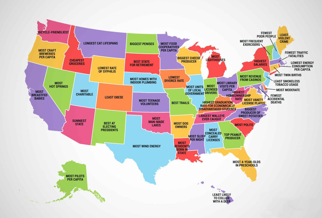
    What every U.S. state is best at

    GxnszznWMAAgM0H.jpg

    https://x.com/amazingmap/status/1952852292543152442/photo/1


  • Moderators, Politics Moderators, Paid Member Posts: 43,858 Mod ✭✭✭✭Seth Brundle


    Yeah, my formatting was all over the place (trying to get work done at the same time as doing this more important task!), but it was more for the ??? ones

    Some of them are strange inclusions from a relatively modern perspective. The Ballydowd one for example - why was it placed on Mercator's 1628 map - the OSI 25" map (which was three hundred years after) shows that the Ballydowd townland would have been less important that neighbouring Lucan village, Edmonsbury, Woodville, Glebe, Fonthill, Quarryvale, etc.


  • Registered Users, Registered Users 2, Paid Member Posts: 14,765 ✭✭✭✭josip


    This wrecks my head, especially because the non-motorway roads are nearly always in the opposite colour.

    And quite often the next city you're going to will have a motorway and non-motorway alternatives signed.

    Satnav is invaluable.


  • Moderators, Category Moderators, Arts Moderators, Sports Moderators, Paid Member Posts: 53,854 CMod ✭✭✭✭magicbastarder


    it's slightly irritating that logainm has info for old town names, but the main search option can only find the current town names. e.g. cornstown was one i checked recently:

    https://www.logainm.ie/en/16819

    you can see that 'historical references' lists the variations over the years, going back six centuries - but if you search for 'Cordanstowne' in the search bar, the search results are empty.


  • Registered Users, Registered Users 2 Posts: 7,067 ✭✭✭Badly Drunk Boy


    Mulhuddart

    M???

    D???

    Glasnevin

    Is D??? = Dunsoghly, even though it looks like Donesoghk?


  • Registered Users, Registered Users 2 Posts: 775 ✭✭✭minggatu


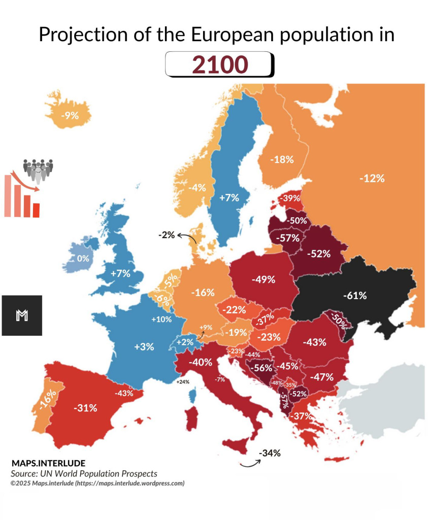
    Projection of the European population in 2100 uaq5a1zhekhf1.jpeg


  • Registered Users, Registered Users 2 Posts: 4,190 ✭✭✭Brief_Lives


    least likely to collide with a deer… brilliant..


  • Registered Users, Registered Users 2 Posts: 8,059 ✭✭✭Gaspode


    Could it be Dunsink? Or a variant of nearby Dunsinea, home of the Rathborne candle-making family.


  • Moderators, Science, Health & Environment Moderators Posts: 5,464 Mod ✭✭✭✭spacetweek


    It’s interesting that except for Spain and Italy, most of Western Europe will not have changed noticeably by then, but Eastern Europe and especially south east Europe will have suffered catastrophic declines. What’s even worse for the Ukraine is that the population will be 61% down on current levels, but current levels are already way less than they were compared to communist times. The country’s population has been in freefall ever since the end of that period.

    Ireland’s 0% change is not bad for a country of our size and peripheral location.
    It’s worth noting that nearly all the decline you see in that map will be absorbed by rural villages many of which will be completely abandoned. Big cities will continue to grow. In fact as a population enters a doom loop, with less and less people every year, the remaining people are more likely to go in big behind a few remaining places that are seen as still being economically dynamic, which means major cities. So even in 2100 in a country with a huge decline such as Lithuania or Bosnia, I would still expect their cities to be pretty big and possibly still continuing to grow.


  • Moderators, Sports Moderators Posts: 7,504 Mod ✭✭✭✭cdeb


    Well one of the issues with Ireland and the west of course is who is going to be living here in 2100 - what culture will predominate then and what will that mean for society, including how we align internationally.

    And in the east, the major concern I think has to be around safety of the EU in general. Ukraine/Poland/the Baltics with only half the population would surely be much more susceptible to a Russian invasion than at present. I think Europe needs a strong Ukraine for example, and the chart shows the exact opposite. That chart to me is akin to an empire crumbling at its edges.

    There's arguably something positive for the idea that population starts to centre around big cities and nature gets a chance to recover outside of them - although farming and food supply will still be an issue. I don't think it'd be a good idea to lose food security in such a turbulent time for example.


  • Advertisement
  • Registered Users, Registered Users 2 Posts: 1,389 ✭✭✭Sigma101


    The 0% change for Ireland is a little misleading. The CSO projects that the Irish population may grow up to 7 million in 2057 and would start to decline from that point on. A 0% change would imply 28% drop in the Irish population in the 43 years to 2100. In other words, we will encounter similar depopulation issues as eastern Europe, but just a little later. With population it's always better to look at trends than individual data points. I would argue that trends are poorly represented in a map like this.


  • Registered Users, Registered Users 2 Posts: 78,784 ✭✭✭✭Victor


    Trying to predict population growth 75 years into the future is a fools game.


  • Moderators, Science, Health & Environment Moderators Posts: 5,464 Mod ✭✭✭✭spacetweek


    Yep, agreed. Globally even by 2100 the middle East and Africa will still have strongly growing populations and my guess is in Europe, rather than suffer massive losses in working age people we will have made our peace with the idea of having lots of Africans and Muslims in our societies and they will prop up our populations in a major way.

    I don’t want to speculate how that will work in practice, like if they will be guest workers or permanent residents, but it doesn’t mean a radical change in European culture as long as permanent residents are integrated property. There is certainly still a fair bit of work left in that respect.


  • Registered Users, Registered Users 2 Posts: 493 ✭✭Mullinabreena


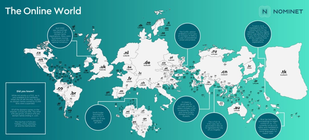
    Domain name map of the world. The map is out of date as .tk hasn't as many websites anymore. Its was very popular in the noughties. The Americans mainly use .com rather than. Us

    1000042481.jpg


  • Moderators, Recreation & Hobbies Moderators, Science, Health & Environment Moderators, Technology & Internet Moderators Posts: 95,786 Mod ✭✭✭✭Capt'n Midnight


    image.png

    https://xkcd.com/195/ very old map of the interweb

    image.png

    https://observablehq.com/%40vasturiano/hilbert-map-of-ipv4-address-space 2023

    image.png

    back in 2007 https://iepg.org/2007-12-ietf70/3dheatmaps.pdf


  • Moderators, Recreation & Hobbies Moderators, Science, Health & Environment Moderators, Technology & Internet Moderators Posts: 95,786 Mod ✭✭✭✭Capt'n Midnight


    image.png

    https://xkcd.com/3122/


    Title text: During the most recent glacial maximum, it's believed that land bridges extended from the surfaces and connected several of the spheres together.


  • Moderators, Social & Fun Moderators, Paid Member Posts: 13,863 Mod ✭✭✭✭JupiterKid


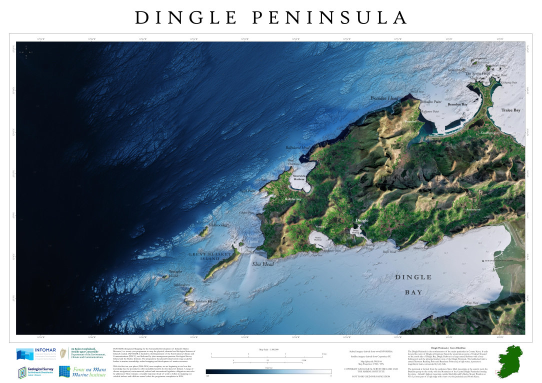
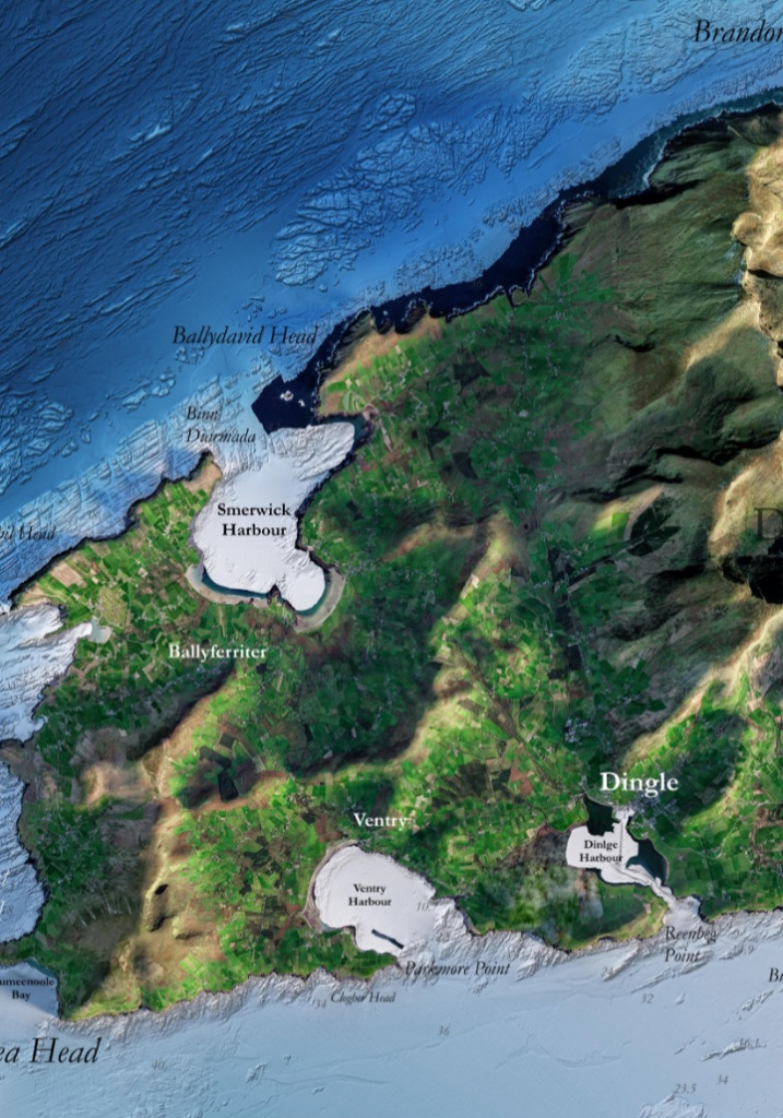
    New GSI Blue Scale Series topographic/bathymetry map of Dingle Peninsula in Kerry

    4_Dingle_Peninsula.jpeg

    The level of land cover detail when you zoom in is just stunning.

    Screenshot_20250806_210848_Gallery.jpg


  • Moderators, Social & Fun Moderators, Paid Member Posts: 13,863 Mod ✭✭✭✭JupiterKid


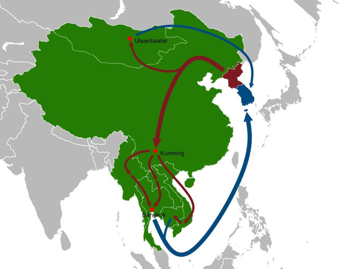
    Routes of escape and defection from North Korea to South Korea

    FB_IMG_1754520034037.jpg


  • Moderators, Social & Fun Moderators, Paid Member Posts: 13,863 Mod ✭✭✭✭JupiterKid


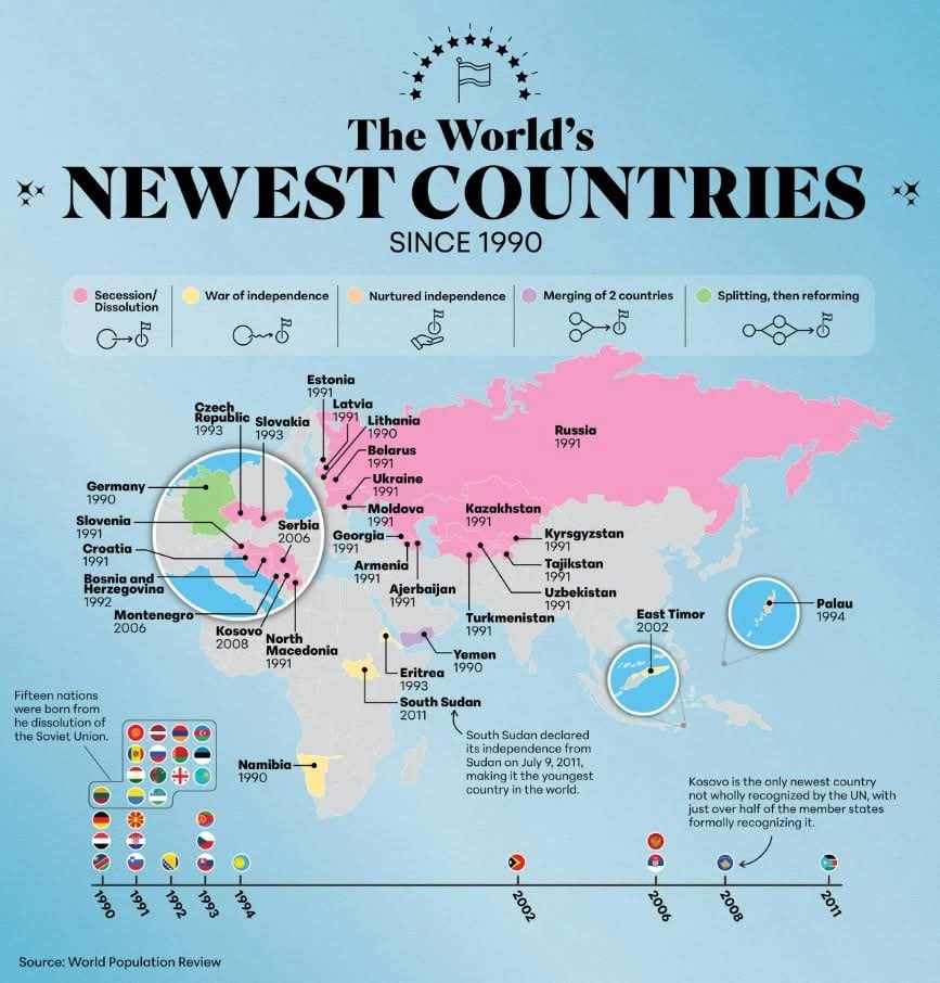
    Countries created (or reunited in the case of Germany) since 1990

    FB_IMG_1754580276509.jpg


  • Advertisement
  • Moderators, Sports Moderators Posts: 7,504 Mod ✭✭✭✭cdeb


    Given how high-carbon the sort of immigration you mention is, the map of Europe in 2100 if we go down that route (which is the route we are going down) would look more like this -

    image.png

    That's based on projected sea level rises as carbon emissions melt the ice caps

    Post edited by cdeb on


Advertisement