Advertisement
If you have a new account but are having problems posting or verifying your account, please email us on hello@boards.ie for help. Thanks :)
Hello all! Please ensure that you are posting a new thread or question in the appropriate forum. The Feedback forum is overwhelmed with questions that are having to be moved elsewhere. If you need help to verify your account contact hello@boards.ie

Interesting Maps

1319320322324325335

Comments

  • Registered Users, Registered Users 2 Posts: 613 ✭✭✭minggatu


    Sex Ratio in Europe sex-ratio-in-europe-v0-wwljze2iczpe1.jpg


  • Registered Users, Registered Users 2 Posts: 5,702 ✭✭✭yagan


    Ah come on, there's loads who tick the RCC box but never set foot in a church. Some answer their census form with aspirations rather than facts.


  • Moderators, Recreation & Hobbies Moderators, Science, Health & Environment Moderators, Technology & Internet Moderators Posts: 94,849 Mod ✭✭✭✭Capt'n Midnight


    image.png

    ,,


  • Registered Users, Registered Users 2 Posts: 9,144 ✭✭✭Gloomtastic!


    During the famine the sea, rivers and lakes were full of fish but the Catholic Church forbid their flocks from eating them. True/false?


  • Registered Users, Registered Users 2 Posts: 14,747 ✭✭✭✭josip


  • Advertisement
  • Moderators, Recreation & Hobbies Moderators Posts: 22,601 Mod ✭✭✭✭Brian?


    completely false. You can’t feed a population of 9m on fish. They need a ready supply of a stable carbohydrate.

    Why would the church forbid eating fish? They ate it every Friday at the time.

    they/them/theirs


    The more you can increase fear of drugs and crime, welfare mothers, immigrants and aliens, the more you control all of the people.

    Noam Chomsky


  • Registered Users, Registered Users 2 Posts: 613 ✭✭✭minggatu


    Wild West vs Wild East: American vs Russian Expansion 1300 to 1914

    us-american-vs-russian-expansion.jpg

    Map created by StoneColdCrazzzyThe map above contrasts the growth of the Russian Empire between 1300 and 1914 with that of the United States from 1776 to 1914 using a similar colour scheme for each decade.

    You can see each map in more detail below, followed by an explanation.

    https://brilliantmaps.com/wild-west-vs-wild-east/#more-17876


  • Registered Users, Registered Users 2 Posts: 793 ✭✭✭Beanntraigheach


    Are you serious? You actually believe this is credible?!
    Where did you come across such a ludicrous claim?

    Also, why respond to my post with it?


  • Registered Users, Registered Users 2 Posts: 613 ✭✭✭minggatu


    Map & Timeline Of The Seven Wonders of the Ancient World Ancient_seven_wonders_timeline.svg_(1).jpg

    Map created by cmglee, Juandamec, Kirill Borisenko, Flappiefh, Nicolas M. PerraultThe map above shows the locations and timeline of existence of the Seven Wonders of the Ancient World by CMG Lee.

    This is shown alongside the approximate lifetime of Philo of Byzantium, who documented them and was alive when they all existed simultaneously.

    And at the bottom you can see the relative height of each of them.

    Dates in bold green indicate construction, while dates in dark red indicate destruction.

    Here’s more about them:

    https://brilliantmaps.com/seven-wonders-of-the-ancient-world/


  • Registered Users, Registered Users 2 Posts: 16,632 ✭✭✭✭cj maxx


    I disagree . There are several Gaeltacht in Ireland where Irish is the language used . I know that the people are also fluent in English but Irish is their conversational language . Most of native Welsh speakers were taken over in the 14’hundreds very much a niche language .
    Even though you heard them speaking in Welsh yo cannot know the level they are speaking . I doubt that there are any Welsh people fluent in conversational Welsh , as opposed to say Donegal lads who speak it as their native language.


  • Advertisement
  • Moderators, Sports Moderators Posts: 7,415 Mod ✭✭✭✭cdeb


    I mean, if you want to get into supposing and making stuff up, then sure, fire ahead.

    I've given a link showing 300k daily Welsh speakers, four times the amount of daily Irish speakers despite half the population. You've just supposed there's none, based on no evidence at all.

    You're hardly likely to hear people speaking Welsh in public who are barely able to speak the language. That doesn't make any sense. And even without knowing what's being said, you can tell fluent speakers from non-fluent ones by the fluency of their speech (the clue is in the word); non-fluent speakers of any language will - literally by definition - pause quite regularly to search for a word or an equivalent word for example.


  • Registered Users, Registered Users 2 Posts: 30,276 ✭✭✭✭zell12


    Library building deliberately built on US/Canada border 1905. Town services used by both countries. US to close off access

    A thick black line runs beneath the seats of the opera house and diagonally across the center of the library's reading room to mark border. The stage and half of the seats are in Canada; the remainder of the opera hall is in the US. The building has different postal codes (93 Caswell Avenue, 05830 and 1 rue Church, J0B 3E2) and different telephone area codes (+1-802-873-3022 and +1-819-876-2471) in its two respective countries.

    Interesting listen https://www.podbean.com/media/share/dir-4y87p-1e53d964 and Wiki

    image.png


  • Registered Users, Registered Users 2 Posts: 72,774 ✭✭✭✭L1011


    Most of the land area of the Donegal Gaeltacht is not a Gaeltacht anymore. Not sure the same drop has happened in other areas, but you could spend a week in Dungloe and not hear aon focail.


  • Registered Users, Registered Users 2 Posts: 40,922 ✭✭✭✭ohnonotgmail


    I know anecdotes are not data but I have spent quite a bit of time on customer sites in Wales. In north Wales, Conwy, Ceredigion, Blaenau Gwent etc the normal language for a lot of the young people was welsh. Not so much among older people. Now I can't comment on their fluency as I don't speak the language but they were using it as their first language in work so they must have been pretty fluent. You even hear it used by customers and staff in shops. I wouldn't get too bogged down by the fluency rates from the census. That 38% figure for Ireland is just complete nonsense.


  • Registered Users, Registered Users 2 Posts: 613 ✭✭✭minggatu


    Map of Europe 13 million years ago map-of-europe-13-million-years-ago-v0-e1lw5pvxp4qe1.jpg

    https://www.reddit.com/r/MapPorn/comments/1jgv0jb/map_of_europe_13_million_years_ago/


  • Registered Users, Registered Users 2 Posts: 16,632 ✭✭✭✭cj maxx


    That’s good news . I’m going off Welsh girls I knew in the 90’s . They had no Welsh apart from hello and goodbye . Pidgin Welsh


  • Moderators, Recreation & Hobbies Moderators, Science, Health & Environment Moderators, Technology & Internet Moderators Posts: 94,849 Mod ✭✭✭✭Capt'n Midnight


    image.png

    ..


  • Registered Users, Registered Users 2 Posts: 613 ✭✭✭minggatu


    Android vs iOS in Europe m8tyyh1xny8b1.jpg


  • Moderators, Social & Fun Moderators Posts: 13,547 Mod ✭✭✭✭JupiterKid


    Satellite images of the beautiful Plaza Mayor in Madrid, Spain.

    FB_IMG_1742616731203.jpg SpY_12.jpg


  • Moderators, Social & Fun Moderators Posts: 13,547 Mod ✭✭✭✭JupiterKid


    The USA categorised by the Beach Boys in 1966 😁

    FB_IMG_1742616629048.jpg


  • Advertisement
  • Moderators, Social & Fun Moderators Posts: 13,547 Mod ✭✭✭✭JupiterKid


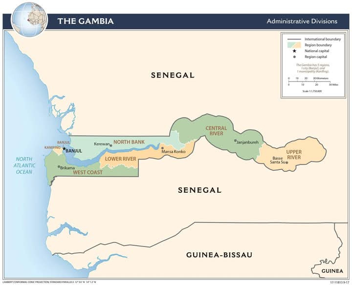
    The Gambia in west Africa.

    FB_IMG_1742609634364.jpg

    A linear shaped country due to its borders being determined by a constant distance from the Gambia River.


  • Registered Users, Registered Users 2 Posts: 30,276 ✭✭✭✭zell12


    Ennis - why is there a large peace symbol therein or what is it?

    image.png image.png image.png


  • Registered Users, Registered Users 2 Posts: 29,646 ✭✭✭✭Quazzie


    Unless you think it's only Irish people who do that and not Welsh people the same factor of error would be on both sides.


  • Registered Users, Registered Users 2 Posts: 4,630 ✭✭✭Rawr


    Maybe the farmer there really really wants a Mercedes and is hoping that a Google Map user (or maybe Aliens?) will get one from him? :P


  • Moderators, Politics Moderators Posts: 42,866 Mod ✭✭✭✭Seth Brundle


    WW2 Éire Navigational Aid & Neutrality Markers.

    FB_IMG_1742725478125.jpg

    https://www.facebook.com/share/p/1AGXBcz1vX/


  • Registered Users, Registered Users 2 Posts: 613 ✭✭✭minggatu


    Map of Earth during the last Glacial maximum (29,000-19,000 years ago)

    cwjgza7f1fqe1.jpeg

    https://www.reddit.com/r/MapPorn/comments/1jhw80t/map_of_earth_during_the_last_glacial_maximum/


  • Registered Users, Registered Users 2 Posts: 613 ✭✭✭minggatu


    Estimated world population distribution for -3000, 1000, 1900, 2025

    cprp5tew9gqe1.png

    https://www.reddit.com/r/MapPorn/comments/1ji0lw4/estimated_world_population_distribution_for_3000/


  • Moderators, Recreation & Hobbies Moderators, Science, Health & Environment Moderators, Technology & Internet Moderators Posts: 94,849 Mod ✭✭✭✭Capt'n Midnight


    image.png

    Sea level.

    image.png

    Dogerland

    image.png

    Sea level vs time , insert is water depth


  • Registered Users, Registered Users 2 Posts: 613 ✭✭✭minggatu


  • Advertisement
  • Moderators, Social & Fun Moderators Posts: 13,547 Mod ✭✭✭✭JupiterKid


    Distribution of castles in western Europe

    FB_IMG_1742704555285.jpg


Advertisement