Advertisement
If you have a new account but are having problems posting or verifying your account, please email us on hello@boards.ie for help. Thanks :)
Hello all! Please ensure that you are posting a new thread or question in the appropriate forum. The Feedback forum is overwhelmed with questions that are having to be moved elsewhere. If you need help to verify your account contact hello@boards.ie
Hi there,
There is an issue with role permissions that is being worked on at the moment.
If you are having trouble with access or permissions on regional forums please post here to get access: https://www.boards.ie/discussion/2058365403/you-do-not-have-permission-for-that#latest

Interesting Maps

12425272930169

Comments

  • Registered Users, Registered Users 2 Posts: 6,009 ✭✭✭Charles Babbage


    KevRossi wrote: »
    Map showing the shortest distance from every townland in Ireland to Dublin (O'Connell Bridge). Some body of work, not sure if it's auto generated, or done piece by piece.


    While most flows are logical along main routes, there is a rather strange flow ending in South Armagh between the N1 and N2. A data error perhaps?
    Perhaps it is distorted by all NI roads having a 60Mph speed limit although you would be unwise to approach that speed on many of them.


  • Registered Users, Registered Users 2 Posts: 6,009 ✭✭✭Charles Babbage


    Height in Europe and basketball wins

    main-qimg-10fda366e96b76eabbf9cf11193043c5


  • Moderators, Recreation & Hobbies Moderators, Science, Health & Environment Moderators, Technology & Internet Moderators Posts: 93,127 Mod ✭✭✭✭Capt'n Midnight


    Victor wrote: »
    Based on the M17 and M40, it is at least partially based on speed limits. While www.openstreetmap.org has speed limits for most main roads, it won't have them for many minor roads.


    shutterstock_9011104-390x285.jpg

    But all minor roads are 80Kph :cool:


  • Registered Users, Registered Users 2 Posts: 10,301 ✭✭✭✭gerrybbadd


    Another interesting map


  • Registered Users, Registered Users 2 Posts: 249 ✭✭SixtaWalthers


    See the states of peace map :D

    13104da92504b57c5be2634b68b8a336.png


  • Registered Users, Registered Users 2 Posts: 6,176 ✭✭✭1huge1


    gerrybbadd wrote: »
    Another interesting map

    Theres so much going on in that, but two things jump out at me.

    All the Baltic States trying their best to hold back the advance of Russia while Finland is just having a few beers and using Russia to rest its arm on? :D:D

    As for Ireland, old tiger needs work? thought we were at full employment (pre covid).

    Really interesting map


  • Registered Users, Registered Users 2 Posts: 78,537 ✭✭✭✭Victor


    1huge1 wrote: »
    As for Ireland, old tiger needs work? thought we were at full employment (pre covid).
    2016 map.


  • Registered Users, Registered Users 2 Posts: 4,498 ✭✭✭KevRossi


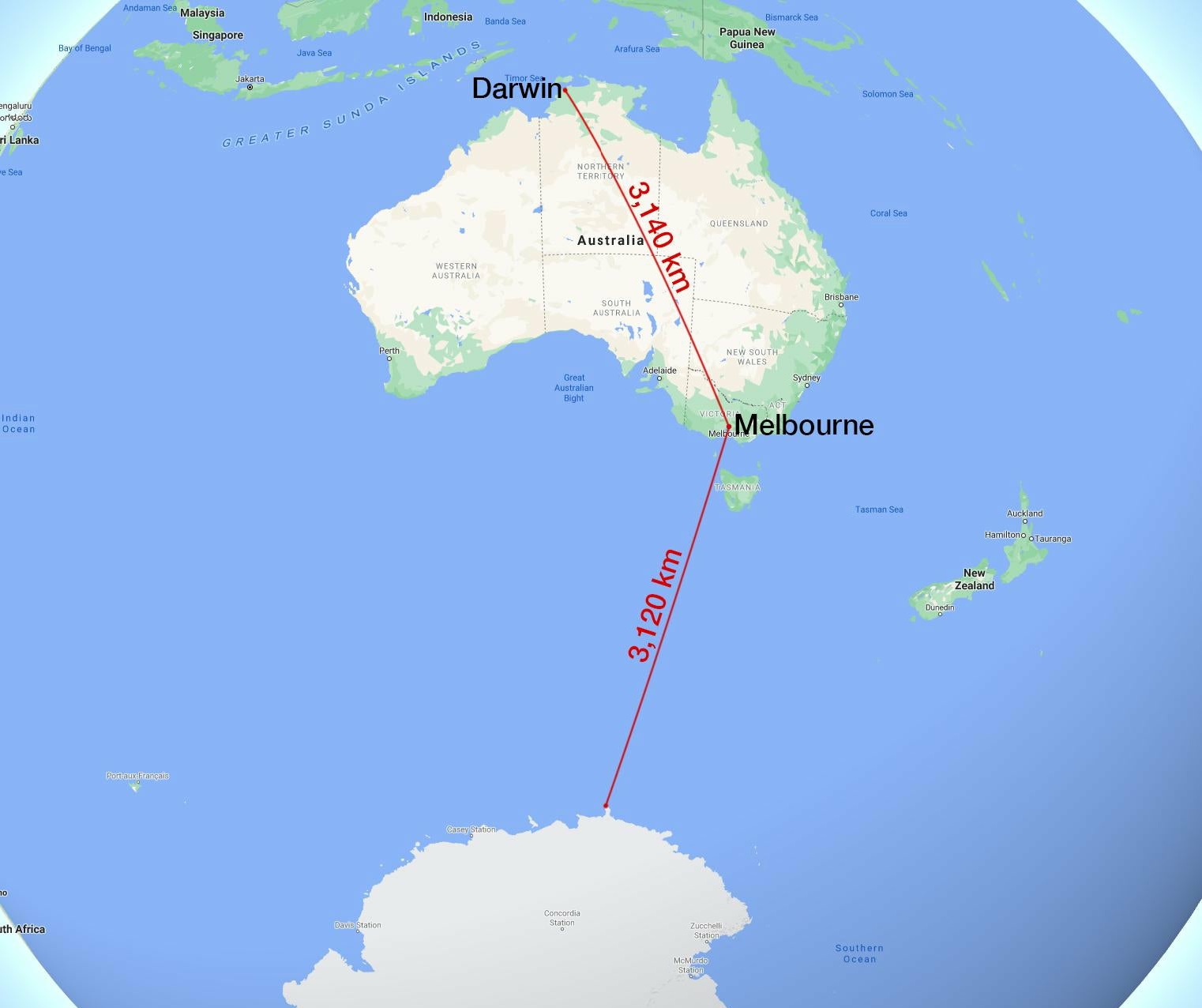
    Melbourne is nearer to Antarctica than it is to Darwin.

    Ehq9noOXgAA_U22?format=jpg&name=large


  • Registered Users, Registered Users 2 Posts: 4,498 ✭✭✭KevRossi


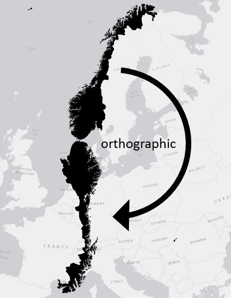
    Swivel Norway on it's southernmost point and the top will reach Barcelona or Rome.

    blog2.jpg


  • Registered Users, Registered Users 2 Posts: 17,819 ✭✭✭✭peasant


    KevRossi wrote: »
    Map showing the shortest distance from every townland in Ireland to Dublin (O'Connell Bridge).

    Very interesting details on this map.

    In the circle is the area just outside Sligo where neighbours divide between driving through the North or the Republic to get to Dublin

    526100.JPG


  • Advertisement
  • Banned (with Prison Access) Posts: 9,078 ✭✭✭IAMAMORON


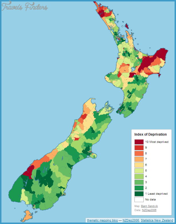
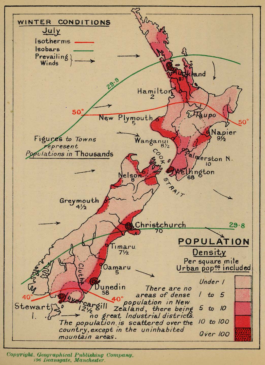
    Look at that map of Australasia, New Zealand really is in the middle of nowhere. I reckon that's where they are all hiding away, how could you know? Look where Dunedin is. I would say you could do you want down there if you had half a clue.

    Q5EHAL3VRVGKHHAG6YJHZRIME4.pngpopulation-map-of-new-zealand_2.png

    I reckon there are clowns there that have never even been to the other island yet, it just seems like that type of place really.

    new_zealand_pop_density_1918.jpg


  • Registered Users, Registered Users 2 Posts: 21,808 ✭✭✭✭Water John


    Actually New Zealanders do move around quite a bit. They have no problem hopping in the car and driving 5/6 hours. The two ferries between the two islands do massive business. Maybe the poor in each city don't move that much. But every family has an old car and in NZ they are old.


  • Banned (with Prison Access) Posts: 9,078 ✭✭✭IAMAMORON


    Water John wrote: »
    Actually New Zealanders do move around quite a bit. They have no problem hopping in the car and driving 5/6 hours. The two ferries between the two islands do massive business. Maybe the poor in each city don't move that much. But every family has an old car and in NZ they are old.

    i would love to read about ancient north south rivalries, I mean ancient ones now, not just the Scottish plantation stuff.

    IwiMap.png2d2e8adefe4b35668d05a67fcbe69c67.jpgmain-qimg-b534535592173406fad850241538a545-c

    Seems peculiar that there is more tribal activity on the north island as opposed the south island?


  • Registered Users, Registered Users 2 Posts: 21,808 ✭✭✭✭Water John


    Don't know the back history but the south would fairly mountainous and difficult to travel over. The earliest inhabitation of NZ they believe was around 1250 AD.


  • Registered Users, Registered Users 2 Posts: 17,000 ✭✭✭✭astrofool


    KevRossi wrote: »
    Swivel Norway on it's southernmost point and the top will reach Barcelona or Rome.

    blog2.jpg

    Billy Connolly said it was Morocco!

    https://vimeo.com/24340940


  • Registered Users, Registered Users 2 Posts: 14,275 ✭✭✭✭josip


    IAMAMORON wrote: »
    Seems peculiar that there is more tribal activity on the north island as opposed the south island?


    They're fairly different climates.
    I don't have any facts , but just from living there, and driving from Cape Reinga to Bluff, once you go south of Picton it just gets colder and more upland.
    On the West coast it's incredibly wet and the midges would eat ya.
    The bottom of the South is bleak and depressing.
    One of the dourest people I ever met was from Invercargill.


  • Registered Users, Registered Users 2 Posts: 40,573 ✭✭✭✭ohnonotgmail


    Water John wrote: »
    Don't know the back history but the south would fairly mountainous and difficult to travel over. The earliest inhabitation of NZ they believe was around 1250 AD.

    the migration to the south island is much later. Late 17th century or thereabouts.


  • Registered Users, Registered Users 2 Posts: 21,808 ✭✭✭✭Water John


    The top of the South Island is very pleasant and sheltered, moreso than Wellington, (the windiest capital in the world). This is where the fruit and wines comes from. As Josip says gets fairly unforgiving south of that.


  • Banned (with Prison Access) Posts: 9,078 ✭✭✭IAMAMORON


    josip wrote: »
    One of the dourest people I ever met was from Invercargill.

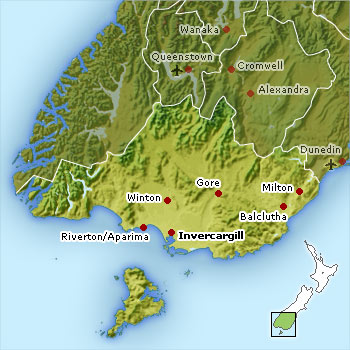
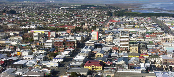
    Street plan of alleged most dourest corner of New Zealand.

    best-western-colonial-motel-map.gifresizess_4e5de956593354e5de9567801c4e5de956a73d7Southland%20Map.jpgInvercargill-banner-560x250.jpg

    Thanks for the heads up btw, always good to know what to take off the bucket list.

    Be some craic if they had a secret monster living in a lake nearby.


  • Advertisement
  • Moderators, Recreation & Hobbies Moderators, Science, Health & Environment Moderators, Technology & Internet Moderators Posts: 93,127 Mod ✭✭✭✭Capt'n Midnight


    70a872522bca6ce92c46f58f1fad67df.jpg


  • Registered Users Posts: 842 ✭✭✭Hego Damask


    astrofool wrote: »
    Billy Connolly said it was Morocco!

    https://vimeo.com/24340940

    Beat me to it !! :D -- edit , actually if you naively do the distance on a 2d map it does go to Morocco, didn't take the polar stretch they do for 2d maps into account...


  • Registered Users Posts: 842 ✭✭✭Hego Damask


    70a872522bca6ce92c46f58f1fad67df.jpg

    I love comparisons like this, I always thought Sydney was similar to Barcelona in proximity to equator wise ... Sydney is far closer, would be close to mid sahara in the northern hemisphere.


  • Registered Users, Registered Users 2 Posts: 21,808 ✭✭✭✭Water John


    It really shows up the notion often told to farmers that farming in NZ is similar to here.
    Now it has a more temperate climate than Continental Europe, but I was in NZ for the month of April last year, which is comparable with our October. We were wearing sun cream and it was between 18/21C every day.


  • Registered Users, Registered Users 2 Posts: 20,132 ✭✭✭✭cnocbui


    Ireland is at the same latitude as the southern end of Hudson bay in Canada - about where Polar Bear Provincial Park is. If the Gulf Stream ever shuts down...


  • Moderators, Recreation & Hobbies Moderators, Science, Health & Environment Moderators, Technology & Internet Moderators Posts: 93,127 Mod ✭✭✭✭Capt'n Midnight


    cnocbui wrote: »
    If the Gulf Stream ever shuts down...
    We will still be on the East side of an Ocean.


  • Advertisement
  • Banned (with Prison Access) Posts: 9,078 ✭✭✭IAMAMORON


    Water John wrote: »
    It really shows up the notion often told to farmers that farming in NZ is similar to here.
    Now it has a more temperate climate than Continental Europe, but I was in NZ for the month of April last year, which is comparable with our October. We were wearing sun cream and it was between 18/21C every day.

    if it gets too warm they can always head down to Invercargill.

    " I wish I was in Innnn Ver Car Gill " , sung to the tune of "Carrickfergus"


  • Registered Users, Registered Users 2 Posts: 21,808 ✭✭✭✭Water John


    Think there is an air monitoring base station there as there is no other land/pollution at that latitude around the world.


  • Registered Users, Registered Users 2 Posts: 20,132 ✭✭✭✭cnocbui


    We will still be on the East side of an Ocean.

    Hair splitting?
    The problem lies with the ocean current known as the Gulf Stream, which bathes the UK and north-west Europe in warm water carried northwards from the Caribbean. It is the Gulf Stream, and associated currents, that allow strawberries to thrive along the Norwegian coast, while at comparable latitudes in Greenland glaciers wind their way right down to sea level. The same currents permit palms to flourish in Cornwall and the Hebrides, whereas across the ocean in Labrador, even temperate vegetation struggles to survive. Without the Gulf Stream, temperatures in the UK and north-west Europe would be five degrees centigrade or so cooler, with bitter winters at least as fierce as those of the so-called Little Ice Age in the 17th to 19th centuries.


  • Registered Users Posts: 2,108 ✭✭✭Lirange


    cnocbui wrote: »
    If the Gulf Stream ever shuts down...

    We’d basically be Iceland sans the volcanoes.


  • Registered Users, Registered Users 2 Posts: 5,942 ✭✭✭topper75


    The engine that drives the gulf stream is the sun beating down on the gulf of Mexico coupled with the earth rotating. If that ever shut down, I would think it was Goodnight Irene anyway.


  • Advertisement
  • Registered Users, Registered Users 2 Posts: 21,808 ✭✭✭✭Water John


    The sun is also generating 5 hurricanes in the Atlantic ATM.
    https://www.nhc.noaa.gov/gtwo.php


  • Registered Users, Registered Users 2 Posts: 4,498 ✭✭✭KevRossi


  • Registered Users, Registered Users 2 Posts: 5,942 ✭✭✭topper75


    It is the sun indeed - fair play to it. I don't know if there ever was a year without hurricanes forming out there. But I suppose there were never huge amounts of humans living on the coasts they slam into until now. And certainly not the 24-hour news bulletins showing us the menacing satellite shots. That part is all new.


  • Registered Users, Registered Users 2 Posts: 21,808 ✭✭✭✭Water John


    It's only the second time 5 hurricanes at the same time has been recorded.


  • Registered Users, Registered Users 2 Posts: 12,637 ✭✭✭✭OldGoat


    topper75 wrote: »
    The engine that drives the gulf stream is the sun beating down on the gulf of Mexico coupled with the earth rotating. If that ever shut down, I would think it was Goodnight Irene anyway.

    Ocean currents are also driven by a thermohaline (temp and salinity) process. It's one of the big worries with global warming that the release of fresh water at the polar ice caps will dilute the sea water, reducing it's saltiness in the northern regions and thus causing the gulf stream to invert it's direction.
    Cheery thought. :)

    I'm older than Minecraft goats.


  • Registered Users, Registered Users 2 Posts: 5,942 ✭✭✭topper75


    Followed by immediate self-correction though, right? As in the absence of the warming current leading to colder northern seas and reversal of any winter ice-melting process?


  • Moderators, Recreation & Hobbies Moderators, Science, Health & Environment Moderators, Technology & Internet Moderators Posts: 93,127 Mod ✭✭✭✭Capt'n Midnight


    topper75 wrote: »
    Followed by immediate self-correction though, right? As in the absence of the warming current leading to colder northern seas and reversal of any winter ice-melting process?
    More fresh water means Arctic freezes over. Diverting water south was a Soviet era plan to green the deserts and fill the inland seas and make the Arctic saltier and so easier to navigate.


    kgsms95z89451.png
    https://i.redd.it/kgsms95z89451.png

    https://www.researchgate.net/publication/302888269_The_Siberian_Water_Transfer_Scheme


  • Registered Users, Registered Users 2 Posts: 22,382 ✭✭✭✭endacl


    Water John wrote: »
    It's only the second time 5 hurricanes at the same time has been recorded.

    :eek::eek::eek:The neutrinos have mutated!!!! :eek::eek::eek:


  • Registered Users, Registered Users 2 Posts: 20,132 ✭✭✭✭cnocbui


    topper75 wrote: »
    Followed by immediate self-correction though, right? As in the absence of the warming current leading to colder northern seas and reversal of any winter ice-melting process?

    Well yes, if you can call a plunge of 8° C lasting over a hundred years a 'correction', which is what happened 8,000 years ago: https://www.newscientist.com/article/dn13013-ancient-flood-brought-gulf-stream-to-a-halt/#

    Modern ice ages are accompanied by a shut down in the Gulf Stream/Atlantic conveyor/THC. That circulation system has been slowing and is currently 15% weaker than it was in the middle of the last century.


  • Registered Users, Registered Users 2 Posts: 5,942 ✭✭✭topper75


    cnocbui wrote: »
    Well yes, if you can call a plunge of 8° C lasting over a hundred years a 'correction', which is what happened 8,000 years ago: https://www.newscientist.com/article/dn13013-ancient-flood-brought-gulf-stream-to-a-halt/#

    Modern ice ages are accompanied by a shut down in the Gulf Stream/Atlantic conveyor/THC. That circulation system has been slowing and is currently 15% weaker than it was in the middle of the last century.

    But wouldn't such a plunge be mitigated by global warming today with all the CO2 being released by man?
    I mean water won't suddenly lose the ability to be heated by warmer air. You put water in a greenhouse, it gets warm fast.

    Every way you look at it - it self-corrects.


  • Advertisement
  • Registered Users, Registered Users 2 Posts: 9,598 ✭✭✭Padraig Mor


    Came across this yesterday - hopefully not posted previously. Major Roman roads in a Tube style map.

    526612.png

    Larger original:
    https://sashamaps.net/images/roman_roads_original.png?fbclid=IwAR3HhK74e6hRPCcq2AtXEOtIkDu975OaStw2THHkNDd1i765SE8aMgj5LsQ


  • Moderators, Music Moderators Posts: 12,668 Mod ✭✭✭✭iamstop


    cnocbui wrote: »
    Ireland is at the same latitude as the southern end of Hudson bay in Canada - about where Polar Bear Provincial Park is. If the Gulf Stream ever shuts down...

    I live in Winnipeg right now. We're 49.80 degrees north. Dublin is 53.34. Here in Winnipeg -40C in winter is not uncommon. Add wind chill to that and it's easily below -50.

    Layers are your only friend in those temps.


  • Registered Users, Registered Users 2 Posts: 3,376 ✭✭✭nc6000


    I like that Roman map, interesting that they never came to Ireland.


  • Registered Users, Registered Users 2 Posts: 40,573 ✭✭✭✭ohnonotgmail


    nc6000 wrote: »
    I like that Roman map, interesting that they never came to Ireland.

    they realised that the people were getting more scary the further west they went so decided to stop at Wales.


  • Registered Users, Registered Users 2 Posts: 20,132 ✭✭✭✭cnocbui


    nc6000 wrote: »
    I like that Roman map, interesting that they never came to Ireland.

    They were probably told the weather is like that place north of Hadrian's wall, but the inhabitant's aren't as chilled, and so they said quod irrumabo!


  • Moderators, Recreation & Hobbies Moderators, Science, Health & Environment Moderators, Technology & Internet Moderators Posts: 93,127 Mod ✭✭✭✭Capt'n Midnight


    nc6000 wrote: »
    I like that Roman map, interesting that they never came to Ireland.
    Maybe they did up near Rush

    Hibernia, the Land of Winter.


  • Registered Users, Registered Users 2 Posts: 3,950 ✭✭✭chooseusername


    nc6000 wrote: »
    I like that Roman map, interesting that they never came to Ireland.
    Veni, vidi, non vis


  • Registered Users, Registered Users 2 Posts: 4,498 ✭✭✭KevRossi


    Some maps about China

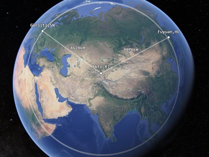
    1. The westernmost point of China is nearer to Germany than it is to the easternmost point of China. That's how big the place is.

    Eh6F4c-WAAE-9AG?format=jpg&name=small


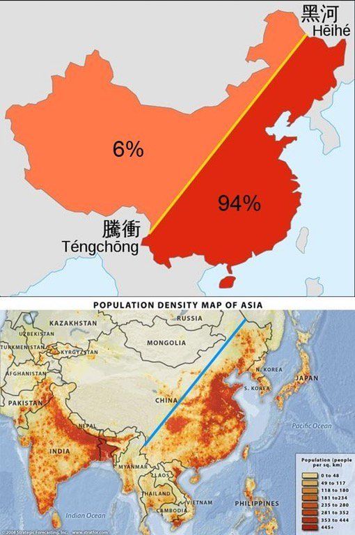
    2. Not all Chinese live in the same place... this map shows the population distribution of the country.

    D0DJbBEXcAA1GWx?format=jpg&name=900x900


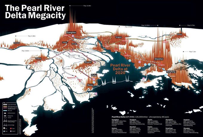
    3. Many of them live in the Pearl River Delta MegaCity, about 135,000,000. For reference the distance from Zhaoqing on the left, to Hong Kong on the right is about the same as Galway to Dublin.

    DuZ_ygpXgAAImbL?format=jpg&name=small

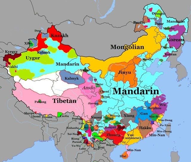
    4. They don't all understand each other, a map of languages of China, many of these are incomprehensible to each other.

    Dja7ACqXgAAFFsI?format=jpg&name=small

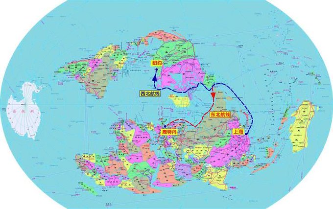
    5. This map shows the recommended route from China to New York or Rotterdam by sea. Avoids piracy, PITA customs and coast guards and lengthy queues and charges at the Suez and Panama canals. Due to climate change this route is navigable more months of the year than ever before.

    DvGZIa-WoAAnErt?format=jpg&name=small


  • Registered Users, Registered Users 2 Posts: 18,854 ✭✭✭✭silverharp


    its oversized so didnt imbed, not sure who its measured but interesting, some kind of measure of status or popularity of degrees in each country in europe

    https://i.redd.it/qq0icdj93ozz.png

    A belief in gender identity involves a level of faith as there is nothing tangible to prove its existence which, as something divorced from the physical body, is similar to the idea of a soul. - Colette Colfer


  • Advertisement
  • Registered Users, Registered Users 2 Posts: 40,573 ✭✭✭✭ohnonotgmail


    silverharp wrote: »
    its oversized so didnt imbed, not sure who its measured but interesting, some kind of measure of status or popularity of degrees in each country in europe

    https://i.redd.it/qq0icdj93ozz.png

    is it not showing the degree that each countries leader has? Or had as it shows medicine for Varadkar


Advertisement