Advertisement
If you have a new account but are having problems posting or verifying your account, please email us on hello@boards.ie for help. Thanks :)
Hello all! Please ensure that you are posting a new thread or question in the appropriate forum. The Feedback forum is overwhelmed with questions that are having to be moved elsewhere. If you need help to verify your account contact hello@boards.ie

Interesting Maps

12526283031340

Comments

  • Registered Users, Registered Users 2 Posts: 3,966 Brief_Lives
    ✭✭✭


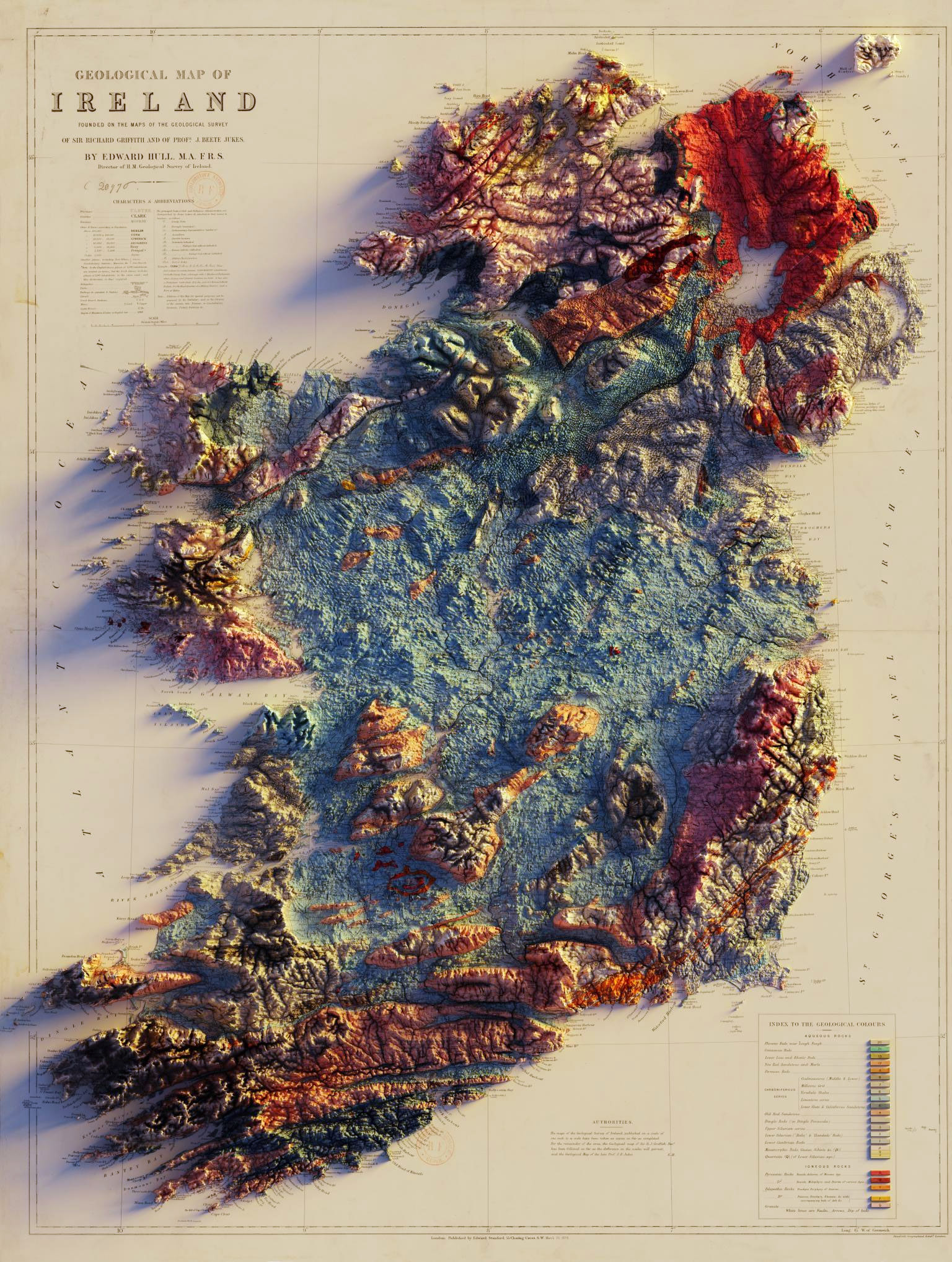
    Who did the 3D render? any link? Great image.


  • Moderators, Recreation & Hobbies Moderators Posts: 16,287 quickbeam
    Mod ✭✭✭✭


    ^^ Now my desktop picture. Lovely stuff.

    Wondered what that Island up the NE was. Checked Google Maps and it's actually Scotland (Mull of Kintyre). I'd never realised just how close Great Britain was to the island of Ireland.


  • Registered Users, Registered Users 2 Posts: 9,513 Shedite27
    ✭✭✭


    Who did the 3D render? any link? Great image.

    Looks like @geo_spatialist on Twitter is responsible. Per Twitter, he's currently redoing it in high-res


  • Registered Users, Registered Users 2 Posts: 19,088 BonnieSituation
    ✭✭✭✭


    quickbeam wrote: »
    ^^ Now my desktop picture. Lovely stuff.

    Wondered what that Island up the NE was. Checked Google Maps and it's actually Scotland (Mull of Kintyre). I'd never realised just how close Great Britain was to the island of Ireland.

    If you go to Tor Head in North Antrim you can see Scotland on a clear day.


  • Moderators, Politics Moderators Posts: 43,071 Seth Brundle
    Mod ✭✭✭✭


    If you go to Tor Head in North Antrim you can see Scotland on a clear day.
    It's actually a lovely part of the world up around there!


  • Advertisement
  • Registered Users, Registered Users 2 Posts: 19,088 BonnieSituation
    ✭✭✭✭


    It's actually a lovely part of the world up around there!

    Aye it is. The Glens are stunning.

    Also, driving down the laneway through the farmyard to the head is something else as well!


  • Moderators, Recreation & Hobbies Moderators Posts: 16,287 quickbeam
    Mod ✭✭✭✭


    Yeah, I had a wander around on Street View there this morning :)


  • Moderators, Society & Culture Moderators Posts: 15,919 smacl
    Mod ✭✭✭✭


    Who did the 3D render? any link? Great image.

    Sean Conway, see https://www.linkedin.com/in/conwaysp/ He does some really fantastic work.


  • Registered Users, Registered Users 2 Posts: 35,859 NIMAN
    ✭✭✭✭


    No sign in to get past that link.

    That would be a lovely piece to buy for the house.


  • Registered Users, Registered Users 2 Posts: 35,859 NIMAN
    ✭✭✭✭


    quickbeam wrote: »
    ^^ Now my desktop picture. Lovely stuff.

    Wondered what that Island up the NE was. Checked Google Maps and it's actually Scotland (Mull of Kintyre). I'd never realised just how close Great Britain was to the island of Ireland.

    Actually just over 19km at the closest points.


  • Advertisement
  • Posts: 4,238 [Deleted User]


    NIMAN wrote: »
    Actually just over 19km at the closest points.

    And this is a good thing. Otherwise we’d have those Russian Bear bombers flying down the Irish Sea rather than having to go to the west, which is “High Seas Airspace”. A strange concept, I know!


  • Registered Users, Registered Users 2 Posts: 78,731 Victor
    ✭✭✭✭


    And this is a good thing. Otherwise we’d have those Russian Bear bombers flying down the Irish Sea rather than having to go to the west, which is “High Seas Airspace”. A strange concept, I know!

    Actually, as they would be flying from one piece of international airspace to another, they would be able to do it legally. https://en.wikipedia.org/wiki/1988_Black_Sea_bumping_incident However, there are reasons they don't do it - they would be subject to air navigation rules, spying is a no-no, they may be carrying weapons and it would be an escalatory measure being that close to the exit from Faslane.


  • Posts: 4,238 [Deleted User]


    Victor wrote: »
    Actually, as they would be flying from one piece of international airspace to another, they would be able to do it legally. https://en.wikipedia.org/wiki/1988_Black_Sea_bumping_incident However, there are reasons they don't do it - they would be subject to air navigation rules, spying is sa no-no, they may be carrying weapons and it would be an escalatory measure being that close to the exit from Faslane.

    Ooh I never knew that. Thanks. I really do learn something every day!


  • Registered Users, Registered Users 2 Posts: 21,108 cnocbui
    ✭✭✭✭


    Victor wrote: »
    Actually, as they would be flying from one piece of international airspace to another, they would be able to do it legally. https://en.wikipedia.org/wiki/1988_Black_Sea_bumping_incident However, there are reasons they don't do it - they would be subject to air navigation rules, spying is a no-no, they may be carrying weapons and it would be an escalatory measure being that close to the exit from Faslane.

    Russia thrives on escalatory provocations, they give out medals for them.


  • Registered Users, Registered Users 2 Posts: 21,108 cnocbui
    ✭✭✭✭


    Loved that geology map but the white balance was doing my head in.

    G1CN1SMG_o.jpg


  • Moderators, Recreation & Hobbies Moderators Posts: 12,501 igCorcaigh
    Mod ✭✭✭✭


    cnocbui wrote: »
    Loved that geology map but the white balance was doing my head in

    Seems almost fungal.

    Is that a spliff coming off Antrim?


  • Banned (with Prison Access) Posts: 1,483 mr_fegelien
    ✭✭✭


    image093.png


  • Registered Users, Registered Users 2 Posts: 4,597 dan1895
    ✭✭✭


  • Registered Users, Registered Users 2 Posts: 9,669 Quantum Erasure
    ✭✭✭


    ^ Scotland, lol
    Spoiler
    SPFL - A civil war of Shakespearean proportions and Monty Pythonic nature between clubs


  • Registered Users, Registered Users 2 Posts: 1,282 Oops!
    ✭✭✭


    ^ Scotland, lol
    Spoiler
    SPFL - A civil war of Shakespearean proportions and Monty Pythonic nature between clubs

    A joke of a league really, always has been.


  • Advertisement
  • Moderators, Recreation & Hobbies Moderators, Science, Health & Environment Moderators, Technology & Internet Moderators Posts: 95,214 Capt'n Midnight
    Mod ✭✭✭✭


    8684_4066_960.jpeg


    8679_4f06_960.jpeg


    8658_18de_960.jpeg


    8686_40a0_960.jpeg


  • Moderators, Recreation & Hobbies Moderators, Science, Health & Environment Moderators, Technology & Internet Moderators Posts: 95,214 Capt'n Midnight
    Mod ✭✭✭✭


    5592_68aa_851.png


  • Registered Users, Registered Users 2 Posts: 19,088 BonnieSituation
    ✭✭✭✭


    Maine, no data

    Maine, the Greenland of the US


  • Registered Users, Registered Users 2 Posts: 71,799 Ted_YNWA
    ✭✭✭✭


    Never knew there was wild gorillas to be feared while in Hawaii,


  • Moderators, Recreation & Hobbies Moderators Posts: 16,287 quickbeam
    Mod ✭✭✭✭


    Ted_YNWA wrote: »
    Never knew there was wild gorillas to be feared while in Hawaii,

    Didn't know about gorillas either, but there are polar bears wandering around Hawaii to be feared.


  • Moderators, Science, Health & Environment Moderators, Society & Culture Moderators Posts: 6,310 mzungu
    Mod ✭✭✭✭


    Map of territorial changes in Europe after World War I (as of 1923).


    famwiwwgf4y41.png


  • Moderators, Recreation & Hobbies Moderators, Science, Health & Environment Moderators, Technology & Internet Moderators Posts: 95,214 Capt'n Midnight
    Mod ✭✭✭✭


  • Closed Accounts Posts: 5,995 Ipso
    ✭✭✭


    Is that a map or 70’s porno set wallpaper?


  • Registered Users, Registered Users 2 Posts: 441 forgottenhills
    ✭✭


    That's a fairly bizarre layout of agricultural fields in long strips directly behind each house. What is the historical background for this? Did a collective farm get broken up and awarded in long strips to each household along the road?


  • Advertisement
  • Registered Users, Registered Users 2 Posts: 927 greenttc
    ✭✭✭


    That's a fairly bizarre layout of agricultural fields in long strips directly behind each house. What is the historical background for this? Did a collective farm get broken up and awarded in long strips to each household along the road?

    Id say it is all to do with something similar to the Irish obsession with "frontage". It is desirable to have land along side a road for accessiblity, this was an equitable way for farmers to have land but for them all to have access to a main thoroughfare that could potentiallly have services linked to it eg electricity, communication, water etc.

    It was also easier to mark land boundaries. I think much of Poland is covered in ribbon farms such as this.

    That is a cool picture though!


Welcome!

It looks like you're new here. Sign in or register to get started.
Advertisement