Advertisement
If you have a new account but are having problems posting or verifying your account, please email us on hello@boards.ie for help. Thanks :)
Hello all! Please ensure that you are posting a new thread or question in the appropriate forum. The Feedback forum is overwhelmed with questions that are having to be moved elsewhere. If you need help to verify your account contact hello@boards.ie

Interesting Maps

12425272930339

Comments

  • Registered Users, Registered Users 2 Posts: 22,453 endacl
    ✭✭✭✭


    is that a place or a pub?

    Originally the pub. But through common usage, now the area as well.


  • Moderators, Science, Health & Environment Moderators, Society & Culture Moderators Posts: 6,310 mzungu
    Mod ✭✭✭✭


    These shows the time zones in Antartica.

    map-of-time-zones-in-anarctica.jpg?w=800&h=760


  • Posts: 7,712 [Deleted User]
    ✭✭✭


    This has most likely been posted already but seen it myself for the first time today.

    www.thetruesize.com


  • Registered Users, Registered Users 2 Posts: 22,453 endacl
    ✭✭✭✭


    https://dinosaurpictures.org/ancient-earth#20

    Find your hometown 20/200/400 million years ago.


  • Registered Users, Registered Users 2 Posts: 78,728 Victor
    ✭✭✭✭


    Met Éireann weather maps https://www.met.ie/latest-reports/satellites/world-visible

    The 'World Visible' one is interesting, as it shows that it is sunrise in Ireland, but in much of Southern Africa it is still nighttime - despite it being further east than Ireland.

    A range of other maps are available from that page.

    511516.jpeg
    Copyright 2020 EUMETSAT.


  • Advertisement
  • Registered Users, Registered Users 2 Posts: 78,728 Victor
    ✭✭✭✭


    Met Éireann weather maps https://www.met.ie/latest-reports/satellites/world-visible

    The 'World Visible' one is interesting, as it shows that it is sunrise in Ireland, but in much of Southern Africa it is still nighttime - despite it being further east than Ireland.

    A range of other maps are available from that page.

    511517.jpeg
    Copyright 2020 EUMETSAT.


  • Registered Users, Registered Users 2 Posts: 5,734 Duckworth_Luas
    ✭✭✭


    Victor wrote: »
    The 'World Visible' one is interesting, as it shows that it is sunrise in Ireland, but in much of Southern Africa it is still nighttime - despite it being further east than Ireland.
    Rotate the image by 23 degrees, the average tilt of the Earth's axis from its plane of orbit, and you'll see why.


  • Registered Users, Registered Users 2 Posts: 14,964 retalivity
    ✭✭✭✭


    Pretty sure that map is showing sunset in ireland, not sunrise, unless the sun rises in the west??


  • Moderators, Politics Moderators Posts: 43,058 Seth Brundle
    Mod ✭✭✭✭


    Rotate the image by 23 degrees, the average tilt of the Earth's axis from its plane of orbit, and you'll see why.
    I rotated the image 23° and now Southern Africa is even further east!
    :pac:


  • Moderators, Science, Health & Environment Moderators, Society & Culture Moderators Posts: 6,310 mzungu
    Mod ✭✭✭✭


    Global internet usage based on time of day.

    internet-usage-of-the-world-based-on-time-of-day_2.gif?w=800&h=449


  • Advertisement
  • Registered Users, Registered Users 2 Posts: 5,384 Duffy the Vampire Slayer
    ✭✭✭


    Percentage of African ancestry in the Americas.

    a2c287273d8a7262a544d29ee1d6b97b.jpg


  • Registered Users, Registered Users 2 Posts: 2,926 vektarman
    ✭✭✭


    Caricature map of Ireland c 1800.

    95499772_912228012537260_6749323995067187200_n.jpg?_nc_cat=105&_nc_sid=ca434c&_nc_ohc=TiFjw3X12cEAX-Ps4MC&_nc_ht=scontent-dub4-1.xx&oh=538460cd0d2cfdc4c68e6e05c651fd60&oe=5ED4F378


  • Registered Users, Registered Users 2 Posts: 1,749 Smiles35
    ✭✭✭


    mzungu wrote: »
    Global internet usage based on time of day.


    Spike just before bed for Ireland. A heavy downloader in Cork up all night.


  • Registered Users, Registered Users 2 Posts: 6,484 Charles Babbage
    ✭✭✭


    Victor wrote: »
    Met Éireann weather maps https://www.met.ie/latest-reports/satellites/world-visible

    The 'World Visible' one is interesting, as it shows that it is sunrise in Ireland, but in much of Southern Africa it is still nighttime - despite it being further east than Ireland.

    A range of other maps are available from that page.

    511517.jpeg
    Copyright 2020 EUMETSAT.


    Presumably this is a function of the time of year, and at the equinox the equivalent longitude in South Africa would the same.


  • Registered Users, Registered Users 2 Posts: 21,105 cnocbui
    ✭✭✭✭


    Boards has been terribly slow for me for days and I have suspected a DDOS attack might be in progress. Earlier today Airwire were being attacked.

    As a result of looking into this, i cam across this interesting DDOS atatck map: https://www.digitalattackmap.com/#anim=1&color=0&country=ALL&list=0&time=18383&view=map


  • Registered Users, Registered Users 2 Posts: 9,655 Quantum Erasure
    ✭✭✭


    wmmI8Rh.png


  • Registered Users, Registered Users 2 Posts: 40,936 ohnonotgmail
    ✭✭✭✭


    if somebody could explain that chromosone map to me it would be appreciated.


  • Registered Users, Registered Users 2 Posts: 78,728 Victor
    ✭✭✭✭


    if somebody could explain that chromosone map to me it would be appreciated.

    If I'm correct, some of the people in that area have a chromosome group that no other humans have, suggesting they are the first branch in the human genetic tree. They are the least like other humans.

    Of course, with modern movement these things then get intermingled again.


  • Closed Accounts Posts: 5,995 Ipso
    ✭✭✭


    if somebody could explain that chromosone map to me it would be appreciated.

    That haplogroup represents YDNA Adam (mutations that are carried on the Y chromosome and passed from father to son only), and is dated to approx 250,000 years. The next "branch" is A and is 80,000 older.
    As mentioned subsequent movements confuse things and frequency in modern populations represent sinks not sources, but given the spread and what is known in the fossil record etc it adds to the idea of an African origin for humans.
    The wiki article has a good overview and the second one gives a more interactive look at the entire YDNA tree.
    https://en.wikipedia.org/wiki/Human_Y-chromosome_DNA_haplogroup
    https://www.yfull.com/tree/


  • Ipso wrote: »
    That haplogroup represents YDNA Adam (mutations that are carried on the Y chromosome and passed from father to son only), and is dated to approx 250,000 years. The next "branch" is A and is 80,000 older.
    As mentioned subsequent movements confuse things and frequency in modern populations represent sinks not sources, but given the spread and what is known in the fossil record etc it adds to the idea of an African origin for humans.
    The wiki article has a good overview and the second one gives a more interactive look at the entire YDNA tree.
    https://en.wikipedia.org/wiki/Human_Y-chromosome_DNA_haplogroup
    https://www.yfull.com/tree/

    I looked at the wiki page, and have signed up for a PhD level course. I understood about every third word. The next third, I understood, and the last third I thought I understood but clearly didn’t. :D


  • Advertisement
  • Closed Accounts Posts: 5,995 Ipso
    ✭✭✭


    I looked at the wiki page, and have signed up for a PhD level course. I understood about every third word. The next third, I understood, and the last third I thought I understood but clearly didn’t. :D

    National Geographic had a good explanation but I can't find it now, the science snowballed in the last 10 years. At the start, the group that most Irish males belonged to had about five branches, now it's in the dozens (if not hundreds).


  • Registered Users, Registered Users 2 Posts: 2,925 PommieBast
    ✭✭✭


    I looked at the wiki page, and have signed up for a PhD level course. I understood about every third word. The next third, I understood, and the last third I thought I understood but clearly didn’t. :D
    I thought the remark about cumbersome longhand nomenclature in the first section was rather amusing :)


  • PommieBast wrote: »
    I thought the remark about cumbersome longhand nomenclature in the first section was rather amusing :)

    That bit was one of the few that I actually could make sense of!


  • Registered Users, Registered Users 2 Posts: 19,088 BonnieSituation
    ✭✭✭✭


    PommieBast wrote: »
    I thought the remark about cumbersome longhand nomenclature in the first section was rather amusing :)

    I think that will go down as my favourite autologous statement ever!


  • Registered Users, Registered Users 2 Posts: 10,116 Junkyard Tom
    ✭✭✭✭


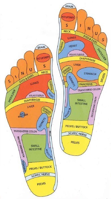
    A reflexology map of the soles of the feet.

    foot-reflexology.jpg

    Wonderful.


  • Closed Accounts Posts: 5,995 Ipso
    ✭✭✭


    So where do you rub to get rid of the covid?


  • Registered Users, Registered Users 2 Posts: 14,964 retalivity
    ✭✭✭✭


    Ipso wrote: »
    So where do you rub to get rid of the covid?

    If i show you, you have to promise not to call the police


  • Registered Users, Registered Users 2 Posts: 10,116 Junkyard Tom
    ✭✭✭✭


    retalivity wrote: »
    If i show you, you have to promise not to call the police


  • Moderators, Society & Culture Moderators Posts: 15,919 smacl
    Mod ✭✭✭✭


    3D geological map of Ireland

    0?e=1591833600&v=beta&t=XeD_5GrOgM99MgDSAXaTSLURCsi_7urXecHlh1eFC7c


  • Advertisement
  • Registered Users, Registered Users 2 Posts: 11,205 greenspurs
    ✭✭✭✭


    What year is that 3d map of Ireland from ?
    Beautiful map!
    247469249_2017413731748359_7675802031635703098_n.jpg

    "Bright lights and Thunder .................... " #NoPopcorn


Welcome!

It looks like you're new here. Sign in or register to get started.
Advertisement