Advertisement
If you have a new account but are having problems posting or verifying your account, please email us on hello@boards.ie for help. Thanks :)
Hello all! Please ensure that you are posting a new thread or question in the appropriate forum. The Feedback forum is overwhelmed with questions that are having to be moved elsewhere. If you need help to verify your account contact hello@boards.ie
Hi all,
Vanilla are planning an update to the site on April 24th (next Wednesday). It is a major PHP8 update which is expected to boost performance across the site. The site will be down from 7pm and it is expected to take about an hour to complete. We appreciate your patience during the update.
Thanks all.

8th Annual Boards White Christmas thread (2017)

  • 01-11-2017 5:40pm
    #1
    Registered Users Posts: 3,133 ✭✭✭


    Its that day again, 1 November, when, with Halloween over us, thoughts turn to the next big event on the horizon (besides Ireland v Denmark) - yup Christmas is coming....

    As usual this thread is solely concerned with the weather over the Christmas period, primarily 24 & 25 December and, in particular, is concerned with whether it might snow on Christmas day itself.

    The last white Christmas (as in lying snow) for most of us was 2010 of course. However I don't think there was any Christmas day snowfall that year. The last actual white Christmas in my part of the country (1cm of snow lying I think?) was 2004.

    The CFS is probably the best source at this stage for making any sort of guess as to what weather we might have on the big day. At present it shows the following:-

    17122500_0100.gif

    17122500_0100.gif

    17122500_0100.gif

    Subject to correction that's a fairly big bland area of low pressure with temps of 8c or so and uppers of about -2c (typically you need -8c uppers for snow). So at the moment its a no to snow on the big day - though there is just about time for an upgrade...

    Lest you think this is ridiculously premature (and I appreciate it probably is), a few websites have had a White Christmas page on the go for a while now. theweatheroutlook.co.uk are always the most enthusiastic and run a forecast from 1 September each year. They have updated theirs today actually and are saying:-

    "...It's expected to be too mild for snow in the south.
    Snow is expected in Wales 
    Snow is expected in the Midlands 
    It's expected to be too mild for snow in the north.
    Cold conditions in Scotland are expected. Marginal for rain or snow.
    It's expected to be too mild for snow in Northern Ireland
    It's expected to be too mild for snow in the Republic of Ireland
    Cold but dry conditions are expected in the Netherlands

    Forecast issued 01/11/2017 15:10:59"
    .

    Which is actually all very promising really.

    I will update this every 5 days or so in November but will update it more frequently in December, especially if things are looking in any way promising. Usually by 10 December or so we know that our goose (or turkey?) is cooked however.

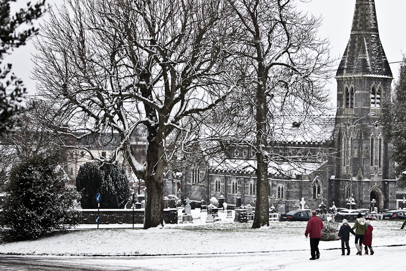
    Until then, here's a seasonal pic to whet the appetite. Last year I posted photos from around the country so will continue to do that this year. I don't think Waterford got a look in last year so here's a photo (which google images swears is Waterford) to address that:-

    4262725836_044f5078a5_o.jpg


Comments

  • Registered Users Posts: 3,133 ✭✭✭Rebelbrowser


    Actually I have inadvertently put the wrong year in the thread title. Can a mod fix this please as I think I can't do it once posted?

    Thanks


  • Closed Accounts Posts: 6,466 ✭✭✭Lumi


    Actually I have inadvertently put the wrong year in the thread title. Can a mod fix this please as I think I can't do it once posted?

    Thanks

    Done!


  • Moderators, Business & Finance Moderators, Recreation & Hobbies Moderators Posts: 24,714 Mod ✭✭✭✭Loughc


    All aboard the snow train here! Here's hoping for a white one.


  • Closed Accounts Posts: 444 ✭✭Minister


    Until then, here's a seasonal pic to whet the appetite. Last year I posted photos from around the country so will continue to do that this year. I don't think Waterford got a look in last year so here's a photo (which google images swears is Waterford) to address that:-

    4262725836_044f5078a5_o.jpg

    Ferrybank Catholic Church, Waterford


  • Registered Users Posts: 3,133 ✭✭✭Rebelbrowser


    Just a quick post to keep the thread ticking over.

    At the moment the CFS suggests high pressure will dominate the last two weeks of the year which suggests high single figures by day with night frosts by way of inversion cold. Uppers of -1 or -2 so the entire set up, whilst quite pleasant and reasonably seasonal, entirely not conducive to white gold falling.... In fact the big day itself is forecast a bit warmer as the atlantic begins to push in on the HP.

    CFS for the big day below fyi..

    17122512_1600.gif

    17122512_1600.gif

    General look of late December below...

    17122000_1600.gif

    Netweather's most recent take is as follows:-

    "Once again this week, the map above for the 25th December is another mild one, meaning a green Christmas for the whole UK. It's just for illustration though, and just shows one particular possible scenario - we're just looking for trends right now. On that front, it's actually slightly more promising on this update, as recent days have seen one or two colder updates coming through."

    Anyway, with 37 days to go, it could yet change!

    I will leave you with a seasonal pic from Cork City this time...

    CorkCityInTheSnow_large.jpg?width=648&s=ie-352717


  • Advertisement
  • Moderators, Business & Finance Moderators, Recreation & Hobbies Moderators Posts: 24,714 Mod ✭✭✭✭Loughc


    Netweather's most recent take is as follows:-

    "Once again this week, the map above for the 25th December is another mild one, meaning a green Christmas for the whole UK. It's just for illustration though, and just shows one particular possible scenario - we're just looking for trends right now. On that front, it's actually slightly more promising on this update, as recent days have seen one or two colder updates coming through."

    Anyway, with 37 days to go, it could yet change!

    I don't expect a White Christmas anymore and yet somehow that post still disappointed me. :(

    Not looking good.


  • Registered Users Posts: 3,133 ✭✭✭Rebelbrowser


    Just to update this.

    If the CFS model is to be believed, once this blocked regimes ends ca. 10 December, low pressure breaks through somewhat but gets trapped between areas of HP to its east and west. This has the effect of having south westerlies stationery over us with resultant average to relatively mild temperatures and incessant rain. Yuck.

    Of course as other threads show there is serious debate as to what weather we can expect in a weeks time, let alone 19 days after that, so still absolutely nothing set in stone.

    No point in posting the NW and TWO Christmas Forecast updates as both are several days old. The current CFS charts for the big day are below. I have also pasted below a seasonal pic from our nation's capital just to keep the spirits up for those of us hoping for a white one...

    17122500_2900.gif

    17122500_2900.gif

    dublin_winter.jpg?w=900&h=600


  • Moderators, Business & Finance Moderators, Recreation & Hobbies Moderators Posts: 24,714 Mod ✭✭✭✭Loughc


    Thanks for the updates! :)

    It's not looking good is it! :(

    SByrnes forecast is usually spot on so that really rules out any chance for us this year.


  • Registered Users Posts: 3,133 ✭✭✭Rebelbrowser


    Just a quick update and to my mind things are looking a bit more interesting.....

    The CFS still shows a largely atlantic influenced regime by Christmas day albeit its not especially mild. See below.

    17122512_0400.gif

    17122512_0400.gif

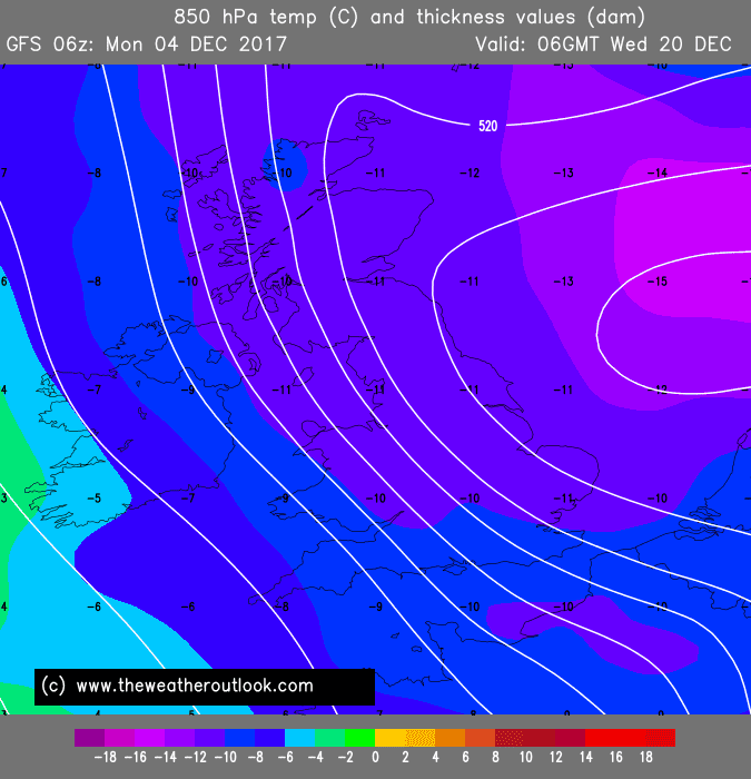
    The CFS is however a long term model and thus less accurate than the others. The main models, the GFS, the ECM, the GEM et al. are beginning now to show forecasts deeper into December. The GFS goes furthest out - to 20 December at this stage. In 5 days time it will have a Christmas day prediction (if you follow me).

    However on its 6z run just now it is showing cold weather spreading across NW Europe from the East by 20 December. Now this gets predicted about 5 times a winter and actually happens every 5 years or so - so don't get too excited. Also the GFS is not the best of the models - and none are really accurate at all until the weather is within 7 days or less. All those caveats aside, the below chart hints, just hints, at some real cold weather arriving in the days leading up to the big day.

    06_384_ukthickness850.png.f83495def87ce366e0e334f7e337094f.png

    Will keep you posted. Hopefully some of us we will see some falling white stuff this weekend anyway.

    I will leave til then with a seasonal picture from Kilkenny city...

    kilkenny-river-court.jpg


  • Registered Users Posts: 3,794 ✭✭✭Jude13


    Keeping an eye on this thread for packing purposes before my flight back to ireland. lessons from 2010


  • Advertisement
  • Registered Users Posts: 3,133 ✭✭✭Rebelbrowser


    A quick one. Latest guidance from CFS suggests wet and cold - yuck! Getting colder though than previous guidance. That's the general theme, the rest of the month looks cool with constant cold incursions from the north west. By Saturday we will have the GFS modelling for x-mas day so it gets more interesting now. You definitely couldn't rule out a white one just yet. Some quick snapshots from the models below...

    17122512_0700.gif

    17122512_0700.gif

    gfs-0-384.png?0?0

    And a seasonal pic from Limerick to finish (hopefully we will have up to date ones to add from some parts of the country by the weekend!)...

    7e555f2b1a96278e0a60253b10c1c568.jpg--a_heavy_blanket_of_snow_fell_on_limerick_this_wednesday__met_eireann_and_limerick_council_have_issued_a_red_weather_alert_for_wednesday_night__with_high_winds_expected__picture__adrian_butler.jpg


  • Registered Users Posts: 14,319 ✭✭✭✭M.T. Cranium


    GFS output has now reached 24 Dec, here's a summary of what it shows:

    after a cold period next week, milder intervals are expected around 20th, so that's the set-up, any snow that accumulates by 17th likely to melt around 20th and 21st when it could be close to 10-12 C (on this model guidance).

    So after that, a period of anticyclonic near calm or light southeast flow, relatively mild on 23rd and into 24th, would expect mostly cloudy with a few breaks, highs 6-9 C and slight frosts possible if breaks in overcast.

    The model does not go past that but trends indicate a slowly developing colder easterly flow, nothing really strong, but colder air would be seeping west across Britain into Ireland by 25th and more so on 26th with this set-up. So would expect more widespread frosts and lower daytime highs, slight chance of flurries hitting parts of southeast coastal areas (likely inland above 100m).

    Of course, a 16-day model depiction can change dramatically so take this as nothing more than the first glimpse of what one model is going to be showing. Will update these outlooks each time I feel there is a significant change in the GFS (and then later other models) output.


  • Registered Users Posts: 3,133 ✭✭✭Rebelbrowser


    Just to update this. GFS now modelling past 25 December so we can say so long and thanks to the CFS long range model (which wouldn't be designed for shorter term accuracy - albeit how accurate the GFS is at 14 days is another day's work).

    Current suggestions are for the current colder regime to end about a week before the big day with relatively milder Atlantic dominated weather in the run in to 25 December. This would not be conducive to a white Christmas so chances are slipping a little. However at 14 days away a lot can change. In fact one Christmas forecast below is still quite optimistic about colder weather reasserting before the big day. It will be Friday before we get the first indications from the best model, the ECM, which goes out to 10 days ahead.

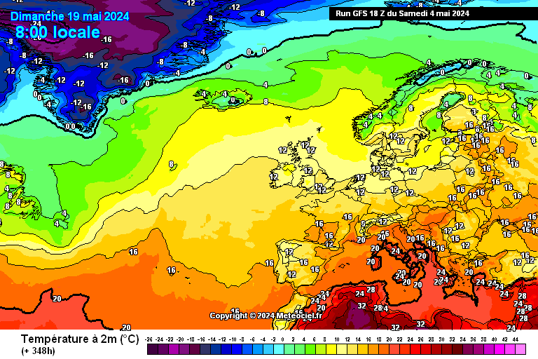
    Looking first at the GFS, it is going for a rainy day with temps of ca. 8c. See:-

    gfs-0-348.png?6?6

    gfs-2-348.png?6?6

    gfs-9-348.png?6

    Two different UK sites that do Xmas forecasts have released updates since yesterday and for the record they are as follows. Netweather goes for:-

    "...As we're still some way off, we're using a map from the GFS Ensembles, which shows us a range of options for Christmas day rather than a single definitive forecast........colder options are in the minority, but there are a few which point to the chance of some snow, especially across the northern half of the UK and Ireland. The overall picture matches up well with the current month ahead forecast, with some less settled, milder weather expected during the run-up to Christmas, with the potential for a transition to something colder again during the Xmas period.

    So, it's looking likely to be all about two sets of timing. If we're still in the unsettled phase, with low pressures moving through it'll be a case of whether we're affected by a milder or colder sector on the day. Or, maybe we'll be starting that process of colder weather starting to take hold again, although as it stands this is less likely...".


    The Weather Outlook go for:-

    "...Christmas Day is now within range of the 16 day GFS / GEFS computer model. Updates are every 6 hours and until the big day is less than a week away large swings in the forecast remain very possible. At the present time there are signs of it becoming less cold after mid-month. Milder conditions may not last for long and the ensembles are tentatively suggesting that temperatures could be on the way down by December 25th...."

    So still no reason just yet to write off a white one, especially as so many of you are surrounded by snow even as I write this (*sobs quietly to himself*).

    In those circumstances no need to put up a snowy picture, just look at most threads on here!. Lastly though what I might link to is a really good page on the UK Met Office site all about the history of White Christmases.

    See https://www.metoffice.gov.uk/learning/snow/white-christmas

    Happy reading!


  • Registered Users Posts: 15,775 ✭✭✭✭Slattsy


    I don't really mind if its not a white Christmas, but I do want a cold and dry one at the very least!!


  • Registered Users Posts: 3,133 ✭✭✭Rebelbrowser


    Getting interesting !


  • Registered Users Posts: 6,871 ✭✭✭pauldry


    Getting interesting !

    Nice Chart.

    Wish it could snow but be mild.

    I hate the cold but I love the snow


  • Registered Users Posts: 3,133 ✭✭✭Rebelbrowser


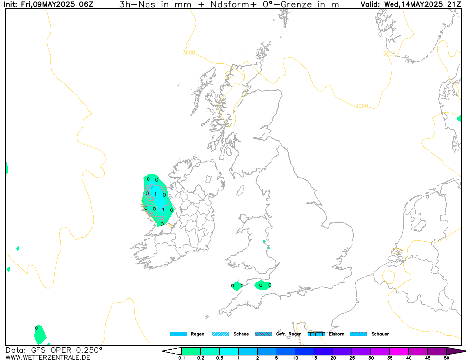
    OK, so it won't be a cold run in to Christmas. Also, there will not be any deep cold around Christmas - indeed there may be storms from 26th Dec onwards. BUT you can't rule out a white Christmas by any means. In fact the GFS has been suggesting a white Christmas for some in its last few runs. See the latest precipitation chart from the 6z run today below by way of example. White hatching = snow.

    162-574UK.GIF?18-6

    OK, some health warnings. Firstly GFS precipitation charts often show snow when none happens. I think in fairness white hatching just means some snow flakes (even if its mixed with mostly rain). Moreover this chart shows more rain than white hatching anyway. Also the white hatching is gone in the next frame. Moreover, at 7 days away, this is still not set in stone and could yet be dropped in the next model run - however that cuts both ways. Upgrades are possible too.

    For now its just nice to see a chart showing snow potential within a week of the big day. Moreover it looks likely at this stage that Christmas day itself will be cold and that's nice in and of itself.

    Anyway, in conclusion, you'd never know.....:)


  • Registered Users Posts: 3,133 ✭✭✭Rebelbrowser


    Just to add, a white Christmas is a bit of a nebulous concept. If the extract from Wikipedia below is correct its a lot easier to get in the UK than here where the definition seems very narrow (if this is correct) but equally doesn't even seem to be based on snow falling on the day itself.....

    From Wikipedia...

    "White Christmases in the United Kingdom[edit]


    In the United Kingdom, white Christmases were more common from the 1550s to the 1850s, during the Little Ice Age; the last frost fair on the River Thames, however, was in the winter of 1813–14.[13] The shift from the Julian to the Gregorian calendar in 1752 also slightly reduced the chance of a white Christmas, effectively moving Christmas earlier in the winter.[14] An "official" white Christmas is defined by the Met Office as "one snowflake to be observed falling in the 24 hours of 25 December somewhere in the UK",[14] but formerly the snow had to be observed at the Met Office building in London.[14] By the newer measure, over half of all years have white Christmases, with snow being observed 38 times in the 54 years to 2015.[14] A more "traditional" idea of snow-covered ground is less common, however, with only 4 occasions in the 51 years to 2015 reporting snow on the ground at 9am at more than 40% of weather stations.[14]

    Although most places in the UK do tend to see some snow in the winter, it generally falls in January and February. However white Christmases do occur, on average every 6 years.[13]

    Christmas 2009 was a white Christmas in some parts of Britain,[15] with thick lying snow which easterly winds had brought over the previous week. Travel over much of Britain was badly affected by ice and snow on roads, and was made more slippery by partial daytime thaw followed by overnight refreezing. It was the first white Christmas anywhere in the United Kingdom since 2004.[16]

    White Christmases in Ireland[edit]

    In Ireland, the prospect of early winter snow is always remote due to the country's mild and wet climate (snowfall is most common in January and February). Bookmakers offer odds every year for a white Christmas, which is officially lying snow being recorded at 09:00 local time on Christmas Day, and recorded at either Dublin Airport or Cork Airport (bets are offered for each airport). Since 1961, countrywide, snow has fallen on 17 Christmas Days (1961, 1962, 1964, 1966, 1970, 1980, 1984, 1990, 1993, 1995, 1998, 1999, 2000, 2001, 2004, 2009 and 2010), with nine of these having snow lying on the ground at 09:00 (1964, 1970, 1980, 1993, 1995, 1999, 2004, 2009 and 2010). The maximum amount of lying snow ever recorded on Christmas Day was 27 cm (11 in) at Casement Aerodrome in 2010.

    At Dublin Airport, there have been 12 Christmas Days with snowfall since 1941 (1950, 1956, 1962, 1964, 1970, 1984, 1990, 1993, 1995, 1999, 2000 and 2004). The statistical likelihood of snow falling on Christmas Day at Dublin Airport is approximately once every 5.9 years. However, the only Christmas Day at the airport ever to have lying snow at 09:00 was 2010 (although no snow actually fell that day), with 20 cm (7.9 in) recorded.[17]
    ".....


  • Registered Users Posts: 4,283 ✭✭✭arctictree


    Still a remote chance of some falling snow for parts of the North West on XMas day going by the latest GFS. A lot of mild weather around but per chance a slight colder interlude on the day itself:

    GFSOPUK06_135_53.png


  • Registered Users Posts: 3,133 ✭✭✭Rebelbrowser


    Yeah, the models seemed to be going in the direction of a warmer Christmas period until this morning but now its looking cool really from Christmas Eve night until the new year. GFS and ECM disagree on the big day itself, with ECM milder. GFS is back where it was a few days ago which is encouraging as the accuracy gets better the nearer you get obviously. With the below charts (mirroring really artictree's above) for later on Christmas day you can't rule out a white Christmas for some just yet.....:):) That of itself is an achievement 5 days out!

    132-574UK.GIF?20-6

    132-7UK.GIF?20-6

    132-21UK.GIF?20-6

    Its very much odds against but perhaps a couple of us might have a Christmas night like this yet....images?q=tbn:ANd9GcT2CrYsAKqxAhfmHgjQkWDjjLQjeSd2K8Z6xDCx_UshBHnxA5H2gA


  • Advertisement
  • Registered Users Posts: 3,133 ✭✭✭Rebelbrowser


    A Christmas night fall for some is still not out of the question.....


  • Registered Users Posts: 3,133 ✭✭✭Rebelbrowser


    Still cant rule this out for some before midnight on Christmas day..... In fact its likely the GFS is already the model that got temps on the day right because ecm is now agreeing with the gfs colder outlook. maybe it will get the precipitation correct too! See attached....


  • Moderators, Science, Health & Environment Moderators Posts: 11,803 Mod ✭✭✭✭Meteorite58


    The 18z gfs suggests there could still be late Christmas night snow ever before this next "event".

    Colder uppers move in all right but I wonder are the lower temperatures not cold enough ?

    tempresult_eed1.gif


    tempresult_fpz6.gif

    nmmuk-0-52-0_bcs5.png

    nmmuk-37-52-0_xxm4.png


  • Registered Users Posts: 3,133 ✭✭✭Rebelbrowser


    I see reports in another thread of wet snow in north Cork. Small chance yet Cork airport might record a technical white Christmas.....


  • Moderators, Entertainment Moderators, Science, Health & Environment Moderators Posts: 14,341 Mod ✭✭✭✭marno21


    First white one in a while! Merry Christmas weather forum.. (north Cork 195m ASL)


    437068.jpg


  • Registered Users Posts: 5,105 ✭✭✭John mac


    just as long as it stays away from cork airport till after midnight ... will do me .. ;)
    are you up Mullaghanish ?


  • Registered Users Posts: 14,319 ✭✭✭✭M.T. Cranium


    Is anyone able to confirm or refute snow at Knock (or any other reporting station) during the last few hours of the 25th for our forecast contest? I had a look in but there were no reports just the numbers which were inconclusive.

    I guess I could check the metars at some point.


  • Registered Users Posts: 8,219 ✭✭✭Gaoth Laidir


    Is anyone able to confirm or refute snow at Knock (or any other reporting station) during the last few hours of the 25th for our forecast contest? I had a look in but there were no reports just the numbers which were inconclusive.

    I guess I could check the metars at some point.

    There were no metars or manned observations at Knock yesterday, just the automated hourly synop reports, which don't report weather type (just like Claremorris down the road). There were also no metars from Cork Airport, but there were hourly manned synops. Only rain was reported.

    Elsewhere only rain showed up in the synops.


Advertisement