Advertisement
Help Keep Boards Alive. Support us by going ad free today. See here: https://subscriptions.boards.ie/.
https://www.boards.ie/group/1878-subscribers-forum

Private Group for paid up members of Boards.ie. Join the club.
Hi all, please see this major site announcement: https://www.boards.ie/discussion/2058427594/boards-ie-2026

Rescue 116 Crash at Blackrock, Co Mayo(Mod note in post 1)

1105106108110111136

Comments

  • Registered Users, Registered Users 2 Posts: 8,261 ✭✭✭Gaoth Laidir


    TomOnBoard wrote: »
    I'm thinking of the area, under water but close to the island and inaccessible to divers and Holland I, that I think GaothLaidir is thinking as well, rather than areas well outside the island where netting would take place.

    If, however someone could say that such seats are relatively light-weight and capable of being carried for distances by the current, then I might think very differently as other factors as to buoyancy etc would come into play.

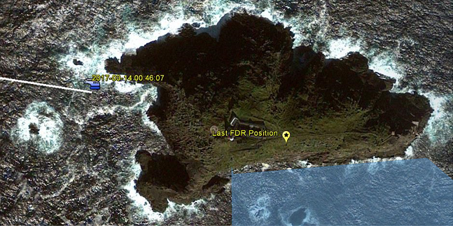
    Yes, this area I've shaded in to the south of the island, between the impact point and final wreckage.

    414724.png


  • Registered Users, Registered Users 2 Posts: 1,897 ✭✭✭Means Of Escape


    TomOnBoard wrote: »
    Authority gradients are found in civilian life every day. The Theatre Surgeon who is known to throw the instruments on the floor in a strop prevents junior assistants from saying "watch that bleeder".

    Proper procedures, good allocation of roles, regular training, team building and bonding all play a role in limiting the reality of authority gradients, and ensuring that individual members are heard and their commands (as distinct from their advices) acted upon without question when required. As in all things human however, individual personalities and their inter- personal interactions come into play also.

    Catpain Jacob van Zanten is a classic case of a failure on all of the above


  • Registered Users, Registered Users 2 Posts: 215 ✭✭Coil Kilcrea


    Yes, this area I've shaded in to the south of the island, between the impact point and final wreckage.

    414724.png

    Treacherous terrain to fish in never mind trying to conduct an underwater search.


  • Registered Users, Registered Users 2 Posts: 5,114 ✭✭✭TomOnBoard


    Treacherous terrain to fish in never mind trying to conduct an underwater search.

    Undoubtedly, and that is why consideration of alternatives to the use of divers is needed.


  • Registered Users, Registered Users 2 Posts: 8,261 ✭✭✭Gaoth Laidir


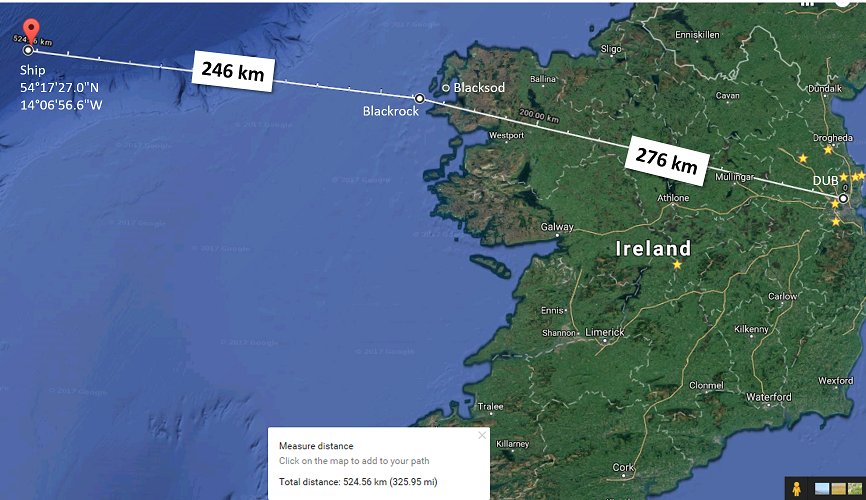
    I've made this map showing all locations relative to eachother, including the ship. I didn't realise it but the ship was 30 km nearer to Blackrock than Dublin was.

    On the question of why they started the approach to Blacksod from so far out, it could be that they were trying to fly as far west as possible to make radio contact with R118. They were at BKSDA at 4000 ft when they still could not make radio contact and at that point (00:34) notified Shannon of their intent to land. From there they started their descent.

    From their highest point of 4000 ft at BLKSDA their line of sight distance was only around 120 km, so there was no way they would have picked up R118, which was most likely down near the vessel 250 km away, having left Blacksod 1.25 hrs earlier (at 23:18). They would have needed to fly another 30 minutes or so until they picked up R118, assuming it was low level over the ship.

    414732.png

    414734.PNG


  • Advertisement
  • Registered Users, Registered Users 2 Posts: 888 ✭✭✭cosanostra


    I've made this map showing all locations relative to eachother, including the ship. I didn't realise it but the ship was 30 km nearer to Blackrock than Dublin was.

    On the question of why they started the approach to Blacksod from so far out, it could be that they were trying to fly as far west as possible to make radio contact with R118. They were at BKSDA at 4000 ft when they still could not make radio contact and at that point (00:34) notified Shannon of their intent to land. From there they started their descent.

    From their highest point of 4000 ft at BLKSDA their line of sight distance was only around 120 km, so there was no way they would have picked up R118, which was most likely down near the vessel 250 km away, having left Blacksod 1.25 hrs earlier (at 23:18). They would have needed to fly another 30 minutes or so until they picked up R118, assuming it was low level over the ship.

    414732.png

    414734.PNG

    Surely they would have mentioned this in the report wheras the report seems to imply there was no abnormalities in their approach but have asked the company to review their flight plans


  • Registered Users, Registered Users 2 Posts: 8,261 ✭✭✭Gaoth Laidir


    cosanostra wrote: »
    Surely they would have mentioned this in the report wheras the report seems to imply there was no abnormalities in their approach but have asked the company to review their flight plans

    Yes, but we do we know if they MUST use the full APBSS into Blacksod, starting at BLKMO? Remember, this route seems to be for flying from one lighthouse to another. I wonder if R118 did too or if they came down closer. Hopefully we'll know in the final report.


  • Registered Users, Registered Users 2 Posts: 5,114 ✭✭✭TomOnBoard


    I've made this map showing all locations relative to eachother, including the ship. I didn't realise it but the ship was 30 km nearer to Blackrock than Dublin was.

    On the question of why they started the approach to Blacksod from so far out, it could be that they were trying to fly as far west as possible to make radio contact with R118. They were at BKSDA at 4000 ft when they still could not make radio contact and at that point (00:34) notified Shannon of their intent to land. From there they started their descent.


    Very helpful image. Thanks.

    I think the earlier radio comms with Shannon highlights that very point. SNN asked if they were going all the way out in their efforts to make contact and they said something like they hadnt decided. Clearly there was some indecision as to what the next steps were going to be as they said they were going to put down and figure it out.

    You mention a line of sight distance at 120 km. Line of sight to what?


  • Registered Users, Registered Users 2 Posts: 2,985 ✭✭✭Stovepipe


    just to clarify, all the images that the crewman at the console on the left hand side of the cabin can see, can be transferred to the copilot or pilots' EFIS as required. It may yet be possible to establish who was watching what device, possibly from switch selection, if such items are found. So, the copilot can have FLIR or radar or normal EFIS on demand.


  • Registered Users, Registered Users 2 Posts: 8,261 ✭✭✭Gaoth Laidir


    TomOnBoard wrote: »
    Very helpful image. Thanks.

    I think the earlier radio comms with Shannon highlights that very point. SNN asked if they were going all the way out in their efforts to make contact and they said something like they hadnt decided. Clearly there was some indecision as to what the next steps were going to be as they said they were going to put down and figure it out.

    You mention a line of sight distance at 120 km. Line of sight to what?

    A radio line of sight.


  • Advertisement
  • Registered Users, Registered Users 2 Posts: 5,114 ✭✭✭TomOnBoard


    Yes, this area I've shaded in to the south of the island, between the impact point and final wreckage.

    And here's a post of a Navionics plot Steve did a while back that informs your shaded area.

    http://www.boards.ie/vbulletin/showpost.php?p=103145259&postcount=2556


  • Registered Users, Registered Users 2 Posts: 5,114 ✭✭✭TomOnBoard


    A radio line of sight.

    Doh!


  • Registered Users, Registered Users 2 Posts: 8,261 ✭✭✭Gaoth Laidir


    Actually, the radio service horizon, dr, is a little longer, around 145 km, but still in the same ballpark.

    https://www.everythingrf.com/rf-calculators/line-of-sight-calculator

    radio_horizon_formula_image.PNG


  • Registered Users, Registered Users 2 Posts: 527 ✭✭✭de biz


    Informative comment from former SAR pilot David Courtney in the Irish Times:

    "warm-sector misty weather conditions degrade infra-red camera performance and no doubt this will feature in further analysis of the accident data."


  • Registered Users, Registered Users 2 Posts: 360 ✭✭Paddy De Plasterer


    now that report is out, it seems Blackrock was not listed in their technology, but I am wondering why they did not see the big rock with a working lighthouse on top of it.


  • Registered Users, Registered Users 2 Posts: 360 ✭✭Paddy De Plasterer


    It seems from a report in todays papers that they almost made it, hit roof of house on top of the rock beside the lighthouse.


  • Moderators, Motoring & Transport Moderators Posts: 10,194 Mod ✭✭✭✭Tenger


    now that report is out, it seems Blackrock was not listed in their technology, but I am wondering why they did not see the big rock with a working lighthouse on top of it.
    Answered multiple times in thread.
    Almost 1am, dark night, black rock, rain and mist, cloud base at 300ft, lighthouse designed to signal to ships, aircraft strobes refecting off clouds.


  • Registered Users, Registered Users 2 Posts: 963 ✭✭✭Bussywussy


    It seems from a report in todays papers that they almost made it, hit roof of house on top of the rock beside the lighthouse.

    Prime reason I haven't gone near any media relating to this,it did not hit the roof of the outhouse,report says something along lines of the damage to roof is consistent with falling debris


  • Registered Users, Registered Users 2 Posts: 5,114 ✭✭✭TomOnBoard


    It seems from a report in todays papers that they almost made it, hit roof of house on top of the rock beside the lighthouse.

    Almost made it? Yes. Hit the roof of that house? No. Bits of the post accident wreckage fell on the roof.


  • Registered Users, Registered Users 2 Posts: 360 ✭✭Paddy De Plasterer


    TomOnBoard wrote: »
    Almost made it? Yes. Hit the roof of that house? No. Bits of the post accident wreckage fell on the roof.

    I thought Gerry Byrne in todays IT said it hit roof of house,how did debris land there? But you agree it almost made it.


  • Advertisement
  • Registered Users, Registered Users 2 Posts: 360 ✭✭Paddy De Plasterer


    wonder will final report be more concise as regards placing blame ?


  • Registered Users, Registered Users 2 Posts: 9,550 ✭✭✭TheChizler


    It's not within the AAIU's remit to assign blame. The report deals with facts only.


  • Registered Users, Registered Users 2 Posts: 22,575 ✭✭✭✭Steve


    Hi Paddy, can you please actually read the report before commenting further as we are not allowing speculation on this.

    The AAIU does not assign blame, again this is clear if you care to read the actual report.

    http://www.aaiu.ie/sites/default/files/report-attachments/REPORT%202017-006%20PRELIMINARY.pdf


    Thanks. :)


  • Registered Users, Registered Users 2 Posts: 5,114 ✭✭✭TomOnBoard


    wonder will final report be more concise as regards placing blame ?

    None of this should be about blame! The investigation has no interest in blaming anyone. The inquest will have no interest in blaming anyone. People in the industry will have no interest in blaming anyone. Blame and shame mentalities have no place in any investigation into anything. Investigations as to fact should only be interested in establishing facts like what happened, where did it happen, when did it happen. It is for an assessment process after an investigation as to fact to focus more on the question of why and who. The question of who is where things go off the rails and to focus on that question too early in a process can lead to facts becoming more difficult to ascertain.


  • Registered Users, Registered Users 2 Posts: 1,924 ✭✭✭Reati


    wonder will final report be more concise as regards placing blame ?

    I quoted the AAIU several pages back and will repeat it here
    It is inappropriate that AAIU Reports should be used to assign fault or
    blame
    or determine liability, since neither the safety investigation nor the reporting process has been undertaken for that purpose.


  • Registered Users, Registered Users 2 Posts: 6,891 ✭✭✭allthedoyles


    Has anyone an update on the search for the missing crew ?


  • Registered Users, Registered Users 2 Posts: 7,490 ✭✭✭Damien360


    TomOnBoard wrote: »
    None of this should be about blame! The investigation has no interest in blaming anyone. The inquest will have no interest in blaming anyone. People in the industry will have no interest in blaming anyone. Blame and shame mentalities have no place in any investigation into anything. Investigations as to fact should only be interested in establishing facts like what happened, where did it happen, when did it happen. It is for an assessment process after an investigation as to fact to focus more on the question of why and who. The question of who is where things go off the rails and to focus on that question too early in a process can lead to facts becoming more difficult to ascertain.

    All well and good but the families of the dead crewmen will apportion blame and rightly so. It will be a civil case that apportions blame.

    Crew followed SOP to the letter with regard to flight plan and landing. All very professional based on report of conversations. It will come down to he question of whether the employer has a legal obligation to the crew safety when one of the safety systems (mapping of landing area) is not accurate. Who is ultimately responsible will be the key.


  • Registered Users, Registered Users 2 Posts: 22,575 ✭✭✭✭Steve


    Damien360 wrote: »
    Crew followed SOP to the letter with regard to flight plan and landing. All very professional based on report of conversations.
    That is speculation, it hasn't been determined what the SOPs were or indeed whether or not they were followed.
    It will come down to he question of whether the employer has a legal obligation to the crew safety when one of the safety systems (mapping of landing area) is not accurate. Who is ultimately responsible will be the key.
    Ant there will be court cases over it for sure. It won't be a trial of public opinion, it will be a trial of fact.


  • Registered Users, Registered Users 2 Posts: 7,490 ✭✭✭Damien360


    Steve wrote: »
    That is speculation, it hasn't been determined what the SOPs were or indeed whether or not they were followed.

    Going out to sea and approaching poorly visible landing zone at 200ft until visible sighting is part of SOP, is it not ? Using automated system for landing in this situation is again part of procedure? Am I mixing up discussion here and preliminary report ?


  • Advertisement
  • Registered Users, Registered Users 2 Posts: 22,575 ✭✭✭✭Steve


    Damien360 wrote: »
    Going out to sea and approaching poorly visible landing zone at 200ft until visible sighting is part of SOP, is it not ? Using automated system for landing in this situation is again part of procedure? Am I mixing up discussion here and preliminary report ?

    I don't know, and neither can you unless you have flown SAR for CHC. Their SOPs are not in the public domain.


This discussion has been closed.
Advertisement