Advertisement
If you have a new account but are having problems posting or verifying your account, please email us on hello@boards.ie for help. Thanks :)
Hello all! Please ensure that you are posting a new thread or question in the appropriate forum. The Feedback forum is overwhelmed with questions that are having to be moved elsewhere. If you need help to verify your account contact hello@boards.ie
Help Keep Boards Alive. Support us by going ad free today. See here: https://subscriptions.boards.ie/.
If we do not hit our goal we will be forced to close the site.

Current status: https://keepboardsalive.com/

Annual subs are best for most impact. If you are still undecided on going Ad Free - you can also donate using the Paypal Donate option. All contribution helps. Thank you.

Completing the M7

  • 12-09-2023 04:28PM
    #1
    Registered Users, Registered Users 2 Posts: 536 ✭✭✭


    As many of you will know the original plan for the M7 was for it to continue from Naas to junction 8 on the M50 along a route presumably in the centre strip between the canal and the railway line. This section would have had 6 junctions, with today's junction 9 being junction 7.

    This was flushed away down the toilet and the decision was made to widen the existing N7 to a six-lane DC with bypasses at round Rathcoole and Kill etc. The cherry on the top for the original M7 plan was the Newlands Cross flyover.

    This should not have happened. The M7 should have continued from Naas as a D3 motorway up to junction 8 near Park West on the M50. If I recall there is still land reservation on some parts of the original M7 route that have not been built over, and any structures that have been built are commercial buildings that can be demolished and relocated.

    Completing the M7 not only would be safer and decrease travel times to Naas and beyond on the M7, it would also open up major business opportunities on the existing Naas Road from the Red Cow to Naas. If we get rid of the GSJs and remove one of the lanes to narrow down to just a D2 DC on both sides the economic potential is enormous. Once detrunked to the R445 and with associated regulations removed, the entire road could become a development corridor with apartments, warehousing etc all built alongside and with access from the DC. High rise should be concentrated alongside this strip.


«1

Comments

  • Moderators, Science, Health & Environment Moderators Posts: 5,464 Mod ✭✭✭✭spacetweek


    Zero chance! Too easy to upgrade the N7 Naas-M50 to motorway and Clonburris and Milford Manor have been built on the M7 alignment.

    When the new Adamstown-Ronanstown road was built in the 2000s, it was clear that this was the replacement for the M7. All the remaining land there will be built on.

    Although you could still build Naas-Adamstown as M7, what would be the point? It would not connect with any other motorways and it's not a good idea to end a motorway on distributor roads. Even if another M50 was built around west Dublin and you connected new M7 with that, most traffic would still use N7 as it connects directly with the M50.

    Also, when new Clondalkin/Fonthill and Kishogue train stations were built in 2008, it became clear that all the land around them would be urbanised with housing. Which meant there'd be no M7 through there.


  • Registered Users, Registered Users 2 Posts: 73,788 ✭✭✭✭L1011


    The land reservation is gone; it isn't just light commercial on it.

    The decision to upgrade the N7 for the Ryder Cup ensured it was never going to happen and the posts every 18 months or so suggesting it should be dusted off all get the same response - this will never, ever happen.

    This plan is as dead as the tangent motorways in the city centre.


  • Registered Users, Registered Users 2 Posts: 4,592 ✭✭✭AugustusMinimus


    I don’t see why high rise along the current Naas Dual Carriageway would make any sense. High and mid rise should be concentrated in city centres, not in the suburbs.


  • Registered Users, Registered Users 2, Paid Member Posts: 2,801 ✭✭✭KrisW1001


    I know we've a housing crisis and all, but you'd have very few people who'd choose to live right next to the busiest road in the state.

    This kind of development was shown to be a bad idea as early as the 1960s. People prefer to live in places where they can walk easily. For cities, that means denser inner city neighbourhoods with lots of stuff in easy reach.


  • Registered Users, Registered Users 2 Posts: 536 ✭✭✭dublincc2


    The development of high-rise alongside an arterial route is very common in most of Europe.

    As for Clonburris and the other buildings that have been erected on the reservation, CPO is the only solution. The housing stock that is demolished can be replicated in high-rise alongside the downgraded Naas Road from the Red Cow to Maudlings. Concentrated high-density development in a straight line for several KM rather than destroying prime agricultural land around Kill and Johnstown etc which is what is happening now.


  • Advertisement
  • Registered Users, Registered Users 2 Posts: 78,786 ✭✭✭✭Victor


    Why not just keep the Naas Road, much as is* and have your development along the railway line, allowing people quick access to the city that way?

    * I would be tempted to close some junctions and keep local traffic on the parallel side roads.


  • Registered Users, Registered Users 2 Posts: 73,788 ✭✭✭✭L1011


    No, the only solution is not trying to resurrect decades dead plans that have been made entirely unnecessary by other upgrades.


  • Registered Users, Registered Users 2 Posts: 4,592 ✭✭✭AugustusMinimus


    Could someone show where the M7 was planned to run? I’ve taken a look in Google maps and I can’t see any undeveloped route between the N4 and N7 M50 junctions.


  • Registered Users, Registered Users 2 Posts: 78,786 ✭✭✭✭Victor


    M7.png

    That's the point of what people have been replying to the OP - there is no current viable route. Joining at a point between the canal and railway would have made sense, as the M50 is on a continuous embankment there.

    Something like the attached is what was proposed - but I've never seen anything firm. By the 1990s there were buildings obstructing the M50 end of the route, unless you wanted to use the New Nangor Road reservation, which would have been tight for a motorway.

    If you go here: https://webapps.geohive.ie/mapviewer/index.html and click on "Basemap Gallery" and "MapGenie Imagery (1995)", you can see how much less developed the area was in the 1990s.


  • Registered Users, Registered Users 2 Posts: 536 ✭✭✭dublincc2


    What were the 5 junctions to be built? 1 obviously was the M50 and 7 is todays junction 9 on the M7 but what about the others inbetween?


  • Advertisement
  • Registered Users, Registered Users 2 Posts: 536 ✭✭✭dublincc2


    I believe the intention was to run it entirely between the canal and the railway line as far as Naas. Pretty straight route.


  • Registered Users, Registered Users 2, Paid Member Posts: 2,801 ✭✭✭KrisW1001


    ... and it was to have gone deeper into Dublin. M50 is a latecomer to Dublin's motorway plans: the original vision had motorways ending at or inside the Circular Roads.

    @dublincc2 yes, other countries have this kind of development, but most of it was done in the 1950s and 1960s. That kind of planning doesn't happen anymore for a reason: traffic. The urban planners of the 1950s thought that traffic congestion, pollution and noise was caused by road bottlenecks, and thus could be effectively removed by widening the roads. We know better now...


  • Registered Users, Registered Users 2 Posts: 990 ✭✭✭Fred Cryton


    Yes, we're so wise now, we make it so difficult for people to drive into town that they drive to out of town shopping centres instead while the city centre rots.

    Sure aren't we geniuses.


  • Registered Users, Registered Users 2 Posts: 3,716 ✭✭✭hans aus dtschl


    You're right, we need more cars in the city centre.

    Moar cars!


  • Registered Users, Registered Users 2 Posts: 809 ✭✭✭Jayuu


    I think what we're doing is saying that potentially the city centre might be a more attractive place to go for people if it wasn't completely thronged with cars. And I say that as someone who really likes to drive. But even well before any of these changes I have always hated having to drive into the city centre in my car.

    I also don't see Grafton Street or Henry Street shutting down anytime soon even if is difficulr to get to them by car.


  • Moderators, Social & Fun Moderators, Paid Member Posts: 13,864 Mod ✭✭✭✭JupiterKid


    On the subject of the M7 and N7, here's an amazing aerial shot of Newlands Cross taken in the early 1930s.

    The Naas Road runs from middle left to lower right. The photo is looking south.

    It's changed a little since then! 😁

    52167609546_1c82b32e8c_b.jpg


  • Registered Users, Registered Users 2 Posts: 536 ✭✭✭dublincc2


    An update to this, I found an old article (1997) which shows part of the junction 8 route along with the new road alignment at Fonthill:

    IMG_0889.jpeg


  • Registered Users, Registered Users 2 Posts: 6,211 ✭✭✭Chris_5339762


    Its very very vague, but interesting that they show the alignment going inside of the M50.


  • Moderators, Science, Health & Environment Moderators Posts: 5,464 Mod ✭✭✭✭spacetweek


    Yes that's the most interesting part.

    Urgh, look at all those awful roundabouts on the M50!


  • Registered Users, Registered Users 2 Posts: 19,052 ✭✭✭✭murphaph


    Is the OP proposing scrapping all the N7 upgrades and then duplicating them in a new build alignment to do pretty much the exact same thing, except slightly further to the north and all so we can extend the US style strip out as far as Naas?


  • Advertisement
  • Registered Users, Registered Users 2 Posts: 536 ✭✭✭dublincc2


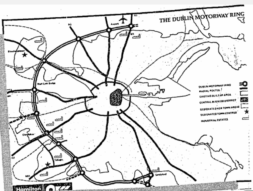
    Found this map of the M50 plans, it shows J8 going from just north of the railway at the Cloverhill Road bridge area and southwest through Milford Manor, which used to be a truck stop at one point.


    Still haven’t found any concrete info on where the missing 5 junctions between the M50 and Naas would’ve been.

    IMG_3004.jpeg


  • Registered Users, Registered Users 2 Posts: 536 ✭✭✭dublincc2


    Also it appears that unlike what L1011 suggested above regarding the improvements undertaken ahead of the Ryder Cup, it was actually good old fashioned FF developer rezoning that killed the M7 to J8 - the road would’ve passed through the planned ‘Marina Village’ development at Hazelhatch which doesn’t exist to this day and I’m not exactly where it would’ve been located.


  • Registered Users, Registered Users 2 Posts: 536 ✭✭✭dublincc2


    Would anyone know who I should contact to find detailed maps of this former route alignment?


  • Registered Users, Registered Users 2 Posts: 73,788 ✭✭✭✭L1011


  • Registered Users, Registered Users 2 Posts: 536 ✭✭✭dublincc2


    I thought you said you’d seen plans for them at one point?

    I know from the newspaper archives that plans were presented to councillors in the mid-90s but can’t find anything.


  • Registered Users, Registered Users 2 Posts: 73,788 ✭✭✭✭L1011


    "plans" being a line on a low scale map does not mean any detailed drawings ever existed; and I strongly suspect they didn't.

    But more importantly - no, I didn't say that.


  • Registered Users, Registered Users 2 Posts: 536 ✭✭✭dublincc2


    Just checked and you said on another thread the alignment was for 2x2 and the route went roughly along the railway line to Maudlings, so I assumed you had seen some form of the details to come up with that conclusion.


  • Registered Users, Registered Users 2 Posts: 73,788 ✭✭✭✭L1011


    Presumably another thread being something from 15-20 years ago?

    All I've ever seen is basic lines on maps of alignments. You would not need detailed drawings at that point.


  • Registered Users, Registered Users 2 Posts: 536 ✭✭✭dublincc2


    This is what I saw.

    I’ll just ask directly, what was the route/layout of this reservation from what you can recall? As specific as you can remember? Where would the junctions have been?


  • Advertisement
  • Registered Users, Registered Users 2 Posts: 73,788 ✭✭✭✭L1011


    So no claim that I saw any plans, then.

    The 2x2 is in reference to the person I am replying to having a fetish for American sized roads and wanting to ram a TWELVE lane M7 through, it does not refer to the 2+2 road standard which did not exist at the time.

    There is nothing public beyond rough lines on low scale maps which you have already seen on this thread. There likely is nothing more than that anywhere; as there was likely no actual design work done. Creepily digging through peoples old posts is not going to make plans exist!


Advertisement