Advertisement
If you have a new account but are having problems posting or verifying your account, please email us on hello@boards.ie for help. Thanks :)
Hello all! Please ensure that you are posting a new thread or question in the appropriate forum. The Feedback forum is overwhelmed with questions that are having to be moved elsewhere. If you need help to verify your account contact hello@boards.ie

Howth scenic route

Options
2»

Comments

  • Registered Users Posts: 3,107 ✭✭✭mr spuckler


    It looks like there are plenty of tracks up around the quarry to explore and should be much quieter up there too. I plan to take the MTB up there one of the days anyway.


  • Closed Accounts Posts: 2,281 ✭✭✭CrankyHaus


    It looks like there are plenty of tracks up around the quarry to explore and should be much quieter up there too. I plan to take the MTB up there one of the days anyway.


    Some of them are a good bit wider than the cliff walk too, making it less of an issue if you encounter pedestrians.


  • Registered Users Posts: 646 ✭✭✭Tony04


    I mtb alot around howth and really the cliffs are best to avoid as you can only ride from balscadden to baileys anyway and I would only ride that from September to april or at sunrise in the summer morning and at that I would only really ride uphill on the paths rather than downhill.

    Theres a good few quiter paths around the masts which are fine to ride on but howth is more suited to climbing than downhills as any downhill that's reasonable to go on, I.e no walkers, are pretty steep and technical.

    In terms of gravel biking your could ride rock a bit around the masts the upper cliff path and from the road at sheilmartin across the golf club to the quarry

    If anyone wants a map I might post one on here


  • Registered Users Posts: 3,107 ✭✭✭mr spuckler


    Tony04 wrote: »
    If anyone wants a map I might post one on here

    That would be great if you could, thanks :)


  • Registered Users Posts: 14,317 ✭✭✭✭Raam


    Try these maps...

    edit: hang on, file too big


  • Advertisement
  • Registered Users Posts: 14,317 ✭✭✭✭Raam


    Maps


  • Registered Users Posts: 646 ✭✭✭Tony04


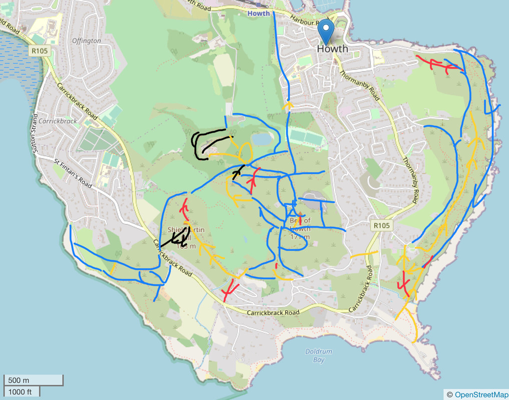
    Created this
    IMG-6467.jpg

    All the trails of howth as far to my knowledge excluded cliff path from red rock to bailey as it's not suited for bikes.
    Blue-suitable to gravel bikes
    Yellow- kind of technical mtb more suited.
    Red- really technical
    Black- extremely technical


  • Registered Users Posts: 646 ✭✭✭Tony04


    Tony04 wrote: »
    Created this
    IMG-6467.jpg

    All the trails of howth as far to my knowledge excluded cliff path from red rock to bailey as it's not suited for bikes.
    Blue-suitable to gravel bikes
    Yellow- kind of technical mtb more suited.
    Red- really technical
    Black- extremely technical

    Edit: sorry about the inaccuracies hopefully it gives you a gist of where the trails are
    Completely forgot about the tram line
    Also alot of trails had work done recently which involves adding kerbs in in some steep sections so be careful not to puncture on these if coming down these sections


  • Registered Users Posts: 9,133 ✭✭✭RobertFoster


    Raam wrote: »
    Maps
    I had such a good time in the Bog of Frogs I got lost and ended up at the Hippy Hole in Doldrum Bay.


  • Moderators, Category Moderators, Arts Moderators, Sports Moderators Posts: 48,482 CMod ✭✭✭✭magicbastarder


    at least you didn't end up with a worn hole.
    (is that a typo for worm hole?)


  • Advertisement
Advertisement