Advertisement
Help Keep Boards Alive. Support us by going ad free today. See here: https://subscriptions.boards.ie/.
If we do not hit our goal we will be forced to close the site.

Current status: https://keepboardsalive.com/

Annual subs are best for most impact. If you are still undecided on going Ad Free - you can also donate using the Paypal Donate option. All contribution helps. Thank you.
https://www.boards.ie/group/1878-subscribers-forum

Private Group for paid up members of Boards.ie. Join the club.

Interesting Maps

1367368370372373378

Comments

  • Registered Users, Registered Users 2 Posts: 1,480 ✭✭✭OneEightSeven
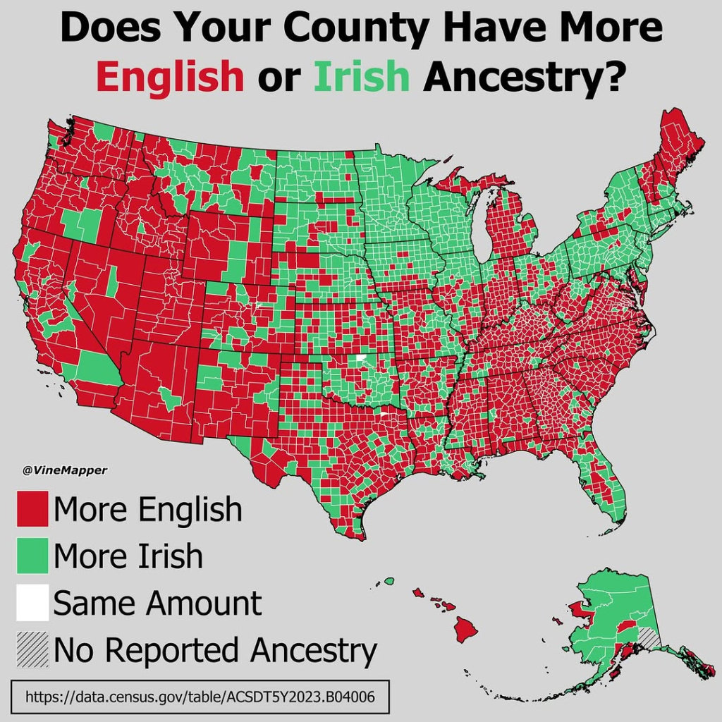
    MEGA - Make Éire Great Again


    555534148_1142756964633579_904945682234538585_n.jpg

    1.


  • Registered Users, Registered Users 2 Posts: 866 ✭✭✭minggatu


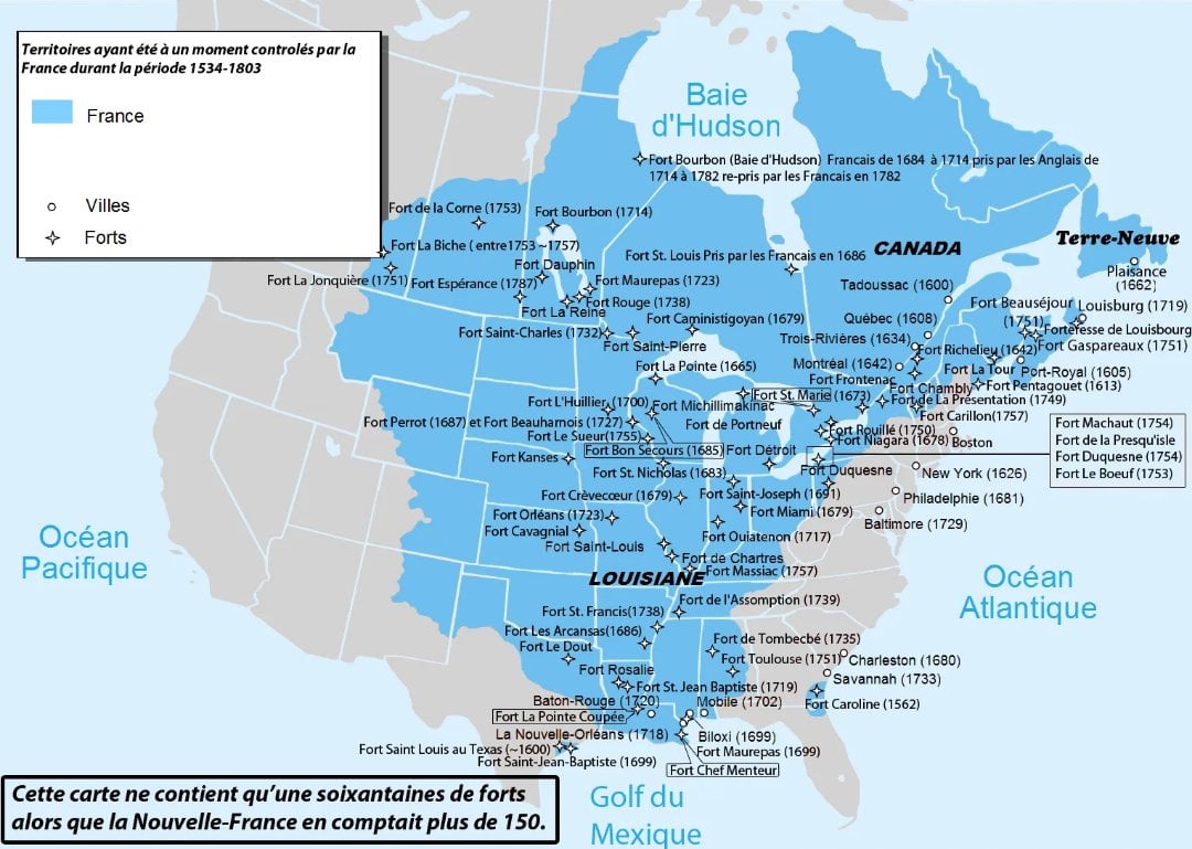
    Maximum Extent of French Territory in North America

    G12EWsZXoAAelCY.jpg

    https://x.com/BrilliantMaps/status/1971877743043256387


  • Registered Users, Registered Users 2 Posts: 32,428 ✭✭✭✭zell12


    ex-colony Madagascar is mostly surrounded by France

    image.png


  • Registered Users, Registered Users 2 Posts: 866 ✭✭✭minggatu


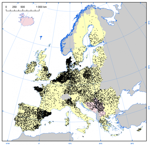
    Pig farm density in Europe

    G13ABFiWMAAob3B.png

    https://x.com/onlmaps/status/1971943342746620031


  • Registered Users, Registered Users 2 Posts: 866 ✭✭✭minggatu


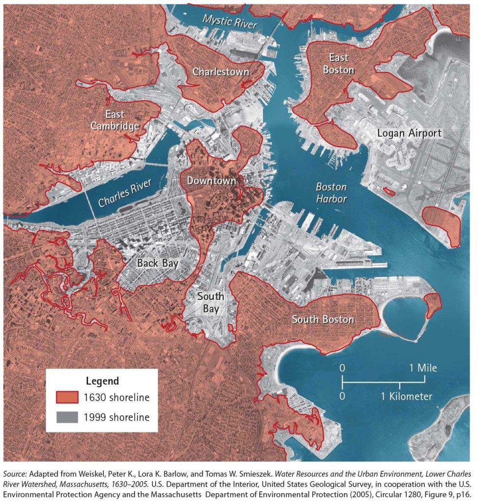
    Since 1630, land reclamation has made Boston over 10 times larger

    G133hXWb0AMoevb.jpg


  • Advertisement
  • Registered Users, Registered Users 2 Posts: 21,107 ✭✭✭✭gormdubhgorm


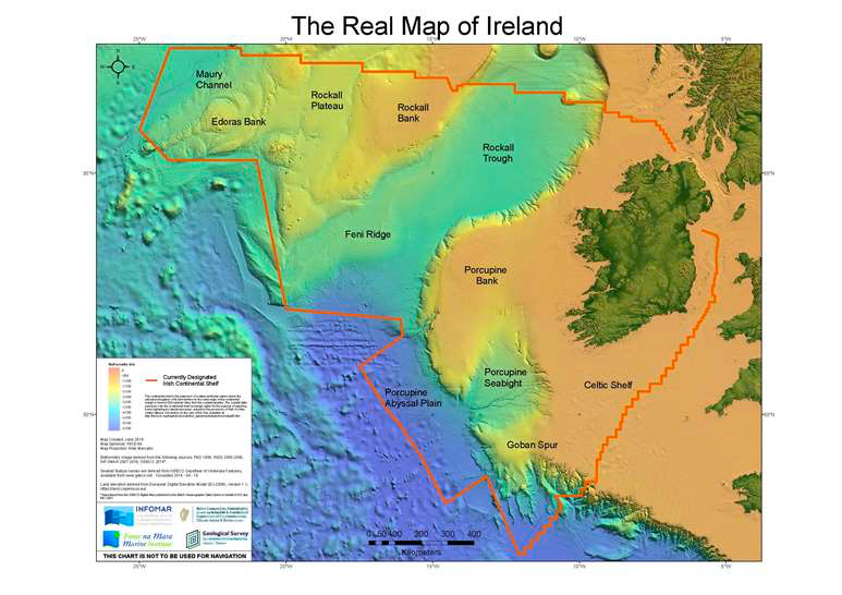
    Irelands “marine territory” not to be confused with “territorial waters”. It is 10 times Ireland’s land mass.

    IMG_2381.png

    Guff about stuff, and stuff about guff.


  • Registered Users, Registered Users 2 Posts: 866 ✭✭✭minggatu


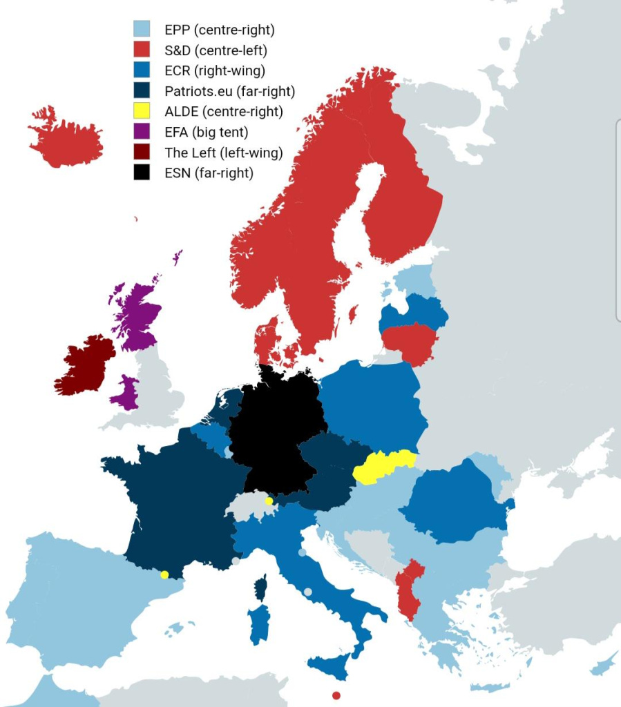
    What eu group does your country's leading party belong to? (Includes both full members and non-eu associates) kqbywzb2fwrf1.jpeg

    https://www.reddit.com/r/Maps/comments/1nsmzww/what_eu_group_does_your_countrys_leading_party/


  • Registered Users, Registered Users 2 Posts: 1,480 ✭✭✭OneEightSeven
    MEGA - Make Éire Great Again


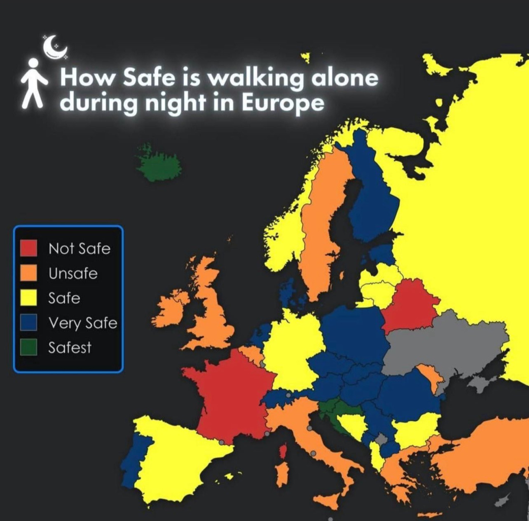
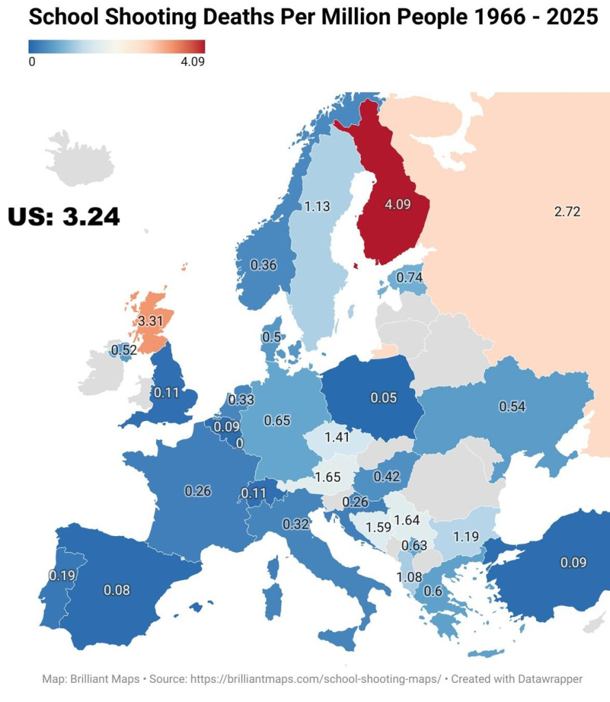
    Saw this on Twitter earlier. Not sure what metric they used for this.

    G18xhUUWIAALRld.jpg
    Post edited by OneEightSeven on


  • Registered Users, Registered Users 2 Posts: 41,115 ✭✭✭✭ohnonotgmail


    Doing it on a country by country basis is nonsense. The variations within each country will be massive.


  • Moderators, Category Moderators, Arts Moderators, Sports Moderators, Paid Member Posts: 54,216 CMod ✭✭✭✭magicbastarder


    infographics like that should be shot.

    whatever about an infographic not citing the source of the info, someone who creates an infographic which is opaque about what it actually means does not understand the 'info' in infographic.


  • Advertisement
  • Registered Users, Registered Users 2, Paid Member Posts: 28,143 ✭✭✭✭Peregrinus


    Amd safety from what, exactly? Assault? Traffic accidents? Does this basically correlate to the quality of the street lighting?


  • Registered Users, Registered Users 2 Posts: 866 ✭✭✭minggatu


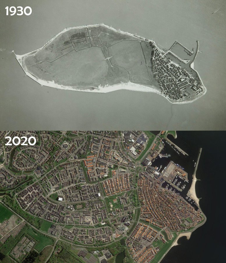
    Urk, the former island of the Netherlands

    G12aTpobwAAIMKx.jpg

    "

    Urk was once a small fishing island in the Zuiderzee, cut off from the Dutch mainland for centuries. That changed with the ambitious Zuiderzee Works: the sea was closed off by the Afsluitdijk in 1932, creating the IJsselmeer, and new land was reclaimed around Urk. By 1942, the Noordoostpolder connected Urk permanently to the mainland.Despite this, Urk has kept much of its old island character. It is still one of the Netherlands’ most important fishing communities and is known for its strong local traditions, dialect, and identity rooted in its island past."

    https://x.com/amazingmap/status/1971901877337182414


  • Moderators, Recreation & Hobbies Moderators, Science, Health & Environment Moderators, Technology & Internet Moderators Posts: 96,141 Mod ✭✭✭✭Capt'n Midnight


    image.png

    ..


  • Registered Users, Registered Users 2 Posts: 1,480 ✭✭✭OneEightSeven
    MEGA - Make Éire Great Again


    548023350_18422733151100882_4976686186557624999_n.jpg

    ''


  • Moderators, Politics Moderators, Paid Member Posts: 44,263 Mod ✭✭✭✭Seth Brundle


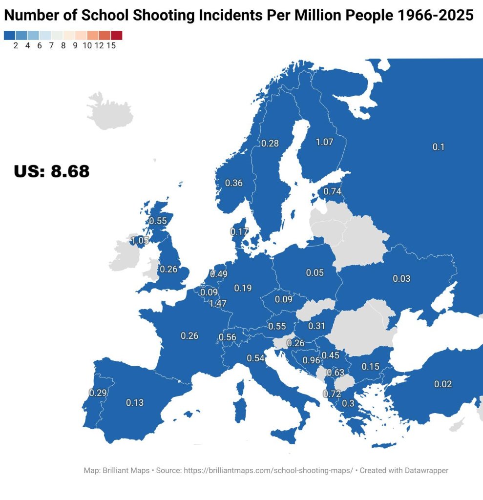
    Unsure why we, amongst others, are n/a. Plus n/a having the same colour as 7-8 doesn’t help the visual.

    Help Keep Boards Alive. Support us by going ad free today. See here: https://subscriptions.boards.ie/ .


  • Registered Users, Registered Users 2 Posts: 74,265 ✭✭✭✭L1011


    The figure for here is 0, though I'd suspect it might not be for some of the others.

    One pot for "no public figures or those figures are zero" then!


  • Registered Users, Registered Users 2, Paid Member Posts: 15,010 ✭✭✭✭josip


    I think Ireland's grey represent "no data" rather than zero because there have been shooting incidents.

    https://www.independent.ie/irish-news/pupils-and-teacher-wounded-in-school-shooting/26174755.html


  • Registered Users, Registered Users 2 Posts: 866 ✭✭✭minggatu


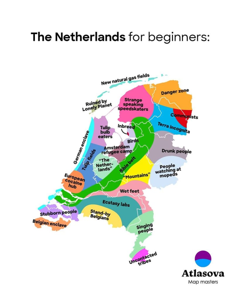
    Map Of The Netherlands For Beginners Based On Regional Stereotypes

    G2CumKmXsAASnEu.jpg


  • Moderators, Social & Fun Moderators, Paid Member Posts: 14,017 Mod ✭✭✭✭JupiterKid


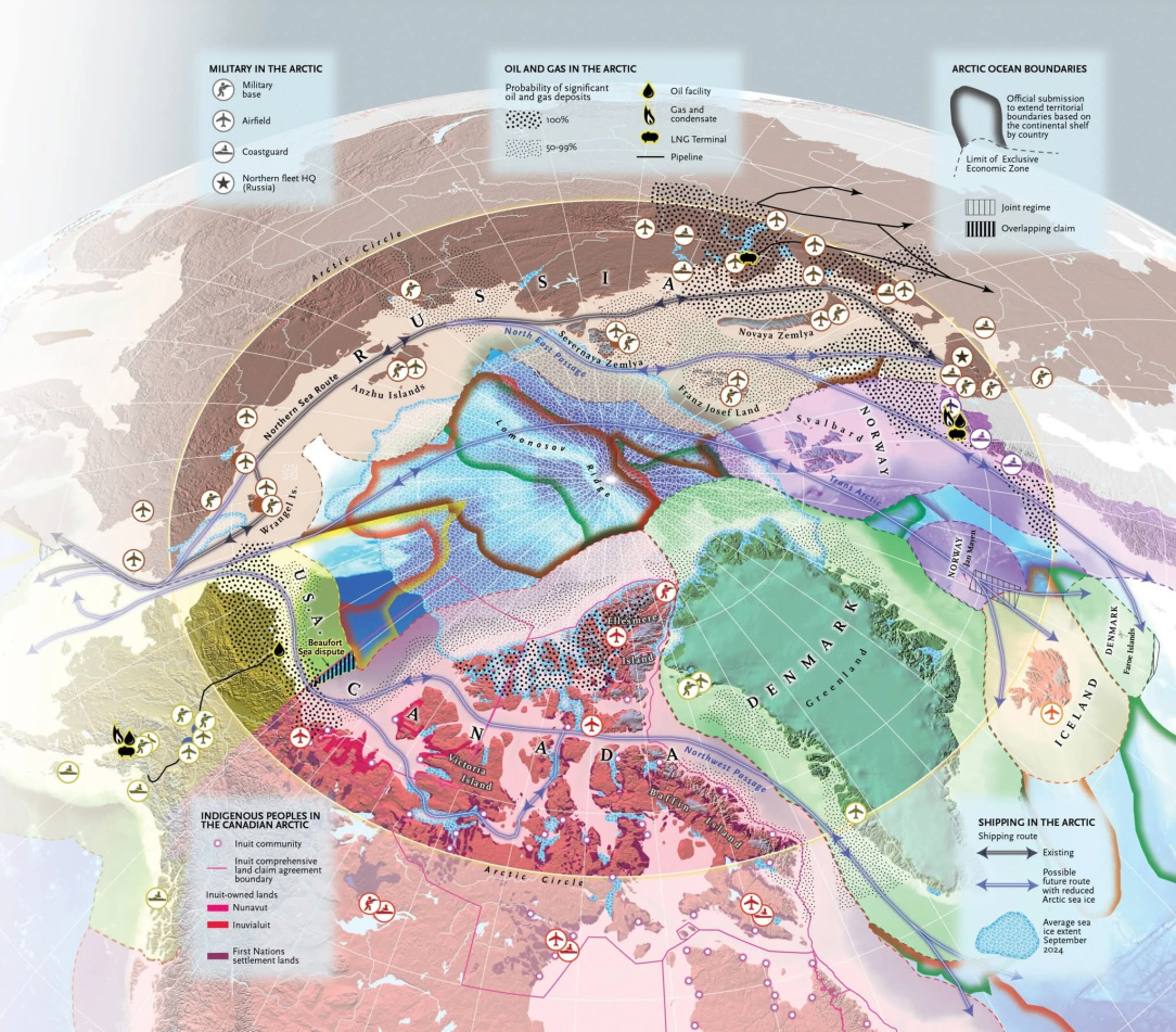
    Map of geopolitical and resource issues in wirhin the Arctic circle

    FB_IMG_1759187193399.jpg


  • Moderators, Social & Fun Moderators, Paid Member Posts: 14,017 Mod ✭✭✭✭JupiterKid


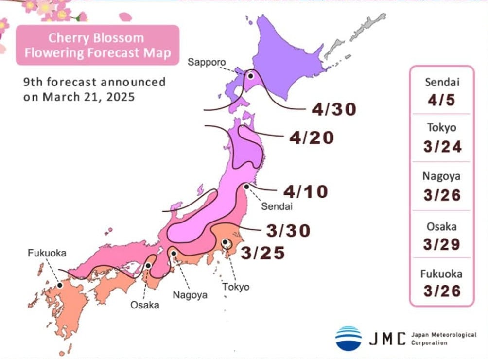
    Cherry blossom tree flowering forecast map of Japan, 2025

    FB_IMG_1759187916559.jpg


  • Advertisement
  • Moderators, Social & Fun Moderators, Paid Member Posts: 14,017 Mod ✭✭✭✭JupiterKid


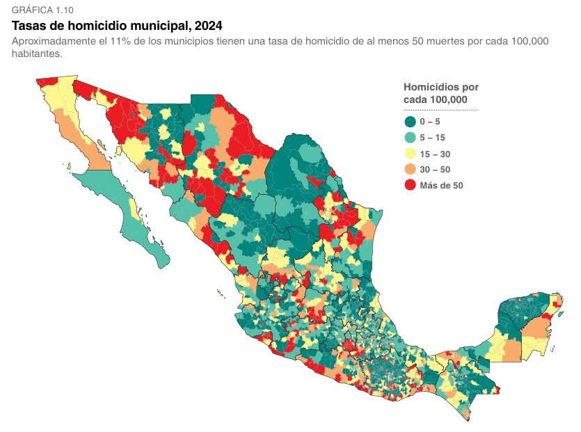
    Number of homicides per 100,000 population in Mexico by municipal authority area, 2024

    FB_IMG_1759187810264.jpg


  • Registered Users, Registered Users 2 Posts: 1,480 ✭✭✭OneEightSeven
    MEGA - Make Éire Great Again


  • Registered Users, Registered Users 2 Posts: 866 ✭✭✭minggatu


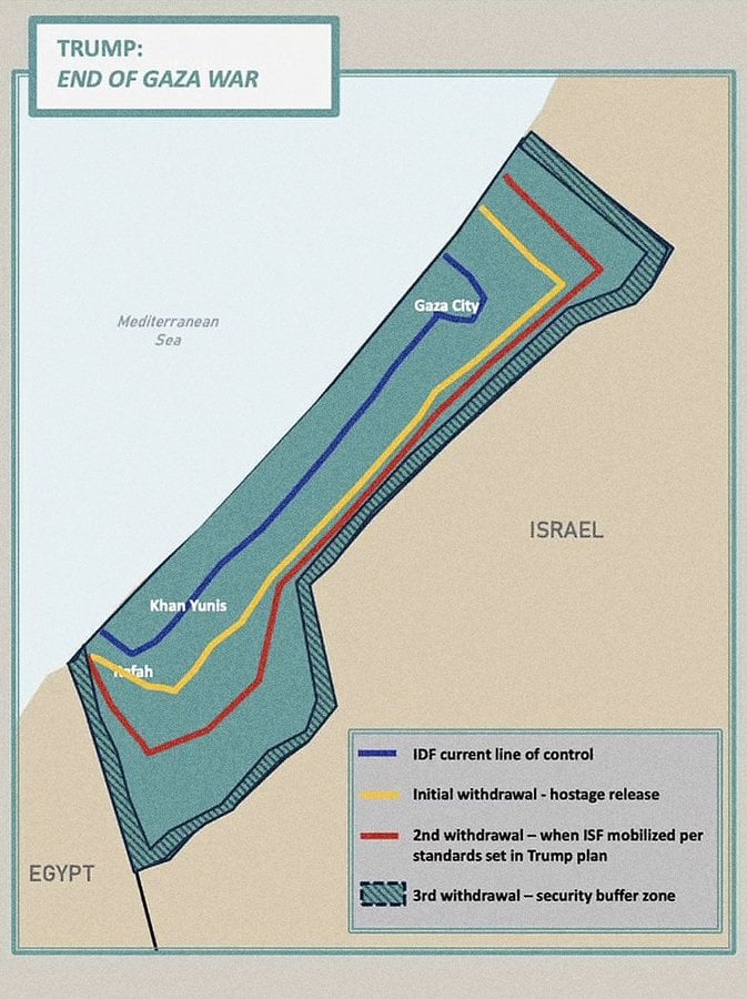
    Trump’s proposed Gaza withdrawal map, released by the White House

    G2DilxjaMAAoPQh.jpg

    https://x.com/amazingmap/status/1972825777877200968


  • Registered Users, Registered Users 2 Posts: 21,107 ✭✭✭✭gormdubhgorm


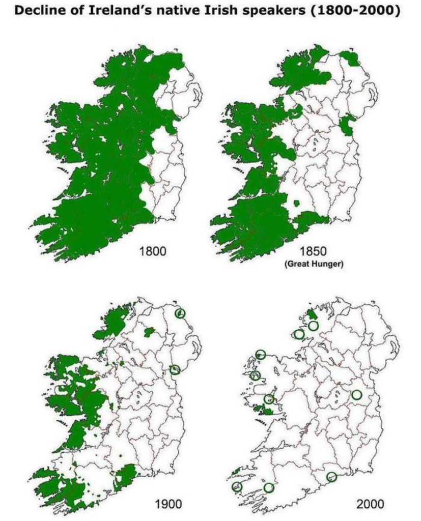
    Decline of Irish Language Speakers 1800-2000

    IMG_2383.jpeg

    Guff about stuff, and stuff about guff.


  • Registered Users, Registered Users 2 Posts: 866 ✭✭✭minggatu


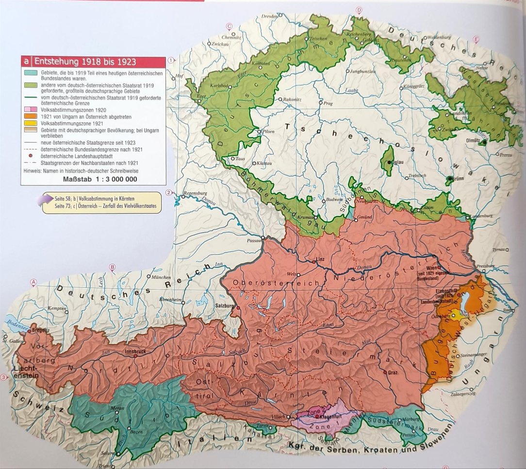
    The entirely impracticable Map of Austria Immediately After WW1

    G2GKUt5WEAABUl9.jpg

    https://x.com/BrilliantMaps/status/1973010207740486105/photo/1


  • Moderators, Politics Moderators, Paid Member Posts: 44,263 Mod ✭✭✭✭Seth Brundle


    …and I thought "Czechoslovakia" was tough to spell! 😳

    Help Keep Boards Alive. Support us by going ad free today. See here: https://subscriptions.boards.ie/ .


  • Registered Users, Registered Users 2 Posts: 1,480 ✭✭✭OneEightSeven
    MEGA - Make Éire Great Again


    556231668_18426168319100882_5799442965676016099_n.jpg

    ,,


  • Registered Users, Registered Users 2 Posts: 21,107 ✭✭✭✭gormdubhgorm


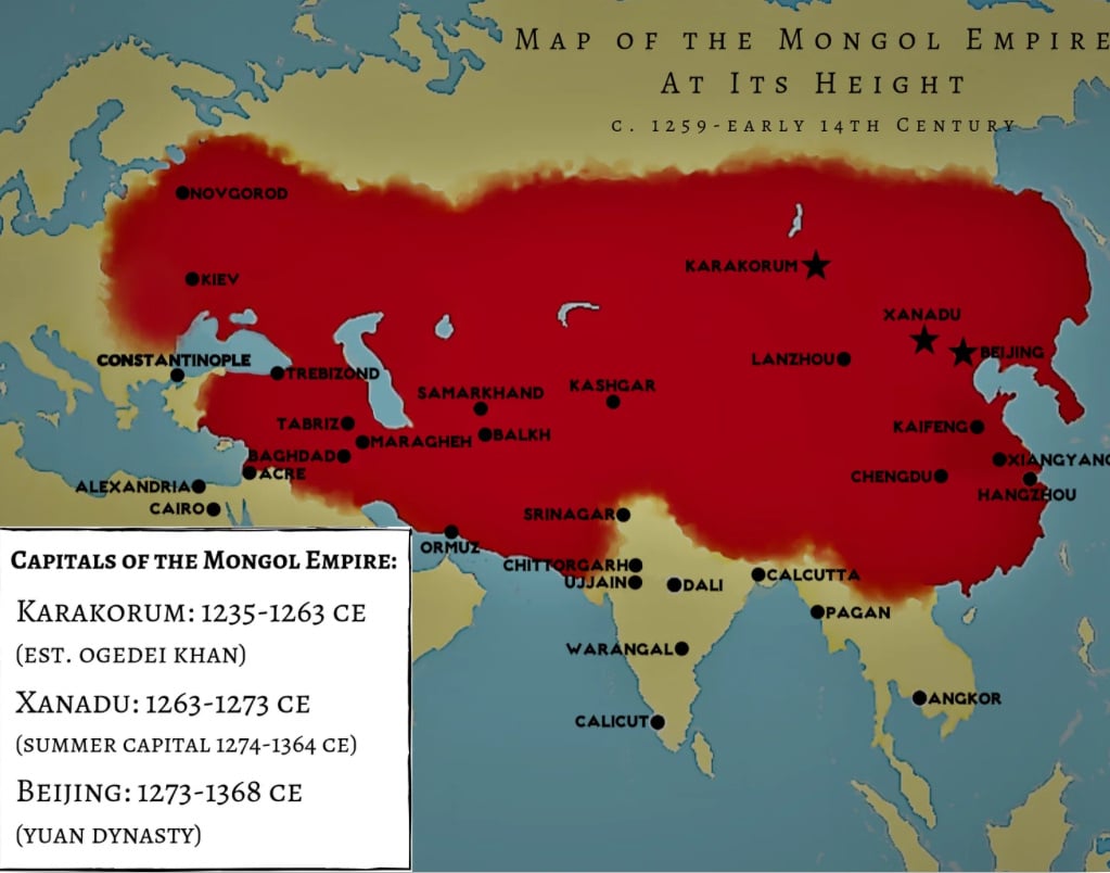
    The Mongol Empire c1259-early 14th Century

    IMG_2384.jpeg

    Guff about stuff, and stuff about guff.


  • Registered Users, Registered Users 2 Posts: 1,480 ✭✭✭OneEightSeven
    MEGA - Make Éire Great Again


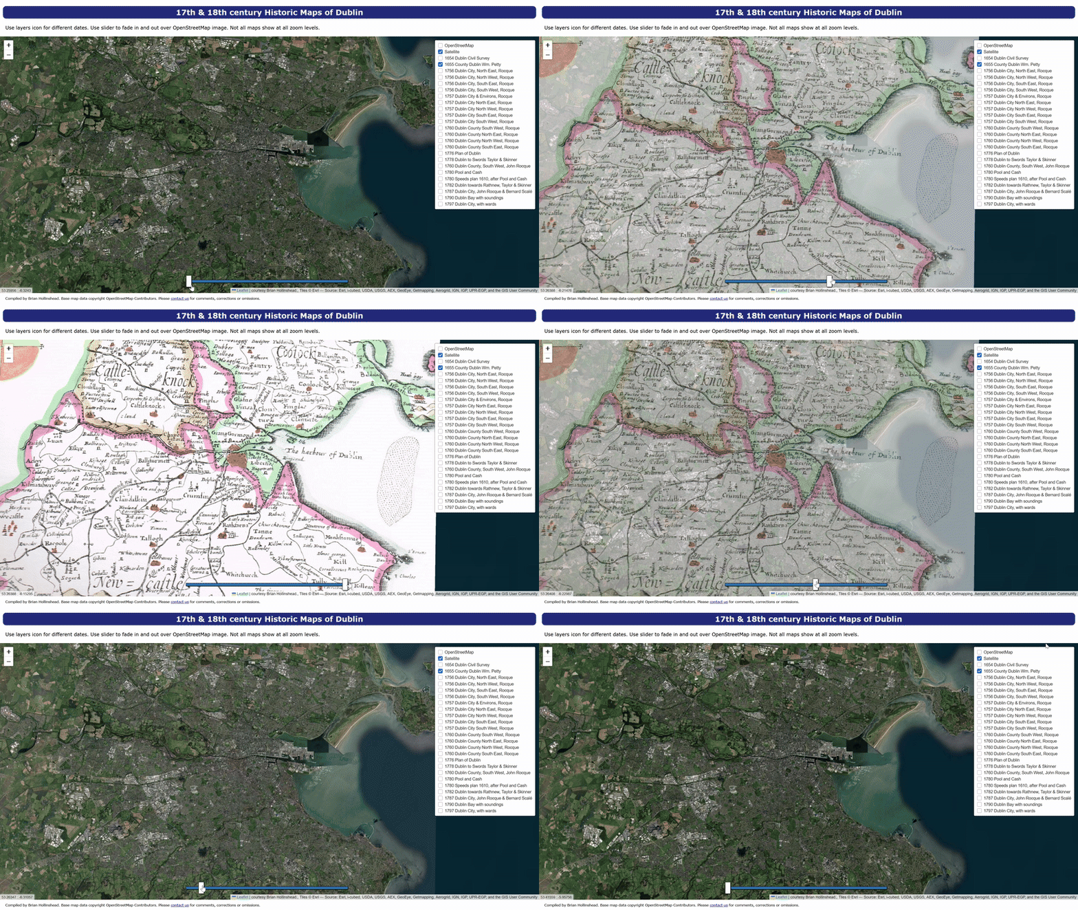
    Inspired by the Boston land reclamation map, I tried to create one for Dublin using Grok and ChatGPT. but no joy. Instead, you'll have to settle for a GIF. It's my first time recording my desktop screen and turning into a GIF, so it might not look good.

    Untitled Image


  • Advertisement
  • Registered Users, Registered Users 2 Posts: 32,428 ✭✭✭✭zell12


    So caller, almost six years and multiple duplicates later, does one wish to disclose their favourite map?


Advertisement