Advertisement
If you have a new account but are having problems posting or verifying your account, please email us on hello@boards.ie for help. Thanks :)
Hello all! Please ensure that you are posting a new thread or question in the appropriate forum. The Feedback forum is overwhelmed with questions that are having to be moved elsewhere. If you need help to verify your account contact hello@boards.ie
Hi there,
There is an issue with role permissions that is being worked on at the moment.
If you are having trouble with access or permissions on regional forums please post here to get access: https://www.boards.ie/discussion/2058365403/you-do-not-have-permission-for-that#latest

Ireland to Scotland boat size.

  • 21-01-2015 5:41pm
    #1
    Registered Users, Registered Users 2 Posts: 2,271 ✭✭✭


    I know very little about boats besides having worked on fishing boats for a number of years. I was just a deckhand, so no real skippering skills learned.

    I was looking at Google maps and I can see the shortest distance from Northern Ireland to Scotland is around 20km (12.5 miles).

    Im from a small Scottish island and it has been at the back of my mind for a while to think about travelling up from Carlingford (where I live) to the closest point, hugging the coast, and then heading across towards Campbelltown direction. Then heading up the Scottish coast.

    This is something I would want to do only when the weather is great and no changes predicted for a day or so. I would be in no rush to do the journey, I just would like to know the smallest motor boat that I could use that wouldn't endanger my life and have me ridiculed for doing something stupid.

    I am aware of the fact that by having to even ask this question, I am in no way ready to make that trip. I am asking because I would like pointers so that I can research more accurately online.

    I see the Shetland boats are class C, meaning they are suitable for up to 3 miles off the coast, so half way between Ireland and Scotland is 6 miles, so some advice on this would be great. What is the main reason a boat could go up to 3 miles out to see and not further? Is it because of potentially large swell? The conditions 3 miles out can be atrocious.

    If possible, could I have a boat that could be taken on a trailer so that I could keep it at my house when Im not in it.

    It would be a few months before I would have the funds, and Im hoping to have everything for around €5000. That is the boat, the engine and the trailer if indeed a suitable sized boat can be put on a trailer towed by a Land Rover.


Comments

  • Moderators, Motoring & Transport Moderators, Sports Moderators Posts: 6,344 Mod ✭✭✭✭fergal.b


    I guess there is no size limits lads have done it on surfboards :) I wouldn't be comfortable in anything smaller than 20 foot with a good powerful engine and back up engine, if you are just going for a quick spin maybe a rib or if you want a bit of comfort and somewhere to sleep a cuddy cabin. You should do a powerboat course a navigation course and a VHF before you make the trip.
    You can never trust the weather it can change at anytime and you can find yourself surrounded by fog even on the best of days.
    To be honest I would spend the first year getting to know the boat and water before heading out in open water or you could end up in a very cold place :)

    Keep asking questions and we will try and help you make the trip.


    .


  • Registered Users, Registered Users 2 Posts: 20,084 ✭✭✭✭neris


    a good rib will do it. Rib is probably safer aswellwith the weather and sea state. sea could become bumpy easily up in the north channel and a plastic tub is the last thing you wana be in plus a rib with good engine would have you making land fall in good weather in no time


  • Registered Users, Registered Users 2 Posts: 2,271 ✭✭✭TireeTerror


    Thanks for that.

    Do you know of any good online resources where I could study about tidal flows etc?

    On the fishing boats we generally used radar to navigate, but we did sometimes refer to charts to check for rocks hidden at low tide or when entering a harbour. This was all about 20 years ago, so it occurred to me that perhaps people would be using GPS on mobile phones to navigate at a budget, would that be the case?

    Are there any sea maps/charts for use on Android devices that use GPS instead of using the road maps, which are hardly suited to the job besides showing your exact location.


  • Registered Users, Registered Users 2 Posts: 4 Isilduhrr


    Better learn something (a lot even) about tides. The gulf of Corryvrecken will kick ass, even if you get it spot on.


  • Registered Users, Registered Users 2 Posts: 4 Isilduhrr


    Better learn something (a lot even) about tides. The gulf of Corryvrecken will kick ass, even if you get it spot on.

    Second thoughts: Try Carlingford to Skerries, Howth, Wicklow, Mann etc. Join a boat , sailing club. Not really a job for on-line learning and over-relying on things with batteries in them.

    (school of hard knocks speaks)


  • Advertisement
  • Registered Users, Registered Users 2 Posts: 2,271 ✭✭✭TireeTerror


    Isilduhrr wrote: »
    Better learn something (a lot even) about tides. The gulf of Corryvrecken will kick ass, even if you get it spot on.

    Yeah I went through the Gulf Of Corryvrecken in a force 8. We were leaving Loch Ryan heading to Oban. I was only 17 at the time, so mortality was not a major thought. The skipper had been fishing all his life, but that day was a little frightening to say the least. There were times when it wouldve almost been easier to stand on the side of the wheelhouse than stay in the seat upright.

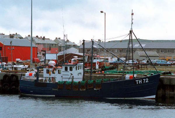
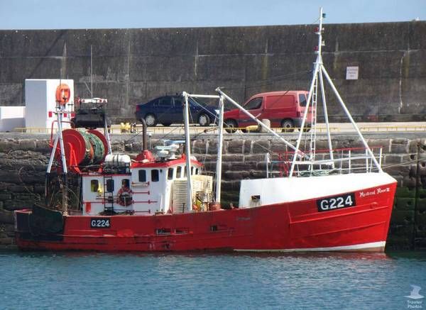
    Feeling all reminiscent after typing this, I googled for some images and after a bit of reading discovered that she has changed from TH72 Seven Sisters to Mystical Rose II G224 and has been in Ireland for some time! I was on her for 1 year and actually lived on her non-stop for around 5 months at one point doing a survey on the viability of dog whelk (Buckie) fishing off the Scottish coast. In the photo where she is blue, that is exactly as I remember her, since her journey to Ireland she has had a lot of changes.

    th72.jpgg224.jpg

    Sorry about going off topic, I got a bit carried away with myself there and I suddenly feel very old at 37!


  • Site Banned Posts: 638 ✭✭✭imurdaddy


    It might be worth looking into dayskipper course and sailboat option! It would be doable with some experience and you could buy a trailer sailor with swing keel something like leisure 20 would be very good sea boat, plus with sail you wont spend a fortune on fuel. Experience can be got crewing in local clubs and eventually coastal trips port to port.


  • Registered Users, Registered Users 2 Posts: 378 ✭✭catastrophy


    Ah, I see why you were asking about Shetlands now :)

    Being honest and while it's entirely possible I wouldn't do that trip in a Shetland. My experience is very limited but most Shetlands are excellent cruisers, however in a swell are out of their comfort zone.

    Personally I'd want an "unsinkable" hull. Something like a warrior 175.

    I've known a few who have done the Rosslare to Fishguard route (I'd love to do it myself some day) and they have all been in sail boats.


  • Registered Users, Registered Users 2 Posts: 20,084 ✭✭✭✭neris


    Thanks for that.

    Do you know of any good online resources where I could study about tidal flows etc?

    On the fishing boats we generally used radar to navigate, but we did sometimes refer to charts to check for rocks hidden at low tide or when entering a harbour. This was all about 20 years ago, so it occurred to me that perhaps people would be using GPS on mobile phones to navigate at a budget, would that be the case?

    Are there any sea maps/charts for use on Android devices that use GPS instead of using the road maps, which are hardly suited to the job besides showing your exact location.

    Paper charts might not be cool anymore but they are far more detailed and easier to see obstructions etc on then an electronic chart. (just see vestas). While some of the charts on ipads and phones are great and give great detail such as tides and SOG they have a certain battery life. At least with paper back up when the electronics die you can identify lights & marks


  • Moderators, Recreation & Hobbies Moderators, Sports Moderators Posts: 15,788 Mod ✭✭✭✭Tabnabs


    The North Channel has strong tides and can also have a big Atlantic swell coming in. There's plenty of commercial traffic and having been into Campbeltown a few times (on a big ship) and worked with a Campbeltown lad at sea, they're a funny bunch and it's not somewhere I'll ever be bothered to go back to.

    A big Rib (7m+) or a 30ft mobo, or alternatively a 26+ft yacht is the smallest I'd like to do that trip in. In good weather, a fantastic journey, but this is Scotland we're talking about and fog/rain/wind could make it an equally miserable experience.


  • Advertisement
Advertisement