Advertisement
If you have a new account but are having problems posting or verifying your account, please email us on hello@boards.ie for help. Thanks :)
Hello all! Please ensure that you are posting a new thread or question in the appropriate forum. The Feedback forum is overwhelmed with questions that are having to be moved elsewhere. If you need help to verify your account contact hello@boards.ie

Paleolicthic Ireland ? what you aren't told in school

Options
  • 24-11-2013 12:34am
    #1
    Registered Users Posts: 4


    it's a bias issue but whats the thinking behind early palaeolithic man in Ireland . list of animales in Ireland during that time priod . Wolves 33,000 bc Bears 50,000 years ago . Hyenas 30,000 years ago Irish elk ,mamouths the list go's on .

    so theres no problem food wise . and it wasin't cold in places like dungarvan and cork the bottom of Ireland was not effected by the cold unlike ulster which was covered in huge ice sheets simliier to nothern Britian . humans where in walse and nothern france so clealr they knew of Ireland . Ireland was attach and re attach mutible times to main land europe . any histrion worth there salt will tell u it probably did happen but evidence isn't in huge supply . a couple of tools have been found 400,000 year old hand axe couple of bits of flint . but the hand axe could have been caried on a ice sheet . all though it could have arrived from ice free zones from another part of Ireland .

    even if we ignore the evidence of hand axes and flint pieces ,it still seems very unlikely that it didin't happen . imagine these people would have lived on mostly Irish elk as that seems to be in huge supply here hunderds if not thousands of these bones have been found ,they probably eat other stuff to . so im nick naming them the elk people :P we see Ireland becoming attach to main land europe mutible times from 33,000 bc to 20,000 bc to 17,000 bc . so it must of happened . but genraly it's ignored by some histrions .we also see artic foxes dieing off about 20,000 years ago with climates inceasing getting warmer again .

    personaly neathandertals are a bit of a cope out , infact people returned to Britian about 9,000 years ago . what ever was there before was long dead . but never the less . :D


«1

Comments

  • Moderators, Science, Health & Environment Moderators Posts: 5,218 Mod ✭✭✭✭slowburner


    hiberni wrote: »
    it's a bias issue but whats the thinking behind early palaeolithic man in Ireland . list of animales in Ireland during that time priod . Wolves 33,000 bc Bears 50,000 years ago . Hyenas 30,000 years ago Irish elk ,mamouths the list go's on .

    so theres no problem food wise . and it wasin't cold in places like dungarvan and cork the bottom of Ireland was not effected by the cold unlike ulster which was covered in huge ice sheets simliier to nothern Britian . humans where in walse and nothern france so clealr they knew of Ireland . Ireland was attach and re attach mutible times to main land europe . any histrion worth there salt will tell u it probably did happen but evidence isn't in huge supply . a couple of tools have been found 400,000 year old hand axe couple of bits of flint . but the hand axe could have been caried on a ice sheet . all though it could have arrived from ice free zones from another part of Ireland .

    even if we ignore the evidence of hand axes and flint pieces ,it still seems very unlikely that it didin't happen . imagine these people would have lived on mostly Irish elk as that seems to be in huge supply here hunderds if not thousands of these bones have been found ,they probably eat other stuff to . so im nick naming them the elk people :P we see Ireland becoming attach to main land europe mutible times from 33,000 bc to 20,000 bc to 17,000 bc . so it must of happened . but genraly it's ignored by some histrions .we also see artic foxes dieing off about 20,000 years ago with climates inceasing getting warmer again .

    personaly neathandertals are a bit of a cope out , infact people returned to Britian about 9,000 years ago . what ever was there before was long dead . but never the less . :D
    Clearly something else was omitted from the teaching of this school.
    We had a thread on this subject some time ago but feel free to discuss, it's an interesting question.


  • Registered Users Posts: 1,752 ✭✭✭markesmith


    It makes sense that Ireland was inhabited in Palaeolithic times, what with the land connection to Britain / NW France and the warmer climate in the South.

    I think too little archaeological work has been carried out in the South - the lucky finds of Sandel and the Ceide Fields have skewed Ireland's early history in those areas. Even Boora doesn't get the credit it deserves.

    Oppenheimer's Origins of the British deals with this a little, stating that Palaeolithic intrusions into Britain survived in small numbers even during the last Ice Age. Not sure if the persistence of those genes in Ireland are due to later emigration from Britain, or if those genes were descended from Palaeo settlers in what is now Munster.

    It's a fascinating question, and it's would put the human history of Ireland back so many thousands of years it's difficult to understand.

    My money's on the fact that mankind walked under forest canopy long before we believe they did.


  • Closed Accounts Posts: 5,995 ✭✭✭Ipso


    Oppenheimers book is severly out of date now. The big male lineage he said that came from Iberia is now thought to have originated somewhere between the Balkans and North Iran and got to Ireland in the late Bronze Age.
    It then expanded under the gaelic chieftans most likely due to their illegitimate sons having rights under the laws at the time.


  • Registered Users Posts: 3,284 ✭✭✭dubhthach


    Ipso wrote: »
    It then expanded under the gaelic chieftans most likely due to their illegitimate sons having rights under the laws at the time.

    "illegitimacy" isn't a feature of Gaelic Irish society. As far as our ancestors were concerned a son by a wife and a son by another woman were equal under the law. In many ways it was a more modern way of thinking then we have today. (Most marriages of "landed elite" were Civil as opposed to religious)


  • Registered Users Posts: 310 ✭✭dublinviking


    what can we do with all the R1b in Africa?

    http://www.eupedia.com/forum/threads/26626-R1b-in-Africa

    And these things:

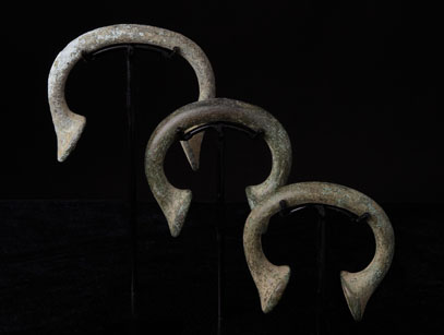
    African%20currency%20Manilla%20small%2019.jpg

    220px-2005_0101MusAlbertandVictoria0138.JPG

    They are called manilas and originate in west africa

    http://en.wikipedia.org/wiki/Manillas


    http://en.wikipedia.org/wiki/Torc

    Interesting and not really talked about...Who came from where?


  • Advertisement
  • Registered Users Posts: 310 ✭✭dublinviking


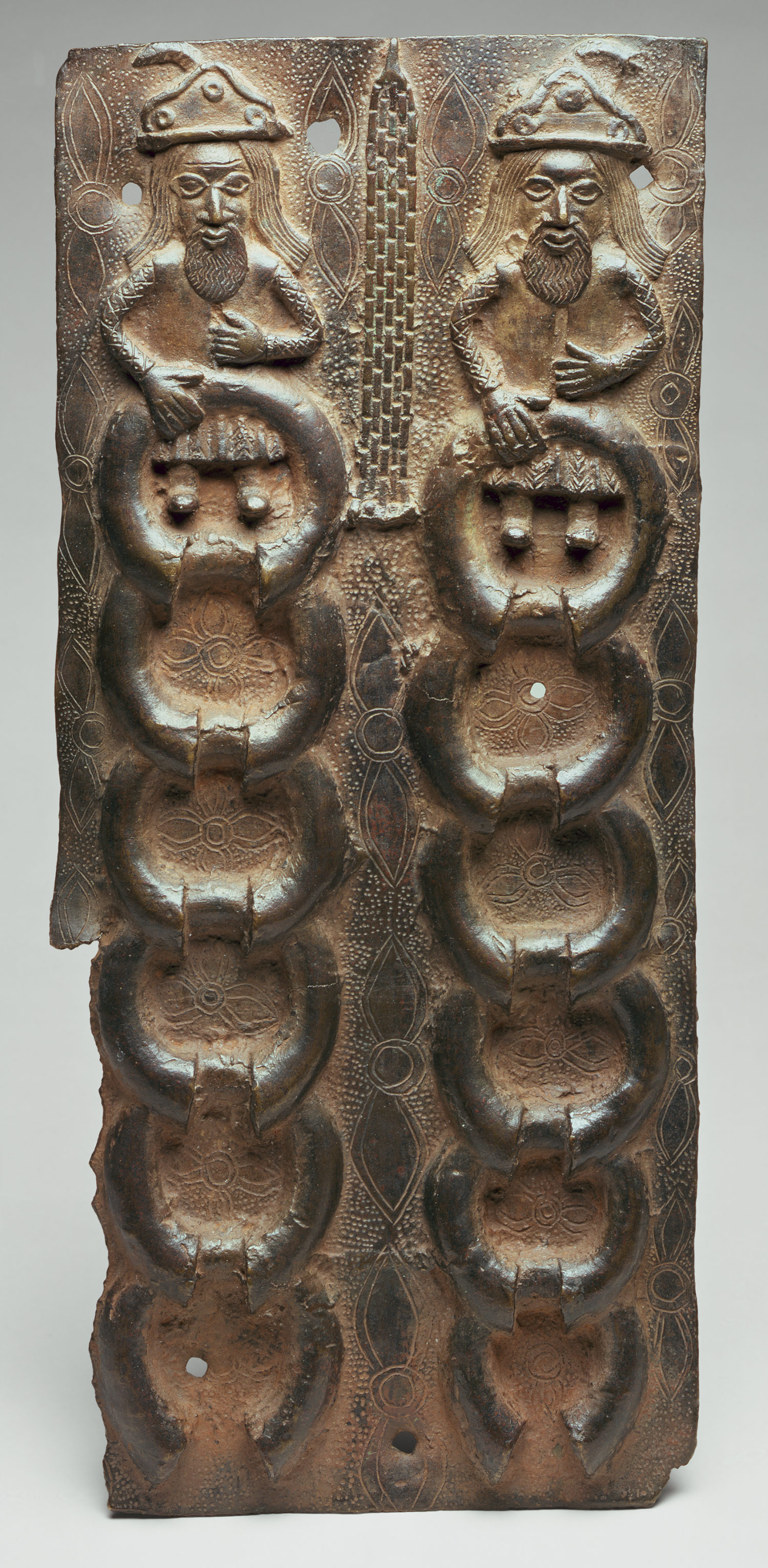
    african bracelet money

    bDuchBeninS60.jpg

    images?q=tbn:ANd9GcRLcJNwqVREYZViWpmCWAVcm9PzndB_fVA0DrMs5Oam7d49It-0

    h2_1991.17.13.jpg

    http://coincoin.com/I062.htm


  • Closed Accounts Posts: 5,995 ✭✭✭Ipso


    African R1b is V88 and is well upstream from M269 (the one that dominates Western Europe), which is 8,000 to 10,000 years old anyway.


  • Registered Users Posts: 310 ✭✭dublinviking


    i know. However this does not explain african r1b and african torcs. A man holding exactly the same torcs can be seen on a relief showing Scythians bringing presents to persian king

    sakas_persepolis.jpg

    http://www.cais-soas.com/CAIS/Anthropology/Scythian/saka_nomenclature.htm

    How do we explain this? Scythians invaded africa? Irish invaded africa? R1b originates in africa and then moves to central asia and then to ireland? Something else? Interesting anyway...And not taught in schools...:)


  • Registered Users Posts: 3,284 ✭✭✭dubhthach


    Haplogroup MP
    ----> Haplogroup M (New Guinea)
    ----> Haplogroup P (probably arose in SE. Asia)
    > Haplogroup Q (Eastern Siberia + Native Americans)
    > Haplogroup R
    > Haplogroup R1
    > Haplogroup R1a
    > Haplogroup R1b
    > Haplogroup R1b1a2 (M269) -- 110million Europeans
    > Haplogroup R1b1c* (V88) -- Africa, M. East
    > Haplogroup R2


    M269 and V88 probably shared a common ancestor sometime during the Stone age, in case of V88 it's expansion in Africa is linked with the Chadic language family.

    It's thus a parallel subclade under wider R1b (Specifically R1b1-P25), the two branches would have gone their separate ways in the middle East.

    From what we know of Scythian ancient DNA they tend to be more R1a -- which is dominant Haplogroup among more eastern Indo-European languages (Slavic, Indic, Iranic etc.)


  • Registered Users Posts: 310 ✭✭dublinviking


    From what we know of Scythian ancient DNA they tend to be more R1a -- which is dominant Haplogroup among more eastern Indo-European languages (Slavic, Indic, Iranic etc.)

    I know. I wrote about it. And this is where we have a problem with manillas. Look at the reliefs from africa. Don't they look central asian to you?

    The only R* population found in africa is R1b. And scythians are R1a.

    I am not making conclusions just throwing this in so people can think about it.


  • Advertisement
  • Registered Users Posts: 310 ✭✭dublinviking


    Here is an interesting work that i stumbled across few years ago.

    It claims that once there was a culturally unified Atlantic civilization covering north west africa, west mediteranean and western Europe. That these atlantic Europeans crossed atlantic 4000 bc, established large copper mining colonies in the great lakes area and kept the link until roman time.

    http://www.provincuns.com/books/berber-project.pdf

    The places where we find megalith cultures in north east America (great lakes) are the same areas where we find large, unexplained, amount of european dna in native population.
    In the Americas, it is not a pre-Columbian founding lineage. The presence of R-M173 in the Americas is probably partly or wholly the result of Eurasian admixture (Malhi 2008 and Lell 2002). However, it is the second most common haplogroup in Indigenous peoples of the Americas following haplogroup Q-M242, and spreads specially in Algonquian peoples from United States and Canada (Malhi 2008).

    http://en.wikipedia.org/wiki/Haplogroup_R-M207

    Interested?

    Here is an excerpt:
    ...Amalgamation, Mixing, and Intermingling

    Indo-Europeans invaded Germany from the southeast around 3000 BC, and here they intermingled with the local Berbers, "producing a number of mixed cultures in the process," as far south as Switzerland (Owen, 31). Owen refers to this as an "amalgamation" of the Berber and Indo-European peoples (Owen, 45). By 1700 BC, a new culture had appeared in Denmark, southern Sweden, and northern Germany, known as the "Northern Bronze Age." German archaeologist Herbert Schutz notes that this Bronze Age culture arose from the "intermingling of groups of people," including the Indo-European migrants from the east, and the "megalith-builders," whose Berber background is well- established (Schutz, 155). Beyond a doubt the Northern Bronze Age was "the ancestral civilization of the Germanic peoples" (Skomal, 218f), so the link between Berbers and Germans has been proven. Or, at the very least, it has been established as a reasonable working hypothesis. It is not some bizarre tangent or Erich von Dänikenesque lunacy. It is a scientific theory with professional support.


    Germanic peoples speak Germanic languages, and it has long been recognized that a substantial pre-Indo- European component exists in those languages. Piergiuseppe Scardigli estimates that a full 40% of the basic ancient Germanic vocabulary is not Indo-European, but rather comes from some other source. This includes such basic words as land, rain, path, silver, and word (Scardigli, 103f). Edgar Polomé finds it "obvious" that Germanic retains traces of the language spoken by the pre-Indo-European inhabitants of Denmark and northern Germany (Polomé 1986, 661).


    Are there any linguistic links between Berber and German? Berber, like the related Semitic languages, uses vowel mutation to express a change of meaning. Thus amagur (camel) becomes imugar (camels). This same feature is characteristic of Germanic languages as well; thus English man/men, foot/feet, write/wrote, etc. In The Loom of Language, Bodmer observes that Germanic and Semitic share this distinctive feature (Bodmer, 429) which is, needless to say, uncommon in other Indo-European languages. Based on its traces in Germanic, Eric Hamp reconstructs the pre-Indo-European language of northern Europe as one in which there was a four-vowel system with no distinct "o," and which used the same words for deictic and relative pronouns (Markey and Greppin, 296ff). Guess what? Berber has a four-vowel system with no "o" and uses the same words for deictic and relative pronouns.


    Many pre-Indo-European root words surviving in Germanic can be traced back to an Afro-Asiatic source (the parent language family of Berber). An excellent example is the word silver, which comes from Berber azerfa. This term was apparently spread throughout Western Europe by the Beaker Folk, who traded in silver (Cardona, 293). Berber words in Germanic include:


    EARLY GERMANIC ~ AFRO-ASIATIC (Proto-Berber)

    baus (bad, evil, useless; German böse) ~ ba's (calamity, misfortune)
    ela (eel) ~ 'il (snake)
    gawi (district; German Gau) ~ gawad (land, with epenthesis)
    kelikn (loft, upper story) ~ qal'a (fortress, hill, citadel [Skomal, 223ff])
    land (land, country) ~ lha'nt (grassland, with collective suffix)
    paþa (path) ~ put (to step along)
    preu (awl, piercing tool) ~ par (to separate, cut apart, make an opening)
    regen (rain; German Regen) ~ rayyn (well-watered, with noun suffix)
    sek (to cut, mow; English sickle) ~ tsîk (to pluck up)
    silver (silver) ~ azerfa (silver)
    summer (summer) ~ asammar (hot weather)
    werð (word) ~ werd (to call out)

    Germans are not the only West European nation deeply influenced by Berber culture. Celtic is especially rich in Berberisms. Even a common Irish word like aue, "grandson," comes from the Berber aouwi, "son." This is, by the way, the root of the Irish prefix Ó, still found in Irish names like O'Reilly this most common "Irish" word is actually Berber! Irish tribal names like Uí Máine, Uí Faoláin, and Uí Néill, seem to have been patterned after the Berber collective prefix found in Ait Frah, Ait Ouriaghel, and Aït Ndhir (Adams 1975, 240ff). According to world-renowned scholar Julius Pokorny, it is "from every point of view impossible" that the Celts were the earliest inhabitants of Ireland; the Berbers came first (Pokorny, 229). He reminds us that the Megalithic inhabitants of Éire were long- headed Mediterraneans, who "still form the principal element in the population of North Africa." There are many customs in common between Celts and Berbers, Pokorny assures us, including "queer sexual morals" (Pokorny 232f). Welsh scholars have also affirmed "the kinship of the early inhabitants of Britain to the North African white race" (Sergi, 246), while the linguistic evidence of nouns, verbs, infixed pronouns, pre-verbs, consonant quality, and lenition of consonants all proves "close relations between Berber and Insular Celtic" (Pokorny, 236ff). Talossans of Celtic descent can rejoice in their Berber ancestry too.


    Especially in their syntax, Celtic, Spanish, Basque, Portuguese, French and English have all been deeply affected by this same "Atlantic" substratum, which Gessman calls "almost certainly Hamitic" (Gessman, 7). And so, although modern Talossans might not knowingly speak a word of Berber (or Talossan), every time we open our mouths to speak, we confess our ancient Berber heritage!


    Not my area of interest but probably important for irish people i would say. Bob Quin talked about this Barber link in his book and tv series Atlantean irish...

    But it seems that these old Berbers and atlanteans were R1a...The old R1a which brought the old European language to Ireland that i talk about in vinca thread...

    http://s1.zetaboards.com/anthroscape/topic/3944556/1/


  • Registered Users Posts: 310 ✭✭dublinviking


    Or were R1a megalith builders, and R1b or E1 bringers of Afro Asiatic language to Europe? Questions questions...


  • Moderators, Science, Health & Environment Moderators Posts: 5,218 Mod ✭✭✭✭slowburner


    Here is an interesting work that i stumbled across few years ago.

    It claims that once there was a culturally unified Atlantic civilization covering north west africa, west mediteranean and western Europe. That these atlantic Europeans crossed atlantic 4000 bc, established large copper mining colonies in the great lakes area and kept the link until roman time.

    http://www.provincuns.com/books/berber-project.pdf

    The places where we find megalith cultures in north east America (great lakes) are the same areas where we find large, unexplained, amount of european dna in native population.


    http://en.wikipedia.org/wiki/Haplogroup_R-M207

    Interested?

    Here is an excerpt:


    Not my area of interest but probably important for irish people i would say. Bob Quin talked about this Barber link in his book and tv series Atlantean irish...

    But it seems that these old Berbers and atlanteans were R1a...The old R1a which brought the old European language to Ireland that i talk about in vinca thread...

    http://s1.zetaboards.com/anthroscape/topic/3944556/1/

    Quite interesting but entirely unconnected to the subject of the thread. Please try to stay on topic, thanks.


  • Registered Users Posts: 310 ✭✭dublinviking


    sorry. do you want to open a new thread and put all this into new thread if you think it would help.


  • Registered Users Posts: 1,752 ✭✭✭markesmith


    What are your thoughts on Paleolithic Ireland, dublinviking?

    Your posts on this thread, while interesting as always, are not relevant to the topic at hand.


  • Registered Users Posts: 310 ✭✭dublinviking


    ok guys i apologized and asked moderator to move my "spam" to another thread. I was following thought: this is thread about things related to paleolithic and mesolithic and neolithic things they don't teach you at school so i posted things related to mesolitic and neolithic period.

    As for paleolithic, unless there was a solid permanent land bridge, there was no way for humans to survive in Ireland before 10,000 bc. Why 10,000 bc? Because about that time first fully functional hafted chopping axe was invented. And soon after first chopping axe was invented, people started making one thing you can't make without a proper chopping axe: dugout canoes. This changed the world completely, turning water from water barrier, to water way.

    People could not have survived whole year round in the north of europe within 100,000 - 10,000 bc. Even today they can barely do it, with proper clothing and shelter and plenty of food supplies. It is impossible for hunter gatherers reliant even partially on plant food to survive in snow deserts of winter northern Europe. So people most likely migrated: up north during the summer, down south in the winter. And you can't do that without a land bridge.

    Have a look at this

    http://webir.tcd.ie/bitstream/2262/40560/1/Edwards%26Brooks_INJ08_TARA.pdf

    If it is true that there was actually no land bridge since 16,000 bce, then you have no chance of finding anything in Ireland worth looking at from before 10,000 bce. If there were humans present in Ireland in the period before 100,000 bce, it was probably small scale temporary presence. And that was all wiped out by ice and flooded when water rose later on. You need to think of the world from that period as a huge empty land full of food. People didn't need to live in Ireland. So just because they could, does not mean anyone bothered...:)

    Again sorry for "spamming" but i thought if we don't know who lived in Ireland in Neolithic...


  • Moderators, Science, Health & Environment Moderators, Society & Culture Moderators Posts: 60,075 Mod ✭✭✭✭Wibbs


    As for paleolithic, unless there was a solid permanent land bridge, there was no way for humans to survive in Ireland before 10,000 bc. Why 10,000 bc? Because about that time first fully functional hafted chopping axe was invented. And soon after first chopping axe was invented, people started making one thing you can't make without a proper chopping axe: dugout canoes. This changed the world completely, turning water from water barrier, to water way.
    Not quite DV. People made it to Australia 60,000 years ago across a water barrier. Flores "Hobbits" made it to Flores way before that across some of the strongest currents in one of the most hazardous straits in the world, as did Erectus. It's looking increasingly likely that Neandertals made it to Crete and that is way out of sight of land from the continent. Water in many cases it seems wasn't the barrier once thought.
    People could not have survived whole year round in the north of europe within 100,000 - 10,000 bc. Even today they can barely do it, with proper clothing and shelter and plenty of food supplies. It is impossible for hunter gatherers reliant even partially on plant food to survive in snow deserts of winter northern Europe.
    Well Neandertals were in Norfolk in the UK 50,000 years ago when IIRC there was a landbridge still connected to Ireland. MOderns were in the UK 28,000 years ago. In north western Scotland where on a clear day even today you can see our fair isle they found handaxes/bifaces made by earlier people(likely Erectus) going back 300-400,000 years. The earliest presence of humans in Britain is nigh on 900,000 years back. Now if we take the UK model, it seems yes the ice beat them back, but anytime there was any sort of a lull and the weather warmed up(and sometimes it warmed up to higher temps than today) our ancestors were in like Flynn. Resourceful amazing buggers to be sure. TBH I have a real deep admiration for these various peoples(and I fully consider them that) as they were rocking some incredible cahonies*.

    So I fully believe humans, especially pre modern folks were here and more than once and I'd bet the farm they lived, raised kids and died here as "Irish" men and women in those longer warm periods. Sadly the glaciers that spared southern England really scraped us bare of so much evidence. Not just of human age stuff, but going well back, all the way down to the Carboniferous rocks.


    Good and interesting link BTW DV. Well worth a peruse.


    *it may sound daft, but it's one reason why I have collected their lithics since I was a kid. You hold one and it still fits the human hand, is usually still sharp and actually bloody usable and I like to think "hey oul son, we've walked on other worlds and are looking at the nature of reality itself and it's because of you guys and gals. Thanks". I know, I told you, daft, but there you go. Plus when you try to make one, being all advanced and modern and stuff, you quickly realise this stuff ain't easy. At all. Unless you're jimmyarch and he can feck off! :D

    Rejoice in the awareness of feeling stupid, for that’s how you end up learning new things. If you’re not aware you’re stupid, you probably are.


  • Registered Users Posts: 310 ✭✭dublinviking


    Hi Wibbs

    I love your enthusiasm. And i hope that one day you might find that elusive piece of stone that will prove that people lived in Ireland before 10,000 bc. I am not saying that it is impossible. All you say about how close northern ireland is to the scotish paleo finds is true. but i really doubt that people were able to cross any expence of water few hundred thousand years ago. If ireland was an island then, all they could have done was to stand in scotland and look at ireland and wander what the heck was that thing there.
    Not quite DV. People made it to Australia 60,000 years ago across a water barrier. Flores "Hobbits" made it to Flores way before that across some of the strongest currents in one of the most hazardous straits in the world, as did Erectus. It's looking increasingly likely that Neandertals made it to Crete and that is way out of sight of land from the continent. Water in many cases it seems wasn't the barrier once thought.

    I know about all this. And it is really a puzzle. Even for people who claim that people did all this, they have no idea how, as human technology found in related sites does not enable people to make sea worthy or any water worthy crafts. Were there some land bridges that we don't know about? Some that sunk due to earthquakes? In montenegro in seventies whole towns sunk under the see in one day during an earthquake. We know of numerous towns around the world that had the same fate. Crete is notorious for it earthquakes. And the level of mediteranean sea was much lower, so a lot of mediteranean sea was dry and islands were mountain ranges. Could it not have happened that people ended up walking to these places over now sunken land bridges?

    to make a craft is not easy. not even a raft. you need to be able to cut big trees, make strong cordage, sales, or at least oars, which would require advanced carpentry tools and skills. This is not found in the archaeological material from these areas from that time. Yet after 10,000 bce we find it everywhere. What changed? hafted axe was invented.

    It doesn't make sense from a technological, engineering point of view that people were able to make and use floating means of transportation that early.

    This doesn't mean that they might not find the material proof that people did have the required technology. In which case happy days. Until then...


  • Registered Users Posts: 310 ✭✭dublinviking


    Now if we take the UK model, it seems yes the ice beat them back, but anytime there was any sort of a lull and the weather warmed up(and sometimes it warmed up to higher temps than today) our ancestors were in like Flynn. Resourceful amazing buggers to be sure. TBH I have a real deep admiration for these various peoples(and I fully consider them that) as they were rocking some incredible cahonies*.

    Couldn't agree more. People are resourceful opportunistic creatures. But precisely because people are opportunistic they will not stay up north during the winter in the cold with no food, if they can move down south where it is warm and there is plenty of food. They have no reason to do so. No borders, no land ownership, no competition for resources. The land was empty. And they had nothing to tie them to one place. Except if the land bridge they used to get to that place collapsed or sunk, in which case they were buggered. And this probably happened in Ireland at least once. I believe that we have best chance of finding what you are looking for not on land, but in water off the coast of the south Ireland, somewhere between the fingers of kerry or in the inlets of west cork...The submerged land...


  • Registered Users Posts: 310 ✭✭dublinviking


    This is some material i collected while looking into dating of the earliest hafted axe.

    Here is flint knapper Ed Mosher demonstrating the use of his handmade stone axe on a tree (a smallish one):

    http://www.youtube.com/watch?v=6e9auy5jLB4


    To cut a tree you need an axe with a handle in order to produce enough cutting force.
    Initially axes were probably not hafted. The first true hafted axes are known from the Mesolithic period (ca. 6000 BC). Axes made from ground stone are known since the Neolithic. Few wooden hafts have been found from this period, but it seems that the axe was normally hafted by wedging. Birch-tar and raw-hide lashings were used to fix the blade.

    http://en.wikipedia.org/wiki/Axe

    This means that before that there was basically no way to cut a big tree down. This is confirmed by the age of the oldest dugout canoes which date to 6000 bc:

    http://en.wikipedia.org/wiki/Dugout_(boat)

    Here are some documentaries about building a dugout canoe using metal hand tools, much sharper than old stone tools:

    finland:

    http://www.youtube.com/watch?v=kW7BdhOZZ_c

    some tribesmen building a dugout canoe:

    http://www.youtube.com/watch?v=Su80f26u7P8

    great university research project video about making dugout canoe. Shows limitations of hand tools.

    http://www.youtube.com/watch?v=rn2NEdDeHKI

    But people built boats from branches and bark even earlier:
    The word canoe comes from the Carib kenu (dugout), via the Spanish canoa.[3]

    Constructed between 8200 and 7600 BC, and found in the Netherlands, the Pesse canoe may be the oldest known canoe. Excavations in Denmark reveal the use of dugouts and paddles during the Ertebølle period, (ca 5300 BC – 3950 BC).[4]
    Australian Aboriginal people made canoes using a variety of materials, including bark and hollowed out tree trunks.[5] The indigenous people of the Amazon commonly used Hymenaea trees.

    http://en.wikipedia.org/wiki/Canoe

    This is to be expected as stone hand held tools without handles are sufficient to cut and strip branches and bark. Here is a great documentary about making a bark canoe in a traditional way:

    http://www.youtube.com/watch?v=enMSwz5BWGo


    So it was possible to make branches and bark vessels and branches and buckskin vessels before the hafted axe was invented. But you would need to know how to make buckskin, or oilskin, good strong cordage (sinew). You would also need to know how to make ores. Now for that you need planks and for planks you need to be able to chop trees and spit them and for that you need hafted axe and you are back to square one. The Netherlands bark canoes were probably pole pushed like gondolas in Venice or boats on river Cam...Not good enough for sea crossing i believe.


  • Advertisement
  • Moderators, Science, Health & Environment Moderators, Society & Culture Moderators Posts: 60,075 Mod ✭✭✭✭Wibbs


    OK take Flores. Erectus and hobbits and modern humans all made it there. This went on for 400,000 years. Flores has been cut off by it's wide and deep strait for millions of years. Clearly earlier peoples made it and made it enough numbers to keep viable populations going. Maybe erectus were incredible swimmers? Daft yea, but that's how elephants made it to Flores. Rafts made from smaller wood/bamboo/woven? It's indeed a mystery of how they did it, but the fact remains they did do it. Take the Andaman Islands. They're in the middle of nowhere(tm) and going by genetics and cultural stuff they may have been settled 20,000 years ago. Or more. By comparison getting from Scotland to Ireland would have been a doddle.

    Regardless, over the last 900,000 deep years of prehistory of man in Europe the land bridge was present for a good few years of that. Times when we know they were in the UK, so like I say I'd bet the farm they were here and probably permanently here for the warm bits. Will we ever find evidence of them? That's the hard part. You'd need a site undisturbed by later glaciation. Deep caves, pre glacial river systems, even undersea sites like doggerland in the north sea.

    Rejoice in the awareness of feeling stupid, for that’s how you end up learning new things. If you’re not aware you’re stupid, you probably are.


  • Registered Users Posts: 728 ✭✭✭pueblo


    It doesn't make sense from a technological, engineering point of view that people were able to make and use floating means of transportation that early.

    It could make sense that in a land covered with trees people were able to find big dead buoyant trunks and simply paddle there on a nice fine day?......not possible?


  • Registered Users Posts: 310 ✭✭dublinviking


    Good morning everyone. Hope you are all well and happy.

    wibbs
    OK take Flores. Erectus and hobbits and modern humans all made it there. This went on for 400,000 years. Flores has been cut off by it's wide and deep strait for millions of years...It's indeed a mystery of how they did it, but the fact remains they did do it...

    Maybe we are all looking at it from a wrong side. Maybe we are asking the wrong question. Maybe the right question is not how did they do it, but when did they do it? Maybe we should sit back and consider that maybe the dating and direction of the "african" human expansion is wrong. Maybe there was never "out of africa" expansion? Or maybe there was into africa expansion first and then out of africa expansion? The latest discoveries in Georgia have made the whole current paleontology obsolete. There never was Erectus, they were all just humans.
    Skull of Homo erectus throws story of human evolution into disarray

    A haul of fossils found in Georgia suggests that half a dozen species of early human ancestor were actually all Homo erectus. The spectacular fossilised skull of an ancient human ancestor that died nearly two million years ago has forced scientists to rethink the story of early human evolution. Anthropologists unearthed the skull at a site in Dmanisi, a small town in southern Georgia, where other remains of human ancestors, simple stone tools and long-extinct animals have been dated to 1.8m years old. Experts believe the skull is one of the most important fossil finds to date, but it has proved as controversial as it is stunning. Analysis of the skull and other remains at Dmanisi suggests that scientists have been too ready to name separate species of human ancestors in Africa. Many of those species may now have to be wiped from the textbooks. The latest fossil is the only intact skull ever found of a human ancestor that lived in the early Pleistocene, when our predecessors first walked out of Africa. The skull adds to a haul of bones recovered from Dmanisi that belong to five individuals, most likely an elderly male, two other adult males, a young female and a juvenile of unknown sex. "The significance is difficult to overstate. It is stunning in its completeness. This is going to be one of the real classics in paleoanthropology," said Tim White, an expert on human evolution at the University of California, Berkeley. But while the skull itself is spectacular, it is the implications of the discovery that have caused scientists in the field to draw breath. Over decades excavating sites in Africa, researchers have named half a dozen different species of early human ancestor, but most, if not all, are now on shaky ground. The remains at Dmanisi are thought to be early forms of Homo erectus, the first of our relatives to have body proportions like a modern human. The species arose in Africa around 1.8m years ago and may have been the first to harness fire and cook food. The Dmanisi fossils show that H erectus migrated as far as Asia soon after arising in Africa. The latest skull discovered in Dmanisi belonged to an adult male and was the largest of the haul. It had a long face and big, chunky teeth. But at just under 550 cubic centimetres, it also had the smallest braincase of all the individuals found at the site. The dimensions were so strange that one scientist at the site joked that they should leave it in the ground. The odd dimensions of the fossil prompted the team to look at normal skull variation, both in modern humans and chimps, to see how they compared. They found that while the Dmanisi skulls looked different to one another, the variations were no greater than those seen among modern people and among chimps. The scientists went on to compare the Dmanisi remains with those of supposedly different species of human ancestor that lived in Africa at the time. They concluded that the variation among them was no greater than that seen at Dmanisi. Rather than being separate species, the human ancestors found in Africa from the same period may simply be normal variants of H erectus.
    "Everything that lived at the time of the Dmanisi was probably just Homo erectus," said Prof Zollikofer. "We are not saying that palaeoanthropologists did things wrong in Africa, but they didn't have the reference we have. Part of the community will like it, but for another part it will be shocking news."

    http://www.theguardian.com/science/2013/oct/17/skull-homo-erectus-human-evolution

    So if all of this was wrong, maybe dating and direction of spreading of humans is wrong as well. Maybe humans existed in Flores and Andaman millions of years ago? Just thought it could be a possibility.

    I wouldn't also exclude a drastic altering of landscape in last few hundred thousand years. Earthquakes can sink whole coast and create deep channels. So we should not exclude these as possibilities.

    1_nature11593RapidCoupling.gif

    An accurately dated, near-continuous, history of sea level variations for the last 150,000 years has been compiled.
    Comparison with ice core data reveals that major global ice volume loss, as implied by sea level rise, has followed relatively quickly after polar warming. The Greenland ice sheet responding virtually straight away (0-100 years lag time), and a 400-700 lag for the Antarctic ice sheet.
    These response times are much faster than was previously commonly suspected, and implies that once sufficient polar warming is underway, future ice sheet collapse may be unavoidable.
    During all episodes of major global ice loss, sea level rise has reached rates of at least 1.2 metres per century (equivalent to 12 mm per year). This is 4 times the current rate of sea level rise.

    http://www.skepticalscience.com/Past-150000-Years-of-Sea-Level-History-Suggests-High-Rates-of-Future-Sea-Level-Rise.html

    Look at andaman islands. Do you see a shallow strip connecting them to the main land and to the Sumatra and to mainland? Do you see all the shallow sea areas along the coast and between the islands and the mainland? Is this the old dry land before the seas rose? :

    Andaman_Islands.PNG

    http://en.wikipedia.org/wiki/Andaman_Islands

    Now look at andaman sea. This is topography map of the andaman sea:

    AndamanSeaDepth.jpg
    The average depth of the sea is about 1,000 meters (3,300 ft). The northern and eastern parts are shallower than 180 meters (600 ft) due to the silt deposited by the Irrawaddy River. This major river flows into the sea from the north through Burma. The western and central areas are 900–3,000 meters deep (3,000–10,000 ft). Less than 5% of the sea is deeper than 3,000 meters (10,000 ft), and in a system of submarine valleys east of the Andaman-Nicobar Ridge, the depth exceeds 4,000 meters (13,200 ft).[2] The sea floor is covered with pebbles, gravel and sand.[1]

    http://en.wikipedia.org/wiki/Andaman_Sea

    So it is quite possible that in the past, when the sea levels were 120 meters lower (and probably more further back in time), Andamans were spit away from the mainland or even connected by the land bridge.

    Here is Irrawaddy river. It flows directly towards the andaman islands.

    421px-Irrawaddyrivermap.jpg

    If the sea level was 120 meters lower, that would make the Irrawaddy river delta end much closer to andaman islands. With the amount of silt it is bringing into the sea, Irrawaddy river would have very quickly make a land bridge to the island. Look at bull island in dublin.

    http://en.wikipedia.org/wiki/Bull_Island

    The whole island was created within 200 years by a bunch of small rivers. Imagine what Irrawaddy river would have done. Once the sea levels rose the land bridge was flooded and eroded further by currents.
    The climate and water salinity of the Andaman Sea are mostly determined by the monsoons of southeast Asia. Air temperature is stable over the year at 26 °C in February and 27 °C in August. Precipitation is as high as 3,000 mm/year and mostly occurs in summer. Sea currents are south-easterly and easterly in winter and south-westerly and westerly in summer.

    It is almost impossible for there not to have been a land bridge between andaman and mainland during last glacier maximum.

    Pueblo, you could be right that few people just ended up on a big tree and ended up being swept away into the sea and landed on andaman island. Or decided to actually do it deliberately. But only if the island was few miles or few hundred meters away, not hundreds of miles away.

    One last thing. Andamans lay on the major fault line.
    unning in a rough north-south line on the seabed of the Andaman Sea is the boundary between two tectonic plates, the Burma plate and the Sunda Plate. These plates (or microplates) are believed to have formerly been part of the larger Eurasian Plate, but were formed when transform fault activity intensified as the Indian Plate began its substantive collision with the Eurasian continent. As a result, a back-arc basin center was created, which began to form the marginal basin which would become the Andaman Sea, the current stages of which commenced approximately 3–4 million years ago (Ma).[4]
    The boundary between two major tectonic plates results in high seismic activity in the region (see Category:Earthquakes in Indonesia). Numerous earthquakes have been recorded, and at least six, in 1797, 1833, 1861, 2004, 2005 and 2007, had the magnitude of 8.4 or higher. On December 26, 2004, a large portion of the boundary between the Burma Plate and the Indo-Australian Plate slipped, causing the 2004 Indian Ocean earthquake. This megathrust earthquake had a magnitude of 9.3. Between 1300 and 1600 kilometers of the boundary underwent thrust faulting and shifted by about 20 meters, with the sea floor being uplifted several meters.[5] This rise in the sea floor generated a massive tsunami with an estimated height of 28 meters (30 ft)[6] that killed approximately 280,000 people along the coast of the Indian Ocean.[7] The initial quake was followed by a series of aftershocks along the arc of the Andaman and Nicobar Islands. The entire event severely damaged the tourist and fishing infrastructure.[8]

    220px-Neic_slav_fig72narrow.jpg

    This makes the possibility of major landscape alterations in the whole area of Indonesia extremely likely.

    This is picture showing tectonic setting after last Sumatra earthquake:

    463px-Tectonics_Sumatra_quake.gif

    The line goes right over Andaman islands...

    So i wouldn't take andaman islands as an argument for early human ability to make boats or rafts...Sorry...


  • Registered Users Posts: 310 ✭✭dublinviking


    as for flores dwarfs have a look at this:
    Laron syndrome, or Laron-type dwarfism, is an autosomal recessive disorder characterized by an insensitivity to growth hormone (GH), caused by a variant of the growth hormone receptor. It causes short stature and a resistance to diabetes and cancer.

    http://en.wikipedia.org/wiki/Laron_syndrome

    Not a different species, just an epigenetic mutation. Here are dwarf people from south america:

    1laron_rosenbloom.jpg
    The Laron’s patients are descendants of “Conversos,” Jews who were forcibly converted to Catholicism in Spain after 1492, and who emigrated to Latin America to escape continued persecution. Laron’s syndrome is also found in Israel and several other Middle-eastern countries.
    The root of Laron’s syndrome, AKA growth hormone receptor deficiency, is a genetic mutation that disables the growth-hormone receptor, says Arlan Rosenbloom, a professor emeritus of pediatric endocrinology at the University of Florida who has long studied the Ecuadorian group but was not involved with the current report. “Growth hormone binds to its receptor on cell surfaces to stimulate production of insulin like growth factor-I (IGF-I) which is the real ‘growth hormone,’” Rosenbloom says. “Failure of the growth-hormone receptor cuts growth after birth by 50 percent. The Ecuadorians with this condition, 99 living individuals, comprise upwards of one-third of all individuals in the world with growth-hormone receptor deficiency.”

    They live here:

    loja_map.jpg

    http://whyfiles.org/2011/genetic-solution-to-cancer-diabetes/


  • Registered Users Posts: 310 ✭✭dublinviking


    flores is in the middle of a very shallow sea:
    Sumatra, Java, Madura, and Kalimantan lie on the Sunda Shelf and geographers have conventionally grouped them, (along with Sulawesi), as the Greater Sunda Islands. At Indonesia's eastern extremity is western New Guinea, which lies on the Sahul Shelf. Sea depths in the Sunda and Sahul shelves average 200 metres (656 ft) or less. Between these two shelves lie Sulawesi, Nusa Tenggara (also known as the Lesser Sunda Islands), and the Maluku Islands (or the Moluccas), which form a second island group where the surrounding seas in some places reach 4,500 metres (14,764 ft) in depth. The term "Outer Islands" is used inconsistently by various writers but it is usually taken to mean those islands other than Java and Madura.

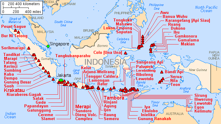
    And flores i laying on top of the fault line, which is so active that it is dotted with hundreds of active volcanoes:

    Map_indonesia_volcanoes.gif

    http://en.wikipedia.org/wiki/Geography_of_Indonesia

    In terms of Plate tectonic setting the Indonesian archipelago is situated in the triple junction of the three major plates, they are the Indo-Australian, the Eurasian and the Pacific Plates (Figure 2). The interaction of the three major plates creates a complex tectonic especially in the plate boundary that is situated in Eastern Indonesia. The LSI is mainly form as a result of the subduction of the Indo-Australian plate beneath the Sunda-Banda Arc during the upper Tertiary in which this subduction formed the inner volcanic arc of the LSI. However, there are differences in relation to the chemical analyses among the volcanic rocks in the LSI. The volcanic arc in the east Sunda region, which rests directly on oceanic crust and is bounded by ocean crust on both sides, has lavas with chemical characteristics that distinguish them from lavas in the western parts of the arc (Barber et al 1981). Hamilton (1979) suggested the inner ridge is formed of upper Cenozoic calc-alkalic rocks.
    The volcanic rocks in the inner Banda Arc of the LSI in which the oldest known rocks are Early Miocene are found about 150 Km above the inclined zone of earthquake (Hamilton 1979, Audley-Charles 1981). The very active Benioff Zone was contoured by Hatherton and Dickinson (1989) and updated by Hamilton (1978) (Figure 3). Seismicity in the Java Sector extends to a maximum depth of about 600 Km. This indicates subduction of sub-ocean lithosphere belonging to the Australian/New Guinea Plate below the Banda Arc, and the cessation of volcanism in the Early Pliocene opposite Timor suggests collision of Timor with Alor and Wetar, after all the oceanic lithosphere had been consumed by subduction.
    The size of the islands of this volcanic chain gradually is getting smaller eastward from Java through Bali, Lombok, Sumbawa, Flores, Wetar to Banda. This decreasing, which is most noticeable east of Wetar, may reflect the amount of ocean floor subducted, implying either that dip-slip motions have been more important westwards from Wetar and strike-slip motions increasingly important eastwards. Alternatively, it may be that the present volcanic arc east of Wetar is younger and perhaps that the original volcanic arc east of Wetar has been overridden by the Australian continental margin (Bowin et al. 1980)

    http://en.wikibooks.org/wiki/The_Geology_of_Indonesia/The_lesser_Sunda_Islands

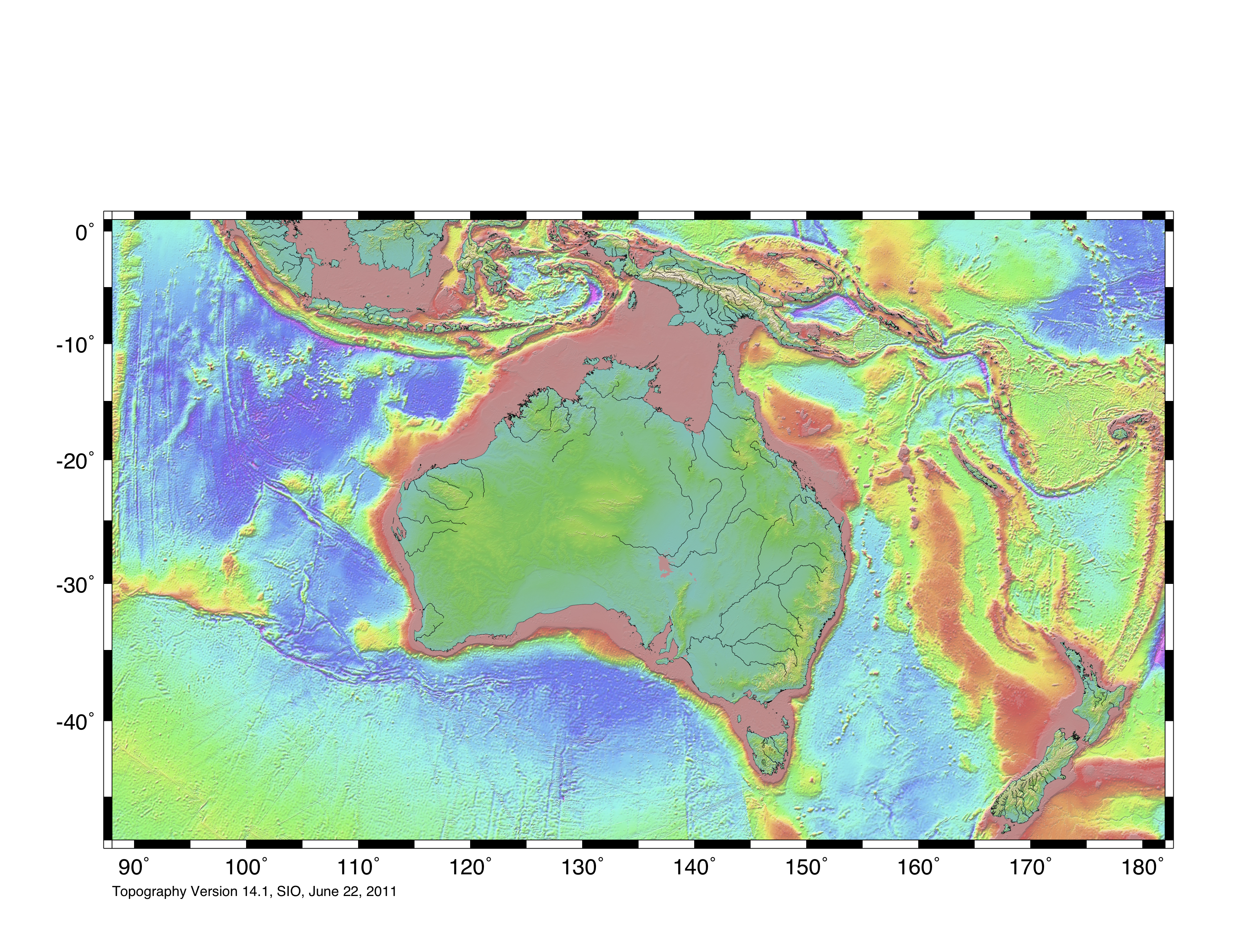
    This is topography map of the region:

    topo10.jpg

    you can see that there flores is sitting on a land ridge. The separate island were probably connected in the past with land bridge... Even though you can read this:
    Nusa Tenggara Nusa Tenggara in old Javanese means southeastern islands, refering to the tightly-packed necklace of sparsely inhabited islands stretching east from Bali. West Nusa Tenggara comprising Lombok and Sumbawa, while East Nusa Tenggara comprises Sumba, Flores, Timor and adjacent islands. The islands of Nusa Tenggara are formed by protruding peaks of a giant submarine mountain range that runs from Sumatra to Timor. The depth of water separating the islands of Nusa Tenggara is such that even at the height of Ice Ace, when the sea level was about 200 m lower, there were no land bridges between the islands.

    The archipelago is devided into three groups. The islands of Java, Sumatra, and Kalimantan, and the small islands in-between, lie on the Sunda Shelf which begin on the coasts of Malaysia and Indo China, where the sea depth does not exceed 700 feet. Irian Jaya which is part of the island of New Guinea, and the Aru Islands lie on the Sahul Shelf, which stretches north wards from the Australia coast. Here the sea depth is similar to that of the Sunda Shelf.

    Located between these two shelves is the island group of Nusa Tenggara, Maluku and Sulawesi, where the sea depth reaches 15.000 feet. Coastal plains have been developed around the islands of Sumatra, Java, Kalimantan and Irian Jaya.

    http://www.un.int/indonesia/Indonesia/Indonesia/indoninfo.html

    So you have major super active fault line, you probably have land sinking and being pushed up all the time. You add to that seal levels 120 -200 meters lower than today...So people probably walked to flores as well.

    A major problem in swimming or rafting across the channels between Indonesian islands is that currents are flowing south north and are extremely strong. I was in that part of the world and even today local passenger boats have major problems crossing the channels. You can see the currents running like giant rivers in the sea, and anything caught in them, without a strong propulsion (sales or motor) will end up in china. We went diving and were warned everywhere about the currents. It is impossible to swim against those currents even close to the shore. So swimming and rafting across is out of question. The same goes for crossing from north Africa to Crete. Just remember all the poor people that die every year trying to cross from Africa to Europe in proper boats, after their boats sink in bad seas. Imagine trying to do the same in a raft, without means of propulsion? Pueblo said, they just paddled...With what? Hands and legs? You need oars and for oars you need planks and for planks you need hafted axes...

    And this is how people walked to Australia:
    The Arafura Sea lies west of the Pacific Ocean overlying the continental shelf between Australia and Indonesian New Guinea. The Arafura Sea is bordered by Torres Strait and through that the Coral Sea to the east, the Gulf of Carpentaria to the south, the Timor Sea to the west and the Banda and Ceram seas to the northwest. It is 1,290 kilometres (800 mi) long and 560 kilometres (350 mi) wide. The depth of the sea is primarily 50–80 metres (165–265 feet) with the depth increasing to the west. As a shallow tropical sea, its waters are a breeding ground for tropical cyclones.[citation needed]

    http://en.wikipedia.org/wiki/Arafura_Sea


  • Registered Users Posts: 310 ✭✭dublinviking


    install google earth. go to indonesia. focus on channels between the islands. you can see sea depth in the status bar.


  • Registered Users Posts: 1,752 ✭✭✭markesmith


    Again, what does this have to do with Palaeolithic Ireland? Couldn't one literally walk from Brittany to the south of Ireland?

    These are fascinating posts, DV, but I fail to see the relevance...


  • Moderators, Science, Health & Environment Moderators, Society & Culture Moderators Posts: 60,075 Mod ✭✭✭✭Wibbs


    The latest discoveries in Georgia have made the whole current paleontology obsolete. There never was Erectus, they were all just humans.
    Eh no it hasn't. What is has done is widen the definition of Erectus. That skulls from elsewhere of the same time period with slightly different morphology and given new species names on the back of that are likely very wrong. That they were all basically Erectus. Erectus are the 1.0 of humans really. From them came Neandertals, Denisovans(a couple of other people) and ultimately us.
    Maybe humans existed in Flores and Andaman millions of years ago? Just thought it could be a possibility.
    And evolved into fully modern humans in isolation? I have some sympathy for the multiregional idea in very broad strokes, but no, there is practically zero possibility of that. Andaman folks are basically Africans from 20-60,000 years BP, one of the early out of Africa dudes.
    I wouldn't also exclude a drastic altering of landscape in last few hundred thousand years. Earthquakes can sink whole coast and create deep channels. So we should not exclude these as possibilities.
    Certainly, but in the areas involved oceanographers and geologists have pretty much excluded such.

    as for flores dwarfs have a look at this:


    http://en.wikipedia.org/wiki/Laron_syndrome

    Not a different species, just an epigenetic mutation. Here are dwarf people from south america:
    The Flores hominids are not dwarf moderns. They are very different in skeletal morphology. They may not even be dwarf Erectus(which asks even more questions). They're that primitive. If anything some features look more like more advanced australopithecines. Their wrists and knees are nothing like within any range of Sapiens. That's just below the neck. The skulls have features that simply can't be explained away by genetic pathology.

    Take your example. Those south American folks are indeed very small and look different to the average. However they are clearly without doubt modern humans. High cranial vault, flat of face, possession of chins. The Flores skulls are very different. I've read the paper where they're suggesting that the hobbits have Laron syndrome and I truly dunno where they bought their spectacles. Should have gone to specsavers IMHO.

    Rejoice in the awareness of feeling stupid, for that’s how you end up learning new things. If you’re not aware you’re stupid, you probably are.


  • Registered Users Posts: 310 ✭✭dublinviking


    One thing just occurred to me. One reason why we are not finding paleolithic stones in Ireland could be also the fact that many were probably reused by later people. If you are neolithic guy and you want to make a stone tool, you would have to find a pebble, break it and knap it until you get what ever tool you are making. If you see an already broken piece of flint you will normally pick it up and use it to make what ever you wanted to make. The only paleolithic stones we are finding are the ones neolithic people missed...Maybe we should examine some of the neolithic tools found in Ireland and use cosmogenic isotopes or tephrochronology to see if they have been cut earlier then their shape would suggest.

    But both of these methods have problems. In tephrochronology, layers of volcanic ash, tephra, often contain potassium-bearing minerals whose crystallization age can be determined, even going back billions of years. But the infrequency of volcanic eruptions may make it hard to date intervening sediments. But considering nearness of Iceland and frequency of volcanic eruptions there, this could be quite good enough for dating Irish artifacts. These sediments, however, are likely to contain traces of iron-bearing minerals like magnetite, which act like compasses. Their magnetic orientation is preserved when they are encased, and there has been a well-dated series of reversals of the earth’s magnetic polarity. Measuring polarity however tells us the polarity from the moment the rock was exposed to the air, not when it was used to make a tool. So different sides of the rock can give you different measurements. But it is still worth trying...


    What do you think wibbs?


    marksmith
    Again, what does this have to do with Palaeolithic Ireland?

    We are discussing ability of prehistoric humans to cross water barriers before 10,000 bc. I am saying that they could not have been able to do it. And wibbs thinks they could have and has given andaman and flores people as a proof that people were able to cross sea earlier than 10,000 bc. I was just showing that they probably didn't need to do that and that they probably walked from malay peninsula, via andaman, to flores. If you don' see how this is relevant to Paleolithic Ireland....
    Couldn't one literally walk from Brittany to the south of Ireland?

    Well i don't know. Some papers, like the one i quoted earlier say that there was no land bridge after 16,000 bc. Was there a land bridge earlier? Probably. On and off. If you look at google earth, the sea dept between Ireland and France is nowhere more than 150 meters and mostly is a lot less than 100 meters. So Ireland was probably completely connected with Europe for very long periods of time. And Very cold during the same periods of time. For humans it would have been a lot better to live in what is today sea off the southern coast of Ireland then on the actual Island of Ireland covered in Glaciers.

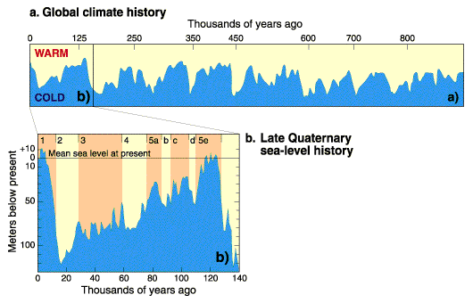
    If you look at this diagram showing sea level variation in last 150,000 years, you will see that after 25,000 bc sea level was only rising.

    1_nature11593RapidCoupling.gif

    Who ever was i Ireland at the time, and didn't escape on time, probably froze to death. But people are smarter than that and probably just wandered southward into France in the autumn, and didn't come back next spring because the land bridge was gone...

    wibbs

    me:
    The latest discoveries in Georgia have made the whole current paleontology obsolete. I mean all the different human species turn out to be just different shapes of the same species, like we have today.

    you:
    Eh no it hasn't. What is has done is widen the definition of Erectus....That they were all basically Erectus.

    Isn't this the same? There was no evolution from species to species, just one species for millions of years...
    And evolved into fully modern humans in isolation?

    This is not what i meant. What i meant is that maybe there was another much earlier migration, maybe 1 million years ago, maybe even earlier. The landscape probably looked a lot different then. Who knows what the sea levels were then. If we have Erectus, from 1,2 million years ago to today...Humans were humans then. Didn't evolve since very much. This changes things a bit don't you think?
    Certainly, but in the areas involved oceanographers and geologists have pretty much excluded such.

    I gave you data for andaman islands. You tell me if you see any problem with the possibility that the whole indonesian archipelago was connected to the mainland. I can't see the problem, i checked the ocean depths....Maybe i am missing something...
    The Flores hominids are not dwarf moderns. They are very different in skeletal morphology. They may not even be dwarf Erectus(which asks even more questions). They're that primitive. If anything some features look more like more advanced australopithecines.

    It is quite possible that we did have multiple centers of early humans, and overlapping species. And it is also quite possible that they overlapped in Indonesia. But it is also quite possible that we are talking about another human mutation. Who knows. And it is not relevant really to the story of human ability to make sea going vessels before 10,000 bc


  • Advertisement
  • Moderators, Science, Health & Environment Moderators, Society & Culture Moderators Posts: 60,075 Mod ✭✭✭✭Wibbs


    One thing just occurred to me. One reason why we are not finding paleolithic stones in Ireland could be also the fact that many were probably reused by later people. If you are neolithic guy and you want to make a stone tool, you would have to find a pebble, break it and knap it until you get what ever tool you are making. If you see an already broken piece of flint you will normally pick it up and use it to make what ever you wanted to make. The only paleolithic stones we are finding are the ones neolithic people missed...Maybe we should examine some of the neolithic tools found in Ireland and use cosmogenic isotopes or tephrochronology to see if they have been cut earlier then their shape would suggest.
    That kind of reuse is pretty easy to spot in general. Nothing much advanced beyond the mark 1 human eyeball and some knowledge of lithics. For a get go, you'd spot a clear change in patina in the flint. How humans have processed stone has changed in (fairly)notable stages. So if a modern reused say a Neandertal scraper it would be very easy to see. I dunno, like finding a 19th century made steam engine being driven by a 1990's nuclear reactor. A scraper on a levaillous flake, later resharpened/retouched would be as plain as the nose on your face(I think I"ve a french example somewhere). Even so where peoples have overlapped it's rare enough to find lithic reuse. Very small percentage of tools found.
    Isn't this the same? There was no evolution from species to species, just one species for millions of years...
    Erectus was around for about the most amount of time of any hominid, but even within that time there was evolution. The fact that they evolved into Neandertals and Denisovans and Sapiens in different environments show this.


    This is not what i meant. What i meant is that maybe there was another much earlier migration, maybe 1 million years ago, maybe even earlier. The landscape probably looked a lot different then. Who knows what the sea levels were then. If we have Erectus, from 1,2 million years ago to today...Humans were humans then. Didn't evolve since very much. This changes things a bit don't you think?
    Nope. That's not how human evolution worked. One million years ago we had erectus, a separate species to modern humans and very different in habit and morphology. The gulf between erectus and an Andaman islander and any other modern human today is vast. They were not the same species. If you met an Erectus you'd be looking into the eyes of someone on the way to becoming human, but there would be much of the "animal" behind those eyes. For your theory to work, erectus would have to evolve into a different species, modern human in a tiny area, while all the other erectus' around the world also evolved locally into moderns, while somehow keeping constant genetic contact so we're all(very) related today. Even the most ardent multiregionalist would foam at the mouth at such an idea TL;DR? Eh nope, sorry.

    But it is also quite possible that we are talking about another human mutation. Who knows.
    In the sense of a set of mutations over time that led to a subspecies of archaic hominid, not a pathological mutation like you suggested.
    And it is not relevant really to the story of human ability to make sea going vessels before 10,000 bc
    Well clearly it is. There are quite the few examples of archaic peoples getting to places that required a trip across open water before 10,000 bc. They got there somehow.

    Rejoice in the awareness of feeling stupid, for that’s how you end up learning new things. If you’re not aware you’re stupid, you probably are.


Advertisement