Advertisement
If you have a new account but are having problems posting or verifying your account, please email us on hello@boards.ie for help. Thanks :)
Hello all! Please ensure that you are posting a new thread or question in the appropriate forum. The Feedback forum is overwhelmed with questions that are having to be moved elsewhere. If you need help to verify your account contact hello@boards.ie

The Great Storm of 1171 or 1172

Options
  • 24-05-2012 1:41pm
    #1
    Moderators, Science, Health & Environment Moderators Posts: 5,219 Mod ✭✭✭✭


    Here is an interesting account of a great storm around 1172/3 which revealed axe cut trunks on the Welsh shoreline.
    The account is a translation after Giraldus Cambrensis (c.1146 - 1223) in English History from Contemporary Writers. Strongbow's conquest of Ireland. Francis Pierrepoint Barnard. 1888
    A.D. 1171 or 1172.-Of the storms.
    Girald. Cambr. Expug. Hibern. Lib. I. cap. xxxvi.
    Then were the barriers of the storm- winds burst
    and the bowels of the sea uptorn; and with such force
    and for so long did the tempest's rage endure, that
    the whole drear winter through scarce a single bark
    found its way across to Ireland, nor could aught of
    news be heard from any source. Wherefore all men
    thought that the wrath of God was upon them for
    their sins.
    It was about that time that from the unusual
    violence of the weather the sand on the shores of
    South Wales was washed away and the under soil laid
    bare, and the face of the coast was revealed as it had
    been in the far distant past. Trunks of trees appeared below high-water mark, still standing, but with their
    branches broken off or lopped, and showing traces of
    the axe as if of yesterday. The soil too was quite
    black, and the wood of the dead tree-boles was of the
    hue of ebony. Wondrous the changes wrought by
    time : that where in former days tall ships could ride,
    now no ship can go ; where was a level strand, we
    see a sylvan grove ! Perchance during the flood of
    Noah, but likelier long since that, though yet in ages
    long ago, this forest was broken down by the fury of
    the sea, and by degrees destroyed or absorbed as the
    waters rose from time to time and encroached upon
    the land.*

    * One may see these ancient stumps of trees to-day in
    Swansea Bay, and in other parts of Wales. Gerald's description
    is absolutely accurate. The black soil is also still there, and
    probably represents what is left of the foliage, branches, smaller
    trees and undergrowth.
    I wonder if the submerged tree stumps north of Bray harbour are a related feature?


Comments

  • Registered Users Posts: 3,580 ✭✭✭cfuserkildare


    Hi Slowburner,

    Some-body mentioned the Bray feature a while ago on a post I had up about lost Islands and Hy-Brasil in particular.

    Still have to go and have a look at the Bray thing. But if you look at Google Maps or Earth and look in particular at Wicklow's Murragh on the west side the land looks like submergance occurring in fields that may only be 100-200 years old.

    Any opinions welcome on this as I am working on a theory relating to this very subject.

    Cheers.


  • Moderators, Science, Health & Environment Moderators Posts: 5,219 Mod ✭✭✭✭slowburner


    Erosion is certainly a problem on the East coast, is this what you mean by submergence?
    There is a thread here on the rapidly increasing erosion of Greystones' north beach.


  • Registered Users Posts: 3,580 ✭✭✭cfuserkildare


    Hi Slowburner,

    When you look at Google Maps around Murragh in Wicklow it looks as though either land level is falling or sea level has risen. The "fields" along the water front look very man-made and now seem to be submerged.

    Cheers.


  • Moderators, Science, Health & Environment Moderators Posts: 5,219 Mod ✭✭✭✭slowburner


    The Murrough is a shingle bank, so it's vulnerable to erosion and change.
    The area was highly prized for its grazing, so a stone bridge was built across Broad Lough/Leitrim river, to the Murrough to facilitate access towards the end of the C.17th. There very probably were field boundaries there, and the Murrough itself was undoubtedly very much wider in the past.
    I know very little about the formation of the Murrough, or how such a great shingle bank was thrown up to divert the natural course of the Vartry river from eastward to southward. Presumably a product of rising sea levels over the millennia, or might the bank have been thrown up in the great storm of 1171/2?

    I'm just not seeing the submerged field boundaries you mention, apart from this linear feature, immediately north of the harbour.
    I suspect it might well be a sewerage outflow.
    If anyone knows, I'd be keen to hear what this shadowy feature is.


    (Image from Google Earth 2010)
    206807.jpg


  • Registered Users Posts: 3,580 ✭✭✭cfuserkildare


    Hi Slowburner,

    My fault as I should have said Broadlough instead of the Murragh, pretty much all of the west side looks like fields which are now beginning to sink.


  • Advertisement
  • Moderators, Science, Health & Environment Moderators Posts: 5,219 Mod ✭✭✭✭slowburner


    It's been like that as far long as I can remember. It's a tidal estuary, so it's subject to tidal forces, and is recognised as an important wildlife habitat.
    Sea levels are rising in common with every else, which might be what you are seeing.


  • Registered Users Posts: 102 ✭✭Jakub25


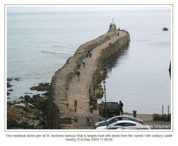
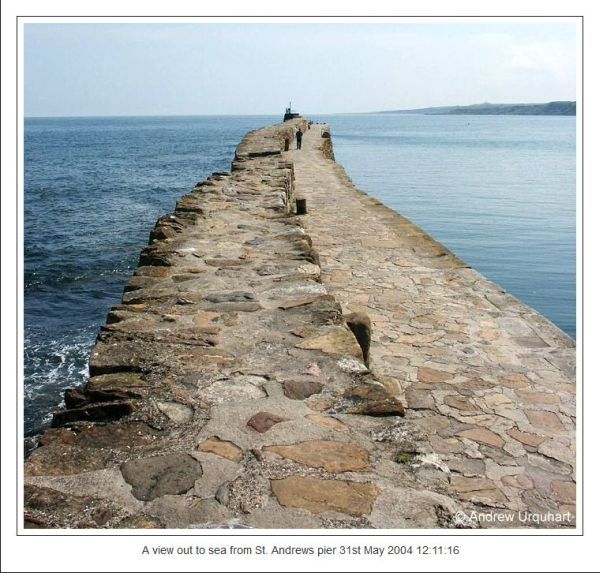
    It's look like a mark of medieval stone harbour.
    Have look at scottish one.

    scot1.jpg

    scot2.jpg


Advertisement