Advertisement
If you have a new account but are having problems posting or verifying your account, please email us on hello@boards.ie for help. Thanks :)
Hello all! Please ensure that you are posting a new thread or question in the appropriate forum. The Feedback forum is overwhelmed with questions that are having to be moved elsewhere. If you need help to verify your account contact hello@boards.ie

Hurricane KATIA

Options
124»

Comments

  • Registered Users Posts: 11,134 ✭✭✭✭maquiladora


    Sponge Bob wrote: »
    personally I think the GFS overcooks storms 7 days out. If it hits Ireland it will be a soggy event more than a windy one.

    0Z ECM also shows a powerful ex-hurricane though, and Katia is a major Cat 4 now so the potential is there. Neither models pose a threat to Ireland at the moment though. I think she will pass to our northwest but we'll see.

    Edit : 06Z GFS takes ex-Katia on a track further away from Ireland than the 0Z.


  • Registered Users Posts: 11,134 ✭✭✭✭maquiladora


    06Z GFS ensembles :

    rsbtee.gif


  • Registered Users Posts: 179 ✭✭smallwonder


    I'm due to take a youth group out surfing off the Northwest coast on Monday...should be fun:eek:


  • Closed Accounts Posts: 4,279 ✭✭✭Su Campu


    Katia's now Cat 3, 115 mph. No real change to the forecast this evening


  • Closed Accounts Posts: 4,279 ✭✭✭Su Campu


    I'm due to take a youth group out surfing off the Northwest coast on Monday...should be fun:eek:
    It'll probably be too windy for surfing won't it? Gale force on-shore winds aren't ideal. If the low stays further north and west though then there could be some nice stuff alright.


  • Advertisement
  • Registered Users Posts: 14,339 ✭✭✭✭M.T. Cranium


    The four most reliable global models have begun to converge on the expected track that we discussed ... taking the remnant low about halfway between Donegal and Iceland heading northeast towards the Shetlands or Faeroes. There is still some scatter in terms of location and intensity, the timing would appear to be late Monday and at this point I would say winds might be about as strong as today in the northwest, although not as strong elsewhere. Peak gusts from the maps I've seen on 12z runs would be 50-60 mph in exposed parts of Connacht and Donegal. I would expect some rather high tides perhaps 50 cms above normal maximum range, but not a storm surge with damage potential.

    There is still a lot of time for these outlooks to change, but that's the consensus today.

    I would put the odds on a storm force wind outcome (defined let's say as maximum wind gusts of 70 kts) at about one in four chances at this point. The odds of a complete miss further north than shown today would be about the same, meaning the odds of today's solution verifying generally speaking would be about 50-50.

    The timing uncertainty probably amounts to 18-24 hours at this point, meaning that the event could happen as early as Sunday night or as late as Tuesday morning.


  • Closed Accounts Posts: 3,548 ✭✭✭Harps


    Passing just to the north on the 12z gfs, still seems to be a 50/50 chance whether it'll give us a bit of a storm

    110912180612.gif


  • Closed Accounts Posts: 7,348 ✭✭✭the drifter


    im off to rhode island the end of the month and was checking the weather today..

    http://www.wunderground.com/US/RI/Pawtucket.html

    Friday looks interesting :P


  • Registered Users Posts: 10,508 ✭✭✭✭dsmythy


    I'm due to take a youth group out surfing off the Northwest coast on Monday...should be fun:eek:

    I'd keep a very close eye on the forecasts over the weekend before taking a youth group out.


  • Registered Users Posts: 12,778 ✭✭✭✭ninebeanrows


    There is Katia, not too far off us.

    Interesting to see where she ends up but amazing to see a real chunk of hurricane getting so close to us.

    Rtavn1141.png


  • Advertisement
  • Registered Users Posts: 179 ✭✭smallwonder


    dsmythy wrote: »
    I'd keep a very close eye on the forecasts over the weekend before taking a youth group out.

    That's why I'm slavishly following this forum;)


  • Registered Users Posts: 5,068 ✭✭✭Iancar29


    There is Katia, not too far off us.

    Interesting to see where she ends up but amazing to see a real chunk of hurricane getting so close to us.

    Rtavn1141.png

    i Cant even make out what this run has the central presssure at, what is it, 955? ? ?


  • Registered Users Posts: 10,508 ✭✭✭✭dsmythy


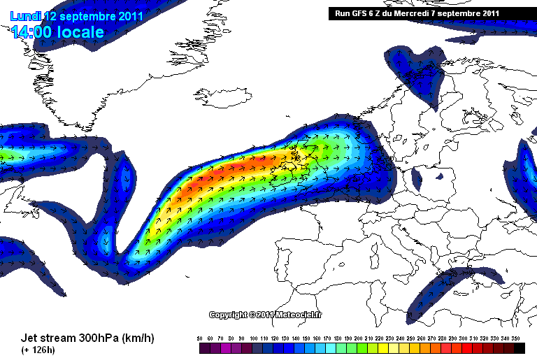
    Jetstream forecast any help for a developing system?

    jetstreamkatia.png

    Iancar29 wrote: »
    i Cant even make out what this run has the central presssure at, what is it, 955? ? ?

    Looks like 950


  • Registered Users Posts: 5,565 ✭✭✭Pangea


    What exactly would happen if the eye of the storm swept through Donegal?
    Would it be life threatening?
    At the moment it appears we are going to get the edge of the tail end of an ex hurricane which sounds very watered down but be nice if it moved closer :)


  • Moderators, Home & Garden Moderators, Science, Health & Environment Moderators Posts: 17,720 Mod ✭✭✭✭DOCARCH


    Pangea wrote: »
    What exactly would happen if the eye of the storm swept through Donegal?

    One consolation would be it would be sunny and calm in the middle! :)


  • Registered Users Posts: 14,339 ✭✭✭✭M.T. Cranium


    I've posted an update on guidance and potential on the Boards forecast thread, but here's my assessment of the latest guidance from 12z model runs. In brackets at the end of each comment, you'll find my predicted maximum wind gusts in Mayo and Donegal if the given map or verbal guidance verified exactly, with the timing of these maximum winds.

    GFS -- holding firm on a close encounter with Donegal Bay (60 kts, 09h Mon)
    ECM -- slight downgrade in terms of track, same inrtensity (55 kts, 09h Mon)
    NHC -- similar to ECM, an extension forward of previous track & intensity
    UKM -- intensifying solution relative to previous run, close (60 kts, 06h Mon)
    GEM -- has slowed its solution to give a Tuesday storm (55 kts, 12h Tues)

    The timing above would be the peak of a period of 6-9 hours of gale or storm force winds. Hurricane force wind gusts on all current guidance would be in outer Donegal Bay and beyond but only very slight changes are required to bring those much closer to land.


    On a different subject, looking at recent posts, we should be clear that the strongest winds in an extratropical storm are further from the centre than in a tropical system. The eye tends to be almost absent after transition and basically what you're dealing with, is the equivalent of a major midwinter storm that formed out of the remnants of a hurricane. On the track of Katia, the transition can be expected to take place late Saturday southeast of Newfoundland. The strongest winds will be 50-150 miles southeast of the centre as it rushes across the Atlantic. Maritime interests would already be plotting courses for ocean-going vessels that would avoid the entire circulation inside the 990 mb contour but especially 970-980 mbs, that's where you would expect the hurricane force gusts to maintain (in a 960 mb storm). This is why I have been concerned about wind damage potential on land because actually if the storm passed right over Donegal, the strongest winds would shift south and hit the southern half of Ireland, and while it's true that winds would fall off near the centre there would probably not be a calm eye or any long interval of clearing skies there at this stage.

    When Debbie rushed past Ireland on 16-09 1961, the convention back in those days was to continue the designation "hurricane" and the concept of extratropical transition was different -- so the storm is shown on historical maps as being a hurricane until about 58 deg N but in fact it probably underwent extratropical transition southwest of Ireland. Note the track of Debbie and the zone of strongest winds on land running from about Galway to Antrim, 100-200 miles east of the track of the low. Although that storm came from the Azores, the dynamics would be similar, so we need to keep Katia a good distance off the northwest coast to avoid wind damage potential, or, see a faster reduction in central pressure than most of the models have now.

    My forecasting from here to the actual event will probably follow a 3-2 weighted ratio of ECM and GFS with slight tweaking from input of other models if they don't fall close to that range. However the 12 hour forecast which should be available some time Sunday would involve a wider range of meso-scale factors that are becoming evident on radar and satellite imagery. At this distance out, we can only realistically model the storm in very general terms but closer to the event, troughs and meso-scale features will become apparent.


  • Registered Users Posts: 14,339 ✭✭✭✭M.T. Cranium


    Just briefly, some of the other guidance, NOGAPS is similar to the NHC and GFS-Euro compromise, the Russian model is similar to the UKm, and the JMA lags the storm like the GEM but also weakens it for a late Tuesday pass that would be the weakest of all depictions I've seen so far.

    Meanwhile, I have brewed up this map as a schematic for today's consensus track assuming a 960 mb low north of Malin Head as shown at 12z.

    On this map, the black line indicates track and various colour shaded regions depict zones with maximum wind gusts (forecast from modelling) above 40, 50, 60, 70 and (briefly on western edge of map) 80 knots.

    Note how the track of these higher gusts runs relative to the storm track, about 1 to 3 degrees of latitude south. Note also how each zone narrows as the storm fills up slowly. The colour hatching depicted over land is schematic and all you should take from that is within the indicated zones over land, max wind gusts would reach higher values in exposed areas only, but could be as little as 50% of the zone's depicted values for sheltered spots. All of these stronger winds would be from south through west, the reason why the zones do not extend north of the track in this case is partly for clarity but also because the northeast winds on that side of the track would probably max out in the lower category (40-50 knots) anyway.

    The modelling is based on numerous cases of similar storms over 10-15 C ocean regions east or south of Newfoundland which regularly sees extra-tropical hurricanes just after their transition has either begun or ended. Strongest winds in the populated southeast corner of Newfoundland (the Avalon Peninsula, notably St John's) occur when the centre of these storms passes through east-central Newfoundland or over the western side of the Avalon. The modelling also incorporates a few cases of similar extratropical storms closer to Ireland.

    Note that the 60 knot zone begins just about at the northwest coast in this case. If the storm shifted south and maintained intensity, these zones would all shift south in phase. If it shifted south and weakened 30%, the stronger wind zones would disappear from the forecast and it would verify over land as is. If the storm shifts north, all of these gusty winds will shift away from Ireland along with the storm.


  • Registered Users Posts: 11,134 ✭✭✭✭maquiladora


    It's not often you see Donegal making it into the Tropical Storm cone of uncertainty. :pac:

    sgr392.gif


  • Closed Accounts Posts: 6,388 ✭✭✭gbee


    Hmmm, it can't possibly be a tropical storm as the above is showing, ? And yes I've read empty head :) who puts it a sub tropical trough ~ so why this and other models ~ ** to my eyes ** still calling it a TS?


  • Registered Users Posts: 11,134 ✭✭✭✭maquiladora


    gbee wrote: »
    Hmmm, it can't possibly be a tropical storm as the above is showing, ? And yes I've read empty head :) who puts it a sub tropical trough ~ so why this and other models ~ ** to my eyes ** still calling it a TS?

    It might have tropical storm force winds but it will be an an extratropical cyclone I guess.

    The track in that map is the official NHC track.
    120H 12/1800Z 60.0N 7.0W 60 KT 70 MPH...POST-TROP/EXTRATROP


  • Advertisement
  • Registered Users Posts: 14,339 ✭✭✭✭M.T. Cranium


    The technical considerations for naming a storm "tropical" or in rare cases "sub-tropical" include having a warm core (no fronts spiralling out of the centre as with normal lows), and an eye feature with an eyewall (not just a calm centre, but a strong wind gradient also).

    The convention is more or less to assume extra-tropical transition will begin when the storm leaves ocean regions having surface temperatures below 23 C and will be complete within 6-9 hours.

    Every case is somewhat different and the main point for the public or those who receive weather forecasts is to predict accurately the wind speeds of whatever kind of storm it is, so apparently the Weather Underground folks decided to minimize confusion of presentation by keeping hurricane and tropical storm symbols on the map to indicate that's how strong the winds would be in those locations (if the forecast verifies).

    But it does not mean that a hurricane is predicted west of Ireland on Sunday or a tropical storm north of Ireland on Monday. It just means that winds that strong are predicted with an extratropical storm. The effects would be the same, but the pattern relative to the storm system tends to expand and move more to the forward side of the storm after extratropical transition.

    If you drove on the right, this analogy would work (it was developed for readers in North America). You're on the side of the highway for some reason watching a distant large vehicle approaching. You think, "it's going to miss me, I'm not in its path." But then the vehicle suddenly doubles in width and speeds up in its forward speed, although for some reason, it loses half its load. How do you assess your situation now? "It's going to hit me, but with half the force of the original vehicle."

    But as ye drive on the left, this may cause a bit of confusion visualizing the image (the highway is the storm track).


  • Registered Users Posts: 5,963 ✭✭✭TheMilkyPirate


    Just briefly, some of the other guidance, NOGAPS is similar to the NHC and GFS-Euro compromise, the Russian model is similar to the UKm, and the JMA lags the storm like the GEM but also weakens it for a late Tuesday pass that would be the weakest of all depictions I've seen so far.

    Meanwhile, I have brewed up this map as a schematic for today's consensus track assuming a 960 mb low north of Malin Head as shown at 12z.

    On this map, the black line indicates track and various colour shaded regions depict zones with maximum wind gusts (forecast from modelling) above 40, 50, 60, 70 and (briefly on western edge of map) 80 knots.

    Note how the track of these higher gusts runs relative to the storm track, about 1 to 3 degrees of latitude south. Note also how each zone narrows as the storm fills up slowly. The colour hatching depicted over land is schematic and all you should take from that is within the indicated zones over land, max wind gusts would reach higher values in exposed areas only, but could be as little as 50% of the zone's depicted values for sheltered spots. All of these stronger winds would be from south through west, the reason why the zones do not extend north of the track in this case is partly for clarity but also because the northeast winds on that side of the track would probably max out in the lower category (40-50 knots) anyway.

    The modelling is based on numerous cases of similar storms over 10-15 C ocean regions east or south of Newfoundland which regularly sees extra-tropical hurricanes just after their transition has either begun or ended. Strongest winds in the populated southeast corner of Newfoundland (the Avalon Peninsula, notably St John's) occur when the centre of these storms passes through east-central Newfoundland or over the western side of the Avalon. The modelling also incorporates a few cases of similar extratropical storms closer to Ireland.

    Note that the 60 knot zone begins just about at the northwest coast in this case. If the storm shifted south and maintained intensity, these zones would all shift south in phase. If it shifted south and weakened 30%, the stronger wind zones would disappear from the forecast and it would verify over land as is. If the storm shifts north, all of these gusty winds will shift away from Ireland along with the storm.

    It's a good thing it was weather and not art that was your hobby MT.


  • Registered Users Posts: 5,068 ✭✭✭Iancar29


    Tenner bets >>>>

    * Weekend's Newspaper *

    "HURRICANE TO HIT THE WEST , BATTER DOWN HATCHES

    :rolleyes: :rolleyes: :rolleyes:


  • Registered Users Posts: 2,674 ✭✭✭Rougies


    Iancar29 wrote: »
    Tenner bets >>>>

    * Weekend's Newspaper *

    "HURRICANE TO HIT THE WEST , BATTER DOWN HATCHES

    :rolleyes: :rolleyes: :rolleyes:

    A plentiful free supply of battered cod would be great for the local economies of the coastal towns in the the west and northwest. Batter betten down the hatches though if Katia has her eye on us, she could easily become a lunatic, especially at that time of the month ... :|


  • Registered Users Posts: 14,339 ✭✭✭✭M.T. Cranium


    Briefly, 00z guidance seems to have a slightly more intense theme in general, but as usual, with some variations:

    ECM -- apparently holding steady with potential for storm force gusts in n.w.

    GFS -- a slightly stronger depiction that raises the possibility of somewhat more widespread gales and storm force gusts

    GEM -- back to earlier projections, has abandoned the Tuesday visit now, similar to GFS in timing and somewhat more intense than any other solution seen to date -- would give 80 knot wind gusts for Donegal. (960 mb low at 57N 10W 12z Monday). This one concerns me because of the phasing with a deep upper vortex and strong jet stream winds over southern Ireland. This solution, if it proves correct, would cause the forecast to be upgraded for all regions.

    UKMO -- Seems to have lost the plot again, as with previous 00z ... some sort of initialization problem, possibly? There is almost no sign of Katia on the Sunday panel.

    NHC -- their track continues similar to before, if anything, it edges slightly closer to Ireland. Worth noting that the hurricane has stopped weakening as of 06z and was reported slightly stronger. Awaiting the 09z updates with interest.

    NOGAPS -- Strong also, but trending a bit north.

    Given the blend of the above, I am maintaining my previous day's forecast wind values. It should be noted that the storm will rush in behind a fairly strong frontal system and winds will already be moderate by mid-day Sunday, then may begin to ramp up to stormy values late Sunday evening, peaking Monday morning on current indications.

    A further nudge south would probably change the forecast to suggest strong winds in most regions and widespread squally showers, but on the present track, there should be a fairly distinct northwest to southeast gradient in severity of the storm.


  • Registered Users Posts: 14,339 ✭✭✭✭M.T. Cranium


    I have the feeling that reader interest will swing from this thread to the "Monday threat" thread so I plan to post forecast discussions related to Ireland in that thread from now on.

    Katia came very close to ocean buoy 41044 last night and at one point around 06-07z the buoy was in the eastern eyewall and reporting wind gusts to 93 knots or 107 mph.

    Katia seems to have regained a bit of strength in the past 18 hours and looks to be heading slightly east of due north near 70 W, about to be swept into the fast flow extending from south of Nova Scotia to north of Ireland.

    The NHC gives a Monday 12z position at 59.5N 10W on its latest outlook which would place the strongest winds around 57N 8W but the GFS has the centre just about in that position which would place the strongest winds over Donegal. Since the GFS depiction may be slightly weaker than the NHC's implied map intensity (from their maximum winds) I would estimate the GFS 12z charts to be predicting sustained winds near 55 mph and gusts near 80 mph or 70 knots from 0600 to 0900 Monday. A storm as strong as the NHC forecast in the GFS position would give sustained 60 mph, gusts 90 mph or near 80 knots.

    Will be making more extensive model comparisons later on the "Monday threat" thread.


Advertisement