Advertisement
If you have a new account but are having problems posting or verifying your account, please email us on hello@boards.ie for help. Thanks :)
Hello all! Please ensure that you are posting a new thread or question in the appropriate forum. The Feedback forum is overwhelmed with questions that are having to be moved elsewhere. If you need help to verify your account contact hello@boards.ie
Hi there,
There is an issue with role permissions that is being worked on at the moment.
If you are having trouble with access or permissions on regional forums please post here to get access: https://www.boards.ie/discussion/2058365403/you-do-not-have-permission-for-that#latest

Google Street View now available for Republic of Ireland!

  • 16-06-2010 10:16am
    #1
    Registered Users, Registered Users 2 Posts: 385 ✭✭


    Just saw the little orange man staying orange over Dublin in Google Maps. I dragged him out and sure enough, Google seems to have activated random spots around the country for Street View. Very sporadic, seems to be only one photo every 10 kms or so.

    Are they testing it, preparing for a full launch or is it all just a mistake? Who knows, Google move in mysterious ways!

    p.s. Couldn't look at the imagery myself as I don't have Flash 9 on my work PC so not even sure it works.....


«1

Comments

  • Registered Users, Registered Users 2 Posts: 8,642 ✭✭✭cml387


    Nope,they are photos submitted by the public.Anyone can do it.


  • Closed Accounts Posts: 3,942 ✭✭✭Danbo!


    Unfortunately its just geo-tagged images from the web from joe public, rather than street view cars.


  • Banned (with Prison Access) Posts: 25,234 ✭✭✭✭Sponge Bob


    Not streetview, they are geocoded snapshots scraped from various photo sites. Well spotted though :)


  • Closed Accounts Posts: 3,032 ✭✭✭DWCommuter


    Why havent they introduced street view in Ireland? They had enough cameras out working last year.


  • Registered Users, Registered Users 2 Posts: 3,284 ✭✭✭dubhthach


    DWCommuter wrote: »
    Why havent they introduced street view in Ireland? They had enough cameras out working last year.

    Maybe they deleted the photos along with the wireless data they collected illegally ;)


  • Advertisement
  • Registered Users, Registered Users 2 Posts: 9,160 ✭✭✭SeanW


    Huh?

    BTW I was very bored one night so I tested out Google Street View at the Irish/NI border. You can see into the Republic from a number of border crossing, and I think that the Google SV vans actually started taking snaps in the republic as well, albeit only a few meters on the Irish side.


  • Registered Users, Registered Users 2 Posts: 1,450 ✭✭✭actuallylike


    SeanW wrote: »
    Huh?

    BTW I was very bored one night so I tested out Google Street View at the Irish/NI border. You can see into the Republic from a number of border crossing, and I think that the Google SV vans actually started taking snaps in the republic as well, albeit only a few meters on the Irish side.
    They've already mapped a lot of the republic, the vans were seen driving around well over a year ago. They just haven't uploaded them yet.
    I hope the inflatable penis I had in my window shows up! (It was there for street view...honestly :o)


  • Registered Users, Registered Users 2 Posts: 9,487 ✭✭✭banquo


    Dying to play around with this. Get on it, google!


  • Closed Accounts Posts: 454 ✭✭irishdub14


    Looks like we'll have street view next week!

    http://google-latlong.blogspot.com/


  • Banned (with Prison Access) Posts: 25,234 ✭✭✭✭Sponge Bob


    which bit of "driving" needs explaining ????

    Dublin Dublin South West
    Donegal Letterkenny, Buncrana, Derrybeg, Donegal Town, Ballyshannon
    Sligo Cliffoney, Sligo
    Leitrim Ballinagrelah
    Cavan Cavan West
    Louth Dundalk
    Monaghan Carrickmacross
    Kildare Newbridge
    Wicklow Stratford on Slaney
    Kerry Killarney
    Limerick Limerick West
    To find out more about where we're driving get in touch or learn more about how Street View works and how we protect privacy you can do so here: streetview-europe@google.com


  • Advertisement
  • Closed Accounts Posts: 3,942 ✭✭✭Danbo!


    irishdub14 wrote: »
    Looks like we'll have street view next week!

    http://google-latlong.blogspot.com/

    Looks more like we'll have the cars on the the streets again next week, rather than streetview being available. Damn.


  • Registered Users, Registered Users 2 Posts: 8,913 ✭✭✭Danno


    According to an article in today's indo, it will all be up by the end of 2010 after google satisfied the authorities over wifi data gatering.


  • Closed Accounts Posts: 49 John Lynch Ph.D


    In May we announced that we had mistakenly included code in our software in Street View cars that collected WiFi payload data.

    Haha, no mistake, in case it wasn't obvious enough. I know for a fact it was actually the primary purpose, payload is the actual data been sent, so as you can imagine collecting this would be a far greater exercise then simply collecting data about wifi locations, not something you do by mistake.

    It is the PRIMARY reason for google street view. the pictures are just an excuse.


  • Registered Users, Registered Users 2 Posts: 549 ✭✭✭unit 1


    Haha, no mistake, in case it wasn't obvious enough. I know for a fact it was actually the primary purpose, payload is the actual data been sent, so as you can imagine collecting this would be a far greater exercise then simply collecting data about wifi locations, not something you do by mistake.

    It is the PRIMARY reason for google street view. the pictures are just an excuse.

    I'm a bit stretched understanding some of this new technology, could you expand a bit on your theory, and does it fall into the "if you are doing nothing wrong you have nothing to worry about category", or is there a corporate greed for data basis to it.


  • Closed Accounts Posts: 49 John Lynch Ph.D


    unit 1 wrote: »
    I'm a bit stretched understanding some of this new technology, could you expand a bit on your theory, and does it fall into the "if you are doing nothing wrong you have nothing to worry about category", or is there a corporate greed for data basis to it.

    Dont worry even if you are doing 'something' wrong you've nothing to worry about, mostly for advertising and commercial uses, the specifics of which I am unaware.

    It's all about money and business and nothing to do with government, which is fine mostly by me actually.


  • Registered Users, Registered Users 2 Posts: 7,544 ✭✭✭Hogzy


    What do you mean by collecting wifi packet data?


  • Closed Accounts Posts: 7,973 ✭✭✭RayM


    Haha, no mistake, in case it wasn't obvious enough. I know for a fact it was actually the primary purpose, payload is the actual data been sent, so as you can imagine collecting this would be a far greater exercise then simply collecting data about wifi locations, not something you do by mistake.

    It is the PRIMARY reason for google street view. the pictures are just an excuse.

    I don't have any letters after my username, so I could be completely wrong (and, as this is Google we're talking about, very naïve too), but I strongly doubt that collating people's wifi data is the primary purpose of Street View. If that were the case, I don't think they would have bothered covering thousands of miles of the Australian outback, for instance. If they simply wanted to snatch people's personal information, there are more logistically simple (and less conspicuous) methods of doing so than driving around in a fleet of Google-branded cars, with huge tripods on their roofs.


  • Registered Users, Registered Users 2 Posts: 549 ✭✭✭unit 1


    Maybe they are hiding in full "street"view.


  • Registered Users, Registered Users 2 Posts: 3,284 ✭✭✭dubhthach


    Hogzy wrote: »
    What do you mean by collecting wifi packet data?

    As well as taking photos they partook in abit of war-driving. Taking a gps record for every wireless network they detected on route. Normally this wouldn't be too much of an issue if it was a case of just mapping access point position. However it would seem that they actually accessed unencrypted networks and record some of the network traffic on them.

    this cause a major issue with several govs around Europe. In case of Ireland they had to destroy all the Wifi data they had collected while mapping Irish roads.


  • Registered Users, Registered Users 2 Posts: 7,544 ✭✭✭Hogzy


    So what use would such wifi data be to Google?


  • Advertisement
  • Registered Users, Registered Users 2 Posts: 3,284 ✭✭✭dubhthach


    Hogzy wrote: »
    So what use would such wifi data be to Google?

    Well technically it would help with applications such as A-GPS on Android phones. If you have a massive database of the location of WiFi access points then you can use them to triangulate the phones position. After all the phone has built in wifi to detect the AP's.

    The amount of Access Points out there is amazing tbh. I mapped about 10k of them when I moved to Dublin in 2007. On average I was picking one up every 5metres while driving around.


  • Registered Users, Registered Users 2 Posts: 14,015 ✭✭✭✭Mc Love


    Launches today folks:

    http://www.siliconrepublic.com/comms/item/18002-google-to-launch-street/
    Google’s ingenious, yet controversial, Street View component of Google Maps is due to go live in Ireland today after Google cars and Google trikes conducted intensive mapping of Dublin, Cork, Limerick, Galway and Waterford.

    Street View is a service on Google Maps that gives users the option of exploring a street or historical site at street level and take in panoramic views of that setting.

    The service is expected to be launched at Google's Dublin headquarters later this morning by Tourism Minister Mary Hanafin TD.

    Google cars arrived in Dublin earlier this year with the aim of mapping out city centres plus suburban and outlying areas.

    Last month, Google stepped up this activity by putting an 18-stone vehicle called the Trike on Irish streets that allowed the Google cameras to go where cars don’t.

    The Trike was able to collect street-level imagery of some of Ireland’s top tourist destinations and historic monuments.

    The new Aviva Stadium and Dublin Zoo were among the first locations to be filmed by the Google Trike. Other locations confirmed to be cycled by the Google Trike are The Botanical Gardens, Phoenix Park, St Stephen's Green, Dublin Castle, the Garden of Remembrance, Rathfarnham Castle, The Iveagh Gardens, War Memorial Gardens and Fota Wildlife Park. Locations will be updated online.
    Controversy

    However, the Street View service became mired in controversy earlier this year when it emerged the Street View technology in Google cars were intercepting private Wi-Fi data. The equipment apparently had “mistakenly” contained code that caused it to gather Wi-Fi data.

    And while countries like Germany, France and Spain have asked Google to hand over Wi-Fi data that was intercepted by Google’s Street View teams, Ireland’s Data Protection Commission told the search giant to destroy the data.

    “We just told them to delete it,” a spokesman for the Data Protection Commission told Siliconrepublic at the time. “Our normal response to improper data is to delete it on the spot, Germany took a different take.”

    “When they reported this, we told them to delete it and get the deletion verified by a third party, which they did.

    “They have given us an assurance that they won’t do it again,” the spokesman said at the time.


  • Registered Users, Registered Users 2 Posts: 14,015 ✭✭✭✭Mc Love


    Goes live tomorrow evening


  • Registered Users, Registered Users 2 Posts: 1,358 ✭✭✭jimbis


    Mc Love wrote: »
    Goes live tomorrow evening

    Are they having problems with it?


  • Registered Users, Registered Users 2 Posts: 14,015 ✭✭✭✭Mc Love


    Not that I can see:

    http://www.siliconrepublic.com/comms/item/18018-street-view-to-go-live-at/
    Google has officially launched Street View on Google Maps. However, eager users will have to wait until Friday evening (1 October) for the application to be fully live.

    The application, which gives users a panoramic view of a location from street level, will go live at maps.google.ie tomorrow night.

    Chambers Ireland, Daft Media, Failte Ireland and the Arts Council have partnered with Google to fully integrate Street View into their respective websites to illustrate properties, businesses, cultural events and top tourist destinations.

    Street View is a feature of Google Maps and Google Earth. Users can zoom in to the lowest level on Google Maps, or by dragging the orange ‘Pegman’ – Street View’s mascot – icon on the left-hand side of the map onto a blue highlighted street.

    Users will be able to check out a restaurant before arriving, make travel plans, arrange meeting points, get a helping hand with geography homework, or just explore and get to know a town better.

    “Street View has been hugely popular with our users in Europe and worldwide and we're thrilled it's now available in Ireland, enabling users to see street-level panoramas of major city roads and to look up and print out useful driving directions,” said John Herlihy, VP, Global Ad Operations and head of Google in Ireland.

    “Google Maps and Google Earth have long been popular with Irish people and are used by governments, businesses and individuals as essential and informative tools every day of the week - Street View now adds a new dimension.

    “One of the really exciting applications for Street View is in the education field. Teachers can incorporate Street View, Google Maps and Google Earth into geography or history lessons or arrange a virtual field trip. This is a really practical application of technology in the classroom which benefits students,” he added.

    Herlihy said Google has gone to great lengths to safeguard privacy. Any user can easily flag images for removal that he or she considers inappropriate by clicking on ‘report a problem’. Street View also features technology that automatically blurs both faces and licence plates.

    “Our technology is very effective though it may occasionally miss a face or number plate here and there. If users spot something our technology has missed just press ‘report a problem’ and we’ll get it fixed quickly,” Herlihy added.
    Privacy

    Street View has been used for some imaginative purposes, including one Google employee who proposed to his girlfriend via Street View. Police in the US used Street View to find the location of a kidnapped child.

    Despite a controversy over privacy which flared up when Google’s Street View cars unintentionally gathered up Wi-Fi data from homes, the deputy Data Protection Commissioner of Ireland Gary Davis said he was satisfied privacy is tantamount.

    “We worked closely with Google to ensure that any privacy concerns that people might have were addressed in advance of the launch date. Inevitably, some images of people were captured as the camera-cars were driven on Irish streets.

    “Google has undertaken to blur the faces of such people, as well as car number plates. This should eliminate most privacy concerns. Where blurring is insufficient or where people wish to remove other information associated with them - including images of their houses - Google has provided an easy-to-use removal tool,” Davis said.


  • Banned (with Prison Access) Posts: 25,234 ✭✭✭✭Sponge Bob


    Now Live. They have not updated their utterly crap maps using their own GPS traces and the results are, shall we say, confusing :)


  • Closed Accounts Posts: 6,093 ✭✭✭Amtmann


    It. is. magnificent!


  • Registered Users, Registered Users 2 Posts: 769 ✭✭✭Jayuu


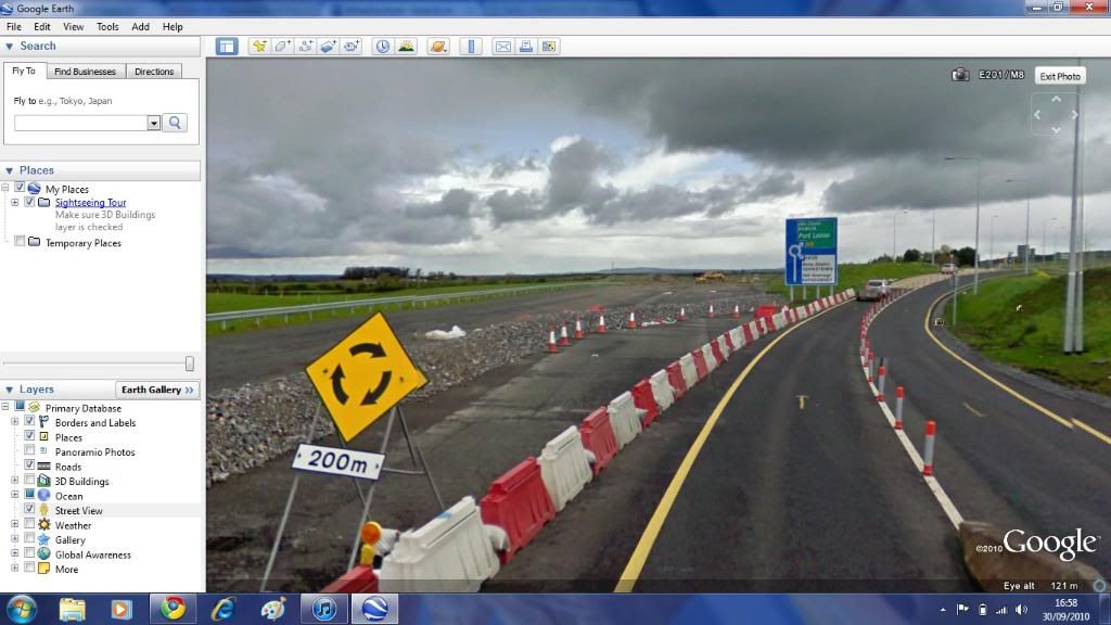
    This is a huge problem with GoogleMaps and StreetView. Because most of the photographing took place last year they obviously now can't update their maps with the new motorway system because StreetView won't work on it. It seems like they've spent a lot of time and money for something that's quite out of date.

    What's more annoying is that there are probably many tourists who use GoogleMaps for planning when visiting Ireland and are left with the opinion that we have half a motorway network. The AA Ireland site also uses GoogleMaps. I was trying to plan a route for my sister some time back and ended up just writing out directions for her.

    I wonder if anybody who attended this launch asked as to when they might consider updating StreetView and GoogleMaps to reflect the reality of the Irish road network.


    As an aside, is anybody else having problem using GoogleMap with Firefox. When I load the maps it starts fine but the minute I try to move or pick up the little man for StreetView the whole thing seems to stop (and I get the "Loading" message at the top of the screen). Doesn't seem to be a problem in IE.


  • Banned (with Prison Access) Posts: 25,234 ✭✭✭✭Sponge Bob


    Works OK for me in the latest 3.6.x version of firefox. I recommend you run the latest adobe flash update in firefox to fix it including firefox plugin.

    This link works for me perfectly in both browsers, to test with.

    http://maps.google.com/?ie=UTF8&ll=53.346432,-6.263623&spn=0.000754,0.002411&z=19&layer=c&cbll=53.346535,-6.263598&panoid=1vfXWWtskIs-fCjf3Hep9A&cbp=12,87.71,,0,5


  • Advertisement
  • Registered Users, Registered Users 2 Posts: 769 ✭✭✭Jayuu


    Sponge Bob wrote: »
    Works OK for me in the latest 3.6.x version of firefox. I recommend you run the latest adobe flash update in firefox to fix it including firefox plugin.

    This link works for me perfectly in both browsers, to test with.

    http://maps.google.com/?ie=UTF8&ll=53.346432,-6.263623&spn=0.000754,0.002411&z=19&layer=c&cbll=53.346535,-6.263598&panoid=1vfXWWtskIs-fCjf3Hep9A&cbp=12,87.71,,0,5

    Cheers.
    There seems to have been some fault in my version of Firefox. Slightly worried that there might be some sort of trojan at work here. Doing a scan of my PC to make sure nothing is wrong. Anyway I removed Firefox and reloaded to a different location and all seems fine now!


  • Closed Accounts Posts: 3,032 ✭✭✭DWCommuter


    My rear reg plate is perfectly visible.


  • Registered Users, Registered Users 2 Posts: 14,015 ✭✭✭✭Mc Love


    Its brilliant, found one or two things were part of a road was missing even though the the bit before and after!

    Also saw my neighbours outside their house!

    Oh and my house!!! :D


  • Banned (with Prison Access) Posts: 25,234 ✭✭✭✭Sponge Bob


    To get to my house I must get the marker coming down the road not going up the road where it jumps straight to my neighbours.

    Shame they did not switch to using the roads they mapped themselves instead of the cacky maps they have. A proper road map ( a la yahoo maps/navtech) would really make it work smoothly.


  • Closed Accounts Posts: 6,093 ✭✭✭Amtmann


    Jayuu wrote: »
    This is a huge problem with GoogleMaps and StreetView. Because most of the photographing took place last year they obviously now can't update their maps with the new motorway system because StreetView won't work on it. It seems like they've spent a lot of time and money for something that's quite out of date.

    What's more annoying is that there are probably many tourists who use GoogleMaps for planning when visiting Ireland and are left with the opinion that we have half a motorway network. The AA Ireland site also uses GoogleMaps. I was trying to plan a route for my sister some time back and ended up just writing out directions for her.

    I wonder if anybody who attended this launch asked as to when they might consider updating StreetView and GoogleMaps to reflect the reality of the Irish road network.

    It's interesting for nostalgia purposes anyway - NOT!

    nostalgia.jpg


  • Registered Users, Registered Users 2 Posts: 1,312 ✭✭✭patrickbrophy18


    Deadly!!!!!!!!!!!!!!:D

    Pretty much, the entire capital is now virtual. Now I can take a full virtual tour around Dalkey. SSSSSSSSSSWWWWWWWWWEEEEEEETTTTTTTT!


  • Advertisement
  • Banned (with Prison Access) Posts: 25,234 ✭✭✭✭Sponge Bob


  • Closed Accounts Posts: 13,687 ✭✭✭✭jack presley


    The image of my house is around 2 years old.


  • Registered Users, Registered Users 2 Posts: 3,110 ✭✭✭KevR


    Fantastic!! I'm delighted that this has finally gone live.

    Typical that they drove past my house on bin collection day; the bins outside are an eyesore. At least the one car that was in the driveway is really clean. :)

    I passed the streetview car last year on the old N6 (now R446) somewhere between Ballinasloe and Athlone. I must try and locate myself on it someday when I'm very bored!


  • Closed Accounts Posts: 3,548 ✭✭✭Harps


    I passed it plenty of times around Letterkenny, checked a few spots but haven't found myself. Guessing they must film everything a few times and select the best quality imaging


  • Registered Users, Registered Users 2 Posts: 3,110 ✭✭✭KevR


    Going through a manned toll booth for the Port Tunnel

    It seems really dark inside the Port Tunnel; it's really a lot brighter than the streetview images suggest.


  • Advertisement
  • Moderators, Motoring & Transport Moderators Posts: 14,093 Mod ✭✭✭✭monument


    Main problem I'm having is the geo data seems messed up in a notable amount of places. When clicking along a road main roads flick to estate roads etc

    Also have found issue as mentioned above about missing images along one road, it flicks and you know you've moved too much.


  • Registered Users, Registered Users 2 Posts: 3,110 ✭✭✭KevR


    @monument, same has happened to me a few times (clicking along and it suddenly flicks onto another road).

    Anyone know if you can check the date/time of a specific streetview image?


  • Banned (with Prison Access) Posts: 25,234 ✭✭✭✭Sponge Bob


    Flicks onto roads that are not mapped but where the car has evidently been , eg Dun na Carraige in Salthill where Cement Truck man lives is in the middle of a 'dark' stretch at Blackrock. Go west from prom towards golf club


  • Posts: 31,118 ✭✭✭✭ [Deleted User]


    I "drove" down my road and the sequencing is a bit out, it went past the house before mine then one three after mine than back to mine. :confused: anyway clicked on the report errors button. I think the S bend confused the software used to stitch the lmages.

    Will be interesting to see how quickly it get resolved. I'm not expecting anything soon as they'll probably be swamped by requests to remove "incriminating" images. ;);)


  • Registered Users, Registered Users 2 Posts: 3,284 ✭✭✭dubhthach


    Their facial blurring software also blurred the politicians posters as well as billboards. Though of course you can still identify the candidates by their name/party. :D


  • Registered Users, Registered Users 2 Posts: 5,081 ✭✭✭fricatus


    dubhthach wrote: »
    Their facial blurring software also blurred the politicians posters as well as billboards. Though of course you can still identify the candidates by their name/party. :D

    Yeah, I noticed that. Tons of political posters around Waterford at any rate (and probably plenty of other places too) for the European elections.


  • Banned (with Prison Access) Posts: 25,234 ✭✭✭✭Sponge Bob


  • Registered Users, Registered Users 2 Posts: 261 ✭✭Poster King


    Saw that alright, great spot that for a bit of crazy driving, but shame they didn't go out to Omey island.
    I notice they didn't do any islands, not even Aran Islands, shame.


  • Advertisement
Advertisement