Advertisement
If you have a new account but are having problems posting or verifying your account, please email us on hello@boards.ie for help. Thanks :)
Hello all! Please ensure that you are posting a new thread or question in the appropriate forum. The Feedback forum is overwhelmed with questions that are having to be moved elsewhere. If you need help to verify your account contact hello@boards.ie
Hi all,
Vanilla are planning an update to the site on April 24th (next Wednesday). It is a major PHP8 update which is expected to boost performance across the site. The site will be down from 7pm and it is expected to take about an hour to complete. We appreciate your patience during the update.
Thanks all.

Help needed: Creating a broadband coverage map

Options
13»

Comments

  • Registered Users Posts: 4,290 ✭✭✭damien


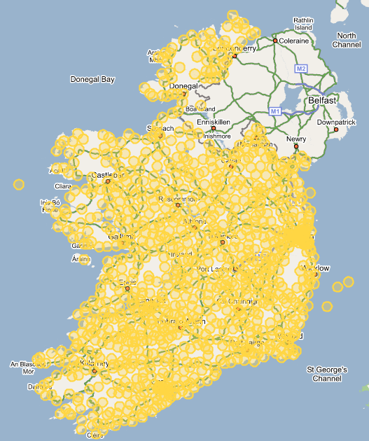
    5km radius

    5kmExchanges.png


  • Registered Users Posts: 4,290 ✭✭✭damien


    You can play with the 5km map here:

    http://handelaar.org/maps/exchanges.php

    and the 3km map here:

    http://handelaar.org/maps/exchanges-3km.php

    Huge thanks to John Handelaar for making this.


  • Registered Users Posts: 4,290 ✭✭✭damien


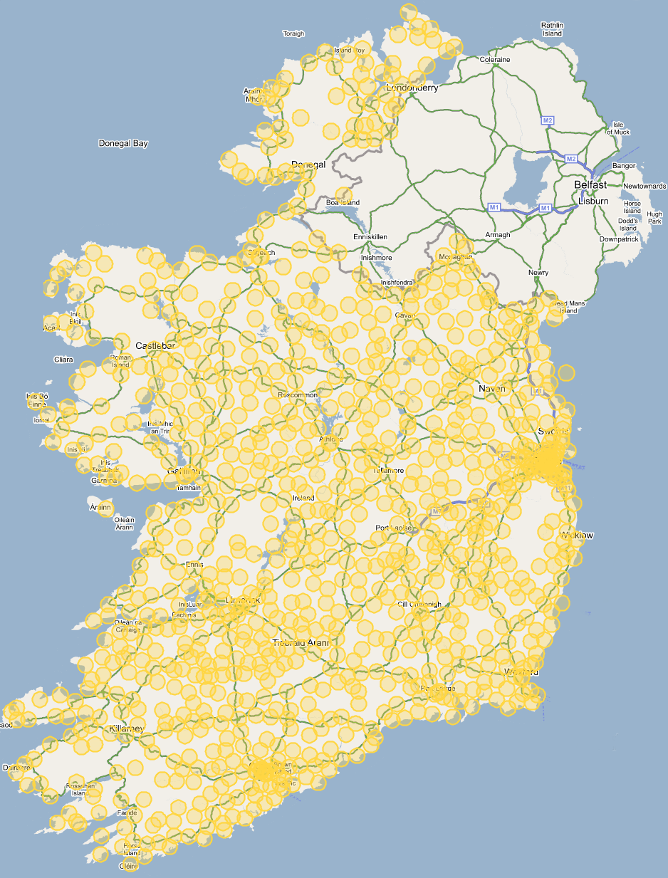
    4KMLarge.png

    4km radius. Anyone want to download this and make Northern Ireland fully green as they have 99.16% pass rate on their phone lines.


  • Technology & Internet Moderators Posts: 28,791 Mod ✭✭✭✭oscarBravo


    Just going from immediate local geographical knowledge: it looks like Knockmore and Lahardane exchanges are shown as enabled. I'd imagine both are in the hell freezing over category.

    What list was used to create the map?


  • Registered Users Posts: 4,290 ✭✭✭damien


    List on the previous page. Maybe our coords are out or the method of converting from one standard to another.


  • Advertisement
  • Technology & Internet Moderators Posts: 28,791 Mod ✭✭✭✭oscarBravo


    I don't think it's just a co-ordinates issue. Have a look:

    exchanges.png

    It just looks to me like there are way too many exchanges shown here. I'm wide open to correction.


  • Registered Users Posts: 4,290 ✭✭✭damien


    Houston, we have a monumental problem...


  • Banned (with Prison Access) Posts: 25,234 ✭✭✭✭Sponge Bob


    dude, thats \exchanges\*.* over 1100 of them :D and the outer diameter line is a tad thick

    otherwise the principle works ....bar some strange protusions in the sea off Arklow ....must be frightfully hush hush those ones . Underwater DSL what what ????


  • Closed Accounts Posts: 3,558 ✭✭✭netwhizkid


    This is a map of the exchanges right? The amount seems right to me, My area is shown as are a few more and the locations seem right. Perhaps the circles with DSL should be made a different colour? My area on it


  • Banned (with Prison Access) Posts: 25,234 ✭✭✭✭Sponge Bob


    yeah the maps have MAAM , CLIFDEN, ROUNDSTONE, KILTULLA , NEW INN , KILCONNELL , WOODFORD all are in Galway and all with no DSL installed. Some islands will be pissed off to discover they have no exchange of their own, merely being a pairgain drop off the mainland .....eg INISHEER and INISHMAAN


  • Advertisement
  • Technology & Internet Moderators Posts: 28,791 Mod ✭✭✭✭oscarBravo


    Tell you what, though: the contrast is going to be interesting when we see the *actual* coverage maps. :v:


  • Banned (with Prison Access) Posts: 25,234 ✭✭✭✭Sponge Bob


    oscarBravo wrote:
    Tell you what, though: the contrast is going to be interesting when we see the *actual* coverage maps. :v:

    Well as it happens 2 out of 3 Achill exchanges have DSL, namely Achill Sound and Corraun. Keel does not.

    I would pull those maps lest some poor bewildered eejit in Louisburgh or Lahinch or Labasheeda tries to download them and argue with Biddy about her networks coverage ....and at the traditional rural 12k - 16k speeds too .


  • Registered Users Posts: 4,290 ✭✭✭damien


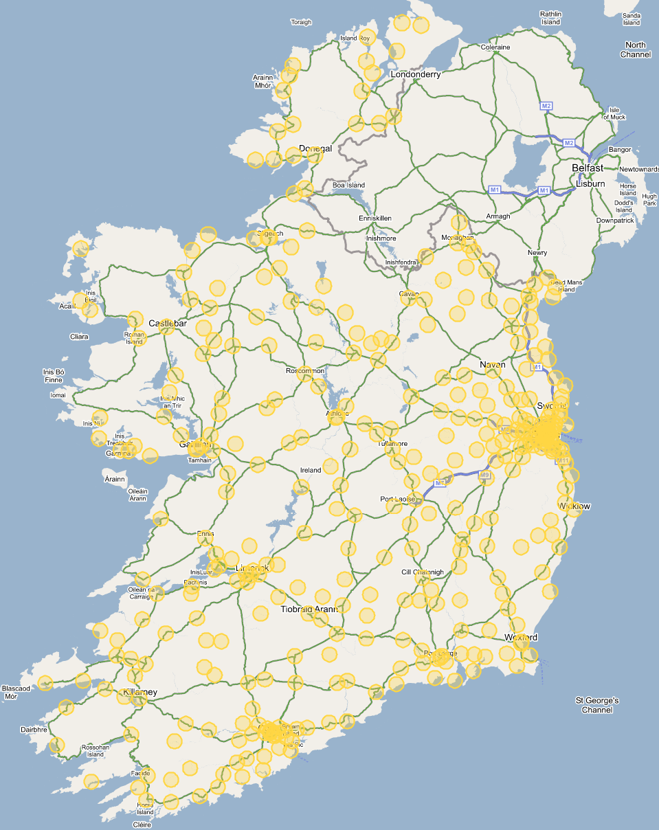
    Yup, I gave JH the list of ALL exchanges so in actuality the map looks like this:

    4kmExchangesEnabled.png

    Makes a great contrast


  • Technology & Internet Moderators Posts: 28,791 Mod ✭✭✭✭oscarBravo


    That's much more like it.


  • Registered Users Posts: 849 ✭✭✭jwt


    Good God!

    Thats some difference. And it doesn't even factor in poor line quality which reduces the coverage further.

    The stretch from Dublin to the border is well covered though. I wonder what happens if you added shading to show wireless operators. Would it tally with rural BB exchanged being enabled? not being at all cynicall here :)


    John


  • Registered Users Posts: 32,417 ✭✭✭✭watty


    If course exchanges not enabled are inside some circles! So you can be inside a circle on an non-enabled exchange.


  • Closed Accounts Posts: 1,144 ✭✭✭eircomtribunal


    watty wrote:
    So you can be inside a circle on an non-enabled exchange.
    And also important to make readers of the map aware: living within those magical circles only will give you a 80% chance to be on a DSL capable line.

    It would be interesting to do a few more detailed samples with a few exchanges, how the geographical coverage really is.

    In my case I tested a few of the telephone numbers out on one road from "my" enabled exchange town, and the pass rate did not at all extend to anything like 4 km. That is only an indication, as I would not have enough numbers around town to make a meaningful conclusion.
    P.


  • Registered Users Posts: 9,235 ✭✭✭lucernarian


    I live in that stretch between Dublin and the border. I wouldn't say we are well covered. I'd say the majority of the exchanges are alongside or a stone's throw away from the former N1, and the N2. They have fibre running along the road I believe. Btw I'm served by a non-GBS funded wireless operator.

    I noticed a few omissions on the map: Virginia and Kingscourt Co. Cavan, Kells(Ceannanus), Co. Meath and Smithborough, Co. Monaghan. And Moville, Co. Donegal.

    Is that map using the 5 km rings or 4 km rings?


  • Registered Users Posts: 4,290 ✭✭✭damien


    Latest map uses the 4Km rings and uses the list of exchanges from previous page.

    If there are any missing exchanges then post them here and we'll add them.

    The circles are yellow and not green because of the 20% failure rate.


  • Closed Accounts Posts: 1,144 ✭✭✭eircomtribunal


    damien.m wrote:
    Latest map uses the 4Km rings and uses the list of exchanges from previous page.

    The circles are yellow and not green because of the 20% failure rate.
    Two inaccuracies cancelling themselves out perhaps?:

    4 km coverage radius seems too generous in my experience.
    20% line failure rate is of lines connected to the exchange, not confined to lines terminating within the 4km (or whatever you will settle for) radius you indicate on the map.

    And also significant: DSL line pass rate is a different matter than how many landline subscribers pass the DSL test, as most of the multiple line subscribers (businesses with separate fax line and more) tend to be situated closer to towns/exchanges.
    In other words: 77% of DSL capable lines (average success rate of lines connected from enabled exchanges according to latest available Eircom SEC filing) does not at all mean that 77% of landline subscribers would pass that test, but a lot less. How much less I don't know.

    Just take care to think hard what you write in the legend to the map.

    P.


  • Advertisement
  • Registered Users Posts: 4,290 ✭✭✭damien


    Two inaccuracies cancelling themselves out perhaps?:

    Always the good word Peter.


  • Moderators, Regional North West Moderators Posts: 19,096 Mod ✭✭✭✭byte
    byte


    An exchange that is enabled!


  • Banned (with Prison Access) Posts: 25,234 ✭✭✭✭Sponge Bob


    4km is fine until the new tets system and amber program deliver something quantifiable, shrink Carraroe in Galway to 2km according to my information.

    what are the two most westerly Galway exchanges, one is most peculiar but I need a name .

    barna appears to be missing


  • Closed Accounts Posts: 4 scubaman


    Bu ti bet it still wouldnt put off Eircom, were they to merge in to the worlds fastest growing market!!!


    think of the money!!!


  • Registered Users Posts: 849 ✭✭✭jwt


    Could someone with some basic graphics apps make an animated gif out of this swapping backwards and forwards at say once a second at about 380 x 480 size and the text "eircoms plan" and "Required plan" pasted onto the relevant pics?


    John


  • Registered Users Posts: 3,884 ✭✭✭cgarvey


    jwt wrote:
    Could someone with some basic graphics apps make an animated gif out of this swapping backwards and forwards at say once a second at about 380 x 480 size and the text "eircoms plan" and "Required plan" pasted onto the relevant pics?

    Attached (for a while anyway)


  • Registered Users Posts: 849 ✭✭✭jwt


    Thanks for that Cathal.

    Strangely it looked better in my head :)
    but it gets the message across.

    Still I'll post it anyway

    John


  • Registered Users Posts: 1,733 ✭✭✭Zaphod


    AFAICS the Ballyspillane Ind Est exchange (Kerry - marked by X) which is supposed to be enabled isn't on the map. From the OSI map co-ords are 52deg04'N 9deg28'W.

    http://xs300.xs.to/xs300/06180/ballyspillane.jpg


Advertisement