Advertisement
If you have a new account but are having problems posting or verifying your account, please email us on hello@boards.ie for help. Thanks :)
Hello all! Please ensure that you are posting a new thread or question in the appropriate forum. The Feedback forum is overwhelmed with questions that are having to be moved elsewhere. If you need help to verify your account contact hello@boards.ie
Hi all! We have been experiencing an issue on site where threads have been missing the latest postings. The platform host Vanilla are working on this issue. A workaround that has been used by some is to navigate back from 1 to 10+ pages to re-sync the thread and this will then show the latest posts. Thanks, Mike.
Hi there,
There is an issue with role permissions that is being worked on at the moment.
If you are having trouble with access or permissions on regional forums please post here to get access: https://www.boards.ie/discussion/2058365403/you-do-not-have-permission-for-that#latest

Interesting Maps

189111314161

Comments

  • Registered Users, Registered Users 2 Posts: 40,515 ✭✭✭✭ohnonotgmail


    what is the 4th one?


  • Registered Users, Registered Users 2 Posts: 8,961 ✭✭✭blackwhite


    what is the 4th one?


    https://www.farandwide.com/s/hilarious-terrible-maps-ed81c3193fbb4d98

    "The Most Efficient Route Between Every Springfield in the United States"


  • Closed Accounts Posts: 5,995 ✭✭✭Ipso


    blackwhite wrote: »
    https://www.farandwide.com/s/hilarious-terrible-maps-ed81c3193fbb4d98

    "The Most Efficient Route Between Every Springfield in the United States"

    Is it by monorail? Sorry, that's more of a North Haverbrook idea.


  • Posts: 0 [Deleted User]


    What might have been - Dunwich once rivalled London as England's largest town.

    dunwichmap.jpg


  • Posts: 0 [Deleted User]


    What might have been - Dunwich once rivalled London as England's largest town.

    dunwichmap.jpg

    Global warming?


  • Registered Users, Registered Users 2 Posts: 3,340 ✭✭✭nc6000


    Global warming?

    Coastal erosion I'd say.


  • Hosted Moderators Posts: 11,362 ✭✭✭✭Scarinae


    Merlo's Map of Venice, 1676 (there is an interactive version of this map here)

    novacco_4f_288_map_o2.jpg


  • Registered Users, Registered Users 2 Posts: 8,766 ✭✭✭Quantum Erasure


    UH0PzCa.jpg?1


  • Registered Users Posts: 1,849 ✭✭✭764dak


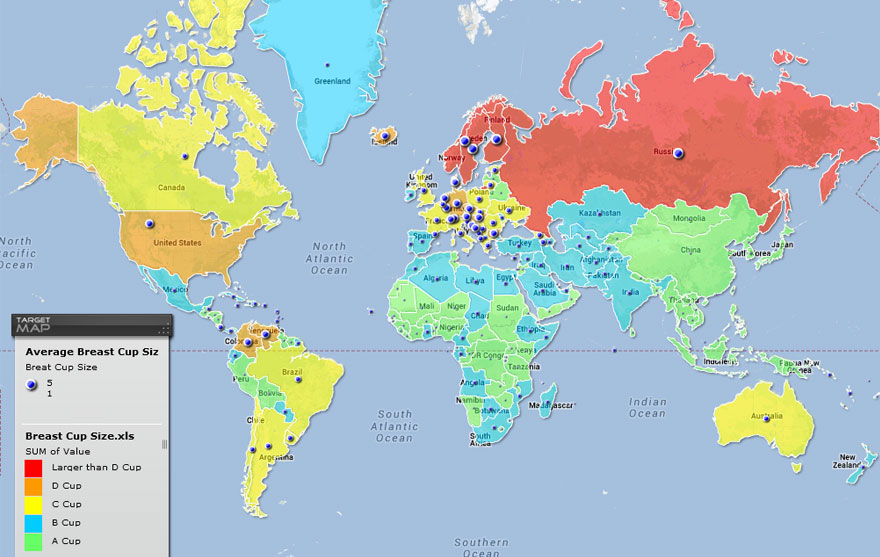
    I just came across this one (ooer missus!)

    Breast Sizes Relating to Countries
    fun-maps-12.jpg
    https://www.targetmap.com/viewer.aspx?reportId=5285

    I think this map's info is fake.


  • Advertisement
  • Registered Users, Registered Users 2 Posts: 3,862 ✭✭✭mikhail


    764dak wrote: »
    I think this map's info is fake.
    Certainly, I suspect the Russian data has been manipulated.


  • Registered Users, Registered Users 2 Posts: 32,956 ✭✭✭✭Omackeral


    Yee-Haw!

    8cdca3955df64592917f28e09b3eea13.jpeg


  • Closed Accounts Posts: 503 ✭✭✭Rufeo


    UH0PzCa.jpg?1

    That's brilliant.


  • Moderators, Science, Health & Environment Moderators, Society & Culture Moderators Posts: 6,309 Mod ✭✭✭✭mzungu


    africa_in_perspective_map-from-bigthink.jpg


  • Closed Accounts Posts: 2,779 ✭✭✭1o059k7ewrqj3n


    ^^
    mercator-vs-truesize.png


  • Registered Users, Registered Users 2 Posts: 3,723 ✭✭✭seenitall


    As parts of China go into economic lockdown, Covid19 saves the climate...

    https://earthobservatory.nasa.gov/topic/image-of-the-day


  • Advertisement
  • Registered Users, Registered Users 2 Posts: 4,431 ✭✭✭Sky King


  • Registered Users, Registered Users 2 Posts: 15,725 ✭✭✭✭AndyBoBandy


    Sky King wrote: »

    You can also use the route planner tool, to find out how long a sea voyage would take between 2 spots on the map. (You can adjust your boats speed, and the depth (draft) of your vessel (smaller boats can go closer to shore etc...)).

    A voyage on a boat doing 5 knots from Howth Marina to Dun Laoghaire Marina would take 1 hour 36 minutes. The distance is 8.1 nautical miles. (This however doesn't account for tidal currents which can either slow you down or speed you up).


  • Registered Users, Registered Users 2 Posts: 961 ✭✭✭Conchir


    Credit to PisseGuri82 on Reddit for these. He posts very cool maps on r/MapPorn, but most of them are way too big to embed here so I'll just leave some links. Check out his profile to see others, but this one of the Viking expansion around Europe, this one showing the age of the world's borders, and this one showing Britain in the Dark Ages are some of the coolest imo. The last one was published by the Ordnance Survey in 1935, and despite showing Britain and a small part of Ireland as they appeared from 410-871 AD, Bull Island is visible in Dublin Bay (which formed in the 19th Century :pac:)


  • Moderators, Social & Fun Moderators Posts: 12,894 Mod ✭✭✭✭JupiterKid


    Map of our own Milky Way galaxy, which from the most recent astronomical observations and data is believed to be a barred spiral.

    Our sun is located about two thirds the way from the galactic centre (believed to harbour a relatively quiescent supermassive black hole) and the outer edge.

    11417_63920200_4e25365a-cbc2-4e8e-ab00-c2d6480f8122.jpeg


  • Registered Users, Registered Users 2 Posts: 8,766 ✭✭✭Quantum Erasure


    "from the most recent astronomical observations and data is believed to be a barred spiral."

    there's two bars in the middle?
    maybe Milky Way and Galaxy


  • Advertisement
  • Registered Users, Registered Users 2 Posts: 5,942 ✭✭✭topper75


    Sky King wrote: »

    I know it is not the point of that map, but it doesn't inspire confidence when the m'way representations on land are over a decade out of date. :D Don't sandbanks move etc.?


  • Registered Users, Registered Users 2 Posts: 15,725 ✭✭✭✭AndyBoBandy


    Navionics are a global leader in marine navigation charts. I'm surprised they even bother adding the roads to their maps


  • Registered Users, Registered Users 2 Posts: 21,487 ✭✭✭✭Alun


    Navionics are a global leader in marine navigation charts. I'm surprised they even bother adding the roads to their maps
    They're owned by Garmin though, so there's no excuse really.


  • Registered Users, Registered Users 2 Posts: 15,725 ✭✭✭✭AndyBoBandy


    Alun wrote: »
    They're owned by Garmin though, so there's no excuse really.

    Well, their remit is marine navigation....

    Do Garmin car Sat Nav’s provide up to date locations of sand banks or lighthouses??


  • Registered Users, Registered Users 2 Posts: 40,515 ✭✭✭✭ohnonotgmail


    Alun wrote: »
    They're owned by Garmin though, so there's no excuse really.

    there is if there is a cost involved. why pay the licensing costs for up to date road maps when they are not relevant to your user base? They might be owned by garmin but that doesnt mean that garmin will give them road maps for free.


  • Registered Users, Registered Users 2 Posts: 8,766 ✭✭✭Quantum Erasure


    Navionics are a global leader in marine navigation charts. I'm surprised they even bother adding the roads to their maps

    "Roads? Where we're going, we don't need roads."


  • Registered Users, Registered Users 2 Posts: 78,491 ✭✭✭✭Victor


    Well, their remit is marine navigation....

    Do Garmin car Sat Nav’s provide up to date locations of sand banks or lighthouses??

    Well, now that you mention in, my brother drove onto a beach and his GPS announced "You are now in the water."


  • Hosted Moderators Posts: 11,362 ✭✭✭✭Scarinae


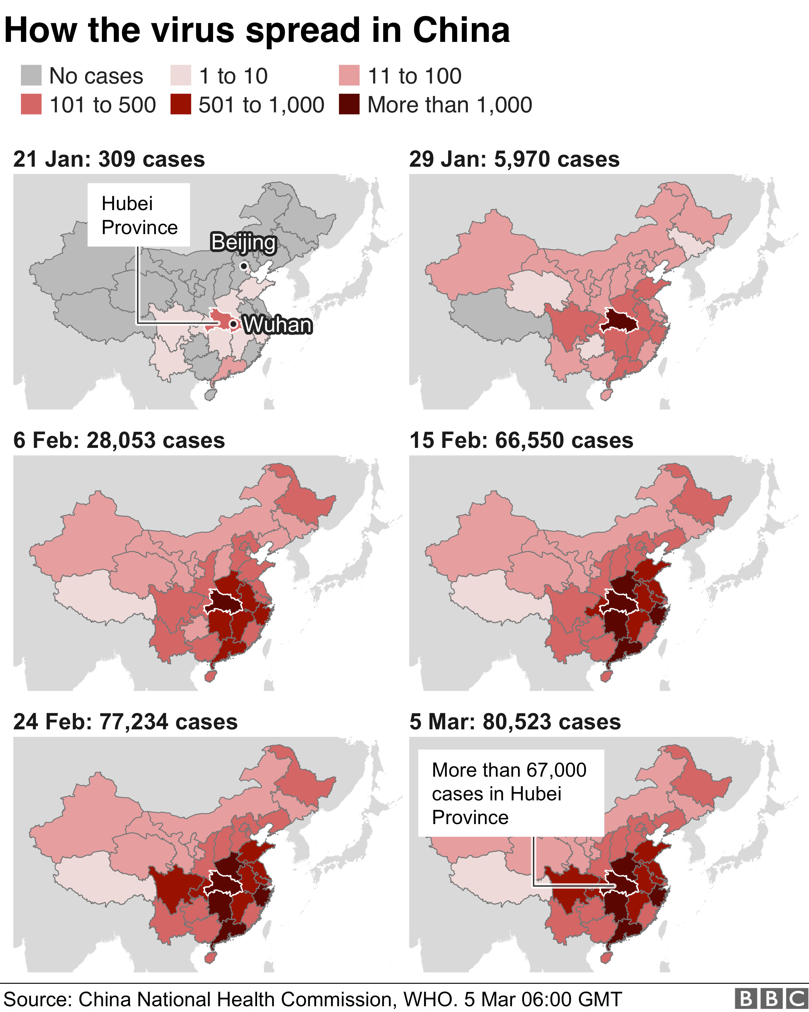
    How COVID-19/coronavirus spread in China

    _111147047_coronavirus_faceted_map_5mar-nc.png

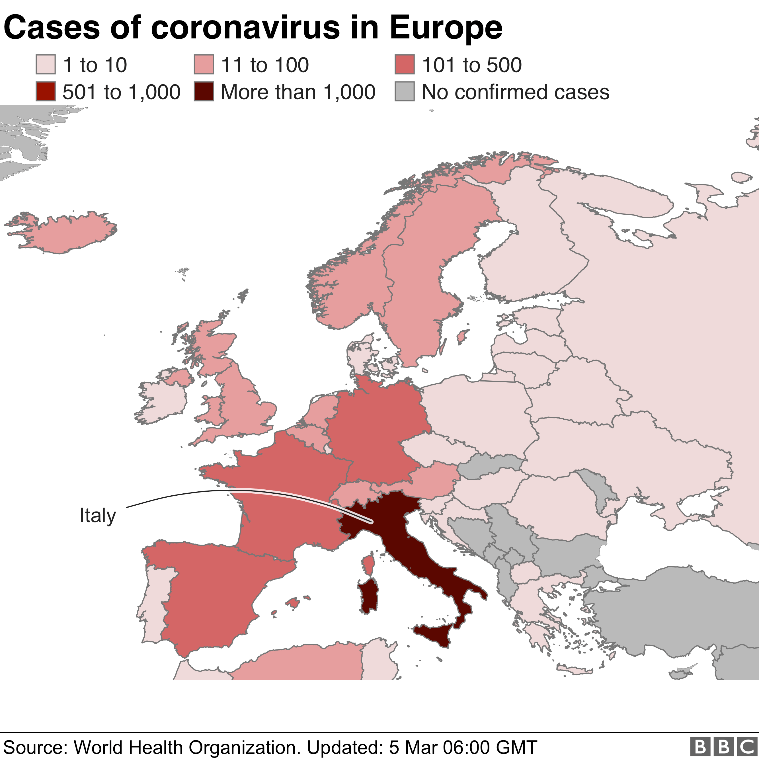
    Cases in Europe

    _111146981_europemapfinal_5mar_v2-nc.png


  • Moderators, Recreation & Hobbies Moderators, Science, Health & Environment Moderators, Technology & Internet Moderators Posts: 92,530 Mod ✭✭✭✭Capt'n Midnight


    "from the most recent astronomical observations and data is believed to be a barred spiral."

    there's two bars in the middle?
    maybe Milky Way and Galaxy
    It's a spacebar :pac:


  • Moderators, Recreation & Hobbies Moderators, Science, Health & Environment Moderators, Technology & Internet Moderators Posts: 92,530 Mod ✭✭✭✭Capt'n Midnight


    Maps of Biochemical Pathways : Zoom all the way out for overview

    Part 1: Metabolic Pathways

    Part 2: Cellular and Molecular Processes


  • Advertisement
  • Moderators, Category Moderators, Music Moderators, Regional East Moderators, Regional Midlands Moderators, Regional Midwest Moderators, Regional Abroad Moderators, Regional North Mods, Regional West Moderators, Regional South East Moderators, Regional North East Moderators, Regional North West Moderators, Regional South Moderators Posts: 8,037 CMod ✭✭✭✭Gaspode


    So cool!


  • Registered Users, Registered Users 2 Posts: 11,073 ✭✭✭✭Tom Mann Centuria


    VyAX2G2.jpg

    Oh well, give me an easy life and a peaceful death.


  • Registered Users, Registered Users 2 Posts: 4,814 ✭✭✭harry Bailey esq


    VyAX2G2.jpg

    Very concise.


  • Banned (with Prison Access) Posts: 9,078 ✭✭✭IAMAMORON


    Maps of Biochemical Pathways : Zoom all the way out for overview

    Part 1: Metabolic Pathways

    Part 2: Cellular and Molecular Processes

    Thanks for posting, but I quite genuinely have no clue what is going on there. My bad.


  • Registered Users, Registered Users 2 Posts: 7,213 ✭✭✭bobbysands81


    Scarinae wrote: »
    How COVID-19/coronavirus spread in China

    _111147047_coronavirus_faceted_map_5mar-nc.png

    Cases in Europe

    _111146981_europemapfinal_5mar_v2-nc.png

    Completely erroneous to lump the north of Ireland in with the “UK” for the Coronavirus.

    Statistically it makes far more sense to report incidences for the island of Ireland.


  • Banned (with Prison Access) Posts: 9,078 ✭✭✭IAMAMORON


    Completely erroneous to lump the north of Ireland in with the “UK” for the Coronavirus.

    Statistically it makes far more sense to report incidences for the island of Ireland.

    Definitely a civil rights issue Robert, disgraceful.

    That virus wants political status.... right nie.


  • Registered Users, Registered Users 2 Posts: 14,568 ✭✭✭✭cj maxx


    IAMAMORON wrote: »
    Definitely a civil rights issue Robert, disgraceful.

    That virus wants political status.... right nie.

    Bullsh1t. There was loads of cross border interaction during the troubles. Just because the Dublin crowd weren't part of it is irrelevant.
    It still makes it an island wide issue not a northern or southern one


  • Registered Users, Registered Users 2 Posts: 7,213 ✭✭✭bobbysands81


    IAMAMORON wrote: »
    Definitely a civil rights issue Robert, disgraceful.

    That virus wants political status.... right nie.

    Completely missing the point but you’re sooooooo edgy.


  • Registered Users, Registered Users 2 Posts: 19,085 ✭✭✭✭BonnieSituation


    Maps of Biochemical Pathways : Zoom all the way out for overview

    Part 1: Metabolic Pathways

    Part 2: Cellular and Molecular Processes

    It doesn't even matter that I haven't a notion of what is happening for the most part, but they are beautiful pieces of visual data.


  • Advertisement
  • Registered Users, Registered Users 2 Posts: 34,009 ✭✭✭✭NIMAN


    Very concise.

    Did anyone else look round the map to see if there was a 2nd?

    Just me then.


  • Registered Users, Registered Users 2 Posts: 1,143 ✭✭✭Psychlops


    Completely erroneous to lump the north of Ireland in with the “UK” for the Coronavirus.

    Statistically it makes far more sense to report incidences for the island of Ireland.


    You are aware that the 6 counties that make up the North of Ireland are part of the UK & a different Country & jurisdiction with different laws & Government & services & everything else that is not in the 26 Counties of the Republic of Ireland arent you?


  • Registered Users, Registered Users 2 Posts: 19,085 ✭✭✭✭BonnieSituation


    Psychlops wrote: »
    You are aware that the 6 counties that make up the North of Ireland are part of the UK & a different Country & jurisdiction with different laws & Government & services & everything else that is not in the 26 Counties of the Republic of Ireland arent you?

    From the pov of it being a viral outbreak, it very much makes sense to report the island as one. However, there are obvious issues surrounding that as you pointed out.

    When the COVID-19 case in Belfast was announced, the HSE had a press conference. The outbreak in the north is an Irish outbreak, and the containment of the virus is an all-island issue.

    I remember how Foot and Mouth was handled here in 2001. It was an all-island issue.

    Plus the cows are Irish...

    Anyway I digress...


  • Registered Users, Registered Users 2 Posts: 19,085 ✭✭✭✭BonnieSituation


    NIMAN wrote: »
    Did anyone else look round the map to see if there was a 2nd?

    Just me then.

    I did after I read this.


  • Registered Users, Registered Users 2 Posts: 3,862 ✭✭✭mikhail


    Completely missing the point but you’re sooooooo edgy.
    I'm sure it respects the Luxembourg boarder equally well. This is a stupid thing to get worked up over.


  • Banned (with Prison Access) Posts: 9,078 ✭✭✭IAMAMORON


    The Irish Sea, with St Georges Channel.

    AC1121.jpg


  • Advertisement
  • Registered Users, Registered Users 2 Posts: 16,190 ✭✭✭✭Pherekydes


    NIMAN wrote: »
    Did anyone else look round the map to see if there was a 2nd?

    Just me then.

    I certainly double checked the USA. :pac:


  • Registered Users, Registered Users 2 Posts: 7,213 ✭✭✭bobbysands81


    Psychlops wrote: »
    You are aware that the 6 counties that make up the North of Ireland are part of the UK & a different Country & jurisdiction with different laws & Government & services & everything else that is not in the 26 Counties of the Republic of Ireland arent you?

    How is any of that relevant to the spread of Coronavirus?

    You are aware that the Coronavirus doesn’t recognise that there’s a border on the island of Ireland? Therefore any response to the virus on the island should be done on a whole island approach in order to minimise the risk of further spreading. It’s a common sense approach, not a political one.

    If people in Finchley in England get it there’s a far less chance of people in Dublin getting it as a result then there is if someone in Belfast has it.


  • Registered Users, Registered Users 2 Posts: 7,213 ✭✭✭bobbysands81


    From the pov of it being a viral outbreak, it very much makes sense to report the island as one. However, there are obvious issues surrounding that as you pointed out.

    When the COVID-19 case in Belfast was announced, the HSE had a press conference. The outbreak in the north is an Irish outbreak, and the containment of the virus is an all-island issue.

    I remember how Foot and Mouth was handled here in 2001. It was an all-island issue.

    Plus the cows are Irish...

    Anyway I digress...

    It’s common sense... but not to all.


  • Registered Users, Registered Users 2 Posts: 5,907 ✭✭✭Charles Babbage


    Any know why there's such a high number in the Dundalk, Cooley, Newry area?


    Between the Pale and the Plantation. One of the last area of native speakers on the East coast, into the early 20th century in Omeath and upland South Armagh.


  • Registered Users, Registered Users 2 Posts: 2,381 ✭✭✭Westernyelp


    How is any of that relevant to the spread of Coronavirus?

    You are aware that the Coronavirus doesn’t recognise that there’s a border on the island of Ireland? Therefore any response to the virus on the island should be done on a whole island approach in order to minimise the risk of further spreading. It’s a common sense approach, not a political one.

    If people in Finchley in England get it there’s a far less chance of people in Dublin getting it as a result then there is if someone in Belfast has it.

    FFS please do not infect another healthy thread with the Shaggin Corona virus


  • Advertisement
Advertisement