Advertisement
If you have a new account but are having problems posting or verifying your account, please email us on hello@boards.ie for help. Thanks :)
Hello all! Please ensure that you are posting a new thread or question in the appropriate forum. The Feedback forum is overwhelmed with questions that are having to be moved elsewhere. If you need help to verify your account contact hello@boards.ie
Hi all! We have been experiencing an issue on site where threads have been missing the latest postings. The platform host Vanilla are working on this issue. A workaround that has been used by some is to navigate back from 1 to 10+ pages to re-sync the thread and this will then show the latest posts. Thanks, Mike.
Hi there,
There is an issue with role permissions that is being worked on at the moment.
If you are having trouble with access or permissions on regional forums please post here to get access: https://www.boards.ie/discussion/2058365403/you-do-not-have-permission-for-that#latest

Dublin - BusConnects

1515254565776

Comments

  • Registered Users, Registered Users 2 Posts: 19,085 ✭✭✭✭BonnieSituation


    cgcsb wrote: »
    The revised corridors are up. Some improvements on the last iteration and quite a few disapointments including a climb down in design in Rathmines and mobhi road. Frustratingly the designs continue to refuse to tie in to the proposed liffey cycle route and vice versa. Cycling seems to have improved at many locations. Many improvements to public realm proposed and one glaring missed opportunity at Phibsboro cross roads which will remain heavily trafficked for the foreseeable. Maybe this will be addressed in the future when designing the orbital corridors.

    Am I missing something in your post?

    Here's Heuston as part of the Lucan Road proposals:

    504574.JPG


  • Registered Users, Registered Users 2 Posts: 9,761 ✭✭✭cgcsb


    Am I missing something in your post?

    Here's Heuston as part of the Lucan Road proposals:

    504574.JPG

    Have a look at where queen st meets the quays the designs don't match


  • Registered Users, Registered Users 2 Posts: 9,761 ✭✭✭cgcsb


    Qrt wrote: »
    Are bus lanes still continuous though? As in either through lanes or queue relocation signalling? I’m in work and can’t read the docs.

    No there's a greater reliance on bus gates. But as of yet there are no plans to enforce them or even our current bus lanes.


  • Registered Users, Registered Users 2 Posts: 9,761 ✭✭✭cgcsb


    I note that the media is distracted with corona. Whether that's a good thing or a bad thing is up to you. The media usually do hatchet jobs on pt infrastructure. And write from the point of view of low iq skoda drivers who only read headlines.


  • Registered Users, Registered Users 2 Posts: 19,085 ✭✭✭✭BonnieSituation


    cgcsb wrote: »
    Have a look at where queen st meets the quays the designs don't match

    Will do.

    I'm slowly making my way through each one. Liffey Valley and Ballyfermot currently on the go.

    What I find interesting is how they managed to justify closing the O'Hogan Road/Ballyfermot Road junction but somehow are keeping the The Oval/Lucan Road junction open. And not only that, they are proposing a bus only right turn from the Lucan Road to Mill Lane (at the Apple Green garage). I can see some advantage to that in a future routing from the Old Lucan Road but the Oval is a serious pinch-point.


  • Registered Users Posts: 920 ✭✭✭Last Stop


    Am I missing something in your post?

    Here's Heuston as part of the Lucan Road proposals:

    504574.JPG

    Wow that’s an awful design. Losing 2 bus stops outside the station and converting it to 2 way traffic.
    This indicates the plans to proceed with buses coming down the hill from James and across the Luas bridge which will be a complete disaster.

    And the staggered junction for pedestrians to the Quays still remains and if anything the island has gotten smaller to accommodate cyclists.

    Why are they proposing to realign the Luas platform??


  • Registered Users, Registered Users 2 Posts: 9,761 ✭✭✭cgcsb


    It looks like they've routed a cycle lane down the luas tracks on the western side. The whole thing is quite badly drawn. I'd imagine lack of a second person checking.


  • Registered Users, Registered Users 2 Posts: 8,543 ✭✭✭dublinman1990


    That Luas platform at Heuston Station is normally 3 platforms. The NTA must be cutting off the extra platform in the middle there with that CBC proposal with the Liffey cycle route. Are there no trams that terminate at Heuston anymore? I'm thinking that it is Connolly - Red Cow for short journeys rather than Connolly - Heuston.

    The 2 way traffic with the bus shelters outside Heuston is confusing to note as well. One of the proposed bus stops located right outside Heuston is near a road marking which goes onto the Heuston car park. It will be a disaster if buses terminate there like the Airlink & will have the potential to hold up traffic behind them unless it was for buses only? I don't get why there is a right turn available at the lights as soon the Luas leaves for/arrives from St James Hospital. And there is no left turn available coming in from the N7. Why is that? It seems very pointless having that no left turn restriction there. If a bus comes down from the Ballyfermot or N7 direction it will have to continue to drive straight ahead when it gets to the next stops on the quays.


  • Registered Users Posts: 920 ✭✭✭Last Stop


    Ahhhh I see the cycle lane now.
    All I can say is wow!!
    So what they are actually doing is removing the platform nearest the station (the one currently used to travel to the city centre) to accommodate a cycle lane.
    They seriously expect that the massive crowds who use that platform every morning are now going to have to cross the cycle lane and the Luas track to board.

    That’s an accident waiting to happen!! I mean there is often security on that platform due to the amount of people. Add in the fact that there is no ticketing machines on the island and it’s just idiotic.

    There still is a service between Heuston and Connolly every morning too using the middle platform.


  • Registered Users, Registered Users 2 Posts: 8,543 ✭✭✭dublinman1990


    Last Stop wrote: »
    Ahhhh I see the cycle lane now.
    All I can say is wow!!
    So what they are actually doing is removing the platform nearest the station (the one currently used to travel to the city centre) to accommodate a cycle lane.
    They seriously expect that the massive crowds who use that platform every morning are now going to have to cross the cycle lane and the Luas track to board.

    That’s an accident waiting to happen!! I mean there is often security on that platform due to the amount of people. Add in the fact that there is no ticketing machines on the island and it’s just idiotic.

    There still is a service between Heuston and Connolly every morning too using the middle platform.

    Yep. I can see it. That is a really awful design. It is way too thin, going from the map drawings, to have the cycle lane pass the Luas in that section of the line.


  • Advertisement
  • Registered Users Posts: 7 djam17


    Its seems foolish to remove a Luas platform. Is it not time to consider diverting general traffic away from the front of heuston. Possibly sending inbound traffic through south circular onto Conyngham Rd and onto the quays. There are plans to send a road through the guinness yard adjacent to the luas platform, cut out the bend where st johns road turns onto the quays and make a public transport plaza at the front of heuston. This is possibly dictated by a Dart underground station in that location so............................wishful thinking


  • Registered Users Posts: 10,666 ✭✭✭✭MJohnston


    They aren't removing any platforms, I'm not sure why Last Stop is saying that.


  • Registered Users Posts: 920 ✭✭✭Last Stop


    MJohnston wrote: »
    They aren't removing any platforms, I'm not sure why Last Stop is saying that.

    They are!! It clearly states on the drawing “realigned Luas platform” and there is a cycle lane proposed between the current Luas platform and track. That’s not possible without removing the platform.


  • Registered Users, Registered Users 2 Posts: 5,818 ✭✭✭donvito99


    Realign does not mean remove.


  • Registered Users Posts: 10,666 ✭✭✭✭MJohnston


    Last Stop wrote: »
    They are!! It clearly states on the drawing “realigned Luas platform” and there is a cycle lane proposed between the current Luas platform and track. That’s not possible without removing the platform.

    The realignment looks to me to move the middle island about 5m south - you can see the outline of the existing island, as well as the filled grey new position.

    They aren't adding a cycle lane there either - what you've done here is not bothered to actually go looking at the proper plans:

    L0QVLCe.png


  • Registered Users Posts: 920 ✭✭✭Last Stop


    MJohnston wrote: »
    The realignment looks to me to move the middle island about 5m south - you can see the outline of the existing island, as well as the filled grey new position.

    They aren't adding a cycle lane there either - what you've done here is not bothered to actually go looking at the proper plans:

    L0QVLCe.png

    So what is the red line being shown running alongside the platform. The exact same colour as the cycle lane?


  • Moderators, Sports Moderators Posts: 27,303 Mod ✭✭✭✭Podge_irl


    Last Stop wrote: »
    So what is the red line being shown running alongside the platform. The exact same colour as the cycle lane?

    The line that, generously, is at most a tenth the size of a cycle lane? Its delineating the boundary of the luas tracks.


  • Registered Users, Registered Users 2 Posts: 7,045 ✭✭✭Pete_Cavan


    It's just a line, probably from another layer in their drawing software which should have been turned off. It is not supposed to be a cycle lane.


  • Registered Users, Registered Users 2 Posts: 5,818 ✭✭✭donvito99


    What is this, a bicycle lane for ants?


  • Advertisement
  • Registered Users Posts: 920 ✭✭✭Last Stop


    Pretty amateur mistake to make.


  • Registered Users Posts: 10,666 ✭✭✭✭MJohnston


    Last Stop wrote: »
    So what is the red line being shown running alongside the platform. The exact same colour as the cycle lane?

    It's not the exact same colour as the cycle lane, you can see that at the bottom of my screenshot where it crosses the actual cycling lane:

    jZhPUd6.png

    It's also clearly not the size of a cycling lane. It's just a stroke on the fill around the Luas tracks. Poorly chosen colour perhaps, but pretty obvious when you're looking at the actual PDF.

    Also, just logically speaking, why would they bother adding a cycle lane there in such a disruptive location when the same movements can be easily completed using the other cycle lanes?


  • Registered Users Posts: 10,666 ✭✭✭✭MJohnston


    Last Stop wrote: »
    Pretty amateur mistake to make.

    It's okay, we've all done it before, no need to blame yourself


  • Registered Users, Registered Users 2 Posts: 7,045 ✭✭✭Pete_Cavan


    The best thing to do here is CPO the corner of the Guinness yard, shift the road eastward and create a bay for buses coming from SJRW to pull in immediately east of the Luas platform. Leave one way traffic between the Luas and Heuston.


  • Registered Users Posts: 920 ✭✭✭Last Stop


    MJohnston wrote: »
    It's not the exact same colour as the cycle lane, you can see that at the bottom of my screenshot where it crosses the actual cycling lane:

    jZhPUd6.png

    It's also clearly not the size of a cycling lane. It's just a stroke on the fill around the Luas tracks. Poorly chosen colour perhaps, but pretty obvious when you're looking at the actual PDF.

    Also, just logically speaking, why would they bother adding a cycle lane there in such a disruptive location when the same movements can be easily completed using the other cycle lanes?

    It’s even less obvious when looking at the PDF at full scale. It’s almost identical in colour.
    I obviously wasn’t the only one to assume it was a cycle lane either


  • Registered Users, Registered Users 2 Posts: 7,045 ✭✭✭Pete_Cavan


    Last Stop wrote: »
    It’s even less obvious when looking at the PDF at full scale. It’s almost identical in colour.
    I obviously wasn’t the only one to assume it was a cycle lane either

    It doesn't matter. Get over it. Feel free to have the last word on it, like you always do.


  • Advertisement
  • Registered Users Posts: 10,666 ✭✭✭✭MJohnston


    Last Stop wrote: »
    It’s even less obvious when looking at the PDF at full scale. It’s almost identical in colour.
    I obviously wasn’t the only one to assume it was a cycle lane either

    You really just can't hold your hands up and admit you got it wrong?


  • Registered Users Posts: 920 ✭✭✭Last Stop


    MJohnston wrote: »
    You really just can't hold your hands up and admit you got it wrong?

    You really just can’t admit that Busconnects got it wrong with a drafting error?


  • Registered Users, Registered Users 2 Posts: 15,115 ✭✭✭✭loyatemu


    MJohnston wrote: »
    You really just can't hold your hands up and admit you got it wrong?

    people need to make more use of Boards' "ignore" function.

    image.png


  • Registered Users, Registered Users 2 Posts: 7,045 ✭✭✭Pete_Cavan


    Interestingly the same coloured line appears on the other side of the Luas tracks as well, it just had a black line on top of it. Seems intentional rather than an error.


  • Registered Users Posts: 10,666 ✭✭✭✭MJohnston


    Pete_Cavan wrote: »
    Interestingly the same coloured line appears on the other side of the Luas tracks as well, it just had a black line on top of it. Seems intentional rather than an error.

    Yeah, intentional, but as I said, a poor colour choice, but otherwise very much obvious if you are looking at the real PDF and not just relying on third-hand screenshots.


  • Advertisement
  • Registered Users, Registered Users 2 Posts: 7,045 ✭✭✭Pete_Cavan


    I see that they are proposing to shift the Scherzer bridges either side and put a new full width road bridge in between.


  • Moderators, Science, Health & Environment Moderators Posts: 19,873 Mod ✭✭✭✭Sam Russell


    Mod: Can the squabbles stop please.


  • Registered Users Posts: 10,666 ✭✭✭✭MJohnston


    Pete_Cavan wrote: »
    I see that they are proposing to shift the Scherzer bridges either side and put a new full width road bridge in between.

    I'm curious as to the logistics of this, how they can do it while retaining access.


  • Registered Users, Registered Users 2 Posts: 15,115 ✭✭✭✭loyatemu


    Pete_Cavan wrote: »
    I see that they are proposing to shift the Scherzer bridges either side and put a new full width road bridge in between.

    they show a 2-way cycle lane all the way down to the Beckett bridge, but there's no way there's space for a cycle lane and footpath where the Dublin Docklands office building is.


  • Registered Users, Registered Users 2 Posts: 7,045 ✭✭✭Pete_Cavan


    loyatemu wrote: »
    they show a 2-way cycle lane all the way down to the Beckett bridge, but there's no way there's space for a cycle lane and footpath where the Dublin Docklands office building is.

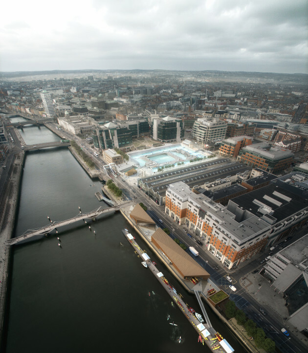
    That building is to be demolished to make way for the white water rafting course building which I assume will be a bit narrower. The road also looks like it will be a bit narrower.


  • Registered Users, Registered Users 2 Posts: 15,115 ✭✭✭✭loyatemu


    Pete_Cavan wrote: »
    That building is to be demolished to make way for the white water rafting course building which I assume will be a bit narrower. The road also looks like it will be a bit narrower.

    The rafting centre is in Georges Dock, the Docklands office building is on the river side of the quays here: https://goo.gl/maps/a6LuCjLaN4c1s6id8

    I haven't heard of any plans to demolish it though as the DDDA is long gone, I'm not sure what it's now used for (extra offices for the council I guess, and somewhere for kids to jump off into the river).


  • Registered Users, Registered Users 2 Posts: 15,115 ✭✭✭✭loyatemu


    terrrible cycle-lane routing here at UCD:

    image.png


  • Registered Users Posts: 10,666 ✭✭✭✭MJohnston


    loyatemu wrote: »
    The rafting centre is in Georges Dock, the Docklands office building is on the river side of the quays here: https://goo.gl/maps/a6LuCjLaN4c1s6id8

    I haven't heard of any plans to demolish it though as the DDDA is long gone, I'm not sure what it's now used for (extra offices for the council I guess, and somewhere for kids to jump off into the river).

    No the white water rafting centre plans include the demolition of those DDDA buildings, as seen here:

    ?width=630&version=4907141


  • Registered Users, Registered Users 2 Posts: 16,004 ✭✭✭✭Spanish Eyes


    Will do.

    I'm slowly making my way through each one. Liffey Valley and Ballyfermot currently on the go.

    What I find interesting is how they managed to justify closing the O'Hogan Road/Ballyfermot Road junction but somehow are keeping the The Oval/Lucan Road junction open. And not only that, they are proposing a bus only right turn from the Lucan Road to Mill Lane (at the Apple Green garage). I can see some advantage to that in a future routing from the Old Lucan Road but the Oval is a serious pinch-point.

    I've been reading the maps and the info and am a bit confused about the Oval junction, wonder if you know more.

    Seems to me that there will a right turn bus only from R148 to the Old Lucan Road serving Stewarts and Palmerstown Village. There are currently no buses serving the village apart from the 18 which does not use R148 anyway. But I guess they are going to get maybe the local no.26 to serve the village or something.

    It's not clear, but I am thinking the the current North side of the Oval/Applegreen/R148 junction will have buses turning left inbound onto the Chapelizod by pass.

    I presume this means that car traffic will no longer be able to use the Northside of the junction if it is to be bus only. Can see Kennelsfort Junction rammed as a result, but hey ho.

    This is the Lucan route 06.

    At the R148 signalised junction with the Old Lucan Road/the Oval a new westbound, bus only, right turn lane is provided on the R148 to facilitate bus services serving Palmerstown Village. An additional strip of land acquisition will be required from the western edge of the petrol filling station at this location to accommodate this new bus movement which was not included in the EPR. In addition, new bus stops are provided on the Old Lucan Road to serve Mill Lane/Stewarts Hospital


  • Registered Users, Registered Users 2 Posts: 19,085 ✭✭✭✭BonnieSituation


    I've been reading the maps and the info and am a bit confused about the Oval junction, wonder if you know more.

    Seems to me that there will a right turn bus only from R148 to the Old Lucan Road serving Stewarts and Palmerstown Village. There are currently no buses serving the village apart from the 18 which does not use R148 anyway. But I guess they are going to get maybe the local no.26 to serve the village or something.

    It's not clear, but I am thinking the the current North side of the Oval/Applegreen/R148 junction will have buses turning left inbound onto the Chapelizod by pass.

    I presume this means that car traffic will no longer be able to use the Northside of the junction if it is to be bus only. Can see Kennelsfort Junction rammed as a result, but hey ho.

    This is the Lucan route 06.

    At the R148 signalised junction with the Old Lucan Road/the Oval a new westbound, bus only, right turn lane is provided on the R148 to facilitate bus services serving Palmerstown Village. An additional strip of land acquisition will be required from the western edge of the petrol filling station at this location to accommodate this new bus movement which was not included in the EPR. In addition, new bus stops are provided on the Old Lucan Road to serve Mill Lane/Stewarts Hospital

    Here's an image of the plan for the Oval junction:
    No indication as to what bus will use the Village now but as you say, it would make sense for the 26 to now use this section of Mill Lane and continue through the village and turn left up the Kennelsfort Road (If it is to continue its current routing).

    Always remember that the lands at the Kennelsfort junction exist as they do as a freeflow junction was accommodated for in its original construction.

    504700.jpg


  • Advertisement
  • Moderators, Science, Health & Environment Moderators Posts: 5,148 Mod ✭✭✭✭spacetweek


    loyatemu wrote: »
    they show a 2-way cycle lane all the way down to the Beckett bridge, but there's no way there's space for a cycle lane and footpath where the Dublin Docklands office building is.

    You could remove the trees.


  • Closed Accounts Posts: 24 William Legrande


    They want to rip the arse out of Shankill village and there's be a few votes there for SF


    The new plans for Shankill don't look as vandalistic as before, at least at first sight.


  • Registered Users, Registered Users 2 Posts: 6,869 ✭✭✭Alkers


    loyatemu wrote: »
    terrrible cycle-lane routing here at UCD:

    image.png

    At least there is a yield for the bus-lane to the cycle lane.


  • Registered Users, Registered Users 2 Posts: 15,115 ✭✭✭✭loyatemu


    spacetweek wrote: »
    You could remove the trees.

    still wouldn't be enough space but as others have pointed out that building is due to be replaced by a (presumably) narrower one.
    The new plans for Shankill don't look as vandalistic as before, at least at first sight.

    they've basically given up on any bus or cycle priority in Shankill Village. On street parking remains though.


  • Registered Users, Registered Users 2 Posts: 14,479 ✭✭✭✭Thelonious Monk


    How satisfying is this to watch? Imagine having this in Dublin? I just can't see this ever happening here, especially with all the taxis. I think I need some time alone with this video...

    https://twitter.com/HorneJerome/status/1235568774729908226


  • Moderators, Computer Games Moderators, Recreation & Hobbies Moderators Posts: 10,399 Mod ✭✭✭✭CatInABox


    Due to Covid-19, this will now have another consultation later this year. As disappointing as this is, it's not that surprising, and is probably the right thing to do. A consultation is a bit pointless if no one can participate.

    https://twitter.com/BusConnects/status/1243212328889397248


  • Registered Users Posts: 209 ✭✭Bsharp


    Alkers wrote: »
    At least there is a yield for the bus-lane to the cycle lane.

    For the section along UCD boundary this has been the source of much debate and doubt it's finalised. Talk of a separate cycle only signal at the junction to assist with priority between cyclists and buses from a stop start. Send in recommendations on design as all to play for.


  • Moderators, Entertainment Moderators, Science, Health & Environment Moderators Posts: 14,463 Mod ✭✭✭✭marno21


  • Registered Users, Registered Users 2 Posts: 233 ✭✭Heartbreak Hank


    Pity they can't do an overnight drop of the full network redesign at the moment. Lots of people will be phasing back into work etc so there would be a more gradual adjustment.


  • Advertisement
  • Registered Users, Registered Users 2 Posts: 17,941 ✭✭✭✭LXFlyer


    tom1ie wrote: »
    One question I have about these orbitals:
    Will there be continuous bus lanes/ bus priority on these routes and if so how long before this infrastructure is in place to service the new orbitals.
    Thanks.

    Apologies only seen the mid note after I posted.
    Off to the bus connects forum with me!!

    To answer this question posted in the Metrolink thread, at the moment the only infrastructure planned is on the radial routes to/from the city centre.

    Any infrastructure on the orbital routes will follow after the radial routes are completed.

    To be fair some of the roads served by the planned outer orbital routes do already have some bus priority measures in place, but on many of the inner routes, the notion of continuous bus lanes is fanciful to say the least given the lack of available space.

    While the delivery of the additional orbital routes is long overdue, I’d have serious concerns about how effective the likes of the O, S2 and S4 can be if they’re likely to be snarled up in the diverted traffic from the radial corridors, given that those routes are significantly down the pecking order for bus priority infrastructure.


Advertisement