Advertisement
If you have a new account but are having problems posting or verifying your account, please email us on hello@boards.ie for help. Thanks :)
Hello all! Please ensure that you are posting a new thread or question in the appropriate forum. The Feedback forum is overwhelmed with questions that are having to be moved elsewhere. If you need help to verify your account contact hello@boards.ie

Carrantuohill easiest/safest route

Options
12467

Comments

  • Registered Users Posts: 53 ✭✭shelly6


    I climbed a few weeks ago and the devil's ladder was definitely open.


  • Registered Users Posts: 16,500 ✭✭✭✭DEFTLEFTHAND


    I climbed it last Thursday via the devil's ladder. I found going up the ladder to be tough going but manageable if your relatively fit. Descending the ladder was quite scary at times, there's lots of loose stone and shale and the possibility is there to be seriously injured. If I was doing it again Id definitely try and descend via the zig zag route which Im told is longer but safer.


  • Registered Users Posts: 435 ✭✭mmclo


    Did it on Thursday and info here very helpful. Devils ladder is seriously tough I felt even if very safety conscious and hard going physically


  • Registered Users Posts: 297 ✭✭W0LFMAN


    I just did the Carrauntoohil 27/08/2011

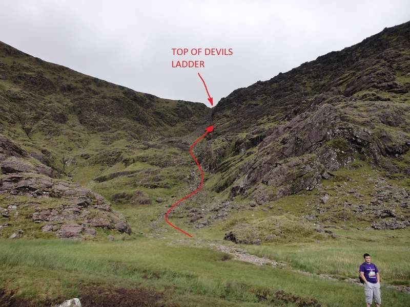
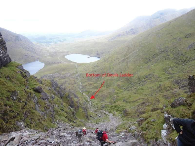
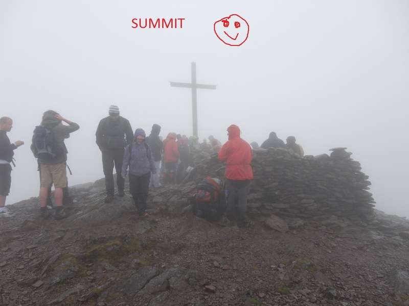
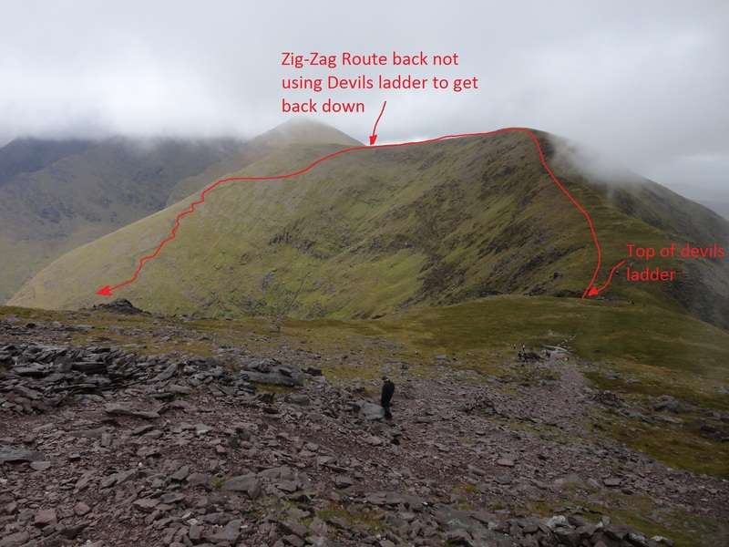
    Hopefully pics work below.

    I found the route physically hard... But i would have to say im seriously out of shape.. But Grit and determination got me through it in the end... By Far the hardest assent Ive done so far in Ireland.

    Devils ladder is Dangerious but good focus and constant attention will get you up.

    took me 1 hour from Carpark to Bottom of devils ladder.
    1 hour to get to top of devils ladder
    45 minutes from top of devils ladder to summit
    30 minutes from summit to top of devils ladder
    1:15 down the zig-zag route
    1 hour deom bottom to back to carpark.

    With plenty of breaks inbetween.

    dsc00239a.jpg

    dsc00270un.jpg

    dsc00289gk.jpg

    dsc00302de.jpg


  • Registered Users Posts: 2,208 ✭✭✭mattser


    Well done Wolfman, and great photos too.


  • Advertisement
  • Closed Accounts Posts: 4,930 ✭✭✭duckysauce


    hi anyone have a gpx route up/down via the zig-zag route?

    cheers


  • Registered Users Posts: 2,816 ✭✭✭sparrowcar


    duckysauce wrote: »
    hi anyone have a gpx route up/down via the zig-zag route?

    cheers

    I don't have one sorry.

    BOTOH if you are concerned about missing the start of the path then don't be. It's very hard to miss and there is a small cairn to point it out.


  • Posts: 0 [Deleted User]


    sparrowcar wrote: »
    BOTOH if you are concerned about missing the start of the path then don't be. It's very hard to miss and there is a small cairn to point it out.

    Have to say that I have been up and down the Eastern Reeks many times and I have sailed past the path a few times.

    Not that I would even consider using it! ;)

    I think it's a bit like the Heavenly Gates, once you find it once it's easy enough to spot afterwards, but finding it the first time in mist and rain and poor visibility and if there is any disorientation...not sure it's a "certainty". Then again, I guess that goes back to the question of being comfortable in those conditions first and foremost.


  • Registered Users Posts: 2,816 ✭✭✭sparrowcar


    Have to say that I have been up and down the Eastern Reeks many times and I have sailed past the path a few times.

    Not that I would even consider using it! ;)

    I think it's a bit like the Heavenly Gates, once you find it once it's easy enough to spot afterwards, but finding it the first time in mist and rain and poor visibility and if there is any disorientation...not sure it's a "certainty". Then again, I guess that goes back to the question of being comfortable in those conditions first and foremost.

    I agree about the heavenly gates alright but the zig zags is a very obvious track as its a different colour than the rest of the mountain side and stands out a fair bit. It could be a confidence thing alright.

    Maybe I am just more observant than others ;)


  • Posts: 0 [Deleted User]


    sparrowcar wrote: »
    I agree about the heavenly gates alright but the zig zags is a very obvious track as its a different colour than the rest of the mountain side and stands out a fair bit.

    Ohhh at certain times of the year. I have seen it churned up and stick out like a sore thumb. But have also seen it after a bit of growth and a rest and it's amazing how quickly it fades again. Haven't been up there in a few weeks mind, or indeed taken any notice of it for a while.


  • Advertisement
  • Closed Accounts Posts: 1 lioscarrig


    we're looking at going up next weekend, some experienced hikers, some not so experienced, which is best route at this time of the year?? Caher ? if so where is the best place to park, there could be 10 - 15 of us ?


  • Registered Users Posts: 5,441 ✭✭✭Slogger Jogger


    I've only been up Carrauntoohill once. Used this route. Was relatively straightforward. http://www.imra.ie/events/view/tab/maps/id/839/


  • Posts: 0 [Deleted User]


    I've only been up Carrauntoohill once. Used this route. Was relatively straightforward. http://www.imra.ie/events/view/tab/maps/id/839/

    Blatant "I ran up Carrauntoohil" post! :D;)

    You coming down for the IMRA thingy over Easter? Sent Rene a message on facebook. What does a "hike/run" up Carrauntoohil mean? Will do the run from Sneem to Kenmare anyway.


  • Registered Users Posts: 5,441 ✭✭✭Slogger Jogger


    Blatant "I ran up Carrauntoohil" post! :D;)

    You coming down for the IMRA thingy over Easter? Sent Rene a message on facebook. What does a "hike/run" up Carrauntoohil mean? Will do the run from Sneem to Kenmare anyway.

    Ha. Well at my level it was more of a walk believe me. Won't make the Easter trek but will make the June main event. Hike / run is effectively what it is for most. The steep bits are better walkable. It probably also means that they will cater for all levels of ability. If theres any elite guys there they can plough ahead.


  • Posts: 0 [Deleted User]


    Its a great route for running (or so I hear!), but not a popular one for trekking. The start point means most have to drive all the way around the Reeks, a 30/45 mins drive beyond the usual approaches. It's even far away from the Climbers Inn. So it lacks the convenience (and some would say scenery) of some of the more famous Hags Glen centred approaches, and its a bit of a trek from there to the top. One can get a good mix of a fairly safe scramble by parking in the Black Valley to the south east of Curraghmore Lake (just below the "Way" on "the Kerry Way" writing on your map), then making straight for Curraghmore itself before turning for Caher and on to Carrauntoohil.


  • Closed Accounts Posts: 2 Sean duine


    There is no doubt ,that for a first timer ,the best and safest way up and down is the Caher route,make sure to bring plenty of drinking water as you dehydrate very quickly,also suitable clothing as the weather up there changes very rapidly


  • Closed Accounts Posts: 3 Domenec


    along with friends we want to go Carrantuohill up. Since we are arriving from a distance I would like to know whether there is a possibility of pitching a tent in Cronins Yard. Perhaps somebody knows how much it he costs, or you know some other places where it is possible to pitch the camping


  • Administrators, Computer Games Moderators, Sports Moderators Posts: 32,154 Admin ✭✭✭✭✭Mickeroo


    Domenec wrote: »
    along with friends we want to go Carrantuohill up. Since we are arriving from a distance I would like to know whether there is a possibility of pitching a tent in Cronins Yard. Perhaps somebody knows how much it he costs, or you know some other places where it is possible to pitch the camping

    Head off up into the mountains and camp up there, you wouldn't have to go too far in to find a decent spot I wouldn't think.


  • Posts: 0 [Deleted User]


    Domenec wrote: »
    along with friends we want to go Carrantuohill up. Since we are arriving from a distance I would like to know whether there is a possibility of pitching a tent in Cronins Yard. Perhaps somebody knows how much it he costs, or you know some other places where it is possible to pitch the camping

    There is a field or two beside the car park there, suspect it's pretty cheap, and they have a cafe and toilets and probably showers there too.

    In the Hag's Glen itself, not so sure, a lot of the land is boggier. Have seen people camp on the southern shore of Lough Callee, and right outside the rescue hut at the bottom of Howling Ridge.


  • Closed Accounts Posts: 3 Domenec


    thanks for all signs.
    Another question.
    There is some WMS server where I will find topographical maps Macgillycuddy's Reeks or perhaps somebody has some other digital maps of this region?


  • Advertisement
  • Registered Users Posts: 86 ✭✭Chris O Donoghue


    Domenec wrote: »
    thanks for all signs.
    Another question.
    There is some WMS server where I will find topographical maps Macgillycuddy's Reeks or perhaps somebody has some other digital maps of this region?

    Choices are few but you might get some ideas here:
    http://eirepreneur.blogs.com/eirepreneur/2005/04/openeir_the_ope.html
    or here:
    http://www.openstreetmap.org/

    there are a a lot of electronic copies of OSI maps out there but they are subject to copyright.

    Take a look also at http://www.oziexplorer.com/ and maybe do a search for OziExplorer maps online.


  • Closed Accounts Posts: 3 Domenec


    Great,
    Thanks a lot:)


  • Registered Users Posts: 345 ✭✭Jimmy Bottles


    Guys, is there a descent route off of Beenkeragh.

    Thinking of doing the ring of the 3 peaks going up Caher. Couldn't be arsed tracking all the way back if possible.

    Anything up to and around the steepness of curve gully I could handle if there isn't much loose scree.


  • Posts: 0 [Deleted User]


    Guys, is there a descent route off of Beenkeragh.

    Thinking of doing the ring of the 3 peaks going up Caher. Couldn't be arsed tracking all the way back if possible.

    Anything up to and around the steepness of curve gully I could handle if there isn't much loose scree.

    The two main walking routes off Beenkeragh are north, veering east to Knockbrinnea, or north, veering west to Skregmore. In fact, if you want to do the 3 peaks, and heading up Caher, across the ridge to Carrauntoohil and then to Beenkeragh, you are in effect doing the Coomloughera Horseshoe - in which case you should be descending via Skregmore.

    http://www.kerrymountainrescue.ie/routes/caher.html


  • Closed Accounts Posts: 4,930 ✭✭✭duckysauce


    hi hopefully going up on sunday first time :D , dopey question any advantages between cronins yard v lisleibane carpark going up down zig zags , staying in killarney


    thanks


  • Registered Users Posts: 2,452 ✭✭✭SomeFool


    duckysauce wrote: »
    hi hopefully going up on sunday first time :D , dopey question any advantages between cronins yard v lisleibane carpark going up down zig zags , staying in killarney


    thanks


    Cafe & showers in Cronins yard, car would be safer too I guess, now that the river is bridged I'd give Cronins my vote.


  • Closed Accounts Posts: 4,930 ✭✭✭duckysauce


    SomeFool wrote: »
    Cafe & showers in Cronins yard, car would be safer too I guess, now that the river is bridged I'd give Cronins my vote.

    sweet thanks for advice


  • Registered Users Posts: 579 ✭✭✭Mad Benny


    Anybody know of any groups going up Carrantuohill in June or July?

    Would love to go up it but a bit nervous without an experienced hill walker.


  • Registered Users Posts: 2,452 ✭✭✭SomeFool


    I think the Outdoor shop in the Killarney Outlet centre run trips during the summer,
    Tel: +353 (0)64 663 6710 • Email: info@kerryoutdoorsports.com


  • Advertisement
  • Registered Users Posts: 117 ✭✭acorn


    Anybody know of any groups going up Carrantuohill in June or July?

    You might find some options to suit you here.

    http://www.killarney.ie/walkkillarney.php


Advertisement