Advertisement
If you have a new account but are having problems posting or verifying your account, please email us on hello@boards.ie for help. Thanks :)
Hello all! Please ensure that you are posting a new thread or question in the appropriate forum. The Feedback forum is overwhelmed with questions that are having to be moved elsewhere. If you need help to verify your account contact hello@boards.ie
Hi all! We have been experiencing an issue on site where threads have been missing the latest postings. The platform host Vanilla are working on this issue. A workaround that has been used by some is to navigate back from 1 to 10+ pages to re-sync the thread and this will then show the latest posts. Thanks, Mike.
Hi there,
There is an issue with role permissions that is being worked on at the moment.
If you are having trouble with access or permissions on regional forums please post here to get access: https://www.boards.ie/discussion/2058365403/you-do-not-have-permission-for-that#latest

Carrantuohill easiest/safest route

245

Comments

  • Registered Users, Registered Users 2 Posts: 304 ✭✭NathanKingerlee


    For a night ascent, with route finding/map reading skills I'd go up the ZigZags; or otherwise maybe Devil's Ladder.


  • Registered Users Posts: 138 ✭✭Lashed


    My girlfriend and I went up last Saturday. Conditions were perfect and there were beautiful views from the top as the day was completely cloudless. We left from Cronin's yard and went up via the Devil's Ladder and down the Zig Zag route. I thought it very manageable for a a first ascent and decent.

    My question is is a common route to ascend from the Black Valley side?
    I don't see any marked on the Harvey's map for the area.


  • Posts: 0 [Deleted User]


    Lashed wrote: »
    My question is is a common route to ascend from the Black Valley side?
    I don't see any marked on the Harvey's map for the area.

    The Black Valley side is much quieter, though there is a large car park area now way in beyond Cummeenduff Lough near Lake Curraghmore. From there you can ascend Curraghmore itself and on to Caher and Carrauntoohil. Can also ascend either Brassel, or go up the Eastern Reeks east of Fearbrahy Ridge up to Knocknapeasta. However, while good ascents, they are hard enough descents. Not dangerous or anything (save maybe the area at the back of Lough Googh which is pretty sheer), just hard on the legs, slippy in wet weather and may have to be taken with a bit more care. Haven't seen any paths or trails around there, apart from one from carpark to Curraghmore Lake itself.


  • Registered Users, Registered Users 2 Posts: 2,452 ✭✭✭SomeFool


    mikaels wrote: »
    Hi all!

    Which route would you recommend for a nightly ascent ? Has any of you done that before?

    Done it by night a couple of times, used the ladder both times, great spot for sunrise if the weather is clear!


  • Registered Users Posts: 46 hotfire


    Looks fine from here!

    No snow on the Eastern Reeks anyway, Carrauntoohil itself in a little cloud so can't quite see. Last Saturday was a washout but weather since then has been glorious, so would imagine any water has long since run off. Forecast for the weekend is good, so think it will be perfect weather to get out there, cold, clear and dry.


    Going up this Saturday so fingers crossed we get clear dry day:)


  • Posts: 0 [Deleted User]


    Will more than likely be up there myself. Either there or might try Mullaghanattin ans west.

    If you get into trouble, hoot like an owl - it can be our signal! ;)


  • Registered Users Posts: 46 hotfire


    Will more than likely be up there myself. Either there or might try Mullaghanattin ans west.

    If you get into trouble, hoot like an owl - it can be our signal! ;)


    Not sure if i can make that sound, but if needs be I will make some kinda noise..... Listen carefullyon the day :D


  • Posts: 0 [Deleted User]


    Was up there yesterday, went up Stumpa an tSaimh ridge, across to O'Shea's, and then dropped down to go back up Curved Gully but waterfall was frozen so was a sheet of glassy ice and impassable. Went back up Central Gully, the grassy area to the right of it, and even at that there was a few moments where you were clinging to clumps and really hoping your boots were getting enough purchase on the very hard ground.


  • Registered Users, Registered Users 2 Posts: 28,404 ✭✭✭✭vicwatson


    Hi,

    Can I ask for the (best) easiest route for someone who has experience in hill walking but hasn't been out and about for a few years (a bit out of fitness but strong and experienced)

    Thanks


  • Advertisement
  • Registered Users, Registered Users 2 Posts: 304 ✭✭NathanKingerlee


    Devil's Ladder easiest to find and kind of most straight-forward, although pretty dangerous at moment, with loose boulders.

    Zig Zags really nice and well do-able if you can find them.

    Otherwise up Hydro Track and across Caher Ridge, without wind, is a great day out.


  • Registered Users, Registered Users 2 Posts: 28,404 ✭✭✭✭vicwatson


    Devil's Ladder easiest to find and kind of most straight-forward, although pretty dangerous at moment, with loose boulders.

    Zig Zags really nice and well do-able if you can find them.

    Otherwise up Hydro Track and across Caher Ridge, without wind, is a great day out.

    Cheers for that, I've looked a little into it and yeh it seems the devils ladders is the way to go but how dangerous is it presently ? Maybe worth waiting a couple of months for a bit of drying?

    Where could I get info on "zig zags" and the "hydro track and caher ridge", I've checked out the Kerry Mountain Rescue website (which ironically shouldn't be the place to start !!!)


  • Registered Users, Registered Users 2 Posts: 304 ✭✭NathanKingerlee


    Zig Zags is just off Devil's Ladder route, before you begin steep ascent up The Ladder. Put it this way, I'm not going near The Ladder for the foreseeable future!

    Here's a link for the Caher route: http://kerrymountainrescue.ie/routes/caher.html


  • Registered Users, Registered Users 2 Posts: 28,404 ✭✭✭✭vicwatson


    Thanks nathankingerlee

    Is the Zig Zags to the left or right of the Devil's ladder ? Is it obvious ?


  • Registered Users, Registered Users 2 Posts: 304 ✭✭NathanKingerlee


    It's on the left as you approach in towards The Ladder. Should be reasonably obvious...


  • Closed Accounts Posts: 1 twinkhas


    Hi everyone,

    Have just been reading through this thread after planning to climb Carrantuohill and was wondering if anyone could give me a bit of advice?

    We are experienced walkers, but this will be double the height of our highest peak so far. In terms of using compasses etc, we haven't had much experience and after reading through most of this thread am concerned it may be aiming a bit too high?

    Are there paths to lead you up the way? Definitely not going to go the Devil's ladder route but possibly another...

    Anyone have some advice?


  • Advertisement
  • Posts: 0 [Deleted User]


    No you're not aiming too high. But like all hikes, use lots of common sense. I've seen kids in jeans up there, but that's just stupid. Bring all the essentials like good boots, maps, waterproofs, compass, food and drink, whistle, suncream in summer etc. Look at the forecast and if not sure of compass skills be prepared to call it quits if it's bad or you can see the Reeks are under clouds. I suspect the vast majority who head up do so with no compass, and on a clear day that may be fine as paths and routes are reasonably clear. The main access route into the foot of the mountain up the Hag's Glen is very clear. From there on to safe enough routes like O'Sheas Gully or Heavenly Gates the way is clear enough if you read sites like mountainviews.ie or Jim Ryan's excellent guide. On a fine weekend in the summer there will be plenty around to give pointers. Again, I know of many who either have only climbed Carrauntoohil or else it was one of their first, so you should not be deterred. On the other hand, people do incredibly stupid things, go up without maps in bad weather, or in jeans and runners, and end up in difficulty. But for the first timer with enough cop on to know when to go, what to wear, and what to avoid, it's doable.


  • Registered Users, Registered Users 2 Posts: 28,404 ✭✭✭✭vicwatson


    Hi can anyone tell me how to exactly get to the start of the hydro track and caher ridge route. I've looked at the Kerry Mountain Rescue site but it only states the following -
    Start at Grid Ref. V772871 where a locked gate leads to the steep concrete road known as the ‘hydro-track’. This track initially gives an unmercifully steep slog up the lower slopes of Skregmore before bearing right, easing off in gradient somewhat and finally emerging at Lough Eighter.

    Have Sheet 78 map on way but how do i get to the start ? is there car parking there? Secure ? Thanks


  • Posts: 0 [Deleted User]


    There is ample parking at a quarry beside the road about 10 mins walk from the end of the Hydro road and at the Lough Acoose side. There is room for a couple of cars to pull in where the Hydro road meets the main road, but they can be taken early. The quarry adds an extra mile or 2 overall, but you might be glad of the 10 mins limbering up when you start on the Hydro road, it's a bit of a pull up to the big right hand turn and it's good to have the muscles warned up for it! On an iPhone, so can't give you exact location of quarry, but know it's clearly marked on the Harveys Superwalker map.


  • Registered Users, Registered Users 2 Posts: 28,404 ✭✭✭✭vicwatson


    Thanks Conor. Just ordered the OS Discovery map today i/o the Harveys one ! It's the 2010 one so hopefully should be on there.


  • Posts: 0 [Deleted User]


    Don't see it marked on OSI online.

    Quarry is about V766866.

    Forgot about the secure bit. It's a side I don't go from too often. But have never heard of cars being broken into and would be shocked if it happened. Killarney has its tough element, and have heard of cars being done in other areas, like within the National Park, Torc, Galwey's Bridge etc. But this is a long drive from Killarney, and with apologies to Glencar locals its in a remote enough area.


  • Advertisement
  • Registered Users, Registered Users 2 Posts: 56 ✭✭ronman


    was hoping to climb carrantuohill at the end of the month with my gf. as goin to kerry for a few days weather permiting. looks like a fascanating climb i have good experience hill walking and play lots of sport but just wondering if she would be able for it, she has climbed croagh patrick and other similar mountains with me before without any bother. (were both mid 20s) it is not a fitness thing but she has bit of fear of heights i wouldnt like if we had to turn around half way. lookin at devils ladder route and mabey takin zig zag route if ladder looks to tough. as i said wil only chance it on dry clear day as dont want to fall over any cliffs and wil do other easier climbs /walks if weather not good.


  • Registered Users, Registered Users 2 Posts: 11,205 ✭✭✭✭hmmm


    ronman wrote: »
    it is not a fitness thing but she has bit of fear of heights i wouldnt like if we had to turn around half way. lookin at devils ladder route and mabey takin zig zag route if ladder looks to tough. as i said wil only chance it on dry clear day as dont want to fall over any cliffs and wil do other easier climbs /walks if weather not good.
    I haven't done the Devils Ladder, but on a clear day the Zig Zags route is easy. There is no sheer cliffs on the way up, but there is a steep slope to the right. I've a fairly strong fear of heights but it was no problem.

    From the top of the zig zags, about half an hour later the route narrows a bit for a small bit, but it's still plenty wide. Just takes a bit of concentration.

    Fitness wide ye should have no problems. If it is a clear day I would go for it.


  • Registered Users, Registered Users 2 Posts: 5,441 ✭✭✭Slogger Jogger


    I went up Carrantuohill for the first time on the June bank holiday from the Bridia valley. Route map here:- http://www.imra.ie/events/view/tab/maps/id/839/
    Route was pretty straightforward.


  • Registered Users, Registered Users 2 Posts: 56 ✭✭ronman


    cheers for the replys,
    think wel be well able for it so.
    il book my holidays so and hope the weather is good. hope to do the skelligs too while im down there. i might be a bit ambitious but ive a feelin wel get some great weather for end july/ early august.


  • Registered Users, Registered Users 2 Posts: 979 ✭✭✭Keedowah


    Anyone know how busy Carrantuohill is at this time of year? Was thinking of going up it some weekday in the next couple of weeks but would probably be doing it on my own.

    I'm sure it can be weather dependant but lets say it was a fairly sunny weekday.


  • Registered Users, Registered Users 2 Posts: 713 ✭✭✭Carrigman


    It depends on what you mean by "busy". There would be a fair amount of people going up and down throughout the day. As you walk along you'd probably see one or two people a quarter of a mile or more ahead of you and behind you.

    I remember climbing Snowdon years ago and the crowds were like O'Connell St., Dublin on a busy Saturday - just a constant steam going up and down. Thankfully, we will never see anything like that in this country.

    There would be enough to give you confidence that you are on the right track, if that is your concern. You would not be alone, that's for sure.

    Would you be able to get parking in Cronin's mid-morning? Definitely.

    I hope it goes well for you.


  • Registered Users, Registered Users 2 Posts: 979 ✭✭✭Keedowah


    Good stuff - exactly what I wanted to hear.

    Thanks!


  • Registered Users Posts: 501 ✭✭✭Aiel


    Is the Devils Ladder section of the climb still opened?Is the sign just advising that ppl dont go up there or is it now actually closed off?I had heard they were considering putting railings on the steep part near the top of it.I climbed a Mt in Arizona before with similar terrain to Devils Ladder they had railings there which proved very handy.


  • Registered Users, Registered Users 2 Posts: 979 ✭✭✭Keedowah


    Hi - yeah its still open I think. I climbed the eagles nest route earlier this week and there were a load of people going up it (the Devils Ladder). As I didn't take the route I'm not sure if there are railing on it.

    I passed by on my way down (took the zig zags) - and didn't see any railings either.


  • Registered Users, Registered Users 2 Posts: 56 ✭✭ronman


    hi, me and my gf went up the devils ladder route from cronins yard last thursday. starting out it was a bit misty but grand but the last section of the devils ladder to the top was very difficult, the rain came down heavy and was really cold, also couldnt see 5 yards in front of us. when we got to the top it was a quick photo, sandwich and down again. by the time we got to devils ladder on the return it was like a river of water flowing down the mountain but we had no option but to take this route as it would be impossible to find the zig-zag route down due to fog. it was very slippy but we took our time and got down ok. i would recommend to anyone climbing it to have waterproofs(which we did not bring) and good boots as if u get wet the cold really gets into your bones up there. also try to get to cronins yard by 10.30am or so, we started at 12 and there was no one behind us which was a bit of a worry if anything went wrong. if u get a nice day the climb would be a lot easier but it rains a lot down around there so cant plan for fine weather. the climb took us 5.5 hrs in total but the first hour and last hour is just a handy stroll up to the devils ladder.


  • Advertisement
  • Registered Users, Registered Users 2 Posts: 5,479 ✭✭✭finbarrk


    Compared to Croagh Patrick is it much more difficult anyone? Thinking of chancing it next week.


  • Posts: 0 [Deleted User]


    finbarrk wrote: »
    Compared to Croagh Patrick is it much more difficult anyone? Thinking of chancing it next week.

    Hard to compare. Craogh Patrick is a bit of a slog, more comparable to the route from the top of the Devil's Ladder up to the summit. The Ladder is a very easy scramble (though with the danger of slipping or having a rock come down, there have been serious injuries on it), so not really comparing like with like.


  • Registered Users, Registered Users 2 Posts: 979 ✭✭✭Keedowah


    I would say it is similar to Croagh Patrick, if a bit longer due to the longish walk from Cronins yard.

    http://www.kerrymountainrescue.ie/routes/devils_ladder.html

    I would defo recommend the Br. O'Shea's Gully route - its fantastic.


  • Registered Users Posts: 2,266 ✭✭✭mattser


    I jogged up and down C.P. in one and a half hours a couple of years ago. Carr. is a different story. Put it this way..pretty much the only injuries o. C.P. are people who think it a good idea to go barefoot.
    A lot of incidents on Carr. are potentially fatal.


  • Posts: 0 [Deleted User]


    Keedowah wrote: »
    I would defo recommend the Br. O'Shea's Gully route - its fantastic.

    It is lovely alright.

    Think my favourite route is Stumpa an tSaimh ridge across the Hag's Tooth, up Beenkeragh and across the ridge. But there have been a few accidents on it, and head for heights and a little experience useful, though escape on the Knockbrinnea side always at hand.


  • Registered Users, Registered Users 2 Posts: 56 ✭✭ronman


    i have climbed croagh patrick many times and could do it blindfold wouldnt even look at weather forecast. i know it was a bad day when i did carrantouhill but a completely different story, i have been up and down cp in less than 2 hrs carrantouhil is more like 5-6 and the temp/ weather difference between bottom and top is unbelievable.


  • Posts: 0 [Deleted User]


    ronman wrote: »
    carrantouhil is more like 5-6

    Pushing it can be done in a lot less though. But certainly not on the first trip up., and maybe not in fiirst few trips up.

    The record from bottom to summit and back down is...1 hour 11 mins 43 seconds! That's pretty scary. Set by John Lenihan.


  • Registered Users Posts: 501 ✭✭✭Aiel


    Is the path from Cronin's Yard up towards the Devil's Ladder well marked?I know there might be a few people on the climb and we can just follow them but was hoping there's arrow's/signs etc.Obviously we'll have a map but arrows would help:).
    A woman sprained her ankle on Devil's Ladder last week and was taken down by Mountain Rescue,paying attention is the key on that section i'd say.


  • Posts: 0 [Deleted User]


    Aiel wrote: »
    Is the path from Cronin's Yard up towards the Devil's Ladder well marked?

    Yeah.

    The Lisleibane public car park is a little closer to Carrauntoohil btw.
    Aiel wrote: »
    A woman sprained her ankle on Devil's Ladder last week and was taken down by Mountain Rescue,paying attention is the key on that section i'd say.

    Just use common sense. It is the scene of the most injuries because by far and away the majority of people use it, it is the most convenient access route to the top for those who just want to get up and down so you see kids, old people, people in jeans and runners, groups that are far too large, all going up, knocking rocks, being careless etc. There's a list of fairly obvious dos and don'ts in Jim Ryans book that one should follow, stay close enough to or far enough behind any group or person to avoid any falling rocks, don't try ascending late in the day when many might be descending etc. etc. By simply applying care and respecting the environment, you should have no problem whatsoever.


  • Advertisement
  • Registered Users Posts: 501 ✭✭✭Aiel


    A 12 year boy taken off the mountain today,injured his leg.Its the 8th call out for the mountain rescue team on that mountain in the last 6 weeks.


  • Registered Users, Registered Users 2 Posts: 53 ✭✭shelly6


    I climbed a few weeks ago and the devil's ladder was definitely open.


  • Registered Users Posts: 16,500 ✭✭✭✭DEFTLEFTHAND


    I climbed it last Thursday via the devil's ladder. I found going up the ladder to be tough going but manageable if your relatively fit. Descending the ladder was quite scary at times, there's lots of loose stone and shale and the possibility is there to be seriously injured. If I was doing it again Id definitely try and descend via the zig zag route which Im told is longer but safer.


  • Registered Users Posts: 435 ✭✭mmclo


    Did it on Thursday and info here very helpful. Devils ladder is seriously tough I felt even if very safety conscious and hard going physically


  • Registered Users, Registered Users 2 Posts: 297 ✭✭W0LFMAN


    I just did the Carrauntoohil 27/08/2011

    Hopefully pics work below.

    I found the route physically hard... But i would have to say im seriously out of shape.. But Grit and determination got me through it in the end... By Far the hardest assent Ive done so far in Ireland.

    Devils ladder is Dangerious but good focus and constant attention will get you up.

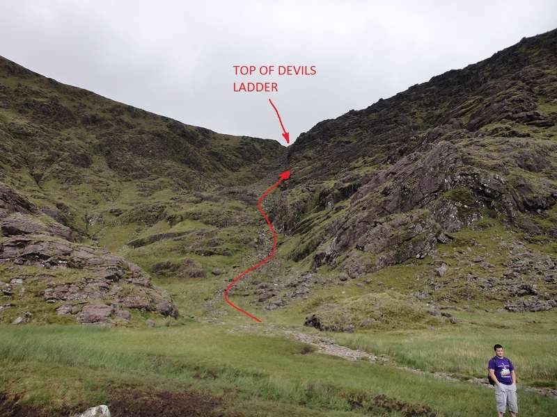
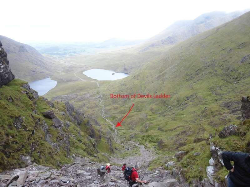
    took me 1 hour from Carpark to Bottom of devils ladder.
    1 hour to get to top of devils ladder
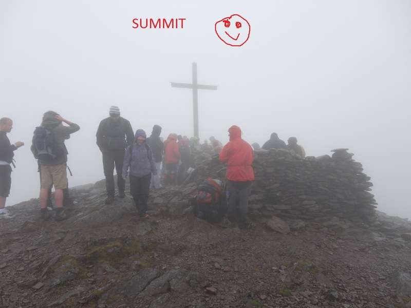
    45 minutes from top of devils ladder to summit
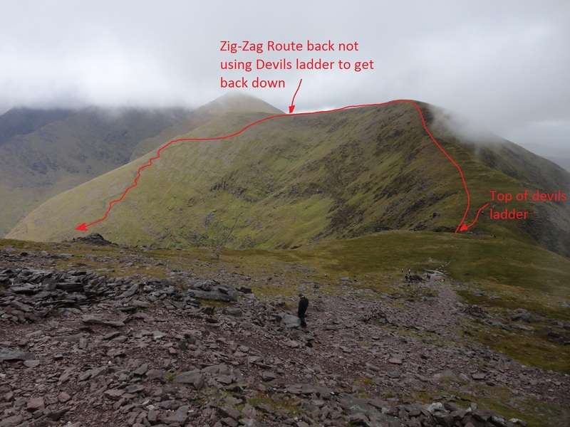
    30 minutes from summit to top of devils ladder
    1:15 down the zig-zag route
    1 hour deom bottom to back to carpark.

    With plenty of breaks inbetween.

    dsc00239a.jpg

    dsc00270un.jpg

    dsc00289gk.jpg

    dsc00302de.jpg


  • Registered Users Posts: 2,266 ✭✭✭mattser


    Well done Wolfman, and great photos too.


  • Advertisement
  • Closed Accounts Posts: 4,930 ✭✭✭duckysauce


    hi anyone have a gpx route up/down via the zig-zag route?

    cheers


  • Registered Users, Registered Users 2 Posts: 2,872 ✭✭✭sparrowcar


    duckysauce wrote: »
    hi anyone have a gpx route up/down via the zig-zag route?

    cheers

    I don't have one sorry.

    BOTOH if you are concerned about missing the start of the path then don't be. It's very hard to miss and there is a small cairn to point it out.


  • Posts: 0 [Deleted User]


    sparrowcar wrote: »
    BOTOH if you are concerned about missing the start of the path then don't be. It's very hard to miss and there is a small cairn to point it out.

    Have to say that I have been up and down the Eastern Reeks many times and I have sailed past the path a few times.

    Not that I would even consider using it! ;)

    I think it's a bit like the Heavenly Gates, once you find it once it's easy enough to spot afterwards, but finding it the first time in mist and rain and poor visibility and if there is any disorientation...not sure it's a "certainty". Then again, I guess that goes back to the question of being comfortable in those conditions first and foremost.


  • Registered Users, Registered Users 2 Posts: 2,872 ✭✭✭sparrowcar


    Have to say that I have been up and down the Eastern Reeks many times and I have sailed past the path a few times.

    Not that I would even consider using it! ;)

    I think it's a bit like the Heavenly Gates, once you find it once it's easy enough to spot afterwards, but finding it the first time in mist and rain and poor visibility and if there is any disorientation...not sure it's a "certainty". Then again, I guess that goes back to the question of being comfortable in those conditions first and foremost.

    I agree about the heavenly gates alright but the zig zags is a very obvious track as its a different colour than the rest of the mountain side and stands out a fair bit. It could be a confidence thing alright.

    Maybe I am just more observant than others ;)


  • Posts: 0 [Deleted User]


    sparrowcar wrote: »
    I agree about the heavenly gates alright but the zig zags is a very obvious track as its a different colour than the rest of the mountain side and stands out a fair bit.

    Ohhh at certain times of the year. I have seen it churned up and stick out like a sore thumb. But have also seen it after a bit of growth and a rest and it's amazing how quickly it fades again. Haven't been up there in a few weeks mind, or indeed taken any notice of it for a while.


  • Advertisement
Advertisement