Advertisement
If you have a new account but are having problems posting or verifying your account, please email us on hello@boards.ie for help. Thanks :)
Hello all! Please ensure that you are posting a new thread or question in the appropriate forum. The Feedback forum is overwhelmed with questions that are having to be moved elsewhere. If you need help to verify your account contact hello@boards.ie
Malin Head the windiest station in Ireland - but is it really?
Options
-
21-01-2012 10:22pm#1A few years ago I was messing around on google Streetview and was looking for the various ME stations around the country. Malin Head is as visible as they come, right up against the road.

What struck me then was the height of the anemometer tower, and I reckoned it must be well over the standard 10 metres that all the others are at. I reckoned I was just imagining it, but I recently saw two different Met Eireann references to windspeeds from there, both noting that the anemometer is at 18 metres above ground level. This one was about the 1976 storm, and there was another referring to the record set on January 3rd.
Malin Head is reported to be the windiest station in Ireland, but this 8 metre difference is a significant problem when it comes to comparing this station to others. In general, wind speed increases with height, especially in the lowest tens of metres near the ground, where surface frictional effects are greatest. The official guidlelines state an anemometer height of 10 metres above the ground.
In general, when comparing windspeeds at different heights, the percentage increase in speed with increase in height above 10 metres is
10 m Standard
15 m +5%
20 m +8%
25 m +11%
30 m +13%
35 m +14%
40 m +15%
So we can see that even going from 10 to 15 metres there is a 5% increase in speed, and from 10 to 18 metres it would be around 7%. These figures are very dependant on the type of terrain and airmass though, with the greatest effect occuring in stable conditions over a populated area. Malin head is a peninsula, with undulating terrain which would add some effect to the windshear above.
In climatological terms, I reckon it is flawed to state Malin Head as the windiest station in Ireland when in reality we are not comparing like with like, and over the broad airmass types we would get in a climatological period, if measured windspeeds are higher (by around 7%?) then it may not be due to anything more than station setup.
Does anyone know why it's at 18 metres?1
Comments
-
In the January Weather Bulletins on the back page are "Notes on the tables"Wind speeds refer to the wind at an effective height of 10 metres above the ground with the exception of Malin Head, where the height is 18 metres.
So I've always known it to be 18 metres and I've no idea why it is at that height! and I agree with your sentiments0 -
Possible reasons.
1. The local terrain is a tad higher to the south and south west and highly exposed W to N to E. Consequently SW winds would have been anomalously reduced by that terrain and some compensation may have been made for that anomaly. Valentia was always located further from high terrain as is Belmullet. See the same area with terrain turned on Here.
2. IIRC that mast doubled up as a HF Ship to Shore comms mast in their coastguard days and may have been a back up HF comms link to The Phoenix Park HQ for their hourly or 3 hourly reports in the days when the local phone system really was not up to much...probably till 1985. Where ELSE can one mount an anenometer on a mast without causing anomalous readings in some direction. ( Correction it did not , that is nearby)>http://www.malinheadcoastguardradio.com/
3. Maybe it was on the other lower mast and had to be 2m clear of that as it was not removed.
4. Maybe the other lower mast is as high as it is to compensate for a move 'down' from the old radio station which is higher up and to its west.
5. Maybe the locals messed with it coming home pished from the pub.
Maybe all those.") 0
0 -
Sponge Bob wrote: »Possible reasons.
1. The local terrain is a tad higher to the south and south west and highly exposed W to N to E. Consequently SW winds would have been anomalously reduced by that terrain and some compensation may have been made for that anomaly. Valentia was always located further from high terrain as is Belmullet. See the same area with terrain turned on Here.
Raising it 8 metres is not going to negate any effect from hills nearly a kilometer away. We're talking about the surface layer here, the bottom few metres, where the windshear is greatest. Nearly doubling the anemometer height above the ground will show its effects here.
I've asked Met Eireann about it and am waiting to hear back from them.0 -
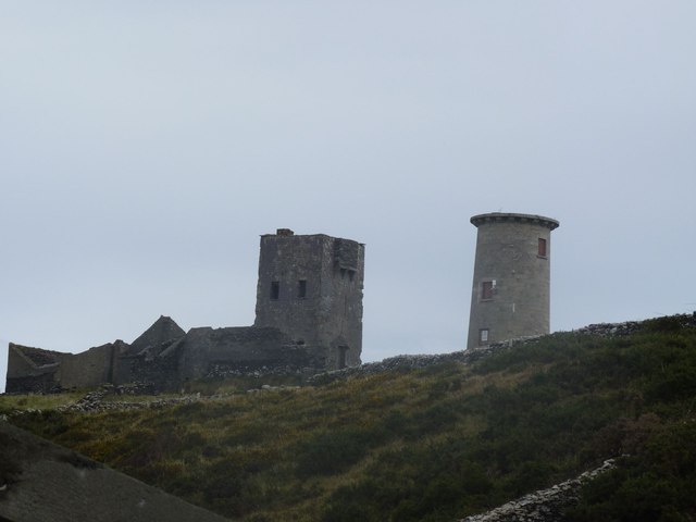
Just looking at the picture, I wonder is anemometer placed at that height to counteract any turbulence or eddies that might be created not only by the obviously rough and uneven terrain (as already mentioned) but also from those buildings nearby? Those buildings also look to be on a higher part of the hill as well. Another possibility is that it could be to negate any excess windspeed that can occur when wind travels up a hill or slope, as the station at Malin would seem to be on one just going by the image. A couple of theories anyways.0
-
Deep Easterly wrote: »Another possibility is that it could be to negate any excess windspeed that can occur when wind travels up a hill or slope, as the station at Malin would seem to be on one just going by the image.
I think I've been told that this is something to do with it. So to prevent higher speeds from the seaward side, it records higher from the land side....0 -
Advertisement
-
A few years ago I was messing around on google Streetview and was looking for the various ME stations around the country. Malin Head is as visible as they come, right up against the road.
What struck me then was the height of the anemometer tower, and I reckoned it must be well over the standard 10 metres that all the others are at. I reckoned I was just imagining it, but I recently saw two different Met Eireann references to windspeeds from there, both noting that the anemometer is at 18 metres above ground level. This one was about the 1976 storm, and there was another referring to the record set on January 3rd.
Malin Head is reported to be the windiest station in Ireland, but this 8 metre difference is a significant problem when it comes to comparing this station to others. In general, wind speed increases with height, especially in the lowest tens of metres near the ground, where surface frictional effects are greatest. The official guidlelines state an anemometer height of 10 metres above the ground.
In general, when comparing windspeeds at different heights, the percentage increase in speed with increase in height above 10 metres is
10 m Standard
15 m +5%
20 m +8%
25 m +11%
30 m +13%
35 m +14%
40 m +15%
So we can see that even going from 10 to 15 metres there is a 5% increase in speed, and from 10 to 18 metres it would be around 7%. These figures are very dependant on the type of terrain and airmass though, with the greatest effect occuring in stable conditions over a populated area. Malin head is a peninsula, with undulating terrain which would add some effect to the windshear above.
In climatological terms, I reckon it is flawed to state Malin Head as the windiest station in Ireland when in reality we are not comparing like with like, and over the broad airmass types we would get in a climatological period, if measured windspeeds are higher (by around 7%?) then it may not be due to anything more than station setup.
Does anyone know why it's at 18 metres?
hmmm it's an interesting point. Is it comparing like with like given it's exposure and geographical considerations? If it is part of a windward slope then the direct unhindered force of wind over the sea would be forced upward at any rate toward the station mast. From that point of view it's not taking a direct hit from the winds which if off the Atlantic are being forced upward. Maybe this is the reason it is higher then normal? Or perhaps it's to be above the height of the landmass to the East, South? I am not familiar with the area but undoubtedly it must be down to local geographical considerations.
It could just be the gradient of the slope. You would have to have a good idea of the locality.0 -
The Met stations in Blacksod Malin and Roches were called Telegraphic Stations, not Observatories. Telegraphic stations date back to the Martello towers of the 1800 era and some were then taken over by Lloyds of London and were ship to shore communications systems where Lloyds could warn of ships approaching ports like Liverpool etc and message out to the ships in the pre radio days using Semaphore flags.
The original shipping forecast was a flag hoisted on certain of these stations which gave a gale warning....or not.
Telegraphs were added in the period 1850-1860 but ship to shore and land based comms were previously Semaphores.
Telegraph and Weather became symbiotic. Highly so. This is understandable in a Britain that was mercantile and sea facing.
http://distantwriting.co.uk/companiesandweather.aspxA surprising number of people connected with the telegraph were members of the Meteorological Society by 1862; William Andrews of the United Kingdom company, C T Bright of the Magnetic company, E B Bright of the Magnetic, Samuel Canning of the Atlantic Telegraph, Edwin Clark of the Electric company, Latimer Clark of the Electric, R S Culley of the Electric, J S Fourdrinier of the Electric, Nathaniel Holmes of the Universal company, R S Newall, the submarine cable maker, Julius Reuter, J O N Rutter, who introduced the electric burglar and fire alarm, S W Silver, the maker of cables and insulators, and C V Walker, the telegraphic superintendent of the South Eastern railway who had been a member from its foundation.
At the Great Exhibition of 1851, inspired by this new interest in meteorology, the Electric Telegraph Company used its circuits to collect the wind direction, the state of the weather and the state the barometer from sixty-four places about the country at the Crystal Palace at 9am each day between August 8 and October 11, 1851 and recorded them on a great meteorological chart with moveable symbols and arrows displayed on its stand. The Company also printed its Weather Map every day on a press by the chart and sold them to visitors for 1d a copy.
Then in 1859 Admiral Robert Fitzroy introduced a system of Meteorological Telegrams. Weather readings from the coasts along an area bounded by Nairn, Helder and Skuddernaes in the north and north-east, by L’Orient and Rochefort in the south, and by Galway, Valentia and Cape Clear ( yes a signal tower) in the west were collected twice a day and telegraphed to a Meteorological Office in London. Here they were inscribed on maps and weather patterns determined. This enabled a day or even two days notice before dangerous winds reached the British seas and ports, as Fitzroy declared ‘forecasting the weather’.
Each of the fifteen international coastal reporting stations was equipped with a standard barometer, a wind vane, a dry thermometer and a wet thermometer. At 8am and 1pm every day the station master would transmit the readings of these instruments to London reduced to six groups of five figures. This compressed data included current air pressure, dry temperature, wet temperature, direction of wind, force of wind, cloud, character of weather and sea disturbance, as well as changes since the last report in the direction of wind, highest or lowest temperatures and air pressures.
As the system developed by 1860 ‘The Times’ newspaper was publishing daily weather forecasts, and by 1861 the Meteorological Department of the Board of Trade was co-ordinating the world’s first weather service.
The 6 groups of 5 figures synoptic reports were themselves based on the Semaphore system in use already, the Marryat 'Universal Code of Signals'
Blacksod was not in Blacksod but west of Fallmore on the west coast of the peninsula here
Malin was here
Roches is shown in better detail here. http://maps.osi.ie/publicviewer/#V1,582581,560174,7,9
Naturally Semaphore and ship to shore comms work better where one has a high point.
As part of the Lloyds services to shipping they started to take weather measurements at some stage in the 1800s, certainly in some cases by 1860 when Admiral Fitzroy the founder of the UK Met decided to do shipping forecasts, and the formal Met service when that was later set up in the UK then co located with the Signalling personnel owing to the presence of the Telegraph to get the reports out to London.
Marconi set up 2 ship to shore radio stations, at Brow Head near Mizen and in Malin ( photo above) which obviated the need for the Lloyds Semaphore Signalling Stations over time.
I reckon that did for the Blacksod Telegraphic station and the Met station moved to the Lighthouse to the east thereafter.
But assume that any wind readings taken at Blacksod and Malin pre 1900 were quite probably taken at a greater height than would be the case at todays Malin and Belmullet Met stations.0 -
hmmm it's an interesting point. Is it comparing like with like given it's exposure and geographical considerations? If it is part of a windward slope then the direct unhindered force of wind over the sea would be forced upward at any rate toward the station mast. From that point of view it's not taking a direct hit from the winds which if off the Atlantic are being forced upward. Maybe this is the reason it is higher then normal? Or perhaps it's to be above the height of the landmass to the East, South? I am not familiar with the area but undoubtedly it must be down to local geographical considerations.
It could just be the gradient of the slope. You would have to have a good idea of the locality.
Well to the east and north is just sea - the station's only around 50 m from the beach. To the south the land is fairly flat, and the only heigher terrain is the 174 m Cahirr's Hill to the southeast and the 109 m Crockafallagh around 1 km to the southwest. Here's a relief map of the area, centred on the station itself, which is on the bend in the road at Bulbinbeg.
It's pretty clear that the extra 8 metres is not going to negate any effects from terrain. The only thing I can think of is what Deep Easterly said about those houses nextdoor, a few metres to its southeast, but the fact that they are the only buildings in the area, with sea the other side of them and all around it to the north would mean that any winds coming from anywhere from northerly to easterly would then be measured erroneously high. The buildings will only have an effect on southeasterly winds, so it seems strange that they would sacrifice all other winds just to correct for one direction.
Here's another map showing the buildings in the area. The cross marks the building with the mast. No other obstacles nearby.
I suppose we'll have to wait for the reply from ME to settle this one.0 -
Section 5.9.2 right this way ---> http://www.wmo.int/pages/prog/www/IMOP/publications/CIMO-Guide/CIMO%20Guide%207th%20Edition,%202008/Part%20I/Chapter%205.pdf0
-
Interesting posts here, long time lurker etc...
However to answer the questions, the tower is at 18 metres to negate local terrain affects, particularly those to the West and Northwest. When the wind is westerly eddies are formed to the east of North town. It also helps to avoid friction etc from the house to the south and southeast at Slieveban.
To state that Malin Head is not the windiest place is Ireland is erroneous, the records speak for themselves, you just have to experience the sheer power of a full blown Atlantic storms. One thing that does not seem to be considered here is the stations heigh above sea level and its position is actually quite close to water level, cant remember exactly but maybe only 15 metres above sea level, if memory serves. It should also hold the all Ireland record, but unfortunately the needle at the station stuck at 113mph during Debbie, a piece of info often left out, local and station estimates had it possibly 120 plus.
Interestingly enough this would not be the windiest place in Malin Head, Banbas Crown as pictured is much more exposed. So pre 1902 wind data at Malin Head would have been taken at a great height (200+ feet), So is Crockalough to the Southeast. That picture was taken on the opening day of the Marconi Radio staion in January 1902. For example the roof of the building that the men are standing on was blown of during the Stephen day storm in 1998, its made of reinforced solid concrete!!
Incase anyone is wondering I lived in Ballyhillin, Malin Head for 18 years and my parents continue to do so, its a mile further to the northwest of the station and underneath Banbas Crown as pictured. My grandfather worked at the Station just after it was built in the 1950's.0 -
Advertisement
-
Couple of Q's
Where was the station located when taken over by Met Eireann in the 1930s and between then and the 1950s when the current station was built???
When was the semaphore telegraphy system finally abandoned, radios were only installed in large ships in 1902 by and large.
Who ran the semaphore system after 1870, was it always Lloyds of London? The semaphore flags appear to be attached to a mast behind the Marconi station in that photo above. Got the answer to that here. Lloyds and Marconi handed over all the signalling to the Post Office in late 1909.0 -
I hope this doesn't sound like a history lesson, but here goes.
To answer your questions firstly the station, if you wish to call it that was located in a small hut exactly were the masts are currently located. From the 1920's to 1955 a local family the Farrens were contracted to provide at least one weather report a day, this was done by Ali Farren. His descendants still run Ireland's most northerly pub. The readings were telephoned to Dublin including wind speed/direction air ground temps barometrics and prevailing sea conditions.
On 3rd June 1944, all the reading from Malin Head were rechecked by Ali Farren and by telephone from Dublin at least 3 times during the day, which at the time was strange, and I believed further queries were made during the following 24 hours. I think we all know what happened next.....But whats no often mentioned is that small hut also had an radio direction finder which enabled allied aircraft to find their bearings!
Going back to the "Tower" as its locally known, this has been a site of lookout and occupation since the Napoleonic wars. The first Signal tower was built there in 1805, and the current derelict building build in 1884, hence weather reports from Malin Head commenced at this time.
After tests along the north coast in coleraine and Rathlin, all the equipment was moved to Malin Head in 1901 and the station opened at Altnadarrow in January 1902. Thus this was the location of both Met records and the wireless station. It was connected by telegraph to the local post office which was 3 miles away. The post office took over the running in 1909, in 1913 a new building was constructed at the crossroads inn. During the time of the WW1, the Enniskillen fusiliers were stationed at the new coastguard station. From here till 1922 records etc are scant, and the British destroyed alot of records, and actually a number of local farmhouses were refurbished when the British departed the tower and semaphore ceased as comms were readily available with Inishtrahull and other coastal stations. The new Coastguard station is about a mile and a half from the tower. During WW2 this Coastguard station was protected by the Irish Army, (but British agents were on hand for censorship purposes) and one anecdotal piece of evidence is that this location was wired with explosives to blow up, if it was to come into German hands. The Tower was not in use again until WW2 when the Irish coast watch consisting of local men (eg my great grand uncle) kept a note of passing planes and shipping.
So prior to 1922, all weather data semaphore communications etc with ships at sea and Inishtrahull island were carried out by the British and at the Tower, to give its correct name its Altnadarrow, but around the 1960's local tourist agencies tagged the name Banbas Crown, and it has stuck ever since.
As for the Met station, The Irish department of transport and power constructed the present building in 1955, and The Irish Meteorological service began running it. And I stand corrected in my earlier post I said it was 15 metres above sea level its actually 22 metres. The location of the met station was always a surprise as its on the sheltered side of the headland, ie Altnadarrow is certainly much more exposed, and certainly much windier, its also 200 feet above sea level.
The attached OS map shows the original and new locations of the weather and radio data at Malin Head.
http://www.coastalradio.org.uk/irishcg/malinhead/EJMvoice.wav click here for Malin Head doing a radio check with St. Johns Newfoundland. A radio check by Finbarr o' Connor who retired in 2009, a true gent.
Unfortunately the Met station was was automated on the 1st January 2010, which was IMO a huge mistake, and I wish to thanks the likes of Sean and Jim who at times I probably drove demented, I know I certainly enjoyed it!
Well it did turn into a history lesson, but I hope you enjoy it.0


Advertisement