Advertisement
If you have a new account but are having problems posting or verifying your account, please email us on hello@boards.ie for help. Thanks :)
Hello all! Please ensure that you are posting a new thread or question in the appropriate forum. The Feedback forum is overwhelmed with questions that are having to be moved elsewhere. If you need help to verify your account contact hello@boards.ie
Hi all! We have been experiencing an issue on site where threads have been missing the latest postings. The platform host Vanilla are working on this issue. A workaround that has been used by some is to navigate back from 1 to 10+ pages to re-sync the thread and this will then show the latest posts. Thanks, Mike.
Hi there,
There is an issue with role permissions that is being worked on at the moment.
If you are having trouble with access or permissions on regional forums please post here to get access: https://www.boards.ie/discussion/2058365403/you-do-not-have-permission-for-that#latest
There is an issue with role permissions that is being worked on at the moment.
If you are having trouble with access or permissions on regional forums please post here to get access: https://www.boards.ie/discussion/2058365403/you-do-not-have-permission-for-that#latest
2020 Hurricane Season (Atlantic & East Pacific)
Comments
-
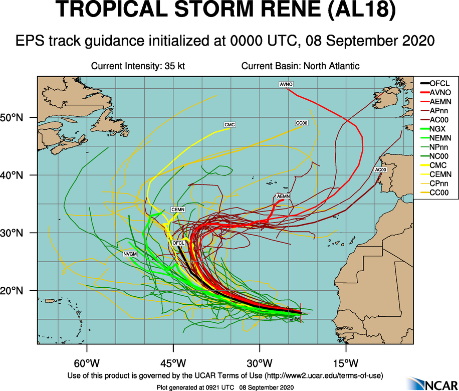
Rene is leaving the Cabo Verde islands now after bringing rare rainfall and stiff breezes overnight. It seems to want to take a similar path to Lorenzo last year, remaining east of 50W. Intensity-wise, however, it looks like it might just make around 70 knots before shear and cooler water cause it to start to weaken.
 0
0 -
They now suspect Paulette may also become a hurricane for a time, so the projected count is potentially 17/7/1.
It would be quite unusual for the pace to slow down at this traditional peak of season so the 2005 record may be under threat, but not its hurricane components, at least not until we exhaust the Greek alphabet possibly, incidentally in case you wondered about this, I happened to notice that the plan in the unlikely event that a Greek alphabet storm needs a name retirement, they won't do it, but will add the storm to the "retired storm name" list with an asterisk.
Of the six 2005 storms with Greek letter names, only two became hurricanes (Beta and Epsilon).
I don't know how many Greek letters are available, but I would propose Boards moderators to form the second overflow list, or perhaps weather forum regulars. Bsal, you're in with a shout.0 -
Both storms have struggled overnight. Rene has weakened to a tropical depression as convection never really got going after Cabo Verde. They still forecast it to restrengthen again and briefly reach 65 kts before weakening again thereafter.
Paulette is fighting increasing shear and has weakened slightly to 50 knots.Its window for strengthening in the short term has passed and it will weaken over the extra few days, but it may restrengthen to 55 kts in around 5 days.
There is still a high level of uncertainty in both forecasts.0 -
Join Date:Posts: 11891
Will be interesting to see where Paulette and Rene end up and their remnants thereafter. Could meander for quite awhile in the Atlantic and eventually dissipate. GFS shows Paulette get quite close to the US East coast but very far away to have any idea yet what will be its track and strength.
Will see if Paulette, in some shape or form. makes up to our latitudes, a lot of moving parts need to align for that to happen, the jet might be in a position to steer what is left of it towards us but that could be just a warm mass of wet air by then or something stronger if it does manage to make it this far. With things so quite at the moment something of interest to follow perhaps.
Just going by the ECM charts it looks like what remains of Paulette could be a sizable feature moving North and perhaps meeting the Jet and there looks to be much cooler Polar air moving S which could set up a steep thermal gradient to fire up the jet. All maybes and if's and very much FI .


 0
0 -
Latest discussions
PauletteTropical Storm Paulette Discussion Number 12
NWS National Hurricane Center Miami FL AL172020
500 PM AST Wed Sep 09 2020
Paulette's satellite presentation has not changed since this
morning, with the center exposed just to the south of the deepest
convection. Between this morning's ASCAT pass and the most recent
satellite classifications from TAFB and SAB, which are unchanged at
T3.0 and T3.5, respectively, the maximum wind estimate remains 50
kt. Paulette continues to move into an area of stronger
southwesterly shear, which is now estimated to be 25-30 kt, and
this shear is likely to increase further to 30-35 kt within the
next 24 hours. As a result, Paulette is expected to begin
weakening by Thursday, and the NHC forecast is embedded among the
tightly clustered intensity guidance during the first 2-3 days.
The shear is expected to relax gradually from 48 hours and beyond
and turn out of the southeast, which should allow for some
restrengthening on days 3 through 5 when shear magnitudes could go
as low as 10 kt. The HWRF and COAMPS-TC models in particular take
full advantage of this environment and bring Paulette to hurricane
intensity by day 4. The updated NHC intensity forecast is not
nearly this aggressive, but it does indicate a little more
strengthening at the end of the forecast period than has been shown
in previous forecasts, lying closest to the statistical-dynamical
guidance. Model environmental trends will be monitored, and
additional intensity adjustments at the end of the forecast period
will be made accordingly in subsequent forecasts.
Paulette remains on a west-northwestward course (295/9 kt), located
to the south of low- to mid-level ridging which extends across the
central and western Atlantic. The track models suggest that when
the cyclone weakens in a day or two, lower-level winds could steer
the cyclone westward for a short time. However, a combination of
the ridge weakening and Paulette's expected re-strengthening should
cause the cyclone to turn northwestward in 2-3 days and maintain
that trajectory through the end of the forecast period. The only
significant change from the previous forecast is that the 5-day
forecast point has been shifted westward, with the GFS, ECMWF,
HWRF, and HCCA models all lying on the left side of the guidance
envelope by that time.
FORECAST POSITIONS AND MAX WINDS
INIT 09/2100Z 20.5N 47.4W 50 KT 60 MPH
12H 10/0600Z 20.9N 48.9W 50 KT 60 MPH
24H 10/1800Z 21.4N 50.9W 45 KT 50 MPH
36H 11/0600Z 21.6N 52.7W 40 KT 45 MPH
48H 11/1800Z 22.3N 54.1W 40 KT 45 MPH
60H 12/0600Z 23.3N 55.4W 40 KT 45 MPH
72H 12/1800Z 24.8N 56.6W 45 KT 50 MPH
96H 13/1800Z 28.0N 60.5W 50 KT 60 MPH
120H 14/1800Z 30.5N 64.5W 55 KT 65 MPH
ReneTropical Storm Rene Discussion Number 11
NWS National Hurricane Center Miami FL AL182020
500 PM AST Wed Sep 09 2020
Although the cloud pattern of Rene has changed little in overall
organization since earlier today, there are some indications that
the easterly shear over the storm has diminished somewhat. Cirrus
cloud motions show that upper-level outflow is slightly more evident
over the eastern portion of the circulation, but it remains limited
over that region. The current intensity estimate remains 35 kt in
agreement with a Dvorak estimate from TAFB. Vertical shear is
predicted to be modest over Rene during the next couple of days, and
this should allow for some strengthening. The official intensity
forecast is similar to the model consensus and continues to show the
system becoming a hurricane, albeit briefly. After day 3, the
western portion of a large upper-level trough over the eastern
Atlantic is likely to impart increased shear, which should lead to
weakening.
Conventional satellite and microwave fixes show a continued
west-northwestward motion at about 285/11 kt. Rene is currently
located on the southwest side of a mid-level ridge over the eastern
Atlantic. A weakness in the ridge in the vicinity of 40W-45W
longitude should induce a turn toward the northwest and
north-northwest in 3-5 days. By the end of the forecast period,
Rene's forward progress begins to be blocked by building mid-level
heights to its north and northwest, which should cause the cyclone's
forward motion to slow down significantly. The official track
forecast has been adjusted farther to the left of the previous one,
to be closer to the latest model consensus.
FORECAST POSITIONS AND MAX WINDS
INIT 09/2100Z 18.0N 32.7W 35 KT 40 MPH
12H 10/0600Z 18.4N 34.3W 40 KT 45 MPH
24H 10/1800Z 18.9N 36.2W 45 KT 50 MPH
36H 11/0600Z 19.5N 38.1W 50 KT 60 MPH
48H 11/1800Z 20.5N 40.0W 60 KT 70 MPH
60H 12/0600Z 21.7N 42.0W 65 KT 75 MPH
72H 12/1800Z 23.5N 43.8W 60 KT 70 MPH
96H 13/1800Z 26.9N 46.0W 50 KT 60 MPH
120H 14/1800Z 28.5N 47.0W 40 KT 45 MPH0 -
Advertisement
-
GFS has been toying with the idea of a major hurricane to develop next week and impact Florida and parts of the eastern U.S., 00z run has this hitting Tampa Bay in two weeks. Of course too early to put much stock in details but the signal has been there for a while. This one would form out of a trough associated with the current wave coming out of west Africa. While that one only develops into a tropical disturbance following a path similar to Rene, at about day ten a second storm develops off to its southwest and that one heads into the Caribbean with major impacts currently depicted for Jamaica (day ten) and western Cuba (day twelve). Then it would hit west-central Florida, cross over into the Atlantic and make a second landfall near Charleston SC but heading well inland there rather than heading up the Gulf stream.
This may look considerably different in a week, but for now, a broad area of concern in the Caribbean and eastern U.S. for what looks to be the season's strongest storm.0 -
Two things have so far contributed hugely to the unusually low ratio of major hurricanes to named storms - a southward displacement of the African Easterly Jet for much of July and into August, and a very large outbreak of dust plumes from the Sahara. The former resulted in the majority of tropical waves failing to achieve the latitude required to spin up during July, when wind shear was at a record low in the Caribbean - had these waves not been displaced in this manner, it's very likely that July would have churned out a couple of major hurricanes in the same way that 2005 did. The wind shear profile was phenomenally low for the time of year, and even with the dry air over the basin, it's highly likely that waves which made it into the Caribbean during those few weeks would have been able to rapidly intensify and mix out any dry air relatively quickly.
The Caribbean island and the gulf states dodged a major bullet in having the wave train essentially "miss" the MDR during the period in which conditions were so incredibly favourable. Ironically enough, once the wave train managed to life northward, these incredibly favourable conditions dissipated and were replaced by average to unfavourable conditions, as the gigantic sinking cell over the date line finally shifted and lifted the lid on Pacific convection, thus allowing upper level winds to drift over the Atlantic and increase the shear.
@M.T, I'm interested that you seem to regard this season's lack of major hurricanes as set in stone, given that in recent years, many seasons have been back-loaded with an explosion in intense Atlantic systems occurring in late September and through October. Given how things seem to be headed, it wouldn't surprise me in the least to see those numbers change dramatically before the season is out.0 -
Latest discussions.
Paulette is looking like heading close to Bermuda as a Cat 1 on Monday.Tropical Storm Paulette Discussion Number 16
NWS National Hurricane Center Miami FL AL172020
500 PM AST Thu Sep 10 2020
Continuous bursts of deep convection have been ongoing to the north
and northeast of Paulette's center of circulation, with the cyclone
being affected by nearly 40 kt of deep-layer southwesterly shear.
The highest intensity estimates are Dvorak classifications of
T3.0/45 kt from TAFB and SAB, and that value remains the initial
intensity. The shear should reach its peak magnitude this evening,
which is likely to cause Paulette to weaken slightly during the
next 24 hours. However, gradual re-strengthening is forecast to
begin in about 36 hours, and the rate of intensification is expected
to increase in 2 to 3 days when the shear could fall to 10 kt or
less, along with a more unstable atmosphere and warmer sea surface
temperatures. Paulette is now forecast to become a hurricane by day
3 and continue to intensify through the end of the forecast period.
As was advertised in the previous forecast package, the new NHC
forecast intensities have been bumped up on days 3 through 5 and
now lie near or just below the IVCN intensity consensus and the
HCCA corrected consensus aid.
Paulette's heading over the past 6-12 hours has been toward the
west-northwest, or 300/8 kt. The cyclone's trajectory is expected
to oscillate between northwest and west-northwest for the next 4
days, being dictated by the strength of the subtropical ridge to
the north and the depth of the steering flow depending on
Paulette's intensity. The updated NHC track forecast during this
period has been nudged a bit to the north, mostly to account for an
adjustment of the initial position. The model guidance all agree
that Paulette should turn northward around the western side of a
central Atlantic high pressure area by day 5, with the expected
hurricane likely to make a tight recurvature near Bermuda. There
remains some uncertainty on exactly where that turn will occur, but
for now the NHC forecast lies between the tighter-turning ECMWF and
HCCA models and the more gradually-turning GFS and HWRF models.
Key Messages:
1. Paulette is expected to approach Bermuda as a hurricane this
weekend and make its closest approach to the island on Monday and
Tuesday. While the exact details of Paulette's track and intensity
near the island are not yet known, the risk of strong winds, storm
surge, and heavy rainfall on Bermuda continues to increase.
2. Swells produced by Paulette are expected to affect portions of
the Leeward Islands, the Greater Antilles, the Bahamas, Bermuda,
and the southeastern United States into the weekend. These swells
could cause life-threatening surf and rip current conditions.
FORECAST POSITIONS AND MAX WINDS
INIT 10/2100Z 22.1N 50.1W 45 KT 50 MPH
12H 11/0600Z 22.5N 51.5W 40 KT 45 MPH
24H 11/1800Z 23.6N 53.4W 40 KT 45 MPH
36H 12/0600Z 25.0N 55.1W 45 KT 50 MPH
48H 12/1800Z 26.6N 56.8W 45 KT 50 MPH
60H 13/0600Z 28.0N 58.9W 55 KT 65 MPH
72H 13/1800Z 29.2N 61.4W 65 KT 75 MPH
96H 14/1800Z 31.5N 65.5W 75 KT 85 MPH
120H 15/1800Z 34.5N 64.0W 80 KT 90 MPH
ReneTropical Storm Rene Discussion Number 15
NWS National Hurricane Center Miami FL AL182020
500 PM AST Thu Sep 10 2020
It appeared that the storm had become better organized this
morning, but that development trend seems to have been at least
temporarily interrupted. Rene's central features have become
rather ragged-looking, and deep convection has diminished somewhat.
It appears that the system is being disrupted a bit by easterly flow
that is undercutting the outflow layer. There is also an apparent
dearth of low-level inflow over the southern and southeastern
portions of the circulation at this time. Dvorak intensity
estimates from both TAFB and SAB remain T3.0/45 kt, so the
current intensity estimate is unchanged from the previous advisory.
Assuming that the upper-level winds will soon become a little more
conducive for strengthening, Rene is forecast to become a hurricane
by the weekend. The official intensity forecast is a little below
the latest model consensus.
Rene continues its west-northwestward movement with a motion of
near 285/10 kt. The cyclone is expected to turn northwestward and
then north-northwestward for the next few days, while moving around
the western periphery of a mid-level anticyclone. Later in the
forecast period, A mid-level high is predicted to build to the
northwest of Rene, which should slow down the cyclone's forward
progress and cause it to turn to the left. At the present time, it
appears that Rene will remain sufficiently separated from Paulette,
which is located about 800 n mi to the west, for there not to be a
significant binary interaction between the two storms. The
official track forecast remains close to the simple dynamical model
consensus, TVCN.
FORECAST POSITIONS AND MAX WINDS
INIT 10/2100Z 18.9N 36.8W 45 KT 50 MPH
12H 11/0600Z 19.4N 38.1W 50 KT 60 MPH
24H 11/1800Z 20.2N 40.1W 55 KT 65 MPH
36H 12/0600Z 21.3N 42.2W 60 KT 70 MPH
48H 12/1800Z 22.7N 44.1W 65 KT 75 MPH
60H 13/0600Z 24.3N 45.7W 65 KT 75 MPH
72H 13/1800Z 25.8N 46.7W 60 KT 70 MPH
96H 14/1800Z 27.3N 47.5W 50 KT 60 MPH
120H 15/1800Z 27.5N 49.5W 45 KT 50 MPH0 -
Latest Microwave scans.
The southwesterly shear is clearly evident in Paulette, with the convection well to the north of the low-level centre.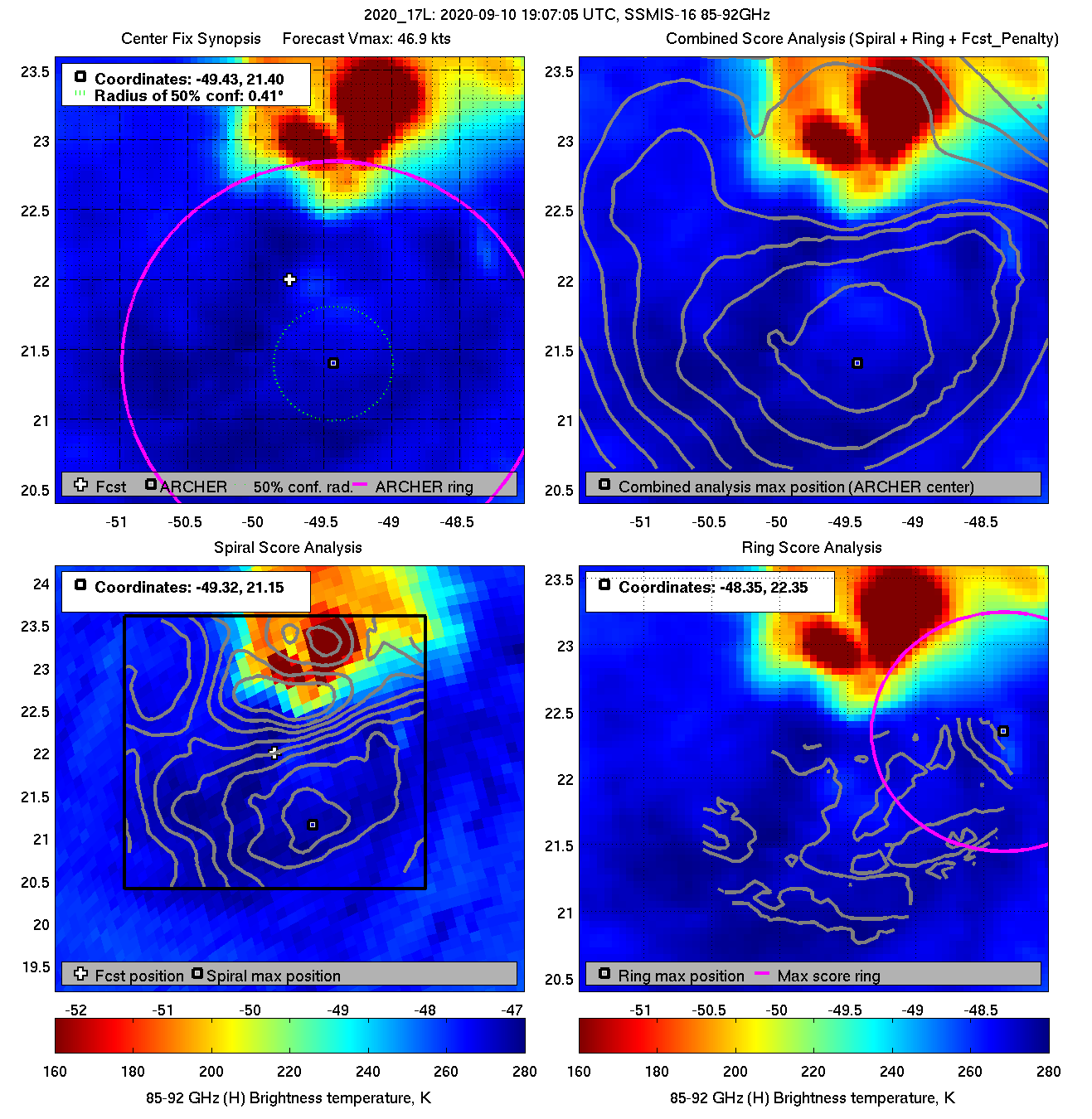
Rene has very little deep convection.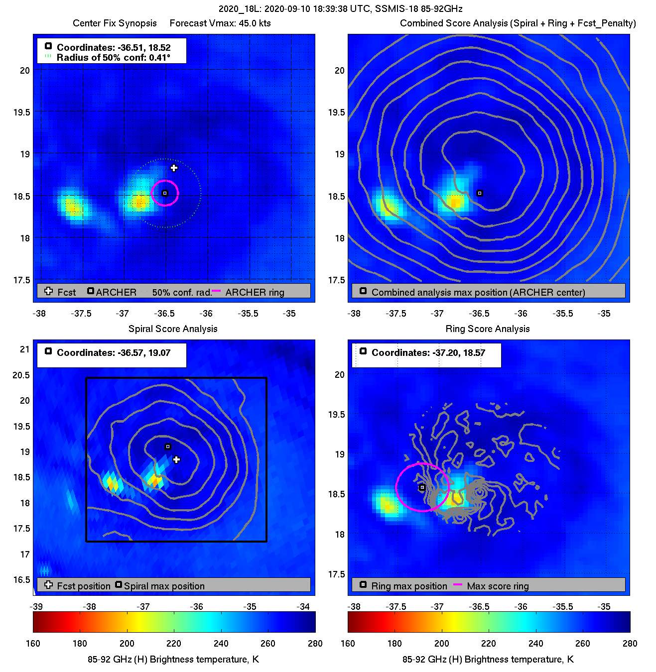
 0
0 -
Paulette is expected to be Cat1/2 (around 90 knots) as it nears Bermuda on Monday. SHIPS 12Z.Tropical Storm Paulette Discussion Number 19
NWS National Hurricane Center Miami FL AL172020
1100 AM AST Fri Sep 11 2020
Despite what is being analyzed as roughly 40 kt of deep-layer
southwesterly shear, Paulette's center is embedded beneath the
cirrus canopy of a strong convective burst to the north. Recent
microwave images do confirm, however, that the center remains
displaced from the convection. We have not yet received new
scatterometer data over Paulette, and since the structure has not
degraded from overnight, the initial intensity remains 55 kt. This
is in best agreement with the Dvorak estimate from TAFB.
Paulette appears to have turned toward the northwest (305/9 kt)
based on center fixes over the past 12 hours. A weakness in the
subtropical ridge is beginning to develop to the north of Paulette,
which should allow the cyclone to maintain a motion toward the
northwest or west-northwest during the next 3 days. After that
time, a longwave trough forecast to move across the northeastern
United States is expected to erode the ridge eastward, causing
Paulette to recurve sharply toward the north and northeast in the
vicinity of Bermuda on days 4 and 5. Except for some minor speed
differences, the track models agree on this general trajectory and
have less east-to-west spread during the recurvature phase than
they did yesterday. The GFS, ECMWF, HCCA, and Florida State
Superensemble aids all lie along the western side of the guidance
envelope at the time of recurvature, and as a result the new NHC
track has been nudged a little west of the previous prediction
during that period in deference to those normally reliable models.
The shear affecting Paulette is forecast to abate over the next 48
hours while the storm also moves over warmer ocean waters and into
a more unstable environment. Given the cyclone's hardiness in the
face of the ongoing shear, Paulette is unlikely to have problems
responding to the improving environment. Paulette is now forecast
to become a hurricane in 36 hours, which is supported by the latest
dynamical hurricane models, the superensemble aids, and the IVCN
intensity consensus. Continued strengthening is anticipated after
36 hours, with Paulette likely to reach a peak intensity in 4-5
days.
Key Messages:
1. Paulette is expected to approach Bermuda as a hurricane this
weekend and make its closest approach to the island on Monday.
While the exact details of Paulette's track and intensity near the
island are not yet known, the risk of strong winds, storm surge,
and heavy rainfall on Bermuda continues to increase.
2. Swells produced by Paulette are affecting portions of the
Leeward Islands and will continue to spread westward to the Greater
Antilles, the Bahamas, Bermuda, and the southeastern United States
into the weekend. These swells could cause life-threatening surf
and rip current conditions.
FORECAST POSITIONS AND MAX WINDS
INIT 11/1500Z 23.6N 52.2W 55 KT 65 MPH
12H 12/0000Z 24.6N 53.7W 55 KT 65 MPH
24H 12/1200Z 26.1N 55.5W 60 KT 70 MPH
36H 13/0000Z 27.6N 57.5W 65 KT 75 MPH
48H 13/1200Z 28.9N 59.9W 75 KT 85 MPH
60H 14/0000Z 30.2N 62.5W 80 KT 90 MPH
72H 14/1200Z 31.6N 64.3W 85 KT 100 MPH
96H 15/1200Z 34.5N 63.5W 90 KT 105 MPH
120H 16/1200Z 37.0N 58.0W 90 KT 105 MPH
Rene is still struggling and will do a clockwise loop over the weekend and head back westwards again next week, not far off the path Paulette is currently taking. It's currently over very low ocean heat content (SST 26.5 °C) and while it will move over warmer water, shear will also increase, so it will struggle to get above around 50 knots in the next week. SHIPS 12Z.Tropical Storm Rene Discussion Number 18
NWS National Hurricane Center Miami FL AL182020
1100 AM AST Fri Sep 11 2020
Rene lost essentially all of its deep convection over the past
several hours, however recently some new thunderstorms have
developed over the western part of the circulation. The cause of
the system's decline is not clear. One negative environmental
factor could be dry air, since the SHIPS output based on the GFS
model shows mid-level relative humidities of 50-55 percent. Using a
blend of Dvorak current intensity estimates from TAFB and SAB along
with objective ADT values from UW-CIMSS gives a rather uncertain
advisory intensity of 35 kt. Since the cyclone should remain over
waters of 26.5 deg C or warmer and the shear is not expected to
increase much during the next day or two, some re-intensification is
expected. Based on the current state of Rene, the official
intensity forecast is revised downward to show less strengthening
through 48 hr compared to the previous predictions. By the latter
part of the forecast period, increasing northwesterly shear should
result in weakening. The NHC forecast is above most of the
intensity guidance.
The latest center fixes give a slightly faster west-northwestward
motion of 290/11 kt. Rene should continue to move around the
western periphery of a mid-level anticyclone for the next couple of
days. Then, a high pressure area building to the north and
northwest of the cyclone should induce a slowing of the forward
speed and a turn toward the left. The official track forecast is
similar to the previous one and closely aligned with the NOAA
corrected consensus, HCCA, prediction.
FORECAST POSITIONS AND MAX WINDS
INIT 11/1500Z 20.3N 39.9W 35 KT 40 MPH
12H 12/0000Z 21.2N 41.5W 40 KT 45 MPH
24H 12/1200Z 22.5N 43.6W 45 KT 50 MPH
36H 13/0000Z 24.3N 45.3W 50 KT 60 MPH
48H 13/1200Z 25.9N 46.4W 50 KT 60 MPH
60H 14/0000Z 27.0N 46.7W 45 KT 50 MPH
72H 14/1200Z 27.3N 46.8W 45 KT 50 MPH
96H 15/1200Z 26.8N 47.8W 40 KT 45 MPH
120H 16/1200Z 26.8N 51.0W 35 KT 40 MPH0 -
Advertisement
-
The new invest seems to have perked up a bit today, was 30% chance yesterday, now 70%
Very close to the coast to spin up too much, but SSTs very very warm there. It could cross the keys and gather more strength in the gulf also. So much so they've issued a special update about "just" an invest.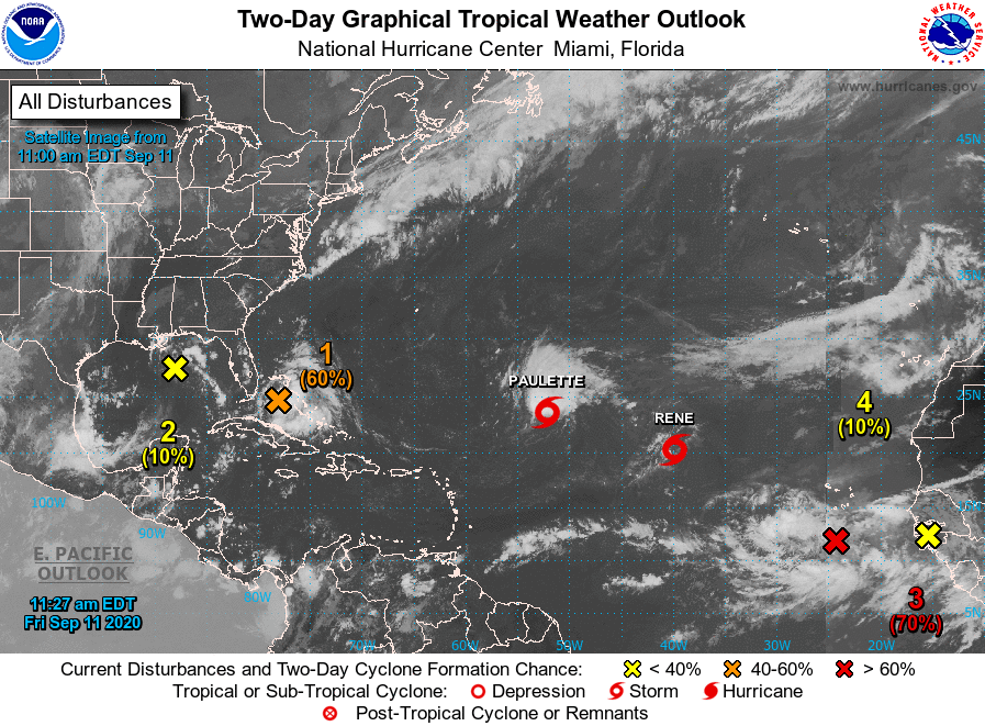 Special Tropical Weather Outlook
NWS National Hurricane Center Miami FL
1125 AM EDT Fri Sep 11 2020
For the North Atlantic...Caribbean Sea and the Gulf of Mexico:
Special Tropical Weather Outlook issued to update the discussion
and development potential for the area of disturbed weather near
the Bahamas.
The National Hurricane Center is issuing advisories on Tropical
Storm Paulette, located over the central tropical Atlantic, and on
Tropical Storm Rene, located over the eastern tropical Atlantic.
1. Updated: Shower and thunderstorm activity located over the
northwestern and central Bahamas and the adjacent waters continues
to shows signs of organization. In addition, surface observations
indicate that pressures have fallen over the area since yesterday
and, along with wind data, suggest that a broad area of low pressure
could be forming between the northwestern Bahamas and South Florida.
This system is forecast to move westward at about 10 mph, crossing
the Bahamas and Florida today and tonight and moving into the
eastern Gulf of Mexico on Saturday. The disturbance could become a
tropical depression while it is near South Florida tonight, but it
is more likely to become a tropical depression while it moves slowly
west-northwestward over the eastern Gulf of Mexico this weekend and
early next week. Regardless of development, this system is expected
to produce locally heavy rainfall over portions of the Bahamas,
South Florida, and the Florida Keys during the next couple of days,
and interests there, as well as along the northern and eastern Gulf
coast, should monitor its progress.
* Formation chance through 48 hours...medium...60 percent.
* Formation chance through 5 days...high...70 percent.
Meanwhile, the 5-day outlook is getting very busy indeed!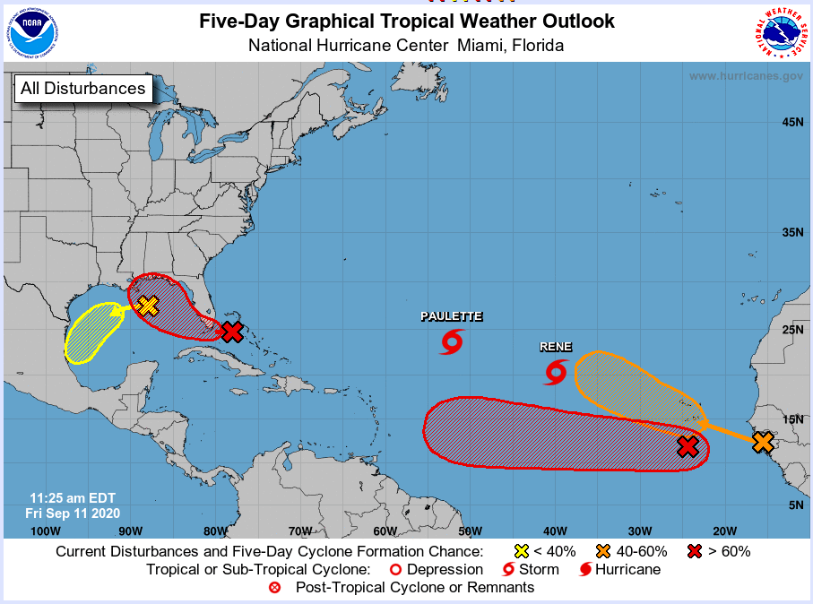 0
0 -
That system has become Tropical Depression 19.Tropical Depression Nineteen Discussion Number 1
NWS National Hurricane Center Miami FL AL192020
500 PM EDT Fri Sep 11 2020
GOES-16 1-minute satellite data show that the system near the
Bahamas that we have been monitoring for the past couple of days
has quickly organized into a tropical depression. Very deep
convection has formed near the center, and the 1-min data now shows
enough north and northwest flow to indicate that a well-defined
center is present. The initial wind speed is 30 kt in agreement
with recent ship data.
It is uncertain whether the large burst of convection over the
center will continue and cause the depression to become a tropical
storm before reaching Florida. However, since it is only a 5 kt
increase from the current intensity, it is possible that tropical
storm conditions could still occur along the southeast Florida coast
late tonight, and a tropical storm watch has been issued.
Otherwise, after the system reaches the eastern Gulf of Mexico,
steady intensification is expected through the weekend due to
expected light wind shear and very warm water. Some increase in
shear could occur over the northern Gulf of Mexico but that is
uncertain at this time. The first forecast will stay conservative
and only show a peak intensity of 60 kt in 3 to 4 days, but do not
be surprised if that is revised upward on later forecasts once
other models better initialize the depression.
An uncertain estimate of the initial motion is 285/7. Strong
ridging over the southeastern United States is expected to steer the
cyclone to the west-northwest then northwest as a mid-latitude
trough erodes the western side of the ridge over the weekend. The
forecast gets tricky after that because the bulk of the guidance
suggests the trough isn't deep enough to recurve the system, and
instead it gets left behind, moving slowly westward early next week
due to weak ridging over the southern Plains. The NHC forecast is
near the corrected-consensus guidance. The uncertainty in the
track forecast is much larger than normal after 48 hours, as small
changes in the forecast steering flow could result in this system
moving over the northern Gulf Coast faster and to the northeast of
what is shown here. As a result, the risk of seeing direct impacts
from this system extends well outside the cone of uncertainty, even
more so than usual in this case.
KEY MESSAGES:
1. Heavy rainfall is expected to produce isolated flash flooding
over portions of central and southern Florida and prolong existing
minor river flooding in the Tampa Bay area.
2. Tropical storm conditions are possible tonight along the
southeast Florida coast where a Tropical Storm Watch is in effect.
3. The system is forecast to strengthen to near hurricane intensity
by early next week as it moves across the northeastern Gulf of
Mexico. Dangerous impacts from storm surge, wind, and heavy rainfall
will be possible along the Gulf Coast from the Florida Panhandle to
southeastern Louisiana this weekend and early next week. Residents
in these areas should monitor the progress of this system and
updates to the forecast, as Storm Surge, Tropical Storm or Hurricane
watches could be issued later tonight and Saturday.
FORECAST POSITIONS AND MAX WINDS
INIT 11/2100Z 25.4N 79.0W 30 KT 35 MPH
12H 12/0600Z 25.7N 80.1W 30 KT 35 MPH
24H 12/1800Z 26.2N 81.9W 30 KT 35 MPH
36H 13/0600Z 27.3N 83.8W 35 KT 40 MPH
48H 13/1800Z 28.4N 85.2W 45 KT 50 MPH
60H 14/0600Z 29.1N 86.3W 55 KT 65 MPH
72H 14/1800Z 29.5N 87.4W 60 KT 70 MPH
96H 15/1800Z 30.0N 89.0W 60 KT 70 MPH
120H 16/1800Z 31.0N 91.0W 25 KT 30 MPH...INLAND 0
0 -
NHC covering their arses with this bit:The first forecast will stay conservative
and only show a peak intensity of 60 kt in 3 to 4 days, but do not
be surprised if that is revised upward on later forecasts once
other models better initialize the depression.
I'll stick my neck out now and say 19 is developing very quickly, to be named Sally or Teddy within 24h depending how quickly invest 95L develops, and will be a hurricane at some point within 48-72h unless it tracks anything north of directly NW over FL.0 -
 0
0 -
Meanwhile there is huge spread in both intensity and track guidance for Invest 95L, that first wave that has come off Africa. Track ranges from due west into the Caribbean to northwards into the mid-Atlantic (where Rene is now). Intensity output ranges from tropical depression to Cat 3 or 4 by day 5. It's all due to the current complex structure, with two distinct vorticity centres. Whether one breaks away westward on its own or it interacts with the other one is the question. A lot of uncertainty with all the systems out there at the moment.

 0
0 -
Join Date:Posts: 11891
I see some of the Meteorologists and Hurricane chasers in the US showing concern that now formed Tropical Storm Sally could become a stronger Hurricane then presently predicted .
Slow moving over very warm waters in the Eastern Gulf of Mexico. Landfall due Tuesday
https://twitter.com/JackSillin/status/1304842340788506624?s=20
https://twitter.com/pppapin/status/1304842078317432832?s=200 -
With Sally, the count is 18/6/1 and Sally is twenty days ahead of Stan's arrival in 2005 (earliest 18th storm).
Our next guest will be Teddy. Unless some minor candidate reaches TS status before TD 20 (recently designated as such in the tropical east-central Atlantic) then TD 20 will be Teddy. One of the numbered TDs earlier in the season did not reach TS intensity which is why TD20 could be the 19th named storm, as I teddy-us-ly mentioned earlier, Teddy will have to be compared with the 2005 interloper Azores hurricane between Stan and Tammy. Whether wikipedia recognizes that instantly or has to be told remains to be seen.
If Sally becomes a non-major hurricane and Paulette a major, and Teddy both, then the count could then reach 19/8/3. Other possibilities with Teddy only a tropical storm and none or some of the above would include 19/6/1, 19/7/1, 19/7/2, 19/8/1 or 19/8/2.
Azores and Tammy (2005) were born right after Stan around Oct 3-4 2005, so this 20-day gap will narrow over time. The GFS has perhaps one later TS candidate on display, to the west of what would become Hurricane Teddy when that's near Bermuda. But the way this season is going, a few other minor candidates could graduate too. By late September we may still be ahead of 2005 but only by a week to ten days and then if nothing materializes after Teddy, we could fall behind 2005 after October 4th.
After Teddy it's to be Vicky and Wilfred, names obviously never used before and in the case of Wilfred, a possible Gilbert (1988) to be seen but once. Gilbert is not much recalled but had a very low central pressure southwest of Jamaica while moving west.
Odds on reaching the Greek alphabet are far from certain, but I would set them at 70% with breaking 2005 total of 28 named storms maybe a 20% possibility, that season had no quit in it going to the end with three IIRC in December and one that even went past New Years. We will very likely move past 1933 (20 "named" although not actually named, 11 of these became hurricanes) into second place.
If one or two more of these become majors and hit land, the season will gain some street creds, right now it's a sort of 2005 mini-me or a three dressed up as a nine.0 -
For all the named Atlantic storms so far (18 versus the average of 7.0 for this point of the season) the total ACE is still only average (54.3 v 53.9). With the exception of Laura, all other systems have been very anemic, with 11 of them failing to get above 50 knots and only Laura getting above 75 knots. Only Laura has produced anything of note on satellite (a clear eye). We are still well behind on the Hurricane Days (6.25 v 11.0), Major Hurricanes (1 vs 1.5) and Major Hurricane Days (1.0 vs 3.5).

Globally we are also well below average, due to a very quiet Pacific. The global Named/Hurricanes/Major Hurricanes/Total ACE numbers are 42/17/7/189.6 versus the average of 36.5/19.4/9.5/308.3. 0
0 -
Bermuda port webcam here when the hurricane hits
Port Bermuda Webcam - Cruise Ship Web Cam at the Royal Naval Dockyard in Bermuda
https://www.portbermudawebcam.com/0 -
Looks like Sally will test New Orleans' flood defences.
https://twitter.com/NHC_Atlantic/status/13051638386024448010 -
Advertisement
-
Join Date:Posts: 11891
From the NHC 'Unfortunately, confidence is increasing that
Sally's expected slow forward speed near the Gulf Coast will
exacerbate the storm surge and heavy rainfall threats'

NHC
KEY MESSAGES:
1. An extremely dangerous and life-threatening storm surge is now
expected, and a Storm Surge Warning is in effect for areas outside
the southeastern Louisiana Hurricane and Storm Damage Risk Reduction
System from Port Fourchon, Louisiana to the Mississippi/Alabama
border. Residents in these areas should follow any advice given by
local officials.
2. Hurricane conditions are expected by late Monday from Grand
Isle, Louisiana to Ocean Springs, Mississippi, including
Metropolitan New Orleans, with tropical storm conditions likely by
Monday. Preparations should be rushed to completion in those areas.
3. Sally is expected to produce flash flooding across southwest and
central Florida and prolong existing minor river flooding across
west-central Florida through Monday. Widespread significant flash
flooding and minor to isolated major river flooding is likely across
portions of the central Gulf Coast Monday through the middle of the
week, with flooding impacts spreading farther into the Southeast in
the middle to late parts of the week.
FORECAST POSITIONS AND MAX WINDS
INIT 13/1500Z 27.5N 84.9W 50 KT 60 MPH
12H 14/0000Z 28.0N 86.6W 55 KT 65 MPH
24H 14/1200Z 28.5N 88.2W 65 KT 75 MPH
36H 15/0000Z 28.9N 89.4W 80 KT 90 MPH
48H 15/1200Z 29.7N 90.2W 65 KT 75 MPH...INLAND
60H 16/0000Z 30.3N 90.5W 50 KT 60 MPH...INLAND
72H 16/1200Z 31.5N 90.3W 35 KT 40 MPH...INLAND
96H 17/1200Z 33.6N 88.3W 25 KT 30 MPH...INLAND0 -
Sally is following a track similar to the damaging hurricane of 1818 in that region. Camille, Katrina and various others came in more from the south than the southeast.
Here's an updated blogpost I made elsewhere clarifying or correcting some of the information about comparative storm numbers and dates.
This (currently T.D. 20) would be Teddy unless that other invest (to its northeast) makes it to TS faster, in which case that one will be Teddy and this T.D. 20 will be Vicky. After that comes Wilfred somewhere some time, and on to the Greek alphabet.
Sally was 20 days earlier than Stan (2005), the former earliest 18th storm on record.
In 2005, after the season ended, an un-named storm was inserted between Stan and Tammy in the list, namely the "Azores Subtropical Storm." That was born Oct 4 and Tammy on Oct 5. So Teddy (whichever wave becomes himself) will have to be compared to the Azores STS for record timing, and Vicky to Tammy, Wilfred to Vince (formed Oct 8, 2005), then Alpha if we get that far to Wilma (reached TS status Oct 17, 2005), which could set up the confusing situation that this year's Alpha will be not the earliest 22nd named storm but the earliest Greek letter storm (if it were to form between the dates of Wilma, now bumped to 22nd, and Alpha (23rd named storm) in 2005 which formed Oct 22nd). An Alpha forming Oct 18 to Oct 21 would create that dichotomy. This year's Beta will need to form ahead of 2005 Alpha before Oct 22nd to become earliest 23rd named storm.
The other benchmarks for formation are ... this year's Gamma will need to be ahead of Oct 27 2005 Beta for 24th named storm, this year's Delta will be compared with Nov 14 2005 Gamma for 25th named storm, this year's Epsilon with Nov 22 2005 Delta for 26th named storm, this year's Zeta with Nov 29 2005 Epsilon for 27th named storm, and this year's Eta with Dec 30 2005 Zeta for 28th. If we get to Eta this year (28th named), we will tie 2005 for total named storms. The Greek alphabet then goes Theta, Iota, Kappa, Lambda ... and some more but I think that has to be about the limit. Otherwise it might be famous Accuweather forecasters for Tropical Storm Abrams, Hurricane (of course) Bastardi and so on and so forth. But there are 13 more Greek letters after lambda, I think Hurricane Omicron would be worth moving up to get it in there. (Oh my God, it's Omicron) ... Hurricane Omega -- you don't want that hitting your town. There could be a Mu and a Nu on the go at the same time -- ultra confusing.
Whether the media or other parties pick up on this or not remains to be seen (I would expect the NWS to issue corrective reports if the date comparisons fail to take the 2005 change into account).
My guess is that we will reach the Greek alphabet stage but we might not go six letters in as they did in 2005, with all the very late activity in mid Nov and even Dec 2005 adding four more then.
More Greek trivia, only Beta and Epsilon (2 and 5) were hurricanes in 2005, so there is still room for the first Hurricane(s) Alpha, Gamma, Delta, Zeta and all the rest.0 -
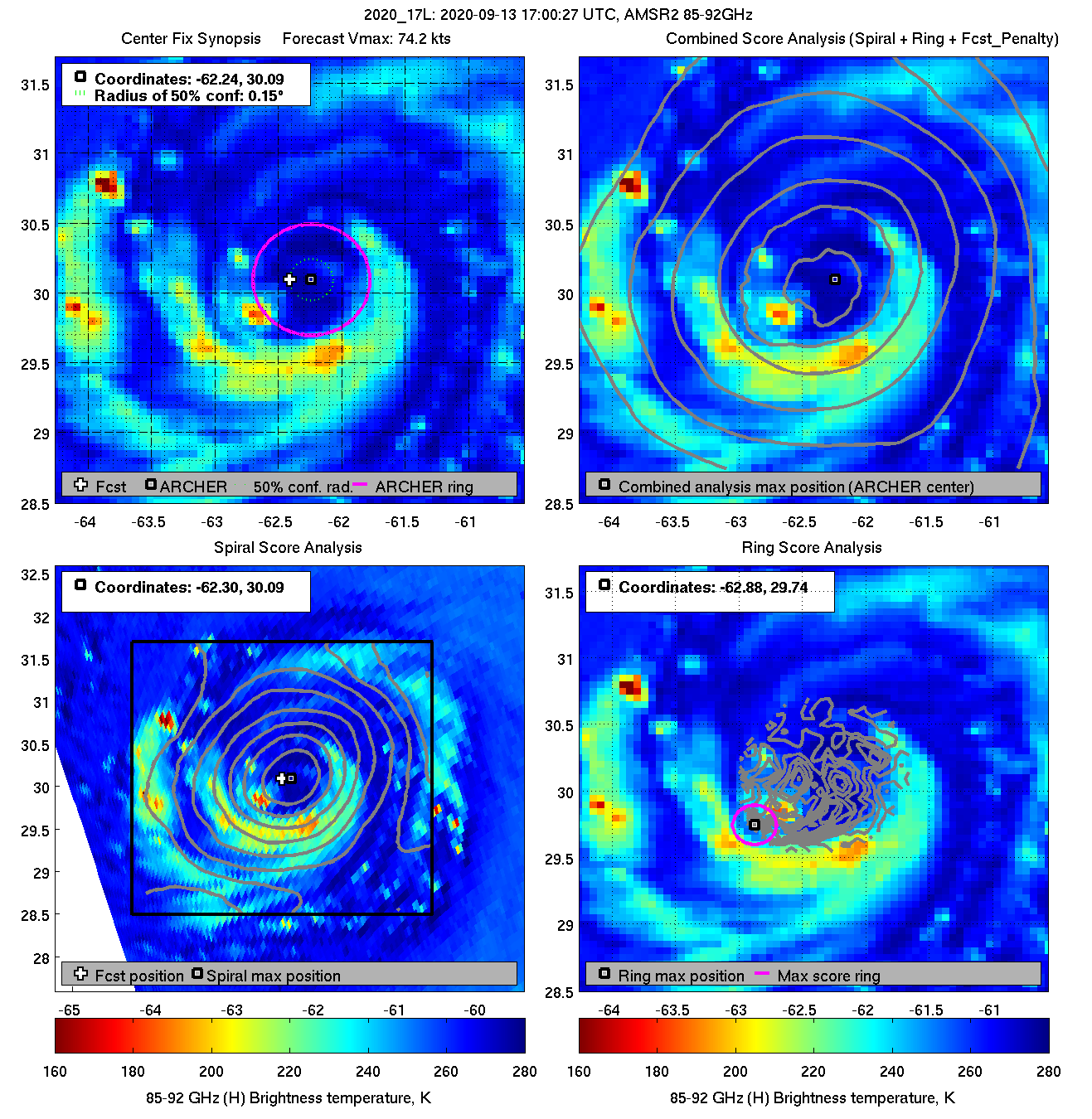
Paulette has finally formed a closed low-level ring, as seen in the 37 GHz. On the 85-92 GHz, deep convection is shown on the southern half only. Max recon SFMR winds did not top 64 knots today and were lower this evening, but the NHC has still upped the intensity to 75 knots in the latest discussion now. They are basing it on flight level winds of 82 knots, however these were shown no to be filtering down to the surface earlier. Seems a little high for now but they always err on the high side as storms approach land.
 0
0 -
Bermuda radar. The outer rainband is just under 50 km off the the southeast now.
http://weather.bm/tools/graphics.asp?name=250KM%20SRI&user=
 0
0 -
-
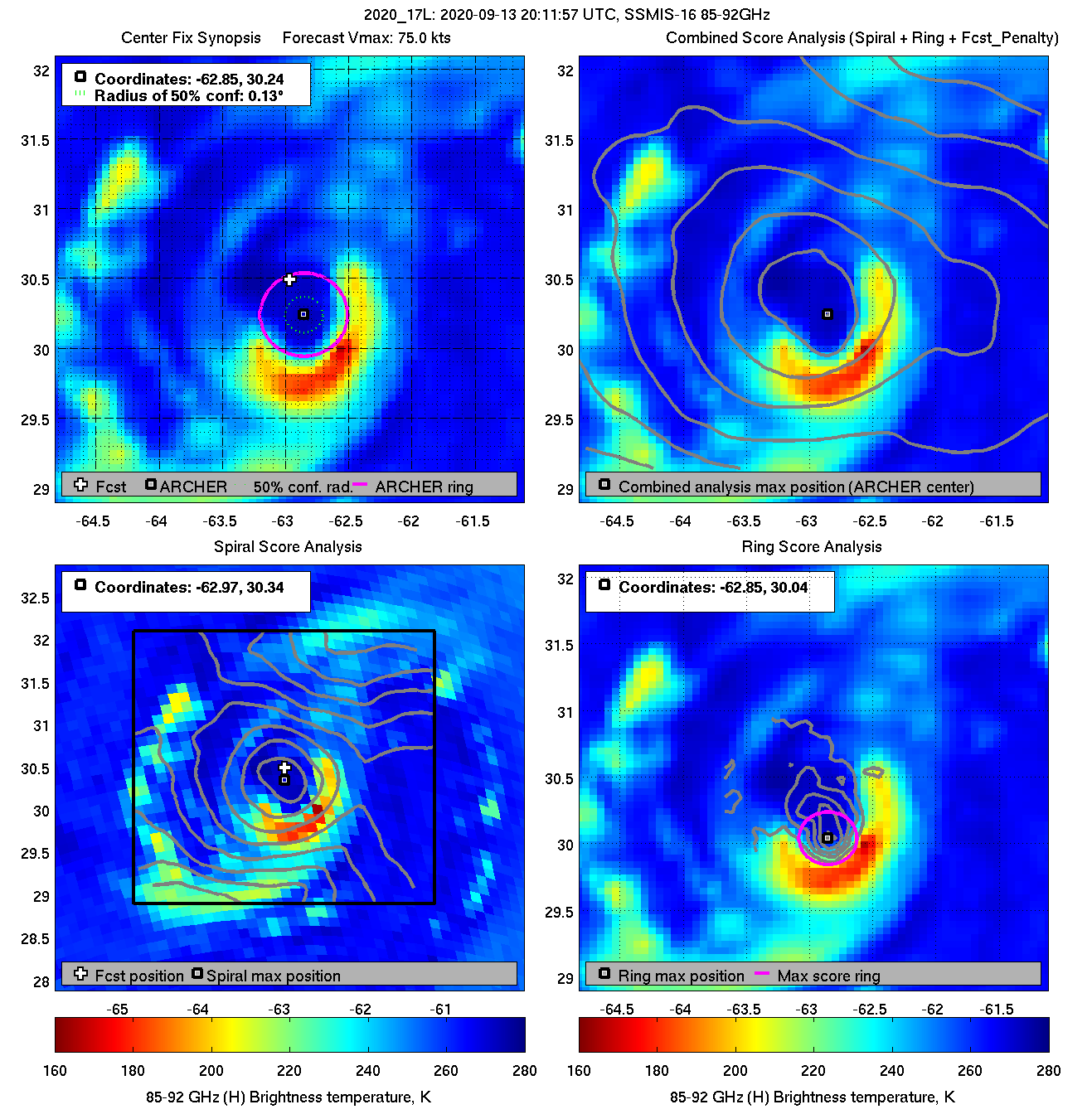
Latest microwave scan of Paulette this evening shows the deep convection continues only around the southern eyewall. Good for Bermuda.
 0
0 -
Bermuda airport is now reporting winds 050° 48 gust 77 knots, pressure 982 hPa.0
-
The NHC page for Teddy forecasts it will become a hurricane on Tuesday and a major hurricane by Friday, staying clear of population centres this week.
Death has this much to be said for it:
You don’t have to get out of bed for it.
Wherever you happen to be
They bring it to you—free.— Kingsley Amis
0 -
Teddy joins the crew
 0
0 -
Advertisement
-
Interesting METARs from Bermuda Airport this morning.METAR TXKF 140955Z 23011KT 3600 BR VCSH BKN007 OVC049 26/25 Q0972 RMK EYE OF HURCN PAULETTE=
METAR TXKF 1400855Z 14013KT 6000 VCSH BR FEW007 SCT025 BKN250 27/26 Q0973 RMK WSHFT 30=
METAR TXKF 1400755Z 08033G44KT 4000 -SHRA BLPY BKN005 BKN020 OVC250 27/25 Q0975=
METAR TXKF 140655Z 05048G77KT 1200 SHRA BLPY BKN006TCU OVC021 25/25 Q0982 RMK EMBDD TCU ALQDS=
METAR TXKF 140555Z 06043G61KT 2800 -SHRA BLPY BKN009 BKN019 BKN110 OVC300 25/25 Q0990 RMK PRESFR=
METAR TXKF 140455Z 06035G48KT 8000 -SHRA BKN014 BKN036 OVC047 27/24 Q0996 RMK TCU DSNT E-SE=
08033G44KT = Wind easterly (080 °C), 10-minute mean speed 33 knots, gust of 44 knots in the past 10 minutes.
Q972 = surface pressure 972 hPa
PRESFR = Pressure falling rapidly.
TCU DSNT NE = Distant Towering Cumulus clouds to the northeast.0 -
The eye is now moving off to the northwest of the island, with strong southwesterly winds from the southern eyewall getting in. Weather is Blowing Spray and a nearby shower.METAR TXKF 141055Z 24048G62KT 3200 BPLY VCSH OVC010TCU 26/25 Q0977 RMK TCU E=0
-
We now have Vicky
 0
0 -
Vicky has made a cameo appearance but will be short-lived, shear weakening it again over the next day or two.
 0
0 -
Sally is yet another Rapidly Intensifying Gulf storm. At the point it wouldn't surprise me in the least to see a Category 3 landfall, as has been the case so often in recent years she hit the warm Eddy in the GoM and has been bombing out ever since.
It's a very worrying trend to see these RI events occurring so close to landfall. It undermines the ability of weather forecasters and government officials alike to make predictions as to how large scale an evacuation may be needed, etc. The tightrope of "overstate it too often and people become immune to the threat and ignore future warnings, understate it and it's too late to evacuate" is become a lot more difficult in light of this.
Jeff Masters did a post on it a few weeks ago:
https://yaleclimateconnections.org/2020/08/climate-change-is-causing-more-rapid-intensification-of-atlantic-hurricanes/
2020 will surely be remembered as the year of last-minute monsters. I don't know enough about modelling science to say whether weather models could be theoretically designed to take this new era of rapid intensification into account when predicting landfall strength, but at the moment it seems that all of the models under-perform in this regard, with the exception of the ICON and HWRF models which, unfortunately, have the opposite issue in that they tend to falsely predict RI events too often such that when one is genuinely about to occur, too many people say "sure, but the HWRF / ICON models are always doing this, it's nothing to be concerned about really".0 -
hatrickpatrick wrote: »Sally is yet another Rapidly Intensifying Gulf storm. At the point it wouldn't surprise me in the least to see a Category 3 landfall, as has been the case so often in recent years she hit the warm Eddy in the GoM and has been bombing out ever since.
It's a very worrying trend to see these RI events occurring so close to landfall. It undermines the ability of weather forecasters and government officials alike to make predictions as to how large scale an evacuation may be needed, etc. The tightrope of "overstate it too often and people become immune to the threat and ignore future warnings, understate it and it's too late to evacuate" is become a lot more difficult in light of this.
Jeff Masters did a post on it a few weeks ago:
https://yaleclimateconnections.org/2020/08/climate-change-is-causing-more-rapid-intensification-of-atlantic-hurricanes/
2020 will surely be remembered as the year of last-minute monsters. I don't know enough about modelling science to say whether weather models could be theoretically designed to take this new era of rapid intensification into account when predicting landfall strength, but at the moment it seems that all of the models under-perform in this regard, with the exception of the ICON and HWRF models which, unfortunately, have the opposite issue in that they tend to falsely predict RI events too often such that when one is genuinely about to occur, too many people say "sure, but the HWRF / ICON models are always doing this, it's nothing to be concerned about really".
Sally has actually been over a cold eddy, not a warm one.
The increase in aircraft recon missions, sometimes with two or three aircraft in and around a storm at the same time, most definitely has something to do with the increase in detection of RI events. Several storms have been upped in intensity solely due to last-minute recon data. The record is not homogeneous and therefore the type of language of certainty by Masters in his blog is a bit unwarranted.0 -
Advertisement
-
Will we see any action from these yokes that are knocking about the mid Atlantic?0
-
smellyoldboot wrote: »Will we see any action from these yokes that are knocking about the mid Atlantic?
Very unlikely.0 -
smellyoldboot wrote: »Will we see any action from these yokes that are knocking about the mid Atlantic?
I asked that same question in the current weather - Autumn 2020 thread. I just checked the normally reliable ecmwf charts for the next seven days. Paulette is hovering around the North Atlantic but is expected to weaken and dissipate by the end of the week.
I also noticed of a very large and deepening area potentially horrendous low pressure system, that at the moment could impact Greenland and has a chance to impact ourselves early next week, but hopefully the high pressure over the British Isles will become some kind of blocking high for next weeks weather.
At this time I don't look no further than seven days ahead in the weather forecasts, due to this volatile hurricane situation in the North and mid Atlantic.0 -
Five named systems in the Atlantic: this has only happened once before since we developed the capability to monitor the whole ocean, and that was back in September 1971. There were six storms then: Edith, Fern, Ginger, Heidi and Irene, plus one officially named "Unnamed".
Death has this much to be said for it:
You don’t have to get out of bed for it.
Wherever you happen to be
They bring it to you—free.— Kingsley Amis
0 -
Teddy is set to develop into a major hurricane by Friday with Bermuda a possible landfall if it continues along its current vector. Really hope our high pressure hangs on, the jetstream looks to be keeping away from us for another 10 days at least.0
-
Advertisement
-
NOAA aircraft that measured SFMR winds up to 78 knots in the northwest eyewall of Sally earlier is about to come in around for another pass into that area now. Interesting to see what it measures. There were some suspect SFMR readings immediately after that 78 knots one, so we'll see if we get anything that high or higher now.

 0
0 -
That KVOA station is a Petronius oil platform and is the closest to the centre now. It's reporting northeast winds of 56 gust 69 knots at an anemometer height of 16 metres. The 56-knot 10-minute mean wind would equate to around 64 knots 1-minute in NHC speak. Pressure 966.4 hPa.
https://www.wrh.noaa.gov/map/?&zoom=7&scroll_zoom=true¢er=28.7000,-87.2000&basemap=OpenStreetMap&boundaries=true,false,false&hazard=true&hazard_type=hi-all&hazard_opacity=60&obs=true&obs_type=weather&elements=temp,dew,wind,rh,gust,slp&obs_popup=true&obs_density=10 -
Aircraft measured max SFMR wind of 78 knots in the NW eyewall now, but flight level wind of only 69 knots in the same area. Unusual to have a FL wind lower than the SFMR. Minimum pressure 988.6 hPa.
That oil platform is now up to 65 gusting 80 knots.0 -
Slow moving Sally is a serious threat between storm surge and rainfall totals as well as the wind speed.
About 300mm = 1 foot/12 inches NHCSTORM SURGE: The combination of a dangerous storm surge and the
tide will cause normally dry areas near the coast to be flooded by
rising waters moving inland from the shoreline. The water could
reach the following heights above ground somewhere in the indicated
areas if the peak surge occurs at the time of high tide...
Mouth of the Mississippi River to Ocean Springs, MS including Lake
Borgne...7-11 ft
Ocean Springs, MS to Dauphin Island, AL...6-9 ft
Mobile Bay...5-8 ft
Lake Pontchartrain and Lake Maurepas...3-5 ft
Dauphin Island, AL to AL/FL Border...4-6 ft
Port Fourchon, LA to Mouth of the Mississippi River...2-4 ft
AL/FL Border to Chassahowitzka, FL including Pensacola Bay,
Choctawhatchee Bay, and Saint Andrew Bay...1-3 ft
Burns Point, LA to Port Fourchon, LA...1-2 ft
Overtopping of local levees outside of the Hurricane and Storm
Damage Risk Reduction System is possible where local inundation
values may be higher than those shown above.
RAINFALL: Sally is expected to be a slow moving system as it
approaches land, producing 8 to 16 inches of rainfall with isolated
amounts of 24 inches over portions of the central Gulf Coast from
the western Florida Panhandle to far southeast Louisiana through the
middle of the week. Life-threatening flash flooding is likely. In
addition, this rainfall will likely lead to widespread minor to
isolated major flooding on area rivers.0 -
Sally now a Cat 20
-
That oil platform KVOA actually has an anemometer height of 160 metres above the sea surface, which is why reported a peak 8-minute wind of 87 knots (converting to a 1-minute mean of around 96 knots) and a gust of 102 knots as the northwestern eyewall passed through. At the standard 10 metres height the 96 knots would reduce to around 77 knots.
Buoy 42040, 30 miles to the west, has reported peak 8-minute of 39 knots (44 knots 1-minute). 0
0 -
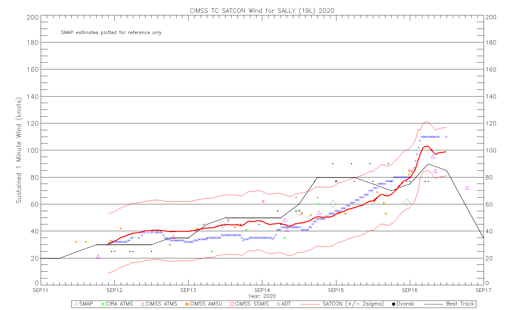
The latest satcon intensity estimate shows what I was saying earlier about the difference frequent aircraft recon data have on official intensity fixes. The classical satellite estimates are all shown in various colours while the official NHC best track estimate is in grey. The NHC have gone way above all of the satcon estimates today as recon data have come in. Without these the official intensity would have been more like somewhere around 60 knots. This has happened on several other occasions too, which calls into question the validity of comparing rapid intensity trends of recent years, when recon aircraft have become like bees around a hive. How many historical storms have had similar real intensities and not had them measured by aircraft?
 0
0 -
Sally has weakened overnight and aircraft data haven't found any surface winds above 58 knots, nor have there been surface buoy or platform winds that high, yet the NHC continue to give it an intensity of 75 knots. I sometimes struggle to understand their logic.Hurricane Sally Discussion Number 16...Corrected
NWS National Hurricane Center Miami FL AL192020
400 AM CDT Tue Sep 15 2020
Corrected Key Messages 2 and 3
There has been little change overall in Sally's convective
structure in both satellite and Doppler radar data. An eye has tried
to close off several times this morning, but after less than 30
minutes the southern eyewall has eroded. Until just recently, the
central pressure had been steady for the past several hours at 986
mb. However, the most recent Air Force Reserve reconnaissance pass
through Sally's center reported a dropsonde pressure of 984 mb and
13 kt winds, which equals a pressure of 983 mb. Maximum 700-mb
flight-level winds observed have only been 63 kt and peak SFMR
winds have been 58 kt. Also, reports from nearby oil rigs have
dropped off significantly since yesterday are are now in the 40-50
kt range. Based on these data, the initial intensity has been
lowered to 75 kt.
The initial motion estimate to 300/02 kt. After a brief jog due
west, it appears that Sally has resumed a slow drift toward the
west-northwest. Sally is embedded within weak steering flow based
on 0000Z upper-air data indicating 500-mb heights of 5900 meters
and slightly higher surrounding the cyclone from Florida northward
into the Tennessee Valley and then westward into the central and
southern Plains. This weak steering pattern is expected to persist
for the next few days, with a weak mid-level trough forecast to
move into the Missouri and Tennessee Valleys by Wednesday and
Thursday, which will gradually lift Sally northward and then
northeastward. Sally is forecast to merge with a frontal system by
day 4 or 5. The new NHC forecast track is similar to the previous
advisory and lies down the middle of the rather divergent model
guidance envelope.
Sally is now expected to remain in a moderate to high mid-to
upper-level wind shear environment. Ina addition, some modest
upwelling is likely occurring in the inner-core region based a SST
decrease of nearly 2 deg F during the past 24 hours based on data
from buoy 42012. After the Sally makes landfall, rapid weakening is
forecast and Sally should become post-tropical in 3 days or less.
Users are reminded to not focus on the exact forecast track or the
specific timing and location of landfall. Hurricane-force winds,
dangerous storm surge, and flooding rainfall will affect a large
portion of the north-central Gulf Coast during the next few days.
KEY MESSAGES:
1. It is still too early to determine where Sally's center will move
onshore given the uncertainty in the timing and location of Sally's
northward turn near the central Gulf Coast. Users should not focus
on the details of the official forecast track, since NHC's average
forecast error at 36 hours is around 60 miles, and dangerous storm
surge, rainfall, and wind hazards will extend well away from the
center.
2. An extremely dangerous and life-threatening storm surge is
expected for areas outside the southeastern Louisiana Hurricane and
Storm Damage Risk Reduction System from the Mouth of the Mississippi
River to the Okaloosa/Walton County Line in the Florida Panhandle,
where a Storm Surge Warning is in effect. Residents in these areas
should follow any advice given by local officials.
3. Hurricane conditions are expected today within the Hurricane
Warning area along the Mississippi and Alabama coastlines and the
western Florida Panhandle. Tropical storm conditions are already
occurring in some of these areas.
4. Historic flooding is possible with extreme life-threatening flash
flooding likely through Wednesday along and just inland of the
central Gulf Coast from the western Florida Panhandle to far
southeastern Mississippi. Widespread moderate to major flooding on
area rivers is forecast along and just inland of the central Gulf
Coast. Significant flash and urban flooding, as well as widespread
minor to moderate river flooding is likely across inland portions of
Mississippi, Alabama, northern Georgia, and the western Carolinas
through the week.
FORECAST POSITIONS AND MAX WINDS
INIT 15/0900Z 28.9N 88.1W 75 KT 85 MPH
12H 15/1800Z 29.2N 88.4W 75 KT 85 MPH
24H 16/0600Z 29.9N 88.5W 75 KT 85 MPH
36H 16/1800Z 30.6N 88.3W 60 KT 70 MPH...INLAND
48H 17/0600Z 31.4N 87.5W 35 KT 40 MPH...INLAND
60H 17/1800Z 32.2N 86.2W 25 KT 30 MPH...INLAND
72H 18/0600Z 32.8N 84.6W 20 KT 25 MPH...POST-TROP/REMNT LOW
96H 19/0600Z 33.2N 81.3W 20 KT 25 MPH...POST-TROP/EXTRATROP
120H 20/0600Z...DISSIPATED
I like the subtle pun in the discussion on TS Teddy, which is forecast to become a Cat 3 later on.....
Teddy bears watching in the long range for
category 4 strength, but regardless of the details, all of the
guidance show it becoming a classical large and powerful September
hurricane.
...0 -
Teddy bears down on Bermuda would make a good headline (earlier on it was supposed to miss by a small margin to the east, the 00z GFS takes it right over top of Bermuda).
Looked earlier like neither Paulette nor Sally would have any time as a major so the count remains 20/7/1 until Teddy boosts it to 20/8/1 or 20/8/2 perhaps tonight or tomorrow. (added later _ Sally moving at a snail's pace towards landfall has intensified more than predicted and is a borderline cat-3 storm now, advisory not out yet but 110 mph winds detected) ... Vicky does not seem to have much of a future either (although she stubbornly clings to 50 mph intensity).
So really if the season were to be at 13/8/1 or 2 it would seem rather anemic, and there have been at least seven weak tropical storms, so ... it continues to underwhelm somewhat.
Just as with 2005, it's female named storms that are the stronger of the two.0 -
Check out the Medicane off the coast of Greece.
https://earth.nullschool.net/#current/wind/surface/level/orthographic=-340.11,35.77,1002/loc=4.004,33.009
Going to strengthen as well into a powerful tropical like storm and hit Greece.0 -
Advertisement


Advertisement