Advertisement
If you have a new account but are having problems posting or verifying your account, please email us on hello@boards.ie for help. Thanks :)
Hello all! Please ensure that you are posting a new thread or question in the appropriate forum. The Feedback forum is overwhelmed with questions that are having to be moved elsewhere. If you need help to verify your account contact hello@boards.ie

Ireland's Most Interesting Bridges

Options
2456711

Comments

  • Closed Accounts Posts: 13,549 ✭✭✭✭Judgement Day


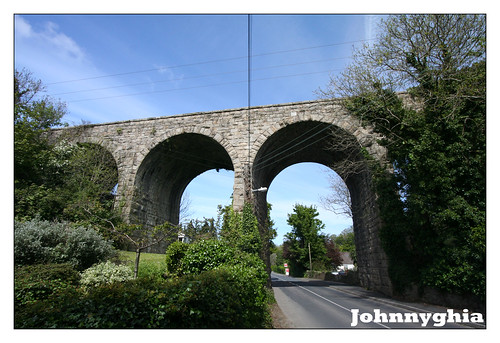
    Keeping up the matrimonial theme of the thread I include the former Harcourt Street line viaduct at the Brides Glen nr.Loughlinstown. When I was last on the viaduct in the 1970s it was in a quiet secluded spot but since the 'developments' at Cherrywood I suspect that this is no longer the case - I won't go back in case it spoils my memories of the place. I think that I'm correct in saying that the eventual extension of the Green Luas line (B2) to Bray will see track back on the viaduct? http://www.rpa.ie/en/projects/luas_bray_fassaroe/route_selection/Pages/default.aspx
    3550444079_55f2d30875.jpg
    The viaduct as seen from below.
    3551248780_d221db815e.jpg
    The view westwards from the top of the viaduct.

    Both views by kind permission of John Burke.
    More pics on his Flickr site here:http://www.flickr.com/photos/johnnyghia1302/3551248780/in/photostream/


  • Closed Accounts Posts: 13,549 ✭✭✭✭Judgement Day


    When I was a child growing up in Bray we regularly used to make the short trip to Enniskerry for picnics, and the twisty little road to the village that follows the course of the River Dargle from the N11 passed this picturesque footbridge - reminiscent of the earlier one at the Vartry Reservoir.
    glassplates&CISOPTR=10883
    This is Lawrence photograph from the National Library of Ireland and the collection can be viewed online at: http://www.nli.ie/en/udlist/photographs-collections.aspx


  • Registered Users Posts: 24,479 ✭✭✭✭Cookie_Monster


    Keeping up the matrimonial theme of the thread I include the former Harcourt Street line viaduct at the Brides Glen nr.Loughlinstown. When I was last on the viaduct in the 1970s it was in a quiet secluded spot but since the 'developments' at Cherrywood I suspect that this is no longer the case - I won't go back in case it spoils my memories of the place. I think that I'm correct in saying that the eventual extension of the Green Luas line (B2) to Bray will see track back on the viaduct?

    this is pretty easily accessible now due to the estate backing right onto it. I can see it from the canteen in work

    Some very tight turns required for the Luas if it is to get there, I think they will build a new bridge rather than use this one, mad as that sounds


  • Registered Users Posts: 1,132 ✭✭✭Stonewolf


    trellheim wrote: »
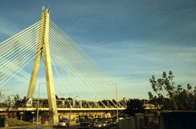
    I think the LUAS bridge at Dundrum sweeps over the junction nicely

    125237_f8bd7426.jpg

    I do quite like that bridge. Firstly it's cable stayed which is far more aesthetically pleasing and more interesting engineering than the usual "ah sure we'll put up some concrete peirs and stick some concrete decking on top, it'll do like". Secondly, it's down low and the area around it is very accessible to the public so you can actually walk around it, see it from some great angles and of course, the engineering of the bridge is all on show which is fantastic.

    The bridges in #13 #27 and #33 are really nice, I like how they've taken what would be a fairly regular bridge and really made it into something interesting and different. The chetwynd viaduct in #14 is also rather handsome, it's a shame it doesn't have its deck on.


  • Registered Users Posts: 5,543 ✭✭✭veryangryman


    KC61 wrote: »
    Fascinating stuff JD - an excellent thread!!! You deserve a kudo for this one!

    Make that 2 :)


  • Advertisement
  • Registered Users Posts: 5,879 ✭✭✭trellheim


    There are two more of the Vartry style bridges at Bohernabreena

    761529-Bohernabreena_Waterworks-Dublin.jpg

    they are actually links to the valve houses to allow the reservoirs be drained, normally locked off

    Although you do see kids in the summer jumping off. hideously dangerous as there is up to 48-inch pipe entrys directly below.


  • Moderators, Business & Finance Moderators, Motoring & Transport Moderators, Society & Culture Moderators Posts: 67,948 Mod ✭✭✭✭L1011


    e474e4fce9.jpg

    Cathleens' Falls bridge, 3 lane road with pedestrian bridge suspended beneath it.


  • Registered Users Posts: 1,132 ✭✭✭Stonewolf


    MYOB wrote: »
    e474e4fce9.jpg

    Cathleens' Falls bridge, 3 lane road with pedestrian bridge suspended beneath it.

    That's a nice bridge alright, I've only ever seen it during the day though, lit up like that it looks fantastic.


  • Closed Accounts Posts: 13,549 ✭✭✭✭Judgement Day


    MYOB wrote: »

    Cathleens' Falls bridge, 3 lane road with pedestrian bridge suspended beneath it.

    Wow! Like something from a Sci-Fi movie. How old is it?

    On a different tack - I have searched the internet for a photo of one of the border crossing bridges as altered by British security services - I don't mean a blown up bridge! Something with corrugated sheeting and a watchtower. Anybody?


  • Moderators, Business & Finance Moderators, Motoring & Transport Moderators, Society & Culture Moderators Posts: 67,948 Mod ✭✭✭✭L1011


    5 years or less, its part of the N15 Bundoran/Ballyshannon bypass.


  • Advertisement
  • Closed Accounts Posts: 9,700 ✭✭✭tricky D


    Broom Bridge on the Royal Canal near Cabra has a bit of interest if you're up on your complex maths.


    Also the original keystones (head sculptures) from O'Connell Bridge made their way to a building on Sir John Rogerson's Quay when they widened it in the 19th C. (Will dig up a photo sometime)


  • Registered Users Posts: 4,282 ✭✭✭westtip


    MYOB wrote: »
    5 years or less, its part of the N15 Bundoran/Ballyshannon bypass.

    My god I have driven over it dozens of times and never seen it at this angle (just as well as I am in a car) Nice bit of lighting on modern architecture does wonders!


  • Closed Accounts Posts: 3,032 ✭✭✭DWCommuter


    Keeping up the matrimonial theme of the thread I include the former Harcourt Street line viaduct at the Brides Glen nr.Loughlinstown. When I was last on the viaduct in the 1970s it was in a quiet secluded spot but since the 'developments' at Cherrywood I suspect that this is no longer the case - I won't go back in case it spoils my memories of the place. I think that I'm correct in saying that the eventual extension of the Green Luas line (B2) to Bray will see track back on the viaduct? http://www.rpa.ie/en/projects/luas_bray_fassaroe/route_selection/Pages/default.aspx
    3550444079_55f2d30875.jpg
    The viaduct as seen from below.
    3551248780_d221db815e.jpg
    The view westwards from the top of the viaduct.

    Both views by kind permission of John Burke.
    More pics on his Flickr site here:http://www.flickr.com/photos/johnnyghia1302/3551248780/in/photostream/


    Nice viaduct and very well hidden. Not as well known as the "arches". But I'm trying to find a snap I have of the alignment across it, littered with beer cans, condoms and camp fire remains.:D Seriously.

    My personal faves are Gleensk viaduct and Chetwynd for sheer scale and beauty.


  • Closed Accounts Posts: 13,549 ✭✭✭✭Judgement Day


    pict3743.jpg
    Another one from the Tralee & Dingle Light Railway to finish me for today. Hard to believe that this peaceful spot on a bend on the N86 Tralee/Dingle road was the scene of carnage on May 22nd, 1893. A fair special from Dingle containing passengers and a consignment of pigs ran away down the notorious Glen-na-galt bank (3 miles of falling gradient at 1:30) and crashed off the western side of the viaduct. The train was estimated to be travelling at 40 mph when it derailed instead of the regulation 6 mph! The three railway men on the footplate were killed in the crash and 13 passengers were injured some seriously. The full Board of Trade report into the accident is available as a pdf file and makes fascinating reading: http://www.tdlr.org.uk

    Some of the points undercovered during the enquiry found that the train was being driven by a locomotive inspector not familiar with the line, that the railway equipment itself was defective and that that the railway had been built on the cheap thereby leading to overly steep inclines and sharp curves - literally cutting corners to save money. Although some slight easing of the curves was carried out in the years following the accident it was not until 1907 that a new bridge and associated deviation was completed. See photo and map below - by kind permission of Ted Polet. His website: http://www.narrowgauge.nl/site/english/tdsurvey.htm contains other drawings and photographs of the Tralee & Dingle today.

    curraduff.jpg

    And below the 'new' 1907 deviation bridge which is still in situ today.
    pict3746.jpg

    Interestingly the insignificant Finglas River was crossed by no less than four bridges in close proximity -the two pictured here, the Tralee/Dingle road bridge and a short distance north of the accident scene the Castlegregory branch of the T&D also crossed the river but sadly only the abutments survive today hidden in the trees.

    Further fascinating information about the T&D is available at: http://www.tdlr.org.uk/


  • Banned (with Prison Access) Posts: 616 ✭✭✭pearljamfan


    Dainty and obscure this fairytale structure is at the Vartry Reservoir nr.Roundwood in Co.Wicklow.

    VartryReservoirRoundwoodCoWicklow.jpg


    can u walk on it or is it closed off???


  • Closed Accounts Posts: 3,032 ✭✭✭DWCommuter


    From my locality;


    monasterevin_600.jpg


  • Closed Accounts Posts: 3,032 ✭✭✭DWCommuter


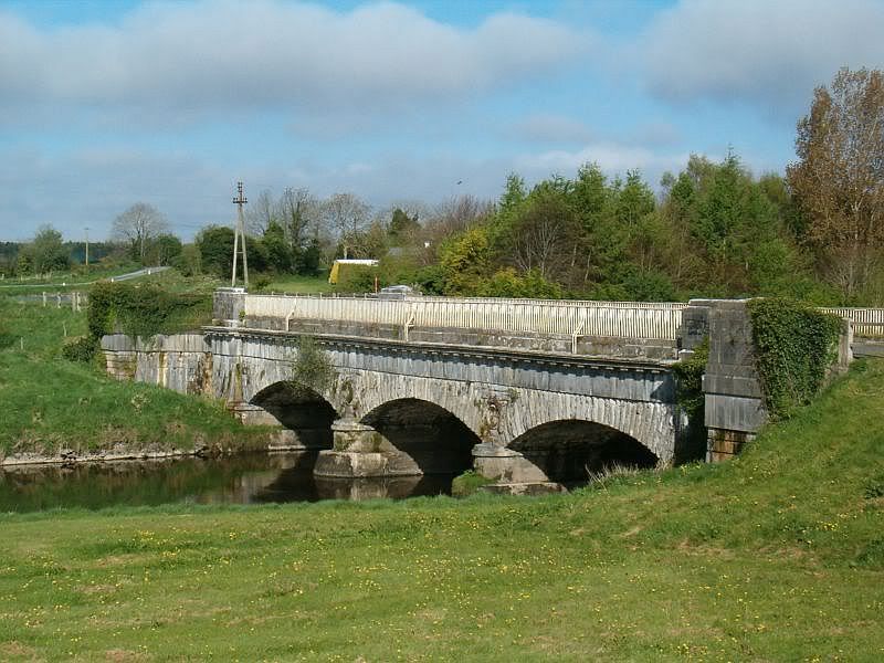
    I think this bridge near Ardnacrusha dam is interesting, because its representative of a more modern Ireland in its infancy. A very distinctive structure that still stands out in the locality. Similar structures are present along this particular man made water channel to divert the shannon to the power station. A stunning piece of infrastructure for those who can appreciate the enormity of it in the late 1920s.

    ardnacrusha2_resize.jpg


  • Closed Accounts Posts: 3,032 ✭✭✭DWCommuter


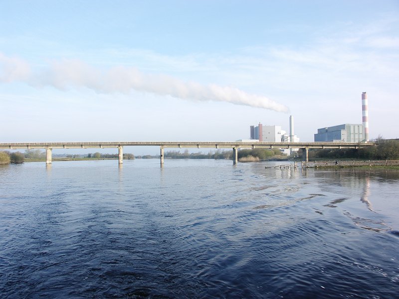
    One final contribution from me tonight. The Bord na Mona Shannon rail bridge, that runs into the Former Ballinasloe Grand Canal branch (converted to rail use). A modern structure by all accounts and built at considerable cost to link the oul turf with a power station. Little known railway crossing of the shannon, but beautiful all the same.

    Pict7942.jpg


  • Closed Accounts Posts: 5,731 ✭✭✭Bullseye1


    The pedestrian bridge at the Enniskerry juntion N11. What a waste of money.


  • Moderators, Business & Finance Moderators, Motoring & Transport Moderators, Society & Culture Moderators Posts: 67,948 Mod ✭✭✭✭L1011


    DWCommuter wrote: »
    I think this bridge near Ardnacrusha dam is interesting, because its representative of a more modern Ireland in its infancy. A very distinctive structure that still stands out in the locality. Similar structures are present along this particular man made water channel to divert the shannon to the power station. A stunning piece of infrastructure for those who can appreciate the enormity of it in the late 1920s.

    From the top, most of the ESB-built bridges over both the 'proper' channel and the headrace seem very similar - I'd presume they all resemble this one from water level? They're far more elegant below than above in this case. They're without exception realistically too narrow for two lanes of modern traffic now, unfortunately.


  • Advertisement
  • Closed Accounts Posts: 13,549 ✭✭✭✭Judgement Day


    can u walk on it or is it closed off???

    Locked off and only a thrill seeker will try and climb out on to it. :D


  • Registered Users Posts: 742 ✭✭✭Jayuu


    MYOB wrote: »
    e474e4fce9.jpg

    Cathleens' Falls bridge, 3 lane road with pedestrian bridge suspended beneath it.

    Beautiful bridge. I wonder its like to walk with the traffic directly above you.

    There's another spectacular picture of this on Flickr if you do a Google image search on "Cathleens' Falls bridge". Its taken from a distance and you can see how the lighting affects the local landscape. Quite amazing actually.

    Because I don't know the owner of the image I don't want to directly link to it.


  • Registered Users Posts: 4,282 ✭✭✭westtip


    pict3743.jpg
    Another one from the Tralee & Dingle Light Railway to finish me for today. Hard to believe that this peaceful spot on a bend on the N86 Tralee/Dingle road was the scene of carnage on May 22nd, 1893. A fair special from Dingle containing passengers and a consignment of pigs ran away down the notorious Glen-na-galt bank (3 miles of falling gradient at 1:30) and crashed off the western side of the viaduct. The train was estimated to be travelling at 40 mph when it derailed instead of the regulation 6 mph! The three railway men on the footplate were killed in the crash and 13 passengers were injured some seriously. The full Board of Trade report into the accident is available as a pdf file and makes fascinating reading: http://www.tdlr.org.uk

    Some of the points undercovered during the enquiry found that the train was being driven by a locomotive inspector not familiar with the line, that the railway equipment itself was defective and that that the railway had been built on the cheap thereby leading to overly steep inclines and sharp curves - literally cutting corners to save money. Although some slight easing of the curves was carried out in the years following the accident it was not until 1907 that a new bridge and associated deviation was completed. See photo and map below - by kind permission of Ted Polet. His website: http://www.narrowgauge.nl/site/english/tdsurvey.htm contains other drawings and photographs of the Tralee & Dingle today.

    curraduff.jpg

    And below the 'new' 1907 deviation bridge which is still in situ today.
    pict3746.jpg

    Interestingly the insignificant Finglas River was crossed by no less than four bridges in close proximity -the two pictured here, the Tralee/Dingle road bridge and a short distance north of the accident scene the Castlegregory branch of the T&D also crossed the river but sadly only the abutments survive today hidden in the trees.

    Further fascinating information about the T&D is available at: http://www.tdlr.org.uk/

    JD I am getting all excited about cycling across these greenway bridges.


  • Registered Users Posts: 7,476 ✭✭✭ardmacha


    This one is somewhat unusual

    Co%20Clare,%20Lisdoonvarna,%20Spectacle%20Bridge%201900%27s.jpg


  • Registered Users Posts: 5,879 ✭✭✭trellheim


    is that one still there ?


  • Closed Accounts Posts: 3,032 ✭✭✭DWCommuter


    trellheim wrote: »
    is that one still there ?

    It is indeed.


  • Registered Users Posts: 7,476 ✭✭✭ardmacha


    The GNR main line has two fine bridges near Newry.

    The Bessbrook Viaduct, now more visible from the Newry bypass, which is less beautiful.
    image.aspx?ImageID=75489&Width=300&Height=200&Bg=-1185311


    and the neighbouring "Egyptian" arch.
    egyptian-arch.jpg


    and all manner of bridges here
    http://www.ihpc.ie/ihpc/main/IrishLifeCategory.asp?iCategoryID=82&iCategoryTypeID=9


  • Moderators, Education Moderators Posts: 5,026 Mod ✭✭✭✭G_R


    DWCommuter wrote: »
    From my locality;


    monasterevin_600.jpg

    You must live near to me so. I was just gonna post a few of the aqueduct.

    HPIM3363.jpg
    monasterevin04.JPG

    Just in case anyone doesn't know the story, its where the Royal Canal passes over the River Barrow. Open to correction, but as far as I know, its the only water over water crossing in Ireland.

    Monasterevin is actually full of bridges, within 100m of each other there is 3 road bridges, the canal bridge and a bridge for the the train. Off the top of my head I can think of another 5 or 6, that has to be a record for a town this size.


  • Closed Accounts Posts: 13,549 ✭✭✭✭Judgement Day


    Monasterevan is certainly an interesting place for bridges and waterways. I think the bridge in question is technically called an aqueduct.
    Monasterevan's other two claims to fame are also visible from the railway - the grotto with the moving statue, and the site of the 1975 siege which resulted in the successful freeing of the Dutch industrialist Dr Tiede Herrema from his kidnappers at a house in St.Evins Park. Sorry for wandering off topic. :D

    PS And while I think of it, it is the Grand Canal rather than the Royal which crosses the River Barrow.


  • Advertisement
  • Moderators, Education Moderators Posts: 5,026 Mod ✭✭✭✭G_R


    Monasterevan is certainly an interesting place for bridges and waterways. I think the bridge in question is technically called an aqueduct.
    Monasterevan's other two claims to fame are also visible from the railway - the grotto with the moving statue, and the site of the 1975 siege which resulted in the successful freeing of the Dutch industrialist Dr Tiede Herrema from his kidnappers at a house in St.Evins Park. Sorry for wandering off topic. :D

    Thats the word!!!

    i was sitting here for 5 mins and it just wouldn't come to me.

    Thank you haha


Advertisement