Advertisement
If you have a new account but are having problems posting or verifying your account, please email us on hello@boards.ie for help. Thanks :)
Hello all! Please ensure that you are posting a new thread or question in the appropriate forum. The Feedback forum is overwhelmed with questions that are having to be moved elsewhere. If you need help to verify your account contact hello@boards.ie

Interesting Maps

1331332334336337341

Comments

  • Moderators, Category Moderators, Arts Moderators, Sports Moderators Posts: 52,763 magicbastarder
    CMod ✭✭✭✭


    Or to claim that we don't live in a democracy because the electorate have picked one of two parties consistently for that length of time, in free and fair elections.


  • Registered Users, Registered Users 2 Posts: 16,911 cj maxx
    ✭✭✭✭


    That’s a Kakistocracy ,


  • Registered Users, Registered Users 2 Posts: 30,606 zell12
    ✭✭✭✭


  • Registered Users, Registered Users 2 Posts: 661 minggatu
    ✭✭✭


    English proficiency

    surprised-about-germany-argentina-and-mexico-v0-0ydqlhsq2rxe1.jpg


  • Registered Users, Registered Users 2 Posts: 40,942 ohnonotgmail
    ✭✭✭✭


  • Advertisement
  • Registered Users, Registered Users 2 Posts: 16,911 cj maxx
    ✭✭✭✭


    yeah , but a choice between Charlie and Garret wasn’t much of a choice


  • Registered Users, Registered Users 2 Posts: 30,606 zell12
    ✭✭✭✭


    this group, called the “technocracy movement”, was a group of 1930s nonconformists with big ideas about how to rearrange US society.

    They proposed a vision that would get rid of waste and make North America highly productive by using technology and science. Advocates argued that traditional economic systems such as capitalism and socialism were inefficient and prone to corruption, but that a scientifically planned economy could ensure abundance, stability and fairness.

    The Technocrats proposed merging Canada, Greenland, Mexico, the US and parts of central America into a “Technate”. It was to be governed by technocratic principles, rather than by national borders and traditional political divisions.

    image.png


  • Registered Users, Registered Users 2 Posts: 16,911 cj maxx
    ✭✭✭✭


    Trump has much the same idea


  • Registered Users, Registered Users 2 Posts: 6,505 Charles Babbage
    ✭✭✭


    Not really, Trump has no knowledge of or interest in science, and fairness and stability do not seem to be his objectives.


  • Registered Users, Registered Users 2 Posts: 16,911 cj maxx
    ✭✭✭✭


    It was in jest


  • Advertisement
  • Moderators, Social & Fun Moderators Posts: 13,615 JupiterKid
    Mod ✭✭✭✭


    Forest type in Sweden

    Screenshot_20250429_185736_Chrome.jpg

    Sweden is 70% covered in forest compared to a paltry 12% in Ireland.

    Boreal is coniferous forest in the centre and north, mixed boreal and deciduous in the south of the country roughly below 61 N (olive colour) and deciduous forest in the very south denoted by a pale olive colour.


  • Registered Users, Registered Users 2 Posts: 30,606 zell12
    ✭✭✭✭


  • Moderators, Social & Fun Moderators Posts: 13,615 JupiterKid
    Mod ✭✭✭✭


    Liklihood of a white Christmas in Europe, 2022

    FB_IMG_1745868255582.jpg


  • Moderators, Social & Fun Moderators Posts: 13,615 JupiterKid
    Mod ✭✭✭✭


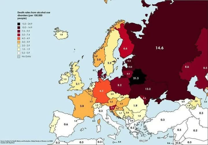
    Death rates from alcohol use disorders in Europe

    FB_IMG_1745868172415.jpg


  • Moderators, Social & Fun Moderators Posts: 13,615 JupiterKid
    Mod ✭✭✭✭


    The LEGO House in the centre of the town of Billund, Denmark as seen on Google maps - birthplace of the plastic brick. 🧱

    Screenshot_20250429_183430_Maps.jpg


  • Moderators, Category Moderators, Arts Moderators, Sports Moderators Posts: 52,763 magicbastarder
    CMod ✭✭✭✭


    Sweden is 70% covered in forest compared to a paltry 12% in Ireland.

    Always worth mentioning that native broadleaf woodland is a small fraction of that. Less than 2% the land area of the country. And native conifer woodland is much rarer still.


  • Moderators, Recreation & Hobbies Moderators, Science, Health & Environment Moderators, Technology & Internet Moderators Posts: 95,246 Capt'n Midnight
    Mod ✭✭✭✭


    From https://www.science.org/doi/10.1126/sciadv.adr6921distribution of fishmeal and fish oil factories around the globe

    image.png image.png

    image.png

    vs

    image.png


  • Registered Users, Registered Users 2 Posts: 30,606 zell12
    ✭✭✭✭


    Per capita egg consumption, 1961

    average per capita egg consumption, measured in kg/year (in shell weight).

    image.png

    Per capita egg consumption, 2022

    image.png


  • Registered Users, Registered Users 2 Posts: 661 minggatu
    ✭✭✭


  • Registered Users, Registered Users 2 Posts: 16,911 cj maxx
    ✭✭✭✭


    17460629675492011291507403820660.jpg

    Hopefully a map of every US military base in the world


  • Advertisement
  • Registered Users, Registered Users 2 Posts: 30,606 zell12
    ✭✭✭✭


    Ever looked at the map on the notes and..?

    image.png

    Europa series banknotes show architectural styles from various periods in Europe's history, but do not show any actual existing monuments or bridges.  Many other places have € as legal tender

    image.png


  • Moderators, Social & Fun Moderators, Regional East Moderators, Regional North West Moderators Posts: 12,846 miamee
    Mod ✭✭✭✭


    Apologies if shared before...percentage of population living within 15 minutes of a hospital

    Screenshot_20250425_141101_WhatsApp.jpg


  • Moderators, Category Moderators, Arts Moderators, Sports Moderators Posts: 52,763 magicbastarder
    CMod ✭✭✭✭


    would be interesting to compare that to population patterns - that map is down to a combination of (at least) two factors; how dispersed the population is, and how many hospitals there are.


  • Registered Users, Registered Users 2 Posts: 661 minggatu
    ✭✭✭


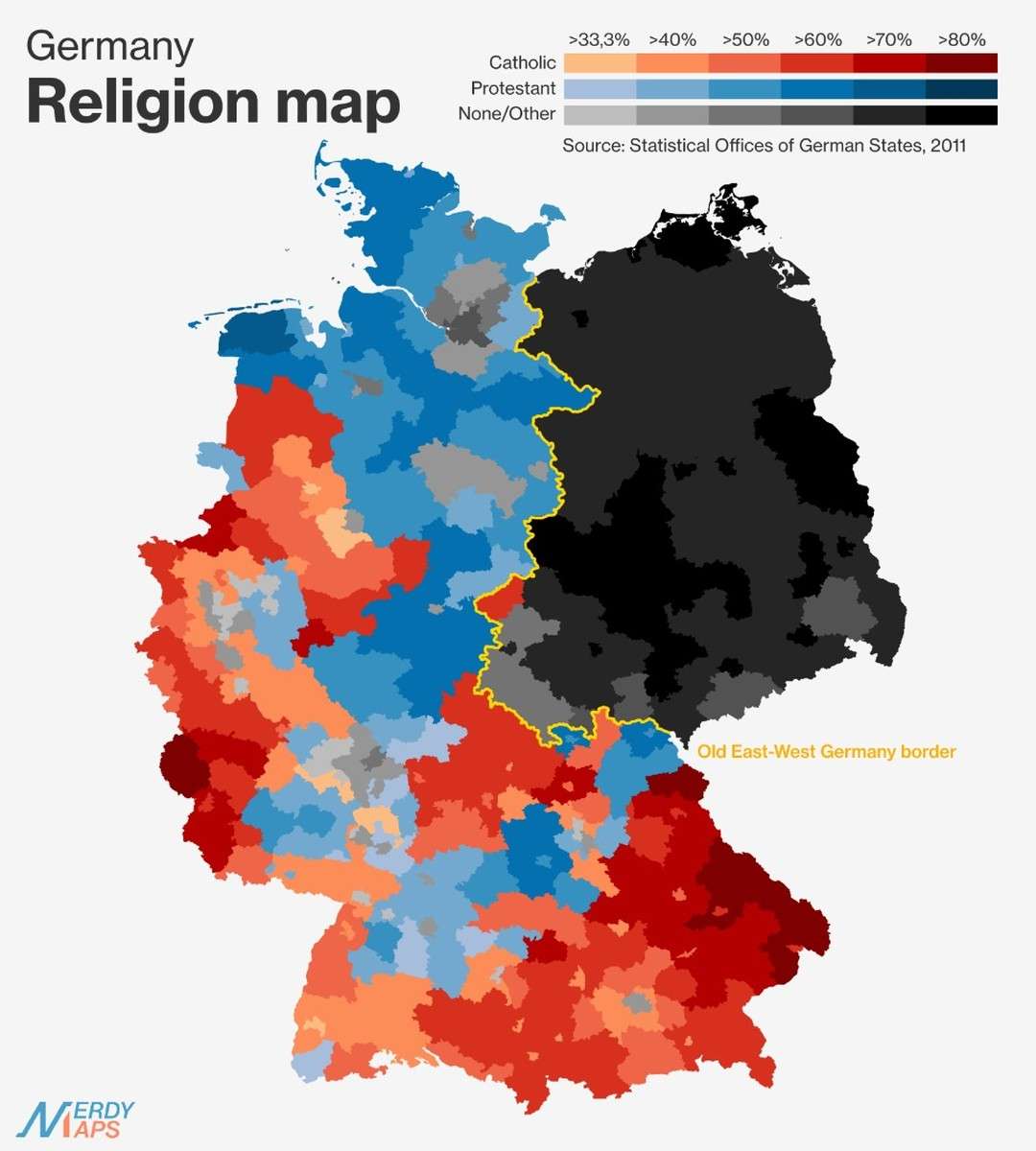
    Germany: Religious Divide

    author: nerdy.maps/instagram, added on: 2025-03-30

    Germany: Religious Divide


  • Registered Users, Registered Users 2 Posts: 14,816 josip
    ✭✭✭✭


    Duh


  • Registered Users, Registered Users 2 Posts: 16,911 cj maxx
    ✭✭✭✭


    Within 15 minutes . Monaghan it’s at least an hour on twisty roads to get to Cavan or Drogheda ? . Fcuk health minister from Cavan in the 80’s / 90’s


  • Registered Users, Registered Users 2 Posts: 72,970 L1011
    ✭✭✭✭


    Hospital map info is clearly bollox, there should be a hot spot around every hospital, or Dublin should be a solid colour if using NUTS regions

    Also - using TomTom data for what? Trusting a satnav to know what grade of hospital one is isn't useful, and you wouldn't want to think that Dungloe Hospital even has a doctor on site (it's effectively a nursing home now, even if it once had maternity and other services).

    Let alone the various protestant schools with Hospital in the name, or the village in Limerick!


  • Registered Users, Registered Users 2 Posts: 3,518 davetherave
    ✭✭✭


    NUTS

    Region name

    Value

    IE041

    Border

    31.4

    IE042

    West

    36.1

    IE051

    Mid-West

    46.3

    IE052

    South-East

    36.1

    IE053

    South-West

    47.0

    IE061

    Dublin

    92.2

    IE062

    Mid-East

    54.1

    IE063

    Midland

    42.4

    Data table of the hospitals

    The various sources -

    Map of Hospitals https://ec.europa.eu/assets/estat/E/E4/gisco/website/basic-services/healthcare-services/map/

    Population census https://ec.europa.eu/eurostat/web/gisco/geodata/population-distribution/geostat

    There is also a https://ec.europa.eu/eurostat/web/gisco/geodata/geographic-accessibility#Accessibility%20to%20healthcare%20services

    image.png


  • Moderators, Social & Fun Moderators, Regional East Moderators, Regional North West Moderators Posts: 12,846 miamee
    Mod ✭✭✭✭


    That's more like what I would have expected @davetherave

    For reference, the map I posted was shared by the European Commission on their Whatsapp channel (and presumably other social media).


  • Advertisement
  • Registered Users, Registered Users 2 Posts: 7,233 Damien360
    ✭✭✭


    A rant if you will.

    The issue I have with that Ireland map is a lot of our hospitals specialise so it's not true to say everyone is close to a hospital that is of any use. Naas is closest to me but I would keep going to Tallaght because so many services taken for granted are not in Naas.

    My wife had radiotherapy in St James in Dublin, but she was meeting women who had travelled from Donegal for the same treatment and had to stay over nearby due to travel distance. It is very specialised but even look at children's care. It's very much Dublin centric. There is a satellite service but it always bows to Dublin and having witnessed it in Blanchardstown (still in Dublin), no decision was made unless temple St was making the decision which is always delayed.

    So technically you may be close to a hospital but is it of any use ?


Welcome!

It looks like you're new here. Sign in or register to get started.
Advertisement