Advertisement
If you have a new account but are having problems posting or verifying your account, please email us on hello@boards.ie for help. Thanks :)
Hello all! Please ensure that you are posting a new thread or question in the appropriate forum. The Feedback forum is overwhelmed with questions that are having to be moved elsewhere. If you need help to verify your account contact hello@boards.ie
Help Keep Boards Alive. Support us by going ad free today. See here: https://subscriptions.boards.ie/.
If we do not hit our goal we will be forced to close the site.

Current status: https://keepboardsalive.com/

Annual subs are best for most impact. If you are still undecided on going Ad Free - you can also donate using the Paypal Donate option. All contribution helps. Thank you.
https://www.boards.ie/group/1878-subscribers-forum

Private Group for paid up members of Boards.ie. Join the club.

Interesting Maps

1312313315317318363

Comments

  • Moderators, Sports Moderators Posts: 7,505 Mod ✭✭✭✭cdeb


  • Registered Users, Registered Users 2 Posts: 781 ✭✭✭minggatu


    English words originating from languages around the world

    english-words-originating-from-languages-around-the-world.jpg

    https://mapsontheweb.zoom-maps.com/assets/maps/english-language/english-words-originating-from-languages-around-the-world.jpg


  • Registered Users, Registered Users 2 Posts: 4,214 ✭✭✭Brief_Lives


  • Registered Users, Registered Users 2 Posts: 31,771 ✭✭✭✭zell12


    'this is not a conclusive list'. Thousands of words missing

    The term “map” derives from Latin “mappa,” a word meaning in antiquity a napkin, or a cloth or flag used to signal the start of games.


  • Registered Users, Registered Users 2 Posts: 31,771 ✭✭✭✭zell12


    Donald Trump has pledged to abolish DST, labeling it as "inconvenient and costly". Two states already don't follow DST, 20 states are considering scrapping DST.

    No DST in American Samoa, Guam, Northern Mariana Islands, Puerto Rico, US Virgin Islands

    image.png


  • Advertisement
  • Registered Users, Registered Users 2 Posts: 31,771 ✭✭✭✭zell12


    Not a high speed rail! another missed opportunity

    Amtrak plans to double the number of passengers the NE corridor carries in the next three decades. If the works go to plan, the route could transport 66m people a year by 2040

    image.png


  • Registered Users, Registered Users 2 Posts: 31,771 ✭✭✭✭zell12


    Will high-speed rail ever happen in the USA? Potential

    image.png


  • Registered Users, Registered Users 2 Posts: 781 ✭✭✭minggatu


    Napoleon Bonaparte's First French Empire in 1812 napoleon-bonapartes-first-french-empire-in-1812.jpg

    more in the link

    https://mapsontheweb.zoom-maps.com/posts/european-history/napoleon-bonapartes-first-french-empire-in-1812


  • Moderators, Category Moderators, Education Moderators, Paid Member Posts: 27,418 CMod ✭✭✭✭spurious


    When I was at school in the 70s, they would have fitted on the Isle of Wight.


  • Moderators, Recreation & Hobbies Moderators Posts: 23,016 Mod ✭✭✭✭Brian?


    they/them/theirs


    The more you can increase fear of drugs and crime, welfare mothers, immigrants and aliens, the more you control all of the people.

    Noam Chomsky


  • Advertisement
  • Registered Users, Registered Users 2 Posts: 781 ✭✭✭minggatu


    Etymology map for the word "summer"

    etymology-map-for-the-word-summer.jpg

    Source:

    reddit.com


  • Moderators, Social & Fun Moderators, Paid Member Posts: 13,874 Mod ✭✭✭✭JupiterKid


    Human Development (HDI) Index of North America by US state and Canadian province, 2022

    FB_IMG_1741113949694.jpg


  • Registered Users, Registered Users 2, Paid Member Posts: 23,408 ✭✭✭✭dxhound2005


    Newfoundland (island section): 111,390 sq. km. Labrador (mainland section): 294,330 sq. km. It was a close run thing in 1948 when 52.3% voted to join Canada, 47.7% for independence. It was a British Dominion before that. In December 2001, the province of Newfoundland became officially the province of Newfoundland and Labrador following the adoption of an amendment to the Constitution of Canada.

    image.png


  • Registered Users, Registered Users 2, Paid Member Posts: 23,408 ✭✭✭✭dxhound2005


    St Pierre and Miquelon, French Overseas Territory, close by Newfoundland.

    image.png


  • Registered Users, Registered Users 2 Posts: 41,042 ✭✭✭✭ohnonotgmail


    The map only accounts for Irish primary schools. Secondary schools have 4 weeks more.


  • Registered Users, Registered Users 2 Posts: 6,715 ✭✭✭Charles Babbage


    UStrade.png

    Hopefully, Trump voters feel some discomfort in ND and Texas.


  • Registered Users, Registered Users 2 Posts: 31,771 ✭✭✭✭zell12


    Older than Canada, and invaded by Free French in 1941.

    Canada, concerned with mounting ship sinkings in the western Atlantic, believed that the powerful St. Pierre radio transmitter may have been sending coded messages to the Germans about British-bound convoys. Churchill commented that the station was spewing out “Vichy lies and poison throughout the world“. Despite opposition from Canada, Britain, and US, Charles de Gaulle's forces seized the archipelago from Vichy France, to which the local administrator had pledged its allegiance, in December 1941.


  • Registered Users, Registered Users 2, Paid Member Posts: 27,954 ✭✭✭✭Peregrinus


    He did. But the map shows the state of affairs in 1812, and I think he was run out of Egypt about 10 years before that.


  • Registered Users, Registered Users 2 Posts: 31,771 ✭✭✭✭zell12


    I'd be interested in any maps that show the effects of the 1920 Jones Act - very relevant today!

    Requires all goods transported by water between US ports be carried on ships that have been constructed in the US, fly the US flag, owned by US citizens, crewed by US citizens and permanent residents. It prevents foreign-flagged ships from carrying cargo between the contiguous US and certain non-contiguous parts of the US, such as Puerto Rico, Hawaii, Alaska, and Guam.


  • Registered Users, Registered Users 2 Posts: 31,771 ✭✭✭✭zell12


    stolen from here

    image.png

    Missed out on a few including Dyke Road, Galway.


  • Advertisement
  • Registered Users, Registered Users 2 Posts: 31,771 ✭✭✭✭zell12


    Your great-grandfather's school map in 1948 - note Muir Meann and Muir na Breataine, and the absent h's we know today ie Co Át Cliat

    image.png


  • Registered Users, Registered Users 2 Posts: 31,771 ✭✭✭✭zell12


    Fallon’s Irish School Atlas 1948 - shows the railway from Achill, and railway from Dundalk-Enniskillen-Colloney, etc

    image.png


  • Registered Users, Registered Users 2 Posts: 17,016 ✭✭✭✭Grayson


    Untitled Image

    From the wikipedia page on alaska. https://en.wikipedia.org/wiki/Alaska

    Alaska has a population of about 700k.

    Also, here's a photo of their capital Juneau which has a population of 30k.

    Untitled Image


  • Moderators, Social & Fun Moderators, Paid Member Posts: 13,874 Mod ✭✭✭✭JupiterKid


    North America 77 million years ago, during the late Cretaceous era when the long reign of the dinosaurs was coming to an end.

    FB_IMG_1741147022482.jpg

    Note the much higher ocean levels - the continent was mainly a balmy subtropical environment at the time with shallow inland seas - but 12 million years later a giant asteroid collision in modern day Mexico would change everything.


  • Registered Users, Registered Users 2, Paid Member Posts: 17,244 ✭✭✭✭cj maxx


    Monaghan is the only mannerly place in Ireland .😁


  • Registered Users, Registered Users 2 Posts: 31,771 ✭✭✭✭zell12


    "Yes it is number 2 Baile Bhastaird" That sounds such an awful place as gaeilge, particularly if you emphasis a certain syllable

    image.png


  • Registered Users, Registered Users 2 Posts: 781 ✭✭✭minggatu


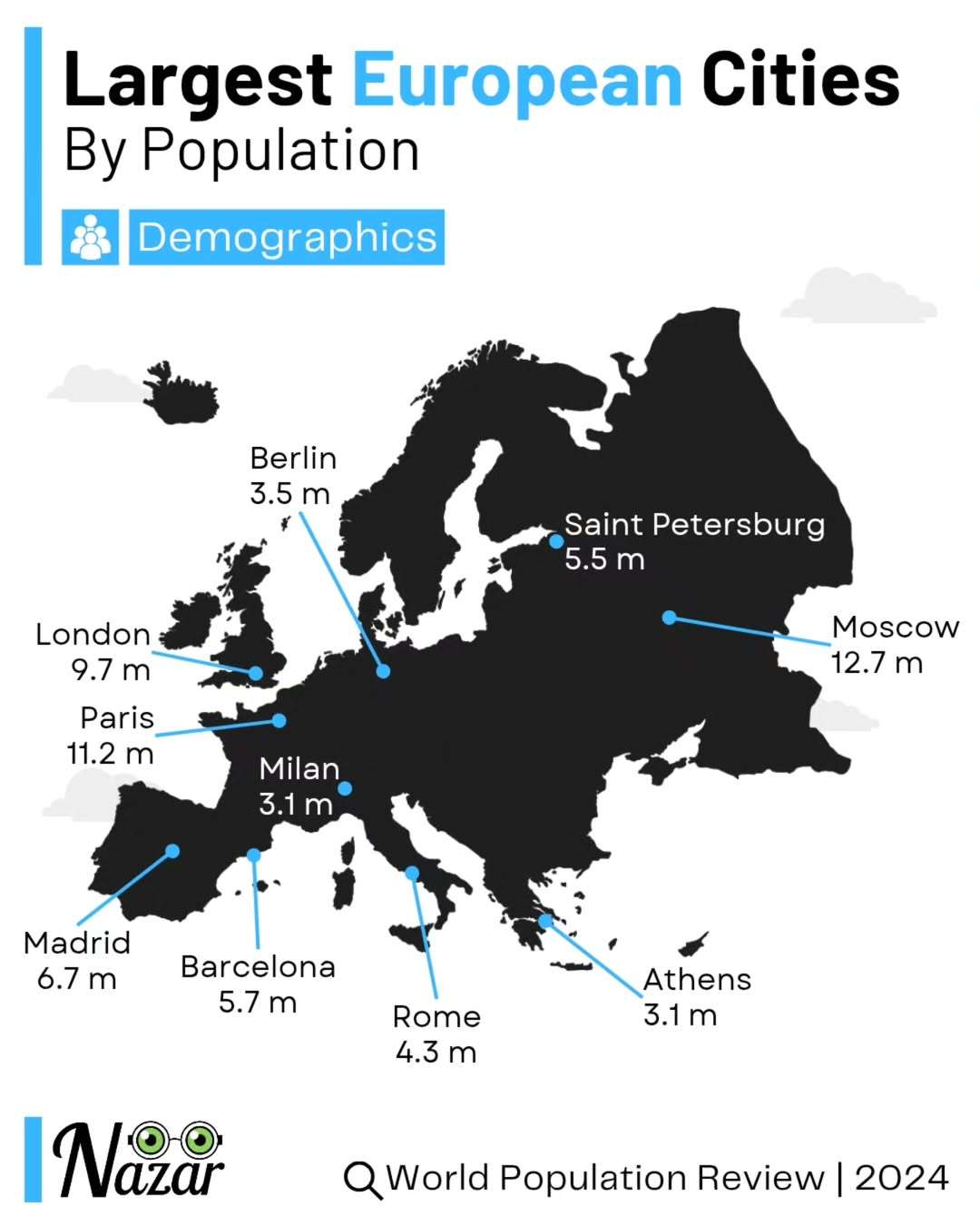
    Europe’s biggest cities by population

    author: nazar.data/instagram, added on: 2025-03-02

    Europe’s biggest cities by population


  • Registered Users, Registered Users 2 Posts: 24,294 ✭✭✭✭Esel
    Not Your Ornery Onager


    See the dot over the letter T ? That dot is represented by H in the new standard which came in later.

    Not your ornery onager


  • Registered Users, Registered Users 2 Posts: 31,771 ✭✭✭✭zell12


    the 1940s, which passenger ships from Corcaigh/Doire still? Anyone have a map of those liner routes and names?

    And look at those new cáblaí telegrafa! And why is Newry (An tIúr) called Iubar Cinn Trágha? zoomable

    image.png image.png


  • Advertisement
  • Registered Users, Registered Users 2 Posts: 73,851 ✭✭✭✭L1011


    I think it was Anchor from Derry to New York, and Burns Laird to Scotland.

    The Derry to New York ones used to pick Donegal passengers up, at sea, some distance North of Arranmore.

    For Cork - pretty much every British and some other lines did a final call at Cobh until the era when flights took over.

    Iubhar Chinn Trágha seems to be an obsolete name for Newry even then.


Advertisement