Advertisement
If you have a new account but are having problems posting or verifying your account, please email us on hello@boards.ie for help. Thanks :)
Hello all! Please ensure that you are posting a new thread or question in the appropriate forum. The Feedback forum is overwhelmed with questions that are having to be moved elsewhere. If you need help to verify your account contact hello@boards.ie

Interesting Maps

1240241243245246339

Comments

  • Moderators, Social & Fun Moderators Posts: 13,582 Mod ✭✭✭✭JupiterKid


    Thoms Directory map of Dublin city, 1890

    FB_IMG_1717346166949.jpg

    Dublin was a much smaller city of 375,000 at the time, most of whom lived in poverty in squalid slum conditions in the Georgian tenements and back lanes.

    The wealthy were moving out of the city, across the canal ring into the then new suburbs of Ballsbridge, Rathmines and Rathgar to escape the squalour and crime of the city. The built up area of Dublin extended out as far as Terenure by 1890.

    Note the separate townships for Drumcondra, Clontarf, Pembroke, Kilmainham and Rathmines - all of which were incorporated into Dublin city borough in 1930.


  • Registered Users, Registered Users 2 Posts: 78,723 ✭✭✭✭Victor


    @JupiterKid "Note the separate townships for Drumcondra, Clontarf, Pembroke, Kilmainham and Rathmines - all of which were incorporated into Dublin city borough in 1930." - Drumcondra, Clontarf and Kilmainham failed early on and were incorporated into the city. Only Pembroke and Rathmines lasted until 1930. Meanwhile, Blackrock, Kingstown, Dalkey and Killiney were merged into Dun Laoghaire Borough.


  • Moderators, Arts Moderators, Recreation & Hobbies Moderators, Social & Fun Moderators Posts: 78,215 Mod ✭✭✭✭New Home


    Untitled Image

    0_o


  • Registered Users, Registered Users 2 Posts: 3,175 ✭✭✭Bogwoppit


  • Registered Users, Registered Users 2 Posts: 472 ✭✭Mullinabreena


    I'm not sure how accurate this map from Energia is having Co. Sligo as the 6th highest in the amount of sunlight

    Irel_Energia2-Updated.jpg


  • Advertisement
  • Moderators, Recreation & Hobbies Moderators Posts: 22,651 Mod ✭✭✭✭Brian?


    1 or 2 days a week max for me. But everyone is different.

    My biggest problem working from home is taking breaks

    they/them/theirs


    The more you can increase fear of drugs and crime, welfare mothers, immigrants and aliens, the more you control all of the people.

    Noam Chomsky


  • Moderators, Arts Moderators, Recreation & Hobbies Moderators, Social & Fun Moderators Posts: 78,215 Mod ✭✭✭✭New Home


    You need to get yourself a pet. They'll make you take breaks whether you like it or not.


  • Registered Users, Registered Users 2 Posts: 1,767 ✭✭✭Asdfgh2020


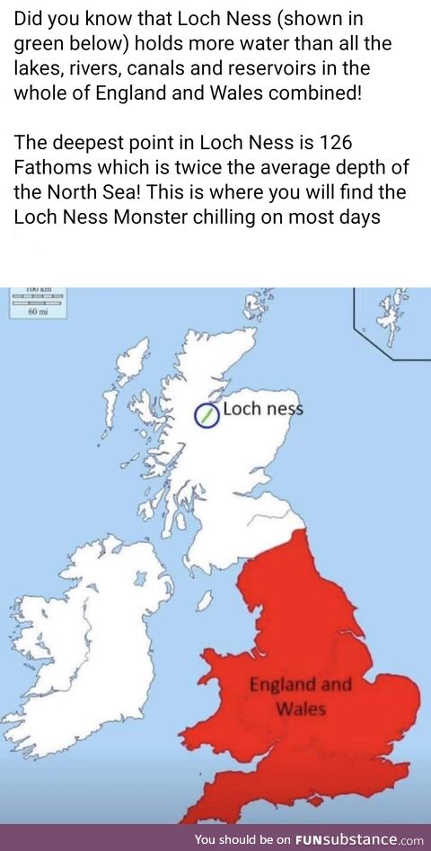
    think the claim that it contains more water than all the lakes, canals, reservoirs and rivers in all of uk is a total exaggeration / false. Lakes and canals maybe but not all rivers also….!


  • Moderators, Category Moderators, Arts Moderators, Sports Moderators Posts: 52,516 CMod ✭✭✭✭magicbastarder


    Adding the rivers to the mix probably won't change the calculation that much, unless the situation at a global level is a lot different to the one of the UK; the following is a global stat:

    The total volume of water in rivers is estimated at 2,120 km3 (510 cu mi), or 0.49% of the surface fresh water on Earth.[

    I.e., globally, you'd barely change the total calculation by excluding rivers.


  • Registered Users, Registered Users 2 Posts: 3,175 ✭✭✭Bogwoppit


    Rivers hold very little water, negligible amounts in the grand scheme.
    Most of the worlds lake are very shallow which means the ones with depth hold a disproportionately large volume by surface area.
    Loch Ness is quite deep in terms of UK lakes, it also has a relatively large surface area, so volumes are much larger than they appear on a simple map.
    An extreme example is Lake Baikal, it’s the 6th largest lake by surface area but it holds 20-25% of the worlds unfrozen freshwater. More than all the Great Lakes combined.


  • Advertisement
  • Registered Users, Registered Users 2 Posts: 4,909 ✭✭✭beggars_bush


    Depends on the location in Sligo too

    North of Sligo town would get more sunshine than eg Tubbercurry


  • Moderators, Category Moderators, Arts Moderators, Sports Moderators Posts: 52,516 CMod ✭✭✭✭magicbastarder


    i did a quick calculation there - if you emptied loch ness and refilled it with the shannon; assuming no outflow, it'd take the shannon about 14 months to refill it.


  • Registered Users, Registered Users 2 Posts: 472 ✭✭Mullinabreena


    Yeah there are a lot of geological factors that impact on sunshine. Coastal areas get more than places close to mountains. You can see the Ox Mountains get the least sunshine in Sligo

    sunshine_map.png


  • Registered Users, Registered Users 2 Posts: 16,778 ✭✭✭✭cj maxx


    And Lake Baikal is still getting wider and deeper . It’s on an active rift which is getting deeper by about an inch per year


  • Moderators, Recreation & Hobbies Moderators Posts: 22,651 Mod ✭✭✭✭Brian?


    I have a dog I walked at lunchtime. But because I don’t always work from home he goes with a walker 2 days a week. So those days I sit in front of the laptop for 9 hours

    they/them/theirs


    The more you can increase fear of drugs and crime, welfare mothers, immigrants and aliens, the more you control all of the people.

    Noam Chomsky


  • Registered Users, Registered Users 2 Posts: 11,104 ✭✭✭✭Realt Dearg Sec


    dublin-2-18052016.jpg screen-shot-2013-02-22-at-16-00-02.png

    These from Patrick Abercrombie (1922), Dublin of the Future. It was a plan to redesign Dublin to both cope with anticipated expansion and to make it more reflective of the ideals of the newly independent state. It won a competition towards that end, and the whole plan is one of the most remarkable books in Irish architectural and planning history.

    The most obvious change he purposes here is to move the center of the city to Capel Street, and the idea was that this would be transformed into a very wide boulevard with large monumental buildings at either end, with the city's tram system radiating outwards from there. He also proposed new developments at Crumlin and Marino, and the creation of a radial traffic system with a serious of large spokes emanating from the center of the city outwards.

    It's a really amazing book. It's heavily influenced by the transformation of Paris by Haussmann in the 19th century. While the Wide Streets Commission in Dublin had carried out some limited improvements to the city, the general idea of a more general recreation of the streetscape along rational lines with widened boulevard and monumental buildings was very much in fashion at this time.

    Abercrombies plan, though, was originally conceived BEFORE the Rising, War of Independence, and Civil War, and he made some adjustments to it in the aftermath. Most notably, he describes the destruction of the city in this period both in terms of the kind of evil that results from a lack of rational planning, and as an opportunity, where areas of the city were now a tabula rasa to create that more rational city (and also to occupy its workers in doing something positive).


  • Registered Users, Registered Users 2 Posts: 914 ✭✭✭MICKEYG


    So the days you can't walk the dog, because I assume you are not at home (and thus in the office?), are the days you stay at the computer for 9 hours. So WFH is not the problem?


  • Moderators, Recreation & Hobbies Moderators Posts: 22,651 Mod ✭✭✭✭Brian?


    maybe I wrote it wrong.

    If I work at the office I wander around on off for the day. Coffee machine, canteen etc.

    If I work from home and don’t have to walk the dog. I eat lunch etc in front of the laptop. No moving between meeting rooms

    they/them/theirs


    The more you can increase fear of drugs and crime, welfare mothers, immigrants and aliens, the more you control all of the people.

    Noam Chomsky


  • Registered Users, Registered Users 2 Posts: 2,916 ✭✭✭PommieBast


    For me fully remote is just too close to the trauma of being cooped up in an undersized central Dublin apartment during Covid. Made worse because my then-job required a lot more than just a workstation. My usual place of work has to be somewhere I don't live.


  • Registered Users, Registered Users 2 Posts: 4,574 ✭✭✭KevRossi


    Abercrombie was a fan of Green Belts. One of his ideas, a linear park along the Dodder has been more or less implemented, but not to the extent that he had planned.


  • Advertisement
  • Registered Users, Registered Users 2 Posts: 16,778 ✭✭✭✭cj maxx


    Map

    image.png

    the now defunct Great Northern Railway in 1926 . Shortsightedness on both sides to close it down to protect their ‘ countries ‘

    Post edited by cj maxx on


  • Registered Users, Registered Users 2 Posts: 78,723 ✭✭✭✭Victor


  • Registered Users, Registered Users 2 Posts: 16,778 ✭✭✭✭cj maxx


    I edited it and reposted with my android phone and the map shows on it . It’s also showing on iPhone so maybe refresh the page ?


  • Registered Users, Registered Users 2 Posts: 78,723 ✭✭✭✭Victor


    The map is a map of the Great Northern Railway in England, extending from London to Liverpool and York. What countries (sic) are you talking about?

    Better version of map.

    Untitled Image


  • Registered Users, Registered Users 2 Posts: 6,968 ✭✭✭Badly Drunk Boy


    I think this is should have been cj maxx's map, the countries being the UK and Ireland:

    image.png


  • Registered Users, Registered Users 2 Posts: 16,778 ✭✭✭✭cj maxx


    That was the one in the original link . Why maps don’t show on my iPhone posts but do on android. I’ll find what I’m doing wrong . Cheers


  • Moderators, Society & Culture Moderators Posts: 16,900 Mod ✭✭✭✭Manic Moran


    Related. 2018 rail tonnage.

    STB_2018_PublicMap_022620.png

    Put all three surface modes together

    jnuj2uz7j9h81.png


  • Registered Users, Registered Users 2 Posts: 14,780 ✭✭✭✭josip


    What's the reason for the blue (>100) in the Rail Map? Is it grain?

    And does it all go to Kansas or somewhere else? But what happens when it gets there? Even if that product was processed, wouldn't it show up on some other map (eg road) by weight? I thought that the routes with the greatest tonnage would terminate at the coast/great lakes/Mississippi.

    Apologies for all the questions, I drove across the Great Plains years ago and I've been curious about the area since.


  • Registered Users, Registered Users 2 Posts: 1,281 ✭✭✭Busman Paddy Lasty


    Maybe coal to supply a power station? Commodity being turned into pollution :(


  • Advertisement
  • Registered Users, Registered Users 2 Posts: 7,922 ✭✭✭GerardKeating


    Blue is "inland waterway" mainly the Mississippi River


Advertisement