Advertisement
If you have a new account but are having problems posting or verifying your account, please email us on hello@boards.ie for help. Thanks :)
Hello all! Please ensure that you are posting a new thread or question in the appropriate forum. The Feedback forum is overwhelmed with questions that are having to be moved elsewhere. If you need help to verify your account contact hello@boards.ie

Interesting Maps

1212213215217218339

Comments

  • Registered Users, Registered Users 2 Posts: 3,516 ✭✭✭davetherave


    Colon, the city on the Atlantic side is further West than Panama City, the city on the Pacific Side. Going from the Atlantic to the Pacific you are travelling down and right (South and West). Panama is a left-right horizontal country, rather than an up/down vertical country.


    image.png


  • Registered Users, Registered Users 2 Posts: 4,372 ✭✭✭chooseusername


    Down and Right would be South and East surely !


  • Registered Users, Registered Users 2 Posts: 43,313 ✭✭✭✭K-9


    Water levels are down 30-40% on the usual levels in the Panama Canal due to drought conditions for the last 18 months or so. It's having a big affect on shipping levels.

    Between it and the Suez, it shows how dependent we still are on them.

    Mad Men's Don Draper : What you call love was invented by guys like me, to sell nylons.


  • Registered Users, Registered Users 2 Posts: 30,500 ✭✭✭✭zell12


    The Atlantic portal is further west than the Pacific portal!


  • Moderators, Recreation & Hobbies Moderators Posts: 22,705 Mod ✭✭✭✭Brian?


    I saw this on Reddit, I’m not normally into stuff like this but it made me chuckle. It’s 100% accurate.

    IMG_5829.jpeg


    they/them/theirs


    The more you can increase fear of drugs and crime, welfare mothers, immigrants and aliens, the more you control all of the people.

    Noam Chomsky


  • Advertisement
  • Moderators, Social & Fun Moderators Posts: 13,587 Mod ✭✭✭✭JupiterKid


    Geological map of Great Britain, circa 1910

    FB_IMG_1705779811067.jpg


  • Moderators, Social & Fun Moderators Posts: 13,587 Mod ✭✭✭✭JupiterKid


    Relief map of Egypt, with the Nile Valley cutting through the desert plateau clearly visible.

    FB_IMG_1704762795175.jpg


  • Moderators, Social & Fun Moderators Posts: 13,587 Mod ✭✭✭✭JupiterKid


    Probable extent of the ancient Kingdom of Babylon, 1,750 BC.

    FB_IMG_1705862334492.jpg


  • Registered Users, Registered Users 2 Posts: 16,831 ✭✭✭✭cj maxx


  • Registered Users, Registered Users 2 Posts: 11,108 ✭✭✭✭Realt Dearg Sec


    To answer that question we'll need another three pages about the British isles


  • Advertisement
  • Registered Users, Registered Users 2 Posts: 16,831 ✭✭✭✭cj maxx


  • Moderators, Recreation & Hobbies Moderators, Science, Health & Environment Moderators, Technology & Internet Moderators Posts: 95,142 Mod ✭✭✭✭Capt'n Midnight


    image.png

    .

    image.png

    .

    image.png


  • Moderators, Politics Moderators Posts: 43,052 Mod ✭✭✭✭Seth Brundle


    Not sure on the accuracy of this but...

    image.png

    If this is correct then I'm surprised that the bottom 80% of people in the UK own the wealth.


  • Moderators, Social & Fun Moderators Posts: 13,587 Mod ✭✭✭✭JupiterKid


    These juxtaposed maps really show just how small - and densely populated - Gaza is (or was).


  • Registered Users, Registered Users 2 Posts: 43,313 ✭✭✭✭K-9


    I'd be amazed the UK would be green, I might look into that at some stage.

    Mad Men's Don Draper : What you call love was invented by guys like me, to sell nylons.


  • Registered Users, Registered Users 2 Posts: 30,500 ✭✭✭✭zell12


  • Registered Users, Registered Users 2 Posts: 473 ✭✭Mullinabreena


    Blue eyes map of Europe

    map-of-the-percentage-with-light-eyes-in-european-v0-1ikuearfctb91.png


  • Registered Users, Registered Users 2 Posts: 27,548 ✭✭✭✭Peregrinus


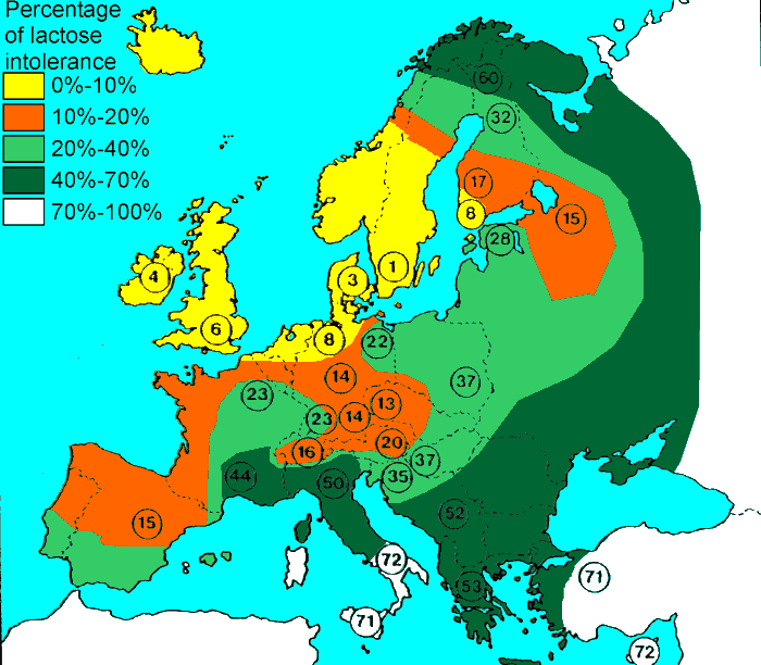
    Frequency of blue eyes is strikingly similar to frequence of lactose tolerance:


    Untitled Image


  • Registered Users, Registered Users 2 Posts: 2,805 ✭✭✭kowloonkev


    Isn't a lot of the wealth in the UK owned by non-UK people? Would those people be included in the 1%, or citizens only?


  • Registered Users, Registered Users 2 Posts: 27,548 ✭✭✭✭Peregrinus


    Statistics like this are usually done on the basis of residence, not citizenship. So, of all the wealth held by UK residents, you compare the wealth held by the top 1% and the bottom 8%. Wealth owned by non-residents is omitted from the calculation.

    You ignore citizenship. (Typically, in fact, the data sources on income and household wealth won't have recorded citizenship, so even if you wanted to do this on the basis of citizenship it would a difficult statistic to assemble.)

    And, just to add, we could be looking at this on the basis of individuals, or on the basis of households — i.e we could be looking at a claim about the wealthiest 1% of UK individuals, or the wealthiest 1% of UK households.


  • Advertisement
  • Registered Users, Registered Users 2 Posts: 5,634 ✭✭✭silliussoddius


    If farming spread from the Levant, wouldn’t you expect people there to have high levels of lactose tolerance?


  • Registered Users, Registered Users 2 Posts: 27,548 ✭✭✭✭Peregrinus


    Not unless they were practising dairy farming. Which - oversimplification coming - they would only do if they were lactose-tolerant.

    Human infants and children generally have no problem with lactose (which is fortunate, given how we nourish our infants) but the lactose-intolerant tend to lose the capacity to digest it in adulthood. If you don't lose it in adulthood, that's because you have genes which give you the enduring ability to digest lactose. Natural selection will favour these genes in a population that lives in an environment where a limited inability to lactose is going to unduly restrict your diet — the lactose-tolerant will be better nourished, enjoy better health, live longer, have more children, so with each generation the proportion of the population that has the lactose-tolerant gene rise.

    So, in a Mediterranean region, you can get dietary fat from olives, calcium from almonds, figs, seeds, fish, etc; you'll do just fine without much dairy in your diet. Whereas if you live in, say, Norway, there aren't a lot of olives, almonds or figs to be had, and milk and butter are quite important. So the lactose-tolerant have an evolutionary advantage in Norway that they don't have in Sicily.

    (In fact lactose-intolerant people can eat dairy foods, but they will generally process them first to reduce the amount of lactose in them, e.g. by fermentation. So lactose intolerant populations do practice dairy farming, partly to produce food for their lactose-tolerant children but also to produce processed dairy foods that adults in the community can consume.)


  • Moderators, Recreation & Hobbies Moderators Posts: 22,705 Mod ✭✭✭✭Brian?


    I assume they drank more goat milk than cows milk to be honest. They farmed wheat etc. but I’m not sure how many cows they had.

    they/them/theirs


    The more you can increase fear of drugs and crime, welfare mothers, immigrants and aliens, the more you control all of the people.

    Noam Chomsky


  • Registered Users, Registered Users 2 Posts: 5,634 ✭✭✭silliussoddius


    Then again you can always eat the animals, instead of drinking the milk.


  • Registered Users, Registered Users 2 Posts: 27,548 ✭✭✭✭Peregrinus


    Cattle were central to the ancient farming economy in the Levant. They were highly prized, and often served as a proxy for wealth generally. But they were used mainly as beast of burden. In that capacity, they were far too valuable to be slaughtered for food, except as an act of conspicuous consumption by the very wealthy. So, outside of royal banquets and the like, beef was rarely eaten.

    They weren't kept for dairy purposes, because most people were lactose-intolerant and because, anyway, they were far more useful drawing carts and ploughs. They didn't have any dairy breeds of cattle, so cows only gave milk when they actually had a calf to suckle. No doubt there would have been some surplus milk - e.g. when a calf dies prematurely - and possibly some of that was processed into cheese.

    They did use goats for dairy purposes, but goat's milk also contains lactose - all mammalian milk does - so not a lot of goat's milk would have been consumed by adults.

    To the extent that lactose-intolerance is genetic, you can't overcome lactose intolerance by accustoming yourself to regular consumption of milk — your diet won't change your genes.


  • Registered Users, Registered Users 2 Posts: 473 ✭✭Mullinabreena


    main-qimg-1ce4f0a39a4c53765e2a78d4d5f6ab3c-lq.jpeg

    Red hair map of Europe.

    People with red hair and blue eyes are only 0.17% of the worlds population.


  • Moderators, Category Moderators, Arts Moderators, Sports Moderators Posts: 52,664 CMod ✭✭✭✭magicbastarder


  • Registered Users, Registered Users 2 Posts: 5,634 ✭✭✭silliussoddius


    At a later date they also became very important: the word chattel has a similar origin to cattle, in Ireland you have the cattle raiding/rustling stories and Boru (from a certain king) means cattle tribute.


  • Moderators, Recreation & Hobbies Moderators, Science, Health & Environment Moderators, Technology & Internet Moderators Posts: 95,142 Mod ✭✭✭✭Capt'n Midnight


    image.png

    Map showing the 'General direction taken by Meave's forces in the Táin bó Cuailgne' from Eleanor Hull's The Cuchullin Saga in Irish Literature (1898, frontispiece). The map was 'drawn up' by Standish Hayes O'Grady (ibid., lxxix) and is the earliest published cartographic depiction of the route. While it shows little appreciation of the complexities of the journey through Cooley, Co. Louth, it does include specific detail of the raid on Dunseverick on the north Antrim coast. It also depicts a looped section in the Strokestown/Longford area on the outward journey and a striking zig-zag diversion in mid-Louth on the homeward route.

    https://www.researchgate.net/figure/Map-showing-the-General-direction-taken-by-Meaves-forces-in-the-Tain-bo-Cuailgne-from_fig2_325011589


  • Advertisement
  • Registered Users, Registered Users 2 Posts: 5,634 ✭✭✭silliussoddius


    I had read about a hypothesis that the Rathcroghan area in the midlands is very important and that the UiNiall made Tara more prominent to suit them, so you have the weird midlands route.


Advertisement