Advertisement
If you have a new account but are having problems posting or verifying your account, please email us on hello@boards.ie for help. Thanks :)
Hello all! Please ensure that you are posting a new thread or question in the appropriate forum. The Feedback forum is overwhelmed with questions that are having to be moved elsewhere. If you need help to verify your account contact hello@boards.ie

Interesting Maps

17071737576336

Comments

  • Registered Users, Registered Users 2 Posts: 14,394 ✭✭✭✭Professor Moriarty


    i assume the presence of a monarchy and/or the lack of a written constitution would be significant in ireland scoring higher than the UK?

    Add in FPTP plus the House of Lords.


  • Registered Users, Registered Users 2 Posts: 2,511 ✭✭✭Purgative


    i assume the presence of a monarchy and/or the lack of a written constitution would be significant in ireland scoring higher than the UK?


    Yeah I took it as PR over FPTP


  • Posts: 18,749 ✭✭✭✭ [Deleted User]


    cnocbui wrote: »
    They must have some pretty weird criteria to rate Swizerland as being less democratic than a host of others which I would rate as less democratic.

    Their democracy is so stroong the 'people' even manged the almost impossible, these days, of giving the collective finger to political correctness and banned the building of minarets attached to mosques, much to the chagrin and collective embarrasment of their politicians.

    Dunno why banning minarets is a sign of democracy


  • Registered Users, Registered Users 2 Posts: 2,511 ✭✭✭Purgative


    bubblypop wrote: »
    Dunno why banning minarets is a sign of democracy


    Surely the more decisions that go against what the executive is trying to do, indicates an effective democracy. Like the Maastricht Treaty vote, and the opposite to what is happening in the UK - e.g. "Here's a deal, its great, you can't read and the Tory majority will carry it whatever".


  • Moderators, Category Moderators, Arts Moderators, Sports Moderators Posts: 52,403 CMod ✭✭✭✭magicbastarder


    might be worth dropping the political discussion, this is probably not the right thread for it?


  • Advertisement
  • Moderators, Social & Fun Moderators, Sports Moderators Posts: 56,353 Mod ✭✭✭✭Necro


    Mod:

    Back on topic folks, let's keep this light hearted :)


  • Registered Users, Registered Users 2 Posts: 3,862 ✭✭✭mikhail


    upupup wrote: »
    ...no mention of the native americans
    I would guess their languages are most closely related to Sino-Tibetan languages, but I haven't ready anything about them.
    IAMAMORON wrote: »
    It is a hypothetical summary of language development transposed onto a tree.

    Get over it.

    I like it btw, but I would not be drawing any assumptions from it either.

    Where is Mandarin and Cantonese? Are they on the same tree or what?
    No, it's a eurocentric map: those trees refer only to the biggest language groups in Europe. There's nothing on Sino-Tibetan (~east Asia) or Bantu languages (~central Africa), which would be on the same scale as Proto-Indo-European.


  • Registered Users, Registered Users 2 Posts: 3,862 ✭✭✭mikhail


    Here are a couple of maps of modern day language groups.
    Primary_Human_Languages_Improved_Version.png

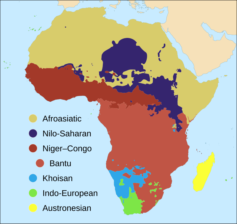
    This one focusses primarily on Africa:
    800px-Map_of_African_language_families.svg.png

    Inevitably, the reality is a bit messier than gets captured on any one map, but I find them interesting all the same. They're somehow a fossil record of ancient migration, trade and conquest. For example, Bantu is a language group deeply rooted in the rise and spread of a set of tool-making and agricultural practices in central Africa a few thousand years ago. It's basically sub-Saharan Africa's entry into the iron age.


  • Registered Users, Registered Users 2 Posts: 9,140 ✭✭✭Gregor Samsa


    Map of the many languages of Dagestan, a republic in the North Caucasian Federal District of Russia, only 59% the size of Ireland and with a population of only 3 million.

    542528.png


  • Registered Users, Registered Users 2 Posts: 524 ✭✭✭richardjjd


    Reading 'The Atlas of Unusual Borders' by Zoran Nikolic at the moment. In a chapter on quadripoints, the following appears. Anyone know where the ten-point multipoint is in Ireland?


  • Advertisement
  • Registered Users, Registered Users 2 Posts: 5,554 ✭✭✭silliussoddius


    Map of the many languages of Dagestan, a republic in the North Caucasian Federal District of Russia, only 59% the size of Ireland and with a population of only 3 million.

    542528.png

    Mountainous regions tend to have a variety of languages. Papua New Guinea has almost one third of the world’s languages.
    https://en.m.wikipedia.org/wiki/Papuan_languages


  • Registered Users, Registered Users 2 Posts: 78,709 ✭✭✭✭Victor


    richardjjd wrote: »
    Reading 'The Atlas of Unusual Borders' by Zoran Nikolic at the moment. In a chapter on quadripoints, the following appears. Anyone know where the ten-point multipoint is in Ireland?

    There is a pattern of groups of townlands all meeting together in the middle of bogs. Ironically, it is much less likely in lakes, which tend not to have more than three-four townlands meeting together.


  • Registered Users, Registered Users 2 Posts: 9,140 ✭✭✭Gregor Samsa


    richardjjd wrote: »
    Reading 'The Atlas of Unusual Borders' by Zoran Nikolic at the moment. In a chapter on quadripoints, the following appears. Anyone know where the ten-point multipoint is in Ireland?


    "In Northern Ireland, ten townlands meet at the summit of Knocklayd (clearly shown by Ordnance Survey mapping at point 311518 436392). The townlands are, clockwise from north, Broom-More, Tavnaghboy, Kilrobert, Clare Mountain, Aghaleck, Corvally, Essan, Cleggan, Stroan, and Tullaghore."

    https://en.wikipedia.org/wiki/Quadripoint#Multipoints_of_greater_numerical_complexity


    Here's a map showing the borders of the 10 townlands converging at the summit.

    542761.png


    Source: https://www.openstreetmap.org/relation/4280513#map=14/55.1574/-6.2286&layers=H


    If Tullaghore and Stroan weren't so greedy as to hog the whole western portion of the mountain, they would have got another 7 townlands in.


  • Registered Users, Registered Users 2 Posts: 18,854 ✭✭✭✭silverharp


    A belief in gender identity involves a level of faith as there is nothing tangible to prove its existence which, as something divorced from the physical body, is similar to the idea of a soul. - Colette Colfer


  • Registered Users, Registered Users 2 Posts: 524 ✭✭✭richardjjd


    If Tullaghore and Stroan weren't so greedy as to hog the whole western portion of the mountain, they would have got another 7 townlands in.

    Their behaviour is shocking.

    Thanks for that @Gregor - interesting read.


  • Moderators, Recreation & Hobbies Moderators, Science, Health & Environment Moderators, Technology & Internet Moderators Posts: 94,897 Mod ✭✭✭✭Capt'n Midnight


  • Moderators, Recreation & Hobbies Moderators, Science, Health & Environment Moderators, Technology & Internet Moderators Posts: 94,897 Mod ✭✭✭✭Capt'n Midnight


  • Moderators, Recreation & Hobbies Moderators, Science, Health & Environment Moderators, Technology & Internet Moderators Posts: 94,897 Mod ✭✭✭✭Capt'n Midnight


    50AmuD5.jpeg

    comments
    Is the red in north/south Dakota and mn native american reservations?
    Yes. Also correlates with red spots in MT, AZ, and WY
    Also corresponds with the primarily-Alaska Native villages in AK
    Poor Blacks in the South, poor Whites in Appalachia, and poor Native Americans on reservations. This is a map of poverty.


  • Registered Users, Registered Users 2 Posts: 21,025 ✭✭✭✭cnocbui


    silverharp wrote: »

    As senior marketing manager of a major condom manufacturer, looking for markets to expand into, I thank you.


  • Registered Users, Registered Users 2 Posts: 14,936 ✭✭✭✭retalivity


    This is a map of poverty.

    Also closely mirrors voter loyalty, with the people dying younger voting for the rich mans party against universal healthcare.
    Go figure.


  • Advertisement
  • Registered Users, Registered Users 2 Posts: 2,101 ✭✭✭I see sheep


    544023.PNG

    "a terrible war imposed by the provisional IRA"

    Our West Brit Taoiseach


  • Registered Users, Registered Users 2 Posts: 11,647 ✭✭✭✭El Weirdo


    544023.PNG

    I've found an error!


  • Registered Users, Registered Users 2 Posts: 23,032 ✭✭✭✭Tell me how


    El Weirdo wrote: »
    I've found an error!

    Are you sure? Looks ok to me.


  • Posts: 13,688 ✭✭✭✭ Edison Late Hermit


    Are you sure? Looks ok to me.

    And me.

    22 teams have won it, 22 teams are on the map.


  • Registered Users, Registered Users 2 Posts: 9,140 ✭✭✭Gregor Samsa


    Are you sure? Looks ok to me.

    I know nothing about soccerball.

    But there are errors in the map. Balearic Islands should be coloured light blue as part of Spain. Same with Sardinia (Italy) and Corsica (France).


  • Registered Users, Registered Users 2 Posts: 14,752 ✭✭✭✭josip


    Some might also say that Wales should not be coloured the same as England or Scotland since they have a separate soccer federation.

    Also, when Red Star won it, it was part of Jugoslavija, not just Serbia.
    Ed. Of the starting 11 in the final in 1991, the players per country (of birth) breakdown was:

    Montenegro 3
    Serbia 3
    Macedonia 2
    Croatia 2
    Romania 1


    and one of the subs was from Bosnia.


  • Registered Users, Registered Users 2 Posts: 5,734 ✭✭✭Duckworth_Luas


    El Weirdo wrote: »
    I've found an error!
    Not a soccer fan, but I believe the logo of the Romanian team is incorrect?

    There was some type of split situation with Steau Bucharest, the army team, who won in late 80s.

    That logo is for a new team, FCSB, while the original club that were Euro champs also still exist.


  • Registered Users, Registered Users 2 Posts: 23,032 ✭✭✭✭Tell me how


    I know nothing about soccerball.

    But there are errors in the map. Balearic Islands should be coloured light blue as part of Spain. Same with Sardinia (Italy) and Corsica (France).

    I'm speaking purely from the football perspective. There's a lot wrong from a cartography angle.


  • Registered Users, Registered Users 2 Posts: 3,492 ✭✭✭fergiesfolly


    El Weirdo wrote: »
    I've found an error!

    Marseilles European Cup was rescinded due to match fixing.


  • Advertisement
  • Registered Users, Registered Users 2 Posts: 3,061 ✭✭✭Suckler


    Marseilles European Cup was rescinded due to match fixing.

    Was it not their league cup that was rescinded or both European & league win?


Advertisement