Advertisement
If you have a new account but are having problems posting or verifying your account, please email us on hello@boards.ie for help. Thanks :)
Hello all! Please ensure that you are posting a new thread or question in the appropriate forum. The Feedback forum is overwhelmed with questions that are having to be moved elsewhere. If you need help to verify your account contact hello@boards.ie
Hi there,
There is an issue with role permissions that is being worked on at the moment.
If you are having trouble with access or permissions on regional forums please post here to get access: https://www.boards.ie/discussion/2058365403/you-do-not-have-permission-for-that#latest

RITA (Eighteen)

Comments

  • Registered Users, Registered Users 2 Posts: 11,134 ✭✭✭✭maquiladora


    Might be a CAT 1 danger to the Florida Keys and Cuba, then later with very warm waters in the Gulf, a chance to intensify to Cat 3/4 and make landfall on the Texas coast. Could be nasty....
    And yeah, flying through the names! We could see a Hurricane Alpha yet...


  • Registered Users, Registered Users 2 Posts: 12,811 ✭✭✭✭billy the squid


    indeed with regard to the names Stan is looking likely over the next few days also, keep an eye out for that one also.


  • Registered Users, Registered Users 2 Posts: 12,811 ✭✭✭✭billy the squid


    Hurricane watches for the Florida Keys have been upgraded to hurricane warnings.

    Hurricane watches on the souther tip of eastern florida have been upgraded to a tropical storm warning and hurricane watch.

    Radar - Miami Florida
    http://radar.weather.gov/radar/latest/DS.p20-r/si.kamx.shtml

    Radar - Key West Florida
    http://radar.weather.gov/radar/latest/DS.p20-r/si.kbyx.shtml

    updated...
    000
    WTNT63 KNHC 190511
    TCUAT3
    TROPICAL STORM RITA TROPICAL CYCLONE UPDATE
    NWS TPC/NATIONAL HURRICANE CENTER MIAMI FL
    115 AM EDT MON SEP 19 2005
    AT 2 AM EDT...0600Z...THE GOVERNMENT OF THE BAHAMAS HAS ISSUED A
    HURRICANE WARNING FOR THE NORTHWESTERN BAHAMAS...EXCLUDING GRAND
    BAHAMA AND THE ABACOS. THE GOVERNMENT OF THE BAHAMAS HAS ISSUED A
    TROPICAL STORM WARNING FOR GRAND BAHAMA AND THE ABACOS.

    FORECASTER FRANKLIN


  • Closed Accounts Posts: 14,483 ✭✭✭✭daveirl


    This post has been deleted.


  • Registered Users, Registered Users 2 Posts: 12,811 ✭✭✭✭billy the squid


    daveirl wrote:
    This post has been deleted.

    there are ten weeks left in the season. anything could happen in that length of time.


  • Advertisement
  • Registered Users, Registered Users 2 Posts: 12,811 ✭✭✭✭billy the squid


    just a quick note that nbc6 has started its streaming coverage for anyone who is interested. it may not work with dial up connections

    http://mfile.akamai.com/12908/live/reflector:35252.asx


  • Registered Users, Registered Users 2 Posts: 879 ✭✭✭sirpsycho


    000
    Wtnt63 Knhc 201311
    Tcuat3
    hurricane Rita Tropical Cyclone Update
    Nws Tpc/national Hurricane Center Miami Fl
    915 Am Edt Tue Sep 20 2005

    Doppler Radar Data...satellite Presentation And Pressure Falls From
    The Reconnaissance Aircraft Indicate That Rita Has Reached Category
    One Hurricane Strength On The Saffir/simpson Hurricane Scale. This
    Will Be Reflected On The 11 Am...1500z Advisory.

    Forecaster Avila


  • Registered Users, Registered Users 2 Posts: 879 ✭✭✭sirpsycho


  • Closed Accounts Posts: 14,483 ✭✭✭✭daveirl


    This post has been deleted.


  • Registered Users, Registered Users 2 Posts: 12,811 ✭✭✭✭billy the squid


    000
    WTNT63 KNHC 202131
    TCUAT3
    HURRICANE RITA TROPICAL CYCLONE UPDATE
    NWS TPC/NATIONAL HURRICANE CENTER MIAMI FL
    530 PM EDT TUE SEP 20 2005

    BETWEEN 445 AND 5 PM EDT...AN UNOFFICIAL REPORT FROM A HAM RADIO
    OPERATOR INDICATED SUSTAINED WINDS OF 75 MPH WITH GUSTS TO 102 MPH
    WERE MEASURED BY WIND EQUIPMENT IN THE KEY WEST AREA.

    FORECASTER STEWART

    .


  • Advertisement
  • Registered Users, Registered Users 2 Posts: 12,811 ✭✭✭✭billy the squid


    Rita is now 1mph shy of being category 3

    Most likely landfall at this time is North eastern Texas

    Radar - Houston Texas
    http://radar.weather.gov/radar/latest/DS.p20-r/si.khgx.shtml

    also good radar image of the eye here
    http://radar.weather.gov/radar/latest/DS.p20-r/si.kbyx.shtml
    key west florida radar.

    update: as of the 06z advisory rita is now Category 3

    media link KTRH Radio Houston Texas
    http://www.ktrh.com/main.html


  • Registered Users, Registered Users 2 Posts: 879 ✭✭✭sirpsycho


    Good satellite loop here:

    http://www.ssec.wisc.edu/data/us_comp/us_comp.html
    000
    WTNT33 KNHC 210832
    TCPAT3
    BULLETIN
    HURRICANE RITA ADVISORY NUMBER 15
    NWS TPC/NATIONAL HURRICANE CENTER MIAMI FL
    5 AM EDT WED SEP 21 2005

    ...MAJOR CATEGORY THREE RITA MOVING INTO THE SOUTHEASTERN GULF OF
    MEXICO AND CONTINUING TO STRENGTHEN...

    AT 5 AM EDT...0900Z...THE TROPICAL STORM WARNING FOR PORTIONS OF THE
    FLORIDA KEYS IS DISCONTINUED EAST OF THE MARQUESAS KEYS...INCLUDING
    KEY WEST. A TROPICAL STORM WARNING REMAINS IN EFFECT FOR THE
    FLORIDA KEYS FROM THE MARQUESAS KEYS WESTWARD TO THE DRY TORTUGAS.

    INTERESTS IN THE NORTHWESTERN GULF OF MEXICO SHOULD MONITOR THE
    PROGRESS OF RITA.

    FOR STORM INFORMATION SPECIFIC TO YOUR AREA...INCLUDING POSSIBLE
    INLAND WATCHES AND WARNINGS...PLEASE MONITOR PRODUCTS ISSUED
    BY YOUR LOCAL WEATHER OFFICE.

    AT 5 AM EDT...0900Z...THE CENTER OF HURRICANE RITA WAS LOCATED NEAR
    LATITUDE 24.3 NORTH...LONGITUDE 84.6 WEST OR ABOUT 175 MILES...
    285 KM...WEST OF KEY WEST FLORIDA AND ABOUT 160 MILES... 255 KM...
    WEST-NORTHWEST OF HAVANA CUBA.

    RITA IS MOVING TOWARD THE WEST NEAR 14 MPH...22 KM/HR...AND THIS
    GENERAL MOTION IS EXPECTED TO CONTINUE FOR THE NEXT 24 HOURS. THIS
    MOTION SHOULD BRING THE CENTER OF RITA FARTHER AWAY FROM THE
    FLORIDA KEYS OVER THE SOUTHEASTERN GULF OF MEXICO TODAY.

    MAXIMUM SUSTAINED WINDS HAVE INCREASED TO NEAR 120 MPH...195
    KM/HR...WITH HIGHER GUSTS. RITA IS A CATEGORY THREE HURRICANE ON
    THE SAFFIR-SIMPSON SCALE. STRENGTHENING IS FORECAST DURING THE
    NEXT 24 HOURS...AND RITA IS EXPECTED TO BECOME A CATEGORY FOUR
    HURRICANE SOMETIME LATER TODAY.

    HURRICANE FORCE WINDS EXTEND OUTWARD UP TO 45 MILES... 75 KM...
    FROM THE CENTER...AND TROPICAL STORM FORCE WINDS EXTEND OUTWARD UP
    TO 140 MILES...220 KM.

    ESTIMATED MINIMUM CENTRAL PRESSURE IS 956 MB...28.23 INCHES.

    COASTAL STORM SURGE FLOODING OF 4 TO 6 FT ABOVE NORMAL TIDE LEVELS
    IS POSSIBLE IN THE TROPICAL STORM WARNING AREA. STORM SURGE
    FLOODING ELSEWHERE IN THE FLORIDA KEYS AND SOUTH FLORIDA SHOULD
    SUBSIDE TODAY.

    RITA IS EXPECTED TO PRODUCE ADDITIONAL RAINFALL ACCUMULATIONS OF 1
    TO 3 INCHES OVER EXTREME SOUTHERN FLORIDA AND THE FLORIDA KEYS.
    RAINFALL AMOUNTS OF 3 TO 5 INCHES...WITH MAXIMUM AMOUNTS OF 10
    INCHES OVER THE HIGHER ELEVATIONS...ARE POSSIBLE OVER NORTHWEST
    CUBA. RAINFALL AMOUNTS OF 1 TO 3 INCHES ARE POSSIBLE OVER THE
    NORTHERN YUCATAN PENINSULA.

    REPEATING THE 5 AM EDT POSITION...24.3 N... 84.6 W. MOVEMENT
    TOWARD...WEST NEAR 14 MPH. MAXIMUM SUSTAINED
    WINDS...120 MPH. MINIMUM CENTRAL PRESSURE... 956 MB.

    AN INTERMEDIATE ADVISORY WILL BE ISSUED BY THE NATIONAL
    HURRICANE CENTER AT 8 AM EDT FOLLOWED BY THE NEXT
    COMPLETE ADVISORY AT 11 AM EDT.

    FORECASTER BEVEN

    Cat4 later today, that's a big storm!


  • Registered Users, Registered Users 2 Posts: 11,134 ✭✭✭✭maquiladora


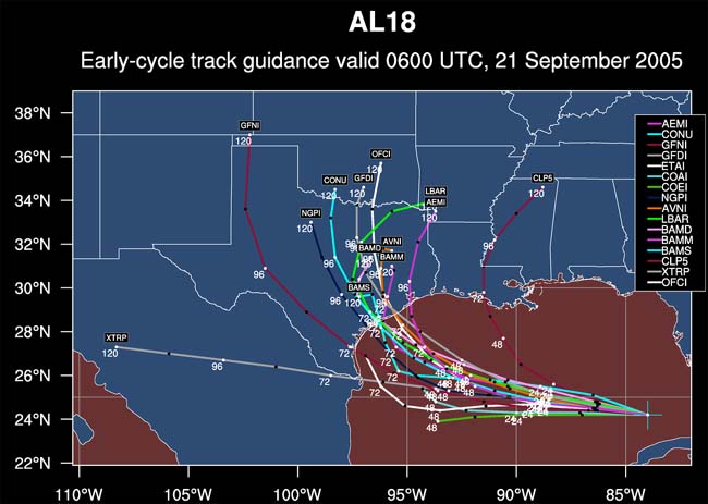
    21stmorningforecastracksy.jpg

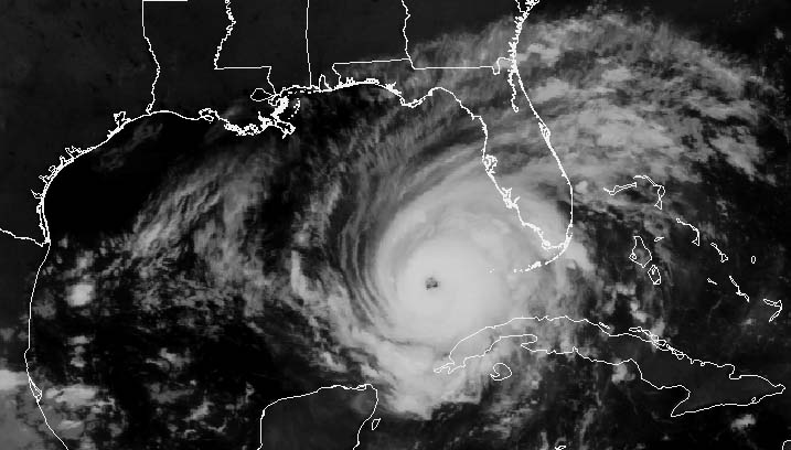
    530ameasternsept21.jpg

    Looking impressive, and bad news for the Texas coast.


  • Registered Users, Registered Users 2 Posts: 12,811 ✭✭✭✭billy the squid


    with sustained winds of 135 mph, Rita now Category 4 hurricane as of 19zadvisory.


  • Registered Users, Registered Users 2 Posts: 11,134 ✭✭✭✭maquiladora


    with sustained winds of 135 mph, Rita now Category 4 hurricane as of 19zadvisory.

    On its way to becoming a very strong Cat 5 eventually, but its likely not to remain cat Cat 5 till landfall. But then again, the water temps are very very high in the Gulf. I really hope people are taking it seriously.


  • Registered Users, Registered Users 2 Posts: 879 ✭✭✭sirpsycho


    That's a fairly large eye


  • Registered Users, Registered Users 2 Posts: 12,811 ✭✭✭✭billy the squid


    streaming video availible
    KHOU Houston texas
    http://www.khou.com/


  • Closed Accounts Posts: 41 claidheamh


    seriously.

    I live on the mainland beach, if you're inclined to call it such. May have oceanfront property when all this is said and done. Storm surge may reach my front door this time at a projected 6m rise in sea level.

    Going to Galveston Island(15 minutes away), this afternoon to evacuate my wife's grandmother (103yr old Italian immigrant). She is quite possibly the most stubborn woman on Earth, and I may need constabulary assistance to extricate her from her home.

    I've stocked up on our backwater version of Guinness, in case my water ceases to work.

    If any of y'all have friends on Galveston Island that need a place to stay, email me or call [Edit by Earthman- Dont leave your number open on the web like that-anyone that wants it can pm me for it or yourself-Edit by Earthman]-but do so quickly.


  • Closed Accounts Posts: 11,909 ✭✭✭✭Wertz


    Jeez. I lived on South Padre Island for a little while and in Port Aransas for a good while too, a few years back. The whole TX gulf coast is "protected" by spit bar islands...a large storm surge such as what Rita looks likely to generate would have the potentail to completely swamp this chain of bars. Lots of expensive beachfront property (including some lived in by people I know) gonna get washed away if this keeps intensifying like it has been. Sh*tload of offshore oil rigs in that area too...if it comes ashorenorth of corpus christi and south of galveston that's about as best case scenario as it's likely to get...either way, this is gonna be a trying time for folks in the coastal bend.

    OSEIiod.jpg


  • Registered Users, Registered Users 2 Posts: 15,544 ✭✭✭✭Supercell


    claidheamh wrote:
    seriously.

    I live on the mainland beach, if you're inclined to call it such. May have oceanfront property when all this is said and done. Storm surge may reach my front door this time at a projected 6m rise in sea level.

    Going to Galveston Island(15 minutes away), this afternoon to evacuate my wife's grandmother (103yr old Italian immigrant). She is quite possibly the most stubborn woman on Earth, and I may need constabulary assistance to extricate her from her home.

    I've stocked up on our backwater version of Guinness, in case my water ceases to work.

    If any of y'all have friends on Galveston Island that need a place to stay, email me or call [Edit by Earthman- Dont leave your number open on the web like that-anyone that wants it can pm me for it or yourself-Edit by Earthman]-but do so quickly.

    Stay safe, dont become another statistic..move to safe ground, the thing that struck me most about what people, that evacuated before Katrina said, was the words "you can rebuild a house but you cannot rebuild a life."
    Struck me as being a very good way to sum it all up.

    Have a weather station?, why not join the Ireland Weather Network - http://irelandweather.eu/


  • Advertisement
  • Registered Users, Registered Users 2 Posts: 11,134 ✭✭✭✭maquiladora


    SEP 21 2005 - 1:20PM CDT

    The latest RECON reports confirm RITA is now a CATASTROPHIC CATEGORY 5 Hurricane.

    Center Pressure is down to 920mb, and MAX Sustained winds of 153KTs at Flight level -- implying 155mph surface winds. with gusts to 175mph.


  • Registered Users, Registered Users 2 Posts: 15,544 ✭✭✭✭Supercell


    SEP 21 2005 - 1:20PM CDT

    The latest RECON reports confirm RITA is now a CATASTROPHIC CATEGORY 5 Hurricane.

    Center Pressure is down to 920mb, and MAX Sustained winds of 153KTs at Flight level -- implying 155mph surface winds. with gusts to 175mph.


    Source linky ?

    Have a weather station?, why not join the Ireland Weather Network - http://irelandweather.eu/


  • Closed Accounts Posts: 11,909 ✭✭✭✭Wertz


    NOAA latest update still has it at cat 4 as of 2.15 EDT
    000
    WTNT63 KNHC 211807
    TCUAT3
    HURRICANE RITA TROPICAL CYCLONE UPDATE
    NWS TPC/NATIONAL HURRICANE CENTER MIAMI FL
    215 PM EDT WED SEP 21 2005

    DATA FROM RECONNAISSANCE AIRCRAFT INDICATE THAT RITA HAS INTENSIFIED
    A LITTLE MORE AND WINDS HAVE REACHED 150 MPH WINDS WITH A MINIMUM
    PRESSURE OF 920 MB. THIS MAKES RITA A STRONG CATEGORY FOUR
    HURRICANE.

    FORECASTER AVILA


  • Registered Users, Registered Users 2 Posts: 11,134 ✭✭✭✭maquiladora


  • Registered Users, Registered Users 2 Posts: 11,134 ✭✭✭✭maquiladora


    Pressure now down to 908mb....thats a 77mb drop in 31 hours.
    Still an awful lot of very warm water to pass over.


  • Registered Users, Registered Users 2 Posts: 12,811 ✭✭✭✭billy the squid


    http://www.nhc.noaa.gov/text/refresh/MIATCUAT3+shtml/211955.shtml

    cat 5 windspeed 165mph. this is going to be bad.


  • Registered Users, Registered Users 2 Posts: 11,134 ✭✭✭✭maquiladora


    http://www.nhc.noaa.gov/text/refresh/MIATCUAT3+shtml/211955.shtml

    cat 5 windspeed 165mph. this is going to be bad.

    Down to 904mb now....
    Rita is currently the fifth most intense hurricane ever according to NHC


  • Registered Users, Registered Users 2 Posts: 12,811 ✭✭✭✭billy the squid


    899 milibars!


    000
    WTNT63 KNHC 212351
    TCUAT3
    HURRICANE RITA TROPICAL CYCLONE UPDATE
    NWS TPC/NATIONAL HURRICANE CENTER MIAMI FL
    650 PM CDT WED SEP 21 2005

    ...RITA BECOMES THE THIRD MOST INTENSE HURRICANE ON RECORD...

    DROPSONDE DATA FROM AN AIR FORCE RESERVE UNIT RECONNAISSANCE
    AIRCRAFT AT 623 PM CDT...2323Z...INDICATED THE CENTRAL PRESSURE HAS
    FALLEN TO BELOW 899 MB...OR 26.55 INCHES. THE DROPSONDE INSTRUMENT
    MEASURED 32 KT/35 MPH WINDS AT THE SURFACE...WHICH MEANS IT LIKELY
    DID NOT RECORD THE LOWEST PRESSURE IN THE EYE OF RITA. THE CENTRAL
    PRESSURE IS PROBABLY AT LEAST AS LOW AS 898 MB...AND PERHAPS EVEN
    LOWER. FOR OFFICIAL PURPOSES... A PRESSURE OF 898 MB IS ASSUMED...
    WHICH NOW MAKES RITA THE THIRD MOST INTENSE HURRICANE IN TERMS OF
    PRESSURE IN THE ATLANTIC BASIN. SOME ADDITIONAL DEEPENING AND
    INTENSIFICATION IS POSSIBLE FOR THE NEXT 12 HOURS OR SO.

    RITA CURRENTLY RANKS BEHIND HURRICANE GILBERT IN 1988 WITH 888 MB
    AND THE 1935 LABOR DAY HURRICANE WITH 892 MB.

    FORECASTER STEWART

    $$


  • Registered Users, Registered Users 2 Posts: 11,134 ✭✭✭✭maquiladora


    899 milibars!

    Wow :eek:

    "PRESSURE IS PROBABLY AT LEAST AS LOW AS 898 MB...AND PERHAPS EVEN
    LOWER."


  • Advertisement
  • Registered Users, Registered Users 2 Posts: 12,811 ✭✭✭✭billy the squid


    http://www.khou.com/perl/common/video/makeadplaylist.pl?title=beloint_khou&adurl=&adclickthru=&adgraphic=&live=yes

    direct link to Channel 11 webstream

    There is a two hour episode of CSI on at the moment but it should return to the coverage of the storm after that.

    they are putting out the normal programmes over the web.


  • Closed Accounts Posts: 6,498 ✭✭✭Mothman


    ESTIMATED MINIMUM CENTRAL PRESSURE 897 MB
    MAX SUSTAINED WINDS 150 KT WITH GUSTS TO 185 KT
    and forecast to increase...

    http://www.nhc.noaa.gov/text/refresh/MIATCMAT3+shtml/220227.shtml?
    000
    WTNT23 KNHC 220227
    TCMAT3
    HURRICANE RITA FORECAST/ADVISORY NUMBER 18
    NWS TPC/NATIONAL HURRICANE CENTER MIAMI FL AL182005
    0300Z THU SEP 22 2005

    A HURRICANE WATCH REMAINS IN EFFECT FOR THE GULF OF MEXICO COAST
    FROM PORT MANSFIELD TEXAS TO CAMERON LOUISIANA. A HURRICANE WARNING
    MAY BE REQUIRED FOR PORTIONS OF THE HURRICANE WATCH AREA THURSDAY
    MORNING.

    HURRICANE CENTER LOCATED NEAR 24.6N 87.2W AT 22/0300Z
    POSITION ACCURATE WITHIN 15 NM

    PRESENT MOVEMENT TOWARD THE WEST-NORTHWEST OR 280 DEGREES AT 8 KT

    ESTIMATED MINIMUM CENTRAL PRESSURE 897 MB
    EYE DIAMETER 20 NM
    MAX SUSTAINED WINDS 150 KT WITH GUSTS TO 185 KT.
    64 KT....... 60NE 60SE 40SW 50NW.
    50 KT....... 90NE 80SE 60SW 90NW.
    34 KT.......160NE 140SE 100SW 160NW.
    12 FT SEAS..275NE 200SE 200SW 275NW.
    WINDS AND SEAS VARY GREATLY IN EACH QUADRANT. RADII IN NAUTICAL
    MILES ARE THE LARGEST RADII EXPECTED ANYWHERE IN THAT QUADRANT.

    REPEAT...CENTER LOCATED NEAR 24.6N 87.2W AT 22/0300Z
    AT 22/0000Z CENTER WAS LOCATED NEAR 24.5N 86.8W

    FORECAST VALID 22/1200Z 24.9N 88.7W
    MAX WIND 155 KT...GUSTS 190 KT.
    64 KT... 70NE 70SE 50SW 60NW.
    50 KT...100NE 90SE 70SW 100NW.
    34 KT...170NE 150SE 110SW 170NW.

    FORECAST VALID 23/0000Z 25.5N 90.5W
    MAX WIND 150 KT...GUSTS 185 KT.
    64 KT... 70NE 70SE 50SW 60NW.
    50 KT...110NE 100SE 80SW 110NW.
    34 KT...180NE 160SE 120SW 180NW.

    FORECAST VALID 23/1200Z 26.3N 92.4W
    MAX WIND 145 KT...GUSTS 175 KT.
    64 KT... 70NE 70SE 50SW 60NW.
    50 KT...120NE 110SE 90SW 120NW.
    34 KT...180NE 170SE 130SW 180NW.

    FORECAST VALID 24/0000Z 27.5N 94.2W
    MAX WIND 135 KT...GUSTS 165 KT.
    50 KT...120NE 110SE 90SW 120NW.
    34 KT...190NE 180SE 130SW 190NW.

    FORECAST VALID 25/0000Z 31.0N 96.4W...INLAND
    MAX WIND 65 KT...GUSTS 80 KT.
    50 KT... 30NE 50SE 20SW 20NW.
    34 KT... 90NE 150SE 60SW 80NW.


    NEXT ADVISORY AT 22/0900Z

    FORECASTER STEWART


  • Registered Users, Registered Users 2 Posts: 12,811 ✭✭✭✭billy the squid


    Rita's central pressure briefly fell to 897 mb but has risen by 1mb to 898mb and windspeed has remained at 175 since the last full advisory at 03z. the 06z intermediate advisory predicts fluctuations in the strength of Rita

    Looks as though Rita might have peaked.


  • Registered Users, Registered Users 2 Posts: 12,811 ✭✭✭✭billy the squid


    pressure falling again 897 mb. according to the 09z advisory.


  • Registered Users, Registered Users 2 Posts: 11,134 ✭✭✭✭maquiladora


    One of the most, if not the most, intense hurricanes ever recorded in the Gulf of Mexico, Rita's last reported central pressure was last measured at 897mb. However, in the past 3 hours since that observation, satellite imagery indicates the convection
    has increased further, and the subsidence in the eye has likewise intensified. It is very likely the next RECON will find a lower central pressure. Estimated sustained surface winds are now 175mph, with gusts to 200mph -- equal to or greater than that recorded in Katrina or Camille. With additional intensification still possible - wind gusts of 210mph may be experienced at the surface.

    The storm is located near 24.6N /87.5W - or about 560 miles southeast of Galveston, TX. The storm is moving 280° at 8Kts and will continue on this track for the next 24 hours.

    Satellite imagery depicts what is now intuitively obvious -- 'The Perfect Storm' -- and it is hard to imagine that the storm can get any stronger -- but there is no particular reason for it weaken unless an eye wall replacement cycle -should begin -- though there are not indications that is imminent. The storm is still over the very warm loop
    current, and will be for another 8-10 hours. Once the storm moves away from the loop current, some slight weakening should occur, but the storm will remain a strong CAT 5 Hurricane for probably another 24-48 hours.
    The storm continues to grow in size, with sustained gale force winds extending 180NM from the center in the northern semi-circle.

    Ocean swells to 12 feet have now reached the north and northeast Gulf coast, and will reach the Texas coast by morning. Ocean wave models indicate that sea height of 80ft or greater are being generated near the storm's eyewall.

    Rita could reach the coast as a CAT 5 hurricane, though a strong CAT 4 seems most probable.. But even if the storm does weaken for any one of the above reasons -- with eye wall replacement being the most probable -- there is no doubt that a CAT 5 Storm Surge will hit the coast. With the still expanding and intensifying circulation field -- the storm may produce a CAT 5 storm surge for a 60-80 mile stretch of coast line from near the point of landfall and extending to the northeast.

    http://www.wunderground.com/blog/SteveGregory/show.html

    hiresirr15.jpg


  • Registered Users, Registered Users 2 Posts: 5,047 ✭✭✭Culchie


    It's exciting this sort of stuff isn't it? ... Is for me anyway.
    I used to live in the Swiss Alps and the Thunderstorms were something else !!

    How far inland does it normally take for a hurricane of this magnitude to weaken to an extent that it becomes a 'tropical storm' ?

    50 .... 100 miles?


  • Advertisement
  • Registered Users, Registered Users 2 Posts: 11,134 ✭✭✭✭maquiladora


    Culchie wrote:
    It's exciting this sort of stuff isn't it? ... Is for me anyway.
    I used to live in the Swiss Alps and the Thunderstorms were something else !!

    How far inland does it normally take for a hurricane of this magnitude to weaken to an extent that it becomes a 'tropical storm' ?

    50 .... 100 miles?

    085837W_sm.gif

    There you go, as you can see by that, Rita will still be hurricane strength about 200 miles inland.


  • Registered Users, Registered Users 2 Posts: 11,134 ✭✭✭✭maquiladora


    Okay, NHC have updated that path since I posted it to show Rita becoming a TS faster than previously expected. So ignore my comment above :P
    Subject to change :D


  • Registered Users, Registered Users 2 Posts: 11,134 ✭✭✭✭maquiladora


    Rita, rita, round she goes...where she stops...nobody knows...

    She's taking a more northward path now, going against most of the models....could be more like a LA landfall rather an a TX one. Houston may have escaped.


  • Registered Users, Registered Users 2 Posts: 12,811 ✭✭✭✭billy the squid


    New Orleans now under Tropical Storm Warning
    media link WWL New Orleans
    http://www.wwltv.com/
    Windows media Player required

    Radar - New Orleans
    http://radar.weather.gov/radar/latest/DS.p20-r/si.klix.shtml

    max sustained winds are 145mph pressure 913 mb

    Katrinas ugly sister.

    everything you wanted to know about Rita can be found at the link below
    http://weather.net-waves.com/td18.php


  • Registered Users, Registered Users 2 Posts: 11,134 ✭✭✭✭maquiladora


  • Advertisement
  • Registered Users, Registered Users 2 Posts: 12,811 ✭✭✭✭billy the squid


    sweet, nice find

    just to note if it doesnt work in firefox, itwill in IE.

    well worth it.

    just to add, if this crashes on you then here are the individual stream links you can watch the videos on this individually

    [url]mms://a617.l1294438616.c12944.g.lm.akamaistream.net/d/617/12944/v0001/reflector:38616[/url]
    [url]mms://beloint.wm.llnwd.net/beloint_khou[/url]
    http://ktrktv.wm.llnwd.net/ktrktv_live


  • Registered Users, Registered Users 2 Posts: 12,811 ✭✭✭✭billy the squid


    rita has killed at least 30 people before even making landfall. several people have died from heat exhaustion while trying to escape yesterday and a bus explosion in the last hour has killed at least 20 people outside dallas, the bus was full of evacuees.


  • Registered Users, Registered Users 2 Posts: 12,811 ✭✭✭✭billy the squid


    Rits eye visible on New Orleans long range radar
    http://radar.weather.gov/radar/latest/DS.p20-r/si.klix.shtml


  • Registered Users, Registered Users 2 Posts: 5,047 ✭✭✭Culchie


    Rits eye visible on New Orleans long range radar
    http://radar.weather.gov/radar/latest/DS.p20-r/si.klix.shtml


    Rits eye ? :o


  • Registered Users, Registered Users 2 Posts: 11,134 ✭✭✭✭maquiladora


    Rita looks like she's starting to weaken a lot, whether she will have time or the ability to strengthen again before landfall is not known, but she probably won't. Good news, but the storm surge will still be huge and nothing can stop that at this stage.


  • Registered Users, Registered Users 2 Posts: 12,811 ✭✭✭✭billy the squid


    Culchie wrote:
    Rits eye ? :o

    yeah the little round black area in the centre of the hurricane is called the eye, it is surrounded by the strongest part of the hurricane. :)


  • Moderators, Society & Culture Moderators, Sports Moderators Posts: 12,326 Mod ✭✭✭✭Kingp35


    Rita seems to have changed direction and is heading towards Louisianna now rather than Texas meaning that Louisianna will be getting the worst of the storm


Advertisement