Advertisement
Help Keep Boards Alive. Support us by going ad free today. See here: https://subscriptions.boards.ie/.
If we do not hit our goal we will be forced to close the site.

Current status: https://keepboardsalive.com/

Annual subs are best for most impact. If you are still undecided on going Ad Free - you can also donate using the Paypal Donate option. All contribution helps. Thank you.
https://www.boards.ie/group/1878-subscribers-forum

Private Group for paid up members of Boards.ie. Join the club.

Google rearranges Cork

  • 06-12-2024 06:49PM
    #1
    Registered Users, Registered Users 2 Posts: 746 ✭✭✭


    Has anyone else noticed how useless the addresses generated by Google Maps are for Cork City? I am wondering if this is a specific issue to Cork or a more general one.

    For example, a lot of the southside and the city centre is apparently in "Ballintemple" which stretches as far west as Barrack Street.

    Shandon Street appears as part of Sunday's Well or part of Gurranabraher.

    Glasheen is in Togher.

    "Victorian Quarter" appears as part of some addresses which will not please some.

    Kent Station is in Montenotte.

    Parts of the city centre which are not in Sunday's Well or Ballintemple are in a neighbourhood called "Centre".

    These locations have now begun to propagate into real life as people use Google Maps as a reference for printed material and other references.

    I'm curious as to how this came about. Presumably Google harvested this information from some other source - but what source would use locations like these? Why didn't they use something like the Wards and Electoral Divisions? It's not like they are hard to find.


Comments

  • Registered Users, Registered Users 2 Posts: 746 ✭✭✭lostinsuperfunk


    Actually the Shandon Street addresses do seem to come from the Council Wards - the west side of the street appears to lie in Sunday's Well or Gurranabraher.

    But what's the story with the others?

    https://www.geohive.ie/datasets/osi%3A%3Aelectoral-divisions-national-statutory-boundaries-2019/explore?location=51.900640%2C-8.482651%2C15.00


  • Registered Users, Registered Users 2 Posts: 772 ✭✭✭DylanQuestion


    I never understood Ballintemple either. Ballintemple is basically just the village itself and maybe Pairc Ui Chaoimh. A tiny area. Meanwhile, on Google it says South Parish and the Docklands are Ballintemple. My house is listed as Rochestown, Cork. While I’m not complaining, not once have I ever heard somebody refer to my house as anything other than Douglas, Cork (Maryborough Hill). Meanwhile, Eircode just says Maryborough Hill, Cork


    Centre does make sense as a neighbourhood, however, and I have seen actual businesses start to use it as an address. I used to always wonder to my parents when I was younger “our address says Douglas, Cork, and granny and grandad’s says Turner’s Cross, Cork - what does it say for people on Patrick Street?”. I have noticed in the letters from the council to owners of vacant buildings, they now list addresses as, for example, “Cook Street, City Centre, Cork”


    I guess it’s all a little subjective. For example, when you come out of Mahon Point you have signs directing you to “Mahon”, which you’re already in. On the Rochestown Road and Frankfield Road, there are signs for “Cork” and “City Centre” next to eachother*. On Grange Road, there is a sign for “City Centre N27”, meanwhile when you get closer to the city centre it changes to “Cork (Centre) N27”. The “Cork (Centre)” sign is right over a sign saying “Turners Cross”, too. Same at Wilton with “UCC” next to a “Cork (Centre)” sign

    *TII confirmed to me this means you can use the road for specifically the city centre or the other parts of Cork outside of that area the sign is in


  • Registered Users, Registered Users 2 Posts: 721 ✭✭✭calnand


    Yeah I've sent feedback about the Glasheen/Tougher/Wilton issue multiple times, but nothing has changed. If you click on the house the address will show as Glasheen, but clicking on the road outside the house shows Togher. Then if you search for a house in Glasheen and put Togher in the address it changes it to Glasheen.


  • Registered Users, Registered Users 2 Posts: 17,989 ✭✭✭✭the beer revolu


    Regarding Shandon Street, it has the east side of the street in "Shandon" - all the way to the west side of Letrim Street and south to Pope's Quay. That feels right to me.


  • Registered Users, Registered Users 2 Posts: 4,705 ✭✭✭Balmed Out


    I remember looking at an old map where Blackrock an Mahon were tiny. Blackrock was from village along ringmahon to water with the city side of the village immediately being part of Ballintemple. Mahon was just between ringmahon road and skehard with outside that being either Blackrock or Ballinure. Other peculiarity I remember was an area in Ballinlough near Eglantine being seperate parish or townland called coppingers court.


  • Advertisement
  • Registered Users, Registered Users 2 Posts: 31,552 ✭✭✭✭breezy1985


    Google maps, Uber and the likes add "Prior's Land" to most addresses around the main streets of Limerick.

    The place does exist historically and was the area just outside the walls in what are now the main streets. But most people wouldn't know that as it was never part of your written postal address.

    Some delivery sites also have names like "castle" and "abbey" in the address which is a council ward but not part of the postal address in real life.


  • Registered Users, Registered Users 2 Posts: 772 ✭✭✭DylanQuestion


    Uber lists Douglas Road and South Douglas Road is Ballinlough!


  • Registered Users, Registered Users 2 Posts: 17,989 ✭✭✭✭the beer revolu


    Well, it is arguable that these roads aren't really in "Douglas", which is actually a village. St Finbarr's hospital certainly isn't in Douglas but is on the Douglas Road. Same way Dosco industrial estate wouldn't be considered Douglas. I'm not sure there is an area called Douglas (although there is a parish).


  • Registered Users, Registered Users 2 Posts: 772 ✭✭✭DylanQuestion


    Yeah, they fall into a grey area. There are townloads in the area like Tramore and Dunmahon. I just would consider them Douglas faster than I'd consider them Ballinlough


  • Registered Users, Registered Users 2 Posts: 17,989 ✭✭✭✭the beer revolu


    Yeah, to be fair, I wouldn't consider those places to be Ballinlough either - certainly not the South Douglas Road.


  • Advertisement
  • Registered Users, Registered Users 2 Posts: 70 ✭✭Leatra


    As far as I know, Ballinlough extends to the north side of the Douglas Road, all the way to the Well Road and the flyover, but doesn't cross it. It's probably absorbed Browningstown as well, but it definitely shouldn't extend to the South Douglas Road. Those areas (Ballincurrig, Skahabeg, Tramore) occupy an odd spot as they don't particularly gravitate towards any of the nearby village cores (Ballinlough, Douglas, Turner's Cross). Suburban sprawl gets a bit arbitrary!

    The Ballinlough Road was, historically, the road to Ballinlough (not through it, as it's mostly used now), which seems from old OS Maps to have centred around the Manfu House. The lough in question was the Douglas Estuary, with Ballinlough House (the large pink building on Churchyard Lane) and the old post office above it at the top of the Well Road.

    Google Maps is fairly reckless at times with its labelling, and it can be nigh impossible to correct. I noticed a lot of strange new place-names had appeared a while back around Ardmore in west Waterford - names like Bosheen and Kilhile - that turned out to have duplicated from around the mouth of the Barrow in south Wexford. It took years for them to finally disappear, long after I reported it.


  • Registered Users, Registered Users 2 Posts: 772 ✭✭✭DylanQuestion


    I made a bunch of reports last week on incorrect street names, and the only thing they accepted was renaming "Cork Bus Station" to "Parnell Place Bus Station". The rest (such as putting Parnell Place in English, correctly labelling Carrigaline Road as R609 and not R855, or adding Dyke Parade) were all rejected


  • Registered Users, Registered Users 2 Posts: 55 ✭✭Hailtothethief


    Don't forget that cartographers often make deliberate mistakes in their maps. If their mistakes pop up on other maps, it's obvious that their maps have been copied without permission.…


  • Registered Users, Registered Users 2 Posts: 17,989 ✭✭✭✭the beer revolu


    That's very interesting. I never considered Ballinlough to ever be a village, perhaps there once was a village of Ballinlough.

    I always wondered what area to call Churchyard Lane. Always felt it wasn't Douglas, wasn't Ballinlough, wasn't Ballintemple, definitely not Mahon or Blackrock. I never knew that house was Ballinlough house - I worked there when it was Lovett's.


  • Registered Users, Registered Users 2 Posts: 772 ✭✭✭DylanQuestion


    The houses at the junction of Ballinlough Road and Churchyard Lane have Ballinlough in their address. However, I remember when Aylesbury was being marketed, they advertised it as Ballintemple. I would consider the part between the Well Road junction and Aylesbury to be Ballinlough, and the rest Ballintemple


    The big question for me is Well Road, Skehard Road and Boreenmana Road. I would consider them Ballinlough, Blackrock and Ballintemple respectively. However, my dad grew up in Lake Lawn and his address at the time was Douglas, so who knows


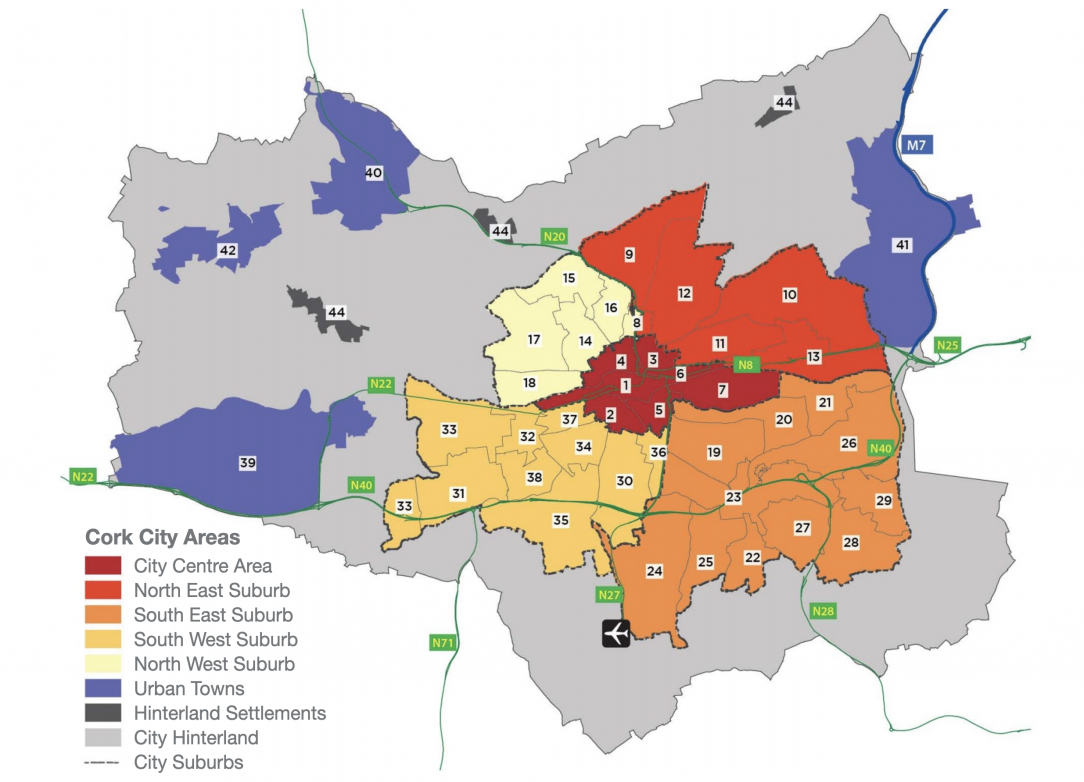
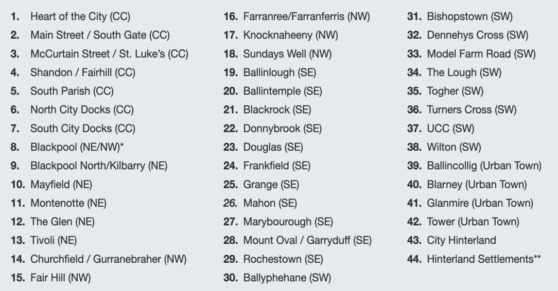
    The City Council have a map of all of the ‘official’ neighbourhoods I can post later


  • Registered Users, Registered Users 2 Posts: 772 ✭✭✭DylanQuestion


    Screenshot 2024-12-10 at 23.04.15.png

    As promised

    Screenshot 2024-12-10 at 23.04.33.png


  • Registered Users, Registered Users 2 Posts: 4,705 ✭✭✭Balmed Out


    I grew up near Lake Lawn, was always known as part of Ballinlough but Ballinlough was never part of the address but rather Douglas Road as opposed to just Douglas.


  • Registered Users, Registered Users 2 Posts: 1,770 ✭✭✭notAMember


    There are two Churchyard Lanes. One is in douglas, near St Lukes Church.

    The one you're talking about, past Lovett's & the old school (which later became the sorting office, and is now private house) has the same name.

    That place right there at Lovetts was called Gregg's Cross before the current name. I guess that's something to do with John Gregg, the bishop of Cork who oversaw the building of St Finbarrs, or his sons, but that's just a guess as I have no idea of any association between him and that street.

    Churchyard Lane continues up Temple hill, past Con rugby club, past the pitch and putt club, past the quarry, and down the narrow hill on the other side to meet Blackrock Road at Ballintemple. The "chuchyard" in the name, is the tiny old Ballintemple Graveyard at the top of the junction of the boreenmanna road and Churchyard lane, behind the quarry. It's from the 1600's.


Advertisement